Here's something you might be interested in.
Ask a Hipster — Advice you didn't know you needed
Big Screen — Movie commentary
Blurt — Music's inside track
Booze News — San Diego spirits
Classical Music — Immortal beauty
Classifieds — Free and easy
Cover Stories — Front-page features
Drinks All Around — Bartenders' drink recipes
Excerpts — Literary and spiritual excerpts
Feast! — Food & drink reviews
Feature Stories — Local news & stories
Fishing Report — What’s getting hooked from ship and shore
From the Archives — Spotlight on the past
Golden Dreams — Talk of the town
The Gonzo Report — Making the musical scene, or at least reporting from it
Letters — Our inbox
Movies@Home — Local movie buffs share favorites
Movie Reviews — Our critics' picks and pans
Musician Interviews — Up close with local artists
Neighborhood News from Stringers — Hyperlocal news
News Ticker — News & politics
Obermeyer — San Diego politics illustrated
Outdoors — Weekly changes in flora and fauna
Overheard in San Diego — Eavesdropping illustrated
Poetry — The old and the new
Reader Travel — Travel section built by travelers
Reading — The hunt for intellectuals
Roam-O-Rama — SoCal's best hiking/biking trails
San Diego Beer — Inside San Diego suds
SD on the QT — Almost factual news
Sheep and Goats — Places of worship
Special Issues — The best of
Street Style — San Diego streets have style
Surf Diego — Real stories from those braving the waves
Theater — On stage in San Diego this week
Tin Fork — Silver spoon alternative
Under the Radar — Matt Potter's undercover work
Unforgettable — Long-ago San Diego
Unreal Estate — San Diego's priciest pads
Your Week — Daily event picks
Rough beauty on Ocotillo Ridge
What is the difference between a thorn and a spine?
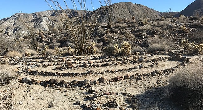
A mini-labyrinth can be found on the Ocotillo Ridge Trail
Three geothermal natural springs once flowed freely from the northern face of the Tierra Blanca Mountains, creating a desert oasis that was known to the Kumeyaay people. The abundant water now fills swimming pools and spas with up to 102°F water that both young and old can enjoy at Agua Caliente County Park. This park and the adjacent Vallecito County Park are surrounded by the Anza-Borrego Desert State Park. In addition to the hot springs and campground, Agua Caliente County Park has trails for hiking.
The Ocotillo Ridge Trail is one place where you can plan ahead to view desert wildflowers. When you hear about wildflowers in the Borrego Valley area, it is time to plan your trip to Agua Caliente, because blooms come later in the higher elevations of the Anza-Borrego region.
From the entrance ranger station (where fees are paid), a trail rises above the pools and desert oasis. As you start toward the amphitheater, take the left fork, labeled “Desert Overlook Trail.” Continue down this path for 0.25 mile to enter the surrounding desert. Take note that the terrain will be rough. Most of the trail will be level, but many of the plants here have thorns or spines. Keep an eye out for cholla that can easily attach itself to clothing or shoes and go along for a ride. Trivia question: what is the difference between a thorn and a spine? Thorns, like on the ocotillo, are modified branches, while the spines on the cactus are modified leaves.
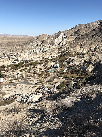
A sweeping view of Agua Caliente Regional Park from the Desert Overlook trail
Past the ocotillo and dried agave, you will find a fork to the Desert Overlook Trail and the Marsh Trail. For sweeping views of the pools, day-use picnic areas, and natural riparian corridors, take the 0.25-mile fork straight up. Note that this trail is very steep and rocks can be loose. This side trip is one way out-and-back, so go as far as you feel comfortable. The trail’s end is marked by a series of rock cairns. As you head back the way you came, you can see the arroyo the Marsh Trail explores.
Once you are back at the sign-post, take the other fork, labeled “Marsh Trail” for a few yards before reaching the Ocotillo Ridge Trail. The Ocotillo Ridge Trail takes you past a variety of cactus species and can be an ideal place to see them in bloom. There is little elevation change along the ridge.
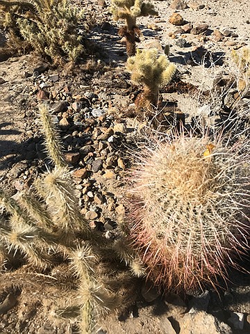
Beware of cholla and cactus spines on the trail
If you missed the turnoff to the ridge trail, or if you seek shade as the weather grows warm, you can take the steep fork down into the arroyo of Squaw Canyon. Both routes meet up and loop back to the amphitheater farther along the trail. On Ocotillo Ridge, you will also find a false fork in the trail. One route will continue on the trail, the other will lead you into a mini-labyrinth. Don’t worry, both trails are close to each other, and while the labyrinth dead ends, you can easily cross back to the main trail.
The last portion of the Ocotillo Ridge Trail follows on the cliff above the Marsh Trail (to your left). They are separated by 0.1 mile. Once you reach the end of Ocotillo Ridge Trail, go right to return the last 0.25 mile to the ranger station, going past the amphitheater.
Driving Directions: (Agua Caliente County Park) From the north, take SR-78 through Julian to Scissors Crossing and take S-2 (Great Overland Stage Route of 1849) south toward Ocotillo 22.2 miles to the entrance of Agua Caliente County Park. From the south take I-8 east and exit at Ocotillo. Take S-2 north and drive 26.7 miles to the entrance of Agua Caliente County Park, being careful to turn south from S-2 into the park entrance near the airstrip. Facilities available. Park across from the ranger pay station (day use parking is $3 per vehicle). Or, park on the side street just east of the Agua Caliente Springs General Store and walk into the park—this will add 1 mile to the round trip. Do not park in the General Store’s small parking lot. If you use the General Store’s restrooms, be nice and buy something at the store, or use the restrooms inside the park.
Hiking length: 1.25 or 2.25 miles depending on where you park including side trip to the overlook. Allow approximately 1 or 1.5 hours hiking time.
Difficulty: Easy to moderate with 179 feet elevation gain, including the side trip to the overlook. Uneven terrain with cactus near the trail. Note: Agua Caliente County Park is closed June, July, and August; day use for trails is sunrise to sunset. Pools are open for day use 9:30 am to 5 pm. Day use pool entry for non-campers is $3. No dogs allowed on trails.
Here's something you might be interested in.
Rough beauty on Ocotillo Ridge
What is the difference between a thorn and a spine?
Rough beauty on Ocotillo Ridge
What is the difference between a thorn and a spine?
A mini-labyrinth can be found on the Ocotillo Ridge Trail
Three geothermal natural springs once flowed freely from the northern face of the Tierra Blanca Mountains, creating a desert oasis that was known to the Kumeyaay people. The abundant water now fills swimming pools and spas with up to 102°F water that both young and old can enjoy at Agua Caliente County Park. This park and the adjacent Vallecito County Park are surrounded by the Anza-Borrego Desert State Park. In addition to the hot springs and campground, Agua Caliente County Park has trails for hiking.
The Ocotillo Ridge Trail is one place where you can plan ahead to view desert wildflowers. When you hear about wildflowers in the Borrego Valley area, it is time to plan your trip to Agua Caliente, because blooms come later in the higher elevations of the Anza-Borrego region.
From the entrance ranger station (where fees are paid), a trail rises above the pools and desert oasis. As you start toward the amphitheater, take the left fork, labeled “Desert Overlook Trail.” Continue down this path for 0.25 mile to enter the surrounding desert. Take note that the terrain will be rough. Most of the trail will be level, but many of the plants here have thorns or spines. Keep an eye out for cholla that can easily attach itself to clothing or shoes and go along for a ride. Trivia question: what is the difference between a thorn and a spine? Thorns, like on the ocotillo, are modified branches, while the spines on the cactus are modified leaves.
A sweeping view of Agua Caliente Regional Park from the Desert Overlook trail
Past the ocotillo and dried agave, you will find a fork to the Desert Overlook Trail and the Marsh Trail. For sweeping views of the pools, day-use picnic areas, and natural riparian corridors, take the 0.25-mile fork straight up. Note that this trail is very steep and rocks can be loose. This side trip is one way out-and-back, so go as far as you feel comfortable. The trail’s end is marked by a series of rock cairns. As you head back the way you came, you can see the arroyo the Marsh Trail explores.
Once you are back at the sign-post, take the other fork, labeled “Marsh Trail” for a few yards before reaching the Ocotillo Ridge Trail. The Ocotillo Ridge Trail takes you past a variety of cactus species and can be an ideal place to see them in bloom. There is little elevation change along the ridge.
Beware of cholla and cactus spines on the trail
If you missed the turnoff to the ridge trail, or if you seek shade as the weather grows warm, you can take the steep fork down into the arroyo of Squaw Canyon. Both routes meet up and loop back to the amphitheater farther along the trail. On Ocotillo Ridge, you will also find a false fork in the trail. One route will continue on the trail, the other will lead you into a mini-labyrinth. Don’t worry, both trails are close to each other, and while the labyrinth dead ends, you can easily cross back to the main trail.
The last portion of the Ocotillo Ridge Trail follows on the cliff above the Marsh Trail (to your left). They are separated by 0.1 mile. Once you reach the end of Ocotillo Ridge Trail, go right to return the last 0.25 mile to the ranger station, going past the amphitheater.
Driving Directions: (Agua Caliente County Park) From the north, take SR-78 through Julian to Scissors Crossing and take S-2 (Great Overland Stage Route of 1849) south toward Ocotillo 22.2 miles to the entrance of Agua Caliente County Park. From the south take I-8 east and exit at Ocotillo. Take S-2 north and drive 26.7 miles to the entrance of Agua Caliente County Park, being careful to turn south from S-2 into the park entrance near the airstrip. Facilities available. Park across from the ranger pay station (day use parking is $3 per vehicle). Or, park on the side street just east of the Agua Caliente Springs General Store and walk into the park—this will add 1 mile to the round trip. Do not park in the General Store’s small parking lot. If you use the General Store’s restrooms, be nice and buy something at the store, or use the restrooms inside the park.
Hiking length: 1.25 or 2.25 miles depending on where you park including side trip to the overlook. Allow approximately 1 or 1.5 hours hiking time.
Difficulty: Easy to moderate with 179 feet elevation gain, including the side trip to the overlook. Uneven terrain with cactus near the trail. Note: Agua Caliente County Park is closed June, July, and August; day use for trails is sunrise to sunset. Pools are open for day use 9:30 am to 5 pm. Day use pool entry for non-campers is $3. No dogs allowed on trails.
CommentsMarkFinlay
This comment was removed by the site staff for violation of the usage agreement.
May 17, 2018
FlorenceEliza
This comment was removed by the site staff for violation of the usage agreement.
May 24, 2018
SkylaJensen
This comment was removed by the site staff for violation of the usage agreement.
May 28, 2018
happywheelsgame
This comment was removed by the site staff for violation of the usage agreement.
June 6, 2018
happywheelsgame
This comment was removed by the site staff for violation of the usage agreement.
June 6, 2018
happywheelsgame
This comment was removed by the site staff for violation of the usage agreement.
June 6, 2018
happywheelsgame
This comment was removed by the site staff for violation of the usage agreement.
June 6, 2018
mitchal123423
This comment was removed by the site staff for violation of the usage agreement.
June 6, 2018
Jonathan87
This comment was removed by the site staff for violation of the usage agreement.
June 11, 2018
billdrop
This comment was removed by the site staff for violation of the usage agreement.
Aug. 10, 2018
cofel12
This comment was removed by the site staff for violation of the usage agreement.
Oct. 31, 2018
cofel12
This comment was removed by the site staff for violation of the usage agreement.
Nov. 4, 2018
cofel12
This comment was removed by the site staff for violation of the usage agreement.
Nov. 4, 2018
IselinSolheim
This comment was removed by the site staff for violation of the usage agreement.
May 3, 2019
boundbuzz
This comment was removed by the site staff for violation of the usage agreement.
Sept. 19, 2019
rahul221sharmaa
This comment was removed by the site staff for violation of the usage agreement.
Oct. 22, 2019
[email protected]
This comment was removed by the site staff for violation of the usage agreement.
May 16, 2021