Here's something you might be interested in.
Ask a Hipster — Advice you didn't know you needed
Big Screen — Movie commentary
Blurt — Music's inside track
Booze News — San Diego spirits
Classical Music — Immortal beauty
Classifieds — Free and easy
Cover Stories — Front-page features
Drinks All Around — Bartenders' drink recipes
Excerpts — Literary and spiritual excerpts
Feast! — Food & drink reviews
Feature Stories — Local news & stories
Fishing Report — What’s getting hooked from ship and shore
From the Archives — Spotlight on the past
Golden Dreams — Talk of the town
The Gonzo Report — Making the musical scene, or at least reporting from it
Letters — Our inbox
Movies@Home — Local movie buffs share favorites
Movie Reviews — Our critics' picks and pans
Musician Interviews — Up close with local artists
Neighborhood News from Stringers — Hyperlocal news
News Ticker — News & politics
Obermeyer — San Diego politics illustrated
Outdoors — Weekly changes in flora and fauna
Overheard in San Diego — Eavesdropping illustrated
Poetry — The old and the new
Reader Travel — Travel section built by travelers
Reading — The hunt for intellectuals
Roam-O-Rama — SoCal's best hiking/biking trails
San Diego Beer — Inside San Diego suds
SD on the QT — Almost factual news
Sheep and Goats — Places of worship
Special Issues — The best of
Street Style — San Diego streets have style
Surf Diego — Real stories from those braving the waves
Theater — On stage in San Diego this week
Tin Fork — Silver spoon alternative
Under the Radar — Matt Potter's undercover work
Unforgettable — Long-ago San Diego
Unreal Estate — San Diego's priciest pads
Your Week — Daily event picks
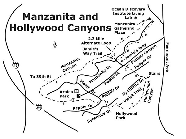
The Canyoneers walk two cleaned-up canyons
Flourishing, accessible native habitats in an urban setting
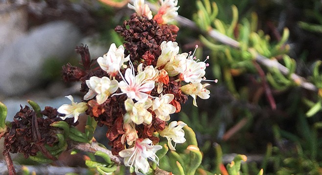
California buckwheat (Eriogonum fasciculatum) in bloom
Manzanita and Hollywood Canyons demonstrate the ability of nature to thrive in disturbed areas and neighborhoods. Not only are these canyons necessary habitats for native flora and fauna, they also act as windows into San Diego County’s natural environments. Both canyons connect to commonly used parks that provide a corridor to these natural worlds, easily accessed by the community of Azalea Park, which has taken action over the years to sustain an accessible native habitat through decreasing human homesteaders and potential fire dangers. In that action’s wake, a thriving canyon community of birds, mammals, reptiles, insects, and plants have continued to contribute to necessary green belts and to our understanding of natural connectivity.
Azalea Community Park is a great starting point for this urban canyon loop. Well maintained facilities and a community center hide a kids’ playground and basketball court. Just beyond this, hikers approach a grassy slope downward to a eucalyptus stand and a few pine trees to the right. The trail begins just past the pines, veering to the right toward the I-15 freeway. It narrows before banking right along a fence separating the trail from freeway access. A short incline ends just before a steady descent along wooden stairs heading to the canyon bottom. The path down is bordered on the right by common chaparral plants, such as chamise (Adenostoma fasciculatum), California buckwheat (Eriogonum fasciculatum), and wart-stemmed ceanothus (Ceanothus verrucosus). Once at the bottom, the trail opens up to expose the west drainage site of Manzanita Canyon.
Caution is advised from this point forward as loose river rock makes up many parts of the trail. The round rocks that compose the stream bed for the length of the canyon make the rating for this hike moderate. Also keep in mind that the canyons here are active drainages and will flow heavily with water during a rainy period. They are not hikable while it is raining.
The trail winds in and out of the dry creek bed, first passing a marked access path to 39th Street on the left, and a rest area further along under a large Peruvian pepper tree (Schinus molle), complete with benches made from fallen trees. Peruvian pepper trees are one of the many non-native plant species which have become naturalized. Some of these non-native species may outcompete established plant communities for resources. Invasive species such as iceplant, sweet fennel, and castor bean have been common in these canyons for some time. This trend is reversing, however, due to consistent community involvement.
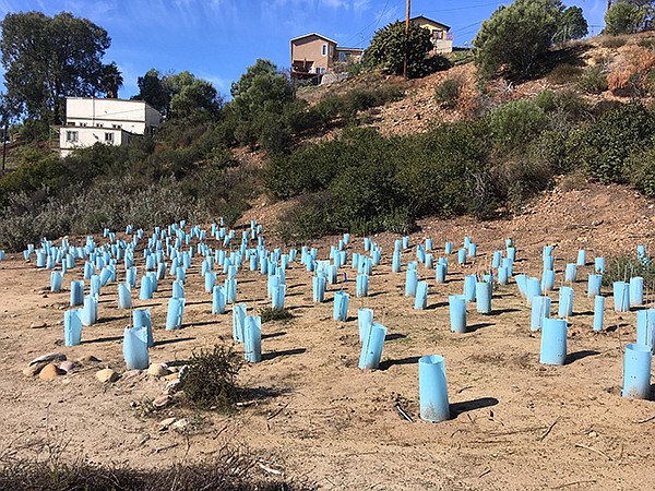
Protective cones help keep young native plants safe from grazers
Along the canyon sides, hikers may notice blue cylindrical cones covering small plants. The cones are used to protect these young native plants from becoming food for the common cottontail rabbit (Sylvilagus audobonii). In an effort to increase the native plant population, San Diego Canyonlands planted 716 native plants in the winter of 2016-2017 and have monitored their survival on a monthly basis since. Half of the natives have survived their first year in the ground, with 325 new native individuals planted in the 2017-2018 planting season. Many pre-established individuals of common chaparral and coastal sage scrub species are also present along the canyon bed.
Manzanita Canyon offers an excellent representation of the native habitats found throughout San Diego County. The plants that compose chaparral and coastal sage scrub communities have evolved adaptations to deal with the arid climate of Southern California and Baja California. Thick-leaved yerba santa (Eriodictyon crassifolium) can gather and retain substantial morning moisture with its thick fuzzy leaves that increase water-gathering surface area, while the folded taco-shaped leaves of laurel sumac (Malosma laurina) divert water downward toward the center of its stand and reduce heat absorption. San Diego mountain mahogany (Cercocarpus minutiflorus) is one of a few San Diego natives that can readily resprout from its root crown after a fire. Another prominent native plant, which this canyon is named for, actually requires fire to germinate its seeds. Unfortunately, according to local residents, there are very few of these manzanitas (Arctostaphylos sp.) left in the canyon due to a lack of fire events and competition from non-native plants.
Some native plant species are important food sources for resident birds in the area. The California towhee (Melozone crissalis) and northern mockingbird (Mimus polyglottos) will eat berries from toyon (Heteromeles arbutifolia) and lemonadeberry (Rhus integrifolia), which grow exceptionally well in these canyons. Two types of woodpeckers have been observed here as well, both of which can be seen with red patches on their heads. The acorn woodpecker (Melanerpes formicivorus) stashes acorns from Quercus species in trees and wooden telephone poles, while the beautifully patterned Nuttall’s woodpecker (Picoides nutallii) can be seen in neighborhood trees.
Many canyon birds are also present throughout the neighborhood among residences. A marked side trail through Jamie’s Way takes hikers back up to Manzanita Drive where bushtits (Psaltriparus minimus) and white-crowned sparrows (Zonotrichia leucophrys) may be seen. This trail is the first access point to the right and cuts the hike down to 1.7 miles, leading directly to Pepper Canyon via Jamie’s Way.
For a longer 2.3 mile hike, continue straight through Manzanita Canyon until the canyon opens into a street. A brand new educational venue for the community to the left, called The Ocean Discovery Institute, has just been built and marks the east end of Manzanita Canyon. This is a great place for kids to interact with and learn about our natural habitats. Follow a short switchback up the bluff to the right where the Manzanita Gathering Place is found. From here, follow Manzanita Drive for 0.3 mile until reaching the Jamie’s Way intersection. Turn left on Jamie’s Way and continue across Poplar Street to Pepper Canyon.
The short Pepper Canyon section, lined with mule-fat (Baccharis salicifolia), is intersected by a paved street, Pepper Drive. Cross the street and continue toward Hollywood Canyon via the trail entrance slightly to the right. The trail borders backyards and fences until reaching a staircase under the naturalized Peruvian pepper tree. Follow the sign at the bottom of the stairs toward Sumac Drive and Violet Street Trails. The creek bed trail along Hollywood Canyon is uneven and narrow at some points, so watch your footing along this section of the trail. This short path is lined with healthy lemonadeberry and holly-leaf cherry (Prunus ilicifolia) that provides shade for the native sunflower, goldenbush (Isocoma menziesii), and structure for a common native perennial herb that climbs the foliage of other plant, wild cucumber (Marah macrocarpa).
The pathway ends at the entrance to Hollywood Park where the trail continues through the park. Make your way to the upper field and head to the right where a sign points the way through a fence to Violet Street. This junction is home to the other naturalized pepper tree in the area, Brazilian pepper tree (Schinus terebinthifolius). The noticeable difference from the Peruvian pepper tree is the larger compound leaves and more vibrant red color of the pepper-scented fruits.
In the last couple years, homeless encampments located throughout the canyons and outlets have diminished due to community involvement and clean-up efforts aimed at rehabilitating the native canyon habitats. Through the efforts of various conservation groups, 290 dumpsters full of trash and nonnative plants were collected by 2,248 volunteers in Manzanita Canyon and its dry tributaries over 1.5 years, from May 2016 to November 2017. With 66 percent of volunteers in this study hailing from the City Heights community, it is obvious that an active public can affect positive change, not only for its neighborhood but also for the natural habitat that thrives alongside it.
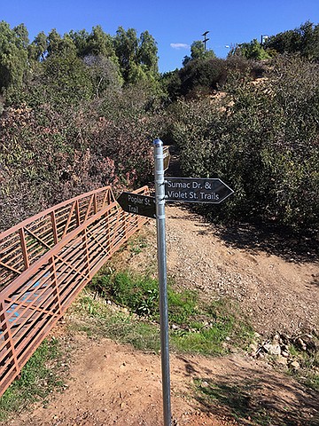
Trail sign at bottom of Hollywood Canyon
Continue through the fence along a well-maintained path until reaching a fork. Take the trail to the left, which is bordered by large Indian fig cactus (Opuntia sp.). Take a moment to look for small white splotches on the prickly pear pads. This waxy white substance produced by the nymphs of the scale insect, cochineal (Dactylopius coccus), acts as a protective covering for the small insect to decrease water loss. Ironically, this white protection is an obvious signal to cochineal harvesters that the insect, which produces carminic acid used to make red carmine dye, is present. The trail then opens onto Violet Street. Make a right on this street and follow until reaching Pepper Drive. Cross the street and turn left onto Pepper Drive. After passing the two corner houses, the final stretch of the trail continues through the alley on the right.
Witness the mural in the alley painted by local artists and then reach the Azalea Park Water Conservation Garden, which is the end of the trail.
It is clear from this hike that this neighborhood has worked hard to conserve the native plant communities and to keep the canyons clean. It shows that in our dense neighborhoods that community involvement can and will restore these urban local habitats.
Driving Directions: (City Heights) From I-5, take CA-94 east and exit at Home Avenue. Turn left and continue on Home Avenue for 1 mile. From I-805 North/South, take Home Avenue and go east for 0.3 mile. Turn left on Fairmount Avenue and travel up hill for 0.7 mile. Take a sharp left onto Poplar Street and continue for 0.5 mile to the entrance to Azalea Community just beyond the stop sign at Violet Street. The parking lot is free and rarely full. Facilities available.
Hiking Length: 2.3 miles or 1.7 miles, loop. Allow 1-2 hours.
Difficulty: Moderate. Elevation gain minimal. Best during daylight hours. Leashed dogs are allowed on the trail.
Here's something you might be interested in.
The Canyoneers walk two cleaned-up canyons
Flourishing, accessible native habitats in an urban setting
The Canyoneers walk two cleaned-up canyons
Flourishing, accessible native habitats in an urban setting
California buckwheat (Eriogonum fasciculatum) in bloom
Manzanita and Hollywood Canyons demonstrate the ability of nature to thrive in disturbed areas and neighborhoods. Not only are these canyons necessary habitats for native flora and fauna, they also act as windows into San Diego County’s natural environments. Both canyons connect to commonly used parks that provide a corridor to these natural worlds, easily accessed by the community of Azalea Park, which has taken action over the years to sustain an accessible native habitat through decreasing human homesteaders and potential fire dangers. In that action’s wake, a thriving canyon community of birds, mammals, reptiles, insects, and plants have continued to contribute to necessary green belts and to our understanding of natural connectivity.
Azalea Community Park is a great starting point for this urban canyon loop. Well maintained facilities and a community center hide a kids’ playground and basketball court. Just beyond this, hikers approach a grassy slope downward to a eucalyptus stand and a few pine trees to the right. The trail begins just past the pines, veering to the right toward the I-15 freeway. It narrows before banking right along a fence separating the trail from freeway access. A short incline ends just before a steady descent along wooden stairs heading to the canyon bottom. The path down is bordered on the right by common chaparral plants, such as chamise (Adenostoma fasciculatum), California buckwheat (Eriogonum fasciculatum), and wart-stemmed ceanothus (Ceanothus verrucosus). Once at the bottom, the trail opens up to expose the west drainage site of Manzanita Canyon.
Caution is advised from this point forward as loose river rock makes up many parts of the trail. The round rocks that compose the stream bed for the length of the canyon make the rating for this hike moderate. Also keep in mind that the canyons here are active drainages and will flow heavily with water during a rainy period. They are not hikable while it is raining.
The trail winds in and out of the dry creek bed, first passing a marked access path to 39th Street on the left, and a rest area further along under a large Peruvian pepper tree (Schinus molle), complete with benches made from fallen trees. Peruvian pepper trees are one of the many non-native plant species which have become naturalized. Some of these non-native species may outcompete established plant communities for resources. Invasive species such as iceplant, sweet fennel, and castor bean have been common in these canyons for some time. This trend is reversing, however, due to consistent community involvement.
Protective cones help keep young native plants safe from grazers
Along the canyon sides, hikers may notice blue cylindrical cones covering small plants. The cones are used to protect these young native plants from becoming food for the common cottontail rabbit (Sylvilagus audobonii). In an effort to increase the native plant population, San Diego Canyonlands planted 716 native plants in the winter of 2016-2017 and have monitored their survival on a monthly basis since. Half of the natives have survived their first year in the ground, with 325 new native individuals planted in the 2017-2018 planting season. Many pre-established individuals of common chaparral and coastal sage scrub species are also present along the canyon bed.
Manzanita Canyon offers an excellent representation of the native habitats found throughout San Diego County. The plants that compose chaparral and coastal sage scrub communities have evolved adaptations to deal with the arid climate of Southern California and Baja California. Thick-leaved yerba santa (Eriodictyon crassifolium) can gather and retain substantial morning moisture with its thick fuzzy leaves that increase water-gathering surface area, while the folded taco-shaped leaves of laurel sumac (Malosma laurina) divert water downward toward the center of its stand and reduce heat absorption. San Diego mountain mahogany (Cercocarpus minutiflorus) is one of a few San Diego natives that can readily resprout from its root crown after a fire. Another prominent native plant, which this canyon is named for, actually requires fire to germinate its seeds. Unfortunately, according to local residents, there are very few of these manzanitas (Arctostaphylos sp.) left in the canyon due to a lack of fire events and competition from non-native plants.
Some native plant species are important food sources for resident birds in the area. The California towhee (Melozone crissalis) and northern mockingbird (Mimus polyglottos) will eat berries from toyon (Heteromeles arbutifolia) and lemonadeberry (Rhus integrifolia), which grow exceptionally well in these canyons. Two types of woodpeckers have been observed here as well, both of which can be seen with red patches on their heads. The acorn woodpecker (Melanerpes formicivorus) stashes acorns from Quercus species in trees and wooden telephone poles, while the beautifully patterned Nuttall’s woodpecker (Picoides nutallii) can be seen in neighborhood trees.
Many canyon birds are also present throughout the neighborhood among residences. A marked side trail through Jamie’s Way takes hikers back up to Manzanita Drive where bushtits (Psaltriparus minimus) and white-crowned sparrows (Zonotrichia leucophrys) may be seen. This trail is the first access point to the right and cuts the hike down to 1.7 miles, leading directly to Pepper Canyon via Jamie’s Way.
For a longer 2.3 mile hike, continue straight through Manzanita Canyon until the canyon opens into a street. A brand new educational venue for the community to the left, called The Ocean Discovery Institute, has just been built and marks the east end of Manzanita Canyon. This is a great place for kids to interact with and learn about our natural habitats. Follow a short switchback up the bluff to the right where the Manzanita Gathering Place is found. From here, follow Manzanita Drive for 0.3 mile until reaching the Jamie’s Way intersection. Turn left on Jamie’s Way and continue across Poplar Street to Pepper Canyon.
The short Pepper Canyon section, lined with mule-fat (Baccharis salicifolia), is intersected by a paved street, Pepper Drive. Cross the street and continue toward Hollywood Canyon via the trail entrance slightly to the right. The trail borders backyards and fences until reaching a staircase under the naturalized Peruvian pepper tree. Follow the sign at the bottom of the stairs toward Sumac Drive and Violet Street Trails. The creek bed trail along Hollywood Canyon is uneven and narrow at some points, so watch your footing along this section of the trail. This short path is lined with healthy lemonadeberry and holly-leaf cherry (Prunus ilicifolia) that provides shade for the native sunflower, goldenbush (Isocoma menziesii), and structure for a common native perennial herb that climbs the foliage of other plant, wild cucumber (Marah macrocarpa).
The pathway ends at the entrance to Hollywood Park where the trail continues through the park. Make your way to the upper field and head to the right where a sign points the way through a fence to Violet Street. This junction is home to the other naturalized pepper tree in the area, Brazilian pepper tree (Schinus terebinthifolius). The noticeable difference from the Peruvian pepper tree is the larger compound leaves and more vibrant red color of the pepper-scented fruits.
In the last couple years, homeless encampments located throughout the canyons and outlets have diminished due to community involvement and clean-up efforts aimed at rehabilitating the native canyon habitats. Through the efforts of various conservation groups, 290 dumpsters full of trash and nonnative plants were collected by 2,248 volunteers in Manzanita Canyon and its dry tributaries over 1.5 years, from May 2016 to November 2017. With 66 percent of volunteers in this study hailing from the City Heights community, it is obvious that an active public can affect positive change, not only for its neighborhood but also for the natural habitat that thrives alongside it.
Trail sign at bottom of Hollywood Canyon
Continue through the fence along a well-maintained path until reaching a fork. Take the trail to the left, which is bordered by large Indian fig cactus (Opuntia sp.). Take a moment to look for small white splotches on the prickly pear pads. This waxy white substance produced by the nymphs of the scale insect, cochineal (Dactylopius coccus), acts as a protective covering for the small insect to decrease water loss. Ironically, this white protection is an obvious signal to cochineal harvesters that the insect, which produces carminic acid used to make red carmine dye, is present. The trail then opens onto Violet Street. Make a right on this street and follow until reaching Pepper Drive. Cross the street and turn left onto Pepper Drive. After passing the two corner houses, the final stretch of the trail continues through the alley on the right.
Witness the mural in the alley painted by local artists and then reach the Azalea Park Water Conservation Garden, which is the end of the trail.
It is clear from this hike that this neighborhood has worked hard to conserve the native plant communities and to keep the canyons clean. It shows that in our dense neighborhoods that community involvement can and will restore these urban local habitats.
Driving Directions: (City Heights) From I-5, take CA-94 east and exit at Home Avenue. Turn left and continue on Home Avenue for 1 mile. From I-805 North/South, take Home Avenue and go east for 0.3 mile. Turn left on Fairmount Avenue and travel up hill for 0.7 mile. Take a sharp left onto Poplar Street and continue for 0.5 mile to the entrance to Azalea Community just beyond the stop sign at Violet Street. The parking lot is free and rarely full. Facilities available.
Hiking Length: 2.3 miles or 1.7 miles, loop. Allow 1-2 hours.
Difficulty: Moderate. Elevation gain minimal. Best during daylight hours. Leashed dogs are allowed on the trail.
Comments