Sponsored
Sponsored
Tucked discreetly into a Rancho San Diego neighborhood and unknown to many is a 29-acre county park that offers a shady retreat in the form of eucalyptus groves towering above a year-round creek. Several short trails can be linked together to create a longer walk that includes sunny stretches through coastal sage scrub habitat as well as a steep use trail to the high point at the southwest corner of the park, affording near-panoramic views. Varieties of options exist, but the one described below utilizes the major trails and goes in a clockwise loop. The park can be visited any time of year, however, after heavy rains the trails near the creek may be flooded.
Start from the parking area, walking around the gate and turning left onto a wide dirt trail that heads south. The path passes behind several houses before the trail makes a slight curve to the right and reaches the edge of a grove of tall eucalyptus trees at 0.2 mile. Spot a path on the left and take this as it weaves through the grove, providing welcome shade on warmer days. While common and beloved throughout San Diego County, eucalyptus is a nonnative species from Australia that creates a heavy layer of leaf litter that does not allow native plants to thrive. The trail continues at a slight descent and a small creek on the right comes into view.
Arroyo willow, mule fat, and other moisture-loving plants can be seen streamside. At just over 0.3 mile from the start, a residential street becomes visible, Via Sefton, another access point to the park. Continue on the trail as it turns right, dropping to the bottom of the ravine.
A fence marks the edge of private property on your left, so turn back northward to walk along a path at the water’s edge. Enjoy the respite from the city hustle and bustle as the sound of flowing water, singing birds, and wind through the trees create a peaceful setting.
Carefully cross the creek via a few small logs to reach the west side, then continue north on the path until you come to a junction at 0.45 mile. A trail comes down from the right and two paths go up to the left — climb up either one on the left to reach the wide trail above the west side of the ravine at 0.5 mile from the start.
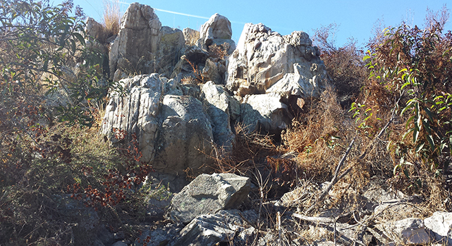
From this junction, turn left (south) once more, pass through a metal gate, and emerge from tree cover to a more open landscape. Many native species of coastal sage scrub habitat are abundant here, including broom baccharis, goldenbush, flattop buckwheat, white and black sage, California sagebrush, and laurel sumac. Pass behind more houses and reach the access point at Wieghorst Way after .75 mile from the start, marked by a California Riding and Hiking Trail signpost. From here, turn around, retrace your steps to about 90 yards before the metal gate, and spot an obscure use trail on the left. To add a little elevation gain on this walk, turn uphill on this somewhat overgrown path as it winds its way west through low shrubs and over rocks to the high point of the park at 738 feet and near the edge of a fenced private-property boundary. Enjoy the wide-sweeping views of El Cajon Mountain, Viejas Mountain, Bell Bluff, McGinty Mountain, Lyons Peak, and San Miguel Mountain. Retrace your steps down to the main trail.
Continue north on the main trail, once again going through the metal gate and bypassing the paths coming up from the creek. At just under 1.5 miles, reach a split — the trail to the right crosses a low spot and later rejoins the outer trail — stay left to skirt the western edge of the park for a slightly longer option. Note the variety of plants in this area: willows, mule fat, tree tobacco, palm trees, pepper trees, and castor bean growing in or near the riparian corridor, with horehound, sages, toyon, California sagebrush, and the large amount of broom baccharis in the drier, open areas.
Cross a small wooden bridge and reach the northwest corner of the park around 1.7 miles. Here is where Damon Lane comes into view, another access point. Continue curving right, heading east, passing through one more shady area with palm and pepper trees overhead as well as stands of olive trees. You’ll approach the close of the loop at around 2 miles, where you will spot the trailhead gate and where your vehicle awaits.
Hidden slice of riparian habitat in the midst of suburbia.
Distance from downtown San Diego: 15.5 miles (Rancho San Diego). Allow 25 minutes driving time. From downtown San Diego, take State Route 94 east into Casa de Oro and just as the divided highway ends, turn left at the signal for Via Mercado. Go 0.2 mile and turn right onto Calle Verde. Drive 0.3 mile and make another right onto Fury Lane. After 0.8 mile, turn left onto Wieghorst Way. Go 0.6 mile, turn left onto Calle Albara, and go a final 0.4 mile to the end of the road and park in the cul-de-sac.
No facilities.
Hiking length: 2-mile loop, add another half mile if exploring side trails.
Difficulty: Easy (moderate if climbing to the high point). Elevation gain/loss up to 150 feet. The trails are open to hikers, horses, leashed dogs, and mountain bikes. Park hours are from sunrise to sunset, daily.