Here's something you might be interested in.
Ask a Hipster — Advice you didn't know you needed
Big Screen — Movie commentary
Blurt — Music's inside track
Booze News — San Diego spirits
Classical Music — Immortal beauty
Classifieds — Free and easy
Cover Stories — Front-page features
Drinks All Around — Bartenders' drink recipes
Excerpts — Literary and spiritual excerpts
Feast! — Food & drink reviews
Feature Stories — Local news & stories
Fishing Report — What’s getting hooked from ship and shore
From the Archives — Spotlight on the past
Golden Dreams — Talk of the town
The Gonzo Report — Making the musical scene, or at least reporting from it
Letters — Our inbox
Movies@Home — Local movie buffs share favorites
Movie Reviews — Our critics' picks and pans
Musician Interviews — Up close with local artists
Neighborhood News from Stringers — Hyperlocal news
News Ticker — News & politics
Obermeyer — San Diego politics illustrated
Outdoors — Weekly changes in flora and fauna
Overheard in San Diego — Eavesdropping illustrated
Poetry — The old and the new
Reader Travel — Travel section built by travelers
Reading — The hunt for intellectuals
Roam-O-Rama — SoCal's best hiking/biking trails
San Diego Beer — Inside San Diego suds
SD on the QT — Almost factual news
Sheep and Goats — Places of worship
Special Issues — The best of
Street Style — San Diego streets have style
Surf Diego — Real stories from those braving the waves
Theater — On stage in San Diego this week
Tin Fork — Silver spoon alternative
Under the Radar — Matt Potter's undercover work
Unforgettable — Long-ago San Diego
Unreal Estate — San Diego's priciest pads
Your Week — Daily event picks
All this for roofing granules, poultry grit
Hike to West Dolomite Mine Peak to see interesting damage in the Coyote Mountains
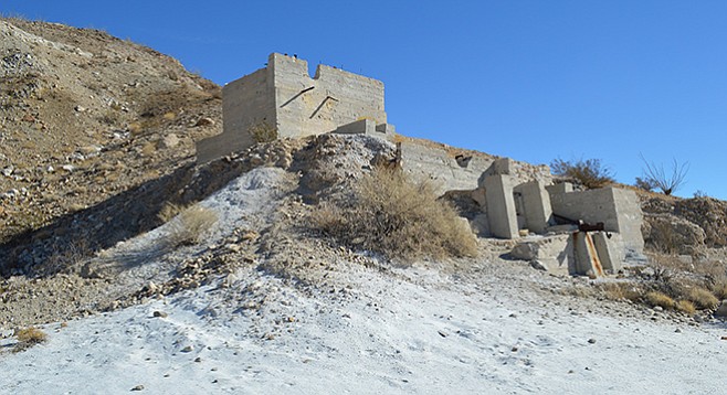
Ruins of the mine rock crusher
The main feature of this hike is the mine and its ruins, which is interesting to explore. It is a prime example of an open-pit strip mine (now closed off). The owners, Fred Elliott, Mrs. Ellen Elliott, and others, worked the mine from 1951–’53.
In places the trail is nonexistent.
They quarried several thousand tons of dolomite to use as roofing rock and hauled the rock to the nearest loading station 8 miles south at the San Diego & Arizona Eastern Railroad siding at Dos Cabezas. The ruins include the main rock crusher building with loading area and a small mysterious open square stone structure to the right of the crusher in a small canyon with a matching structure at the bottom of the canyon.
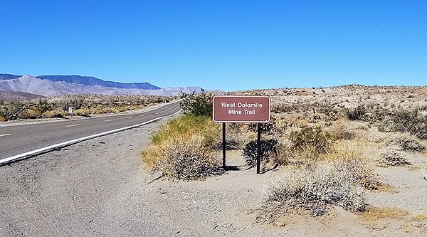
Mine entrance
The trail begins at S-2 with an easy walk through a sparse desert-floor habitat of cholla, creosote bush, and the occasional ocotillo. Desert agave, barrel cactus, and cheesebush are interspersed with lots of teddy-bear and Gander’s cholla. At the 0.75-mile mark, the road becomes a 4-wheel-drive road that is rutted and tough, ascending to the mine ruins.
The difficult part of the climb starts at the right side of the building ruins. A road to the right of the rock crusher curves up to the top of the crusher, where it’s fun to ponder the workings of the mine. The trail above the mine has loose, fist-sized, sharp-edged gravel creating difficult footing, especially while descending. From here, the trail pitches up the mountainside, gaining 500 feet of elevation in 0.05 mile. This is a very challenging section of the hike through the higher areas where attempts were made to chip out dolomite. In places the trail is nonexistent.
This higher elevation provides a bird’s-eye view of the tremendous effort and damage that mining did to this mountain. It levels out at the main ridge of the Coyote Mountains above the mine where there is a marvelous 180-degree vista of the Carrizo Badlands and the Laguna Mountains. The view is particularly great at sunset. If you continue to the 1850-foot summit, look for the summit register. The best time to do this hike is late fall, winter, or early spring.
Dolomite is quite pretty. It is a sedimentary magnesium carbonate rock made up of the mineral dolomite, related to limestone and marble. It was used in the 1950s for roofing granules, poultry grit, decorative stone, additive to potting-soil mixes, and sometimes used when smelting iron. It’s fascinating to wonder how they actually mined it. You can see many spots on the mountain where it looks like they used rock axe or hammer and chisel to chip out different sized cuts in the mountain face.
West Dolomite Mine Peak
Explore a mining area and hike to a peak in the Coyote Mountains.
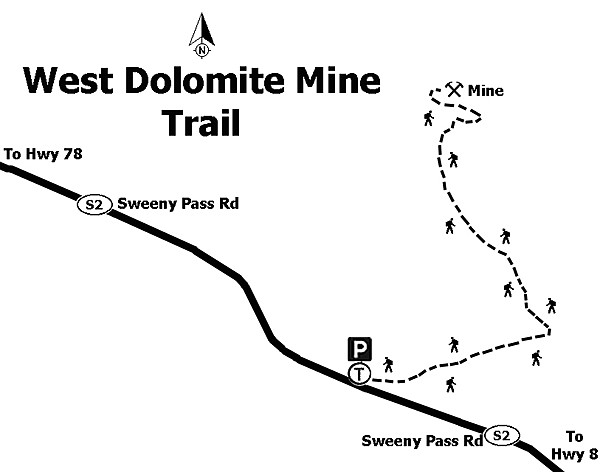
Distance from downtown San Diego: 99 miles. Allow 2 hours (Anza-Borrego Desert State Park). From SR-163N, take I-8E, exiting on the Imperial Hwy at Ocotillo after 88 miles. Turn left under the bridge to head northwest on Highway S-2 (the Great Overland Stage Route). Drive for 11 miles to the sign on the right for the West Dolomite Mine Trail and turn right. There are three parking options for 2-wheel and all-wheel drive: (1) Park on the east side of S-2 in a large dirt area with the Jojoba Wash sign. Cross S-2 to the Dolomite Mine Trailhead. (2) Drive 0.5 mile up the trail to where there is a parking and camping area on the left for about 8–10 cars and begin the hike from here. (3) Drive 0.75 mile up the trail past a big left turn in the road to a parking and camping area on the left for about 5–6 cars. After the third option, the road is recommended only for 4-wheel drive vehicles.
Hiking Length: 2.4 miles out-and-back following the third parking option above. Allow 2 hours.
Difficulty: Starts as an easy hike across the desert floor with the incline beginning at about 0.75 mile from S-2; then it becomes increasingly difficult en route to the top of Mine Peak. Elevation gain/loss 750 feet.
Here's something you might be interested in.
All this for roofing granules, poultry grit
Hike to West Dolomite Mine Peak to see interesting damage in the Coyote Mountains
All this for roofing granules, poultry grit
Hike to West Dolomite Mine Peak to see interesting damage in the Coyote Mountains
Ruins of the mine rock crusher
The main feature of this hike is the mine and its ruins, which is interesting to explore. It is a prime example of an open-pit strip mine (now closed off). The owners, Fred Elliott, Mrs. Ellen Elliott, and others, worked the mine from 1951–’53.
In places the trail is nonexistent.
They quarried several thousand tons of dolomite to use as roofing rock and hauled the rock to the nearest loading station 8 miles south at the San Diego & Arizona Eastern Railroad siding at Dos Cabezas. The ruins include the main rock crusher building with loading area and a small mysterious open square stone structure to the right of the crusher in a small canyon with a matching structure at the bottom of the canyon.
Mine entrance
The trail begins at S-2 with an easy walk through a sparse desert-floor habitat of cholla, creosote bush, and the occasional ocotillo. Desert agave, barrel cactus, and cheesebush are interspersed with lots of teddy-bear and Gander’s cholla. At the 0.75-mile mark, the road becomes a 4-wheel-drive road that is rutted and tough, ascending to the mine ruins.
The difficult part of the climb starts at the right side of the building ruins. A road to the right of the rock crusher curves up to the top of the crusher, where it’s fun to ponder the workings of the mine. The trail above the mine has loose, fist-sized, sharp-edged gravel creating difficult footing, especially while descending. From here, the trail pitches up the mountainside, gaining 500 feet of elevation in 0.05 mile. This is a very challenging section of the hike through the higher areas where attempts were made to chip out dolomite. In places the trail is nonexistent.
This higher elevation provides a bird’s-eye view of the tremendous effort and damage that mining did to this mountain. It levels out at the main ridge of the Coyote Mountains above the mine where there is a marvelous 180-degree vista of the Carrizo Badlands and the Laguna Mountains. The view is particularly great at sunset. If you continue to the 1850-foot summit, look for the summit register. The best time to do this hike is late fall, winter, or early spring.
Dolomite is quite pretty. It is a sedimentary magnesium carbonate rock made up of the mineral dolomite, related to limestone and marble. It was used in the 1950s for roofing granules, poultry grit, decorative stone, additive to potting-soil mixes, and sometimes used when smelting iron. It’s fascinating to wonder how they actually mined it. You can see many spots on the mountain where it looks like they used rock axe or hammer and chisel to chip out different sized cuts in the mountain face.
West Dolomite Mine Peak
Explore a mining area and hike to a peak in the Coyote Mountains.
Distance from downtown San Diego: 99 miles. Allow 2 hours (Anza-Borrego Desert State Park). From SR-163N, take I-8E, exiting on the Imperial Hwy at Ocotillo after 88 miles. Turn left under the bridge to head northwest on Highway S-2 (the Great Overland Stage Route). Drive for 11 miles to the sign on the right for the West Dolomite Mine Trail and turn right. There are three parking options for 2-wheel and all-wheel drive: (1) Park on the east side of S-2 in a large dirt area with the Jojoba Wash sign. Cross S-2 to the Dolomite Mine Trailhead. (2) Drive 0.5 mile up the trail to where there is a parking and camping area on the left for about 8–10 cars and begin the hike from here. (3) Drive 0.75 mile up the trail past a big left turn in the road to a parking and camping area on the left for about 5–6 cars. After the third option, the road is recommended only for 4-wheel drive vehicles.
Hiking Length: 2.4 miles out-and-back following the third parking option above. Allow 2 hours.
Difficulty: Starts as an easy hike across the desert floor with the incline beginning at about 0.75 mile from S-2; then it becomes increasingly difficult en route to the top of Mine Peak. Elevation gain/loss 750 feet.
Comments