Here's something you might be interested in.
Ask a Hipster — Advice you didn't know you needed
Big Screen — Movie commentary
Blurt — Music's inside track
Booze News — San Diego spirits
Classical Music — Immortal beauty
Classifieds — Free and easy
Cover Stories — Front-page features
Drinks All Around — Bartenders' drink recipes
Excerpts — Literary and spiritual excerpts
Feast! — Food & drink reviews
Feature Stories — Local news & stories
Fishing Report — What’s getting hooked from ship and shore
From the Archives — Spotlight on the past
Golden Dreams — Talk of the town
The Gonzo Report — Making the musical scene, or at least reporting from it
Letters — Our inbox
Movies@Home — Local movie buffs share favorites
Movie Reviews — Our critics' picks and pans
Musician Interviews — Up close with local artists
Neighborhood News from Stringers — Hyperlocal news
News Ticker — News & politics
Obermeyer — San Diego politics illustrated
Outdoors — Weekly changes in flora and fauna
Overheard in San Diego — Eavesdropping illustrated
Poetry — The old and the new
Reader Travel — Travel section built by travelers
Reading — The hunt for intellectuals
Roam-O-Rama — SoCal's best hiking/biking trails
San Diego Beer — Inside San Diego suds
SD on the QT — Almost factual news
Sheep and Goats — Places of worship
Special Issues — The best of
Street Style — San Diego streets have style
Surf Diego — Real stories from those braving the waves
Theater — On stage in San Diego this week
Tin Fork — Silver spoon alternative
Under the Radar — Matt Potter's undercover work
Unforgettable — Long-ago San Diego
Unreal Estate — San Diego's priciest pads
Your Week — Daily event picks
Loveland Reservoir: backcountry in San Diego's backyard
Just 45 minutes from downtown, the reservoir offers hiking, fishing and close-to-home wilderness.
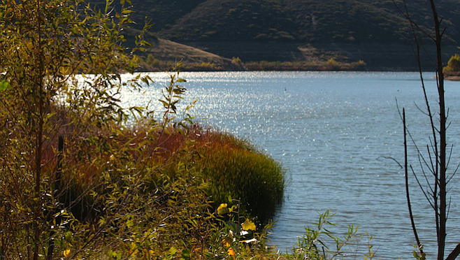
Lakefront shot on the Loveland Reservoir Trail, a 1.1 mile out and back hike near Alpine.
Loveland Lake and Dam is a true hidden gem in the backcountry about 40 minutes drive from downtown San Diego off I-8 East. The trailhead can be easily missed if you blink once while driving down on Japatul Road toward the Carveacre Wind Caves and Gaskill Peak, which are the two most popular hiking trails in Alpine.
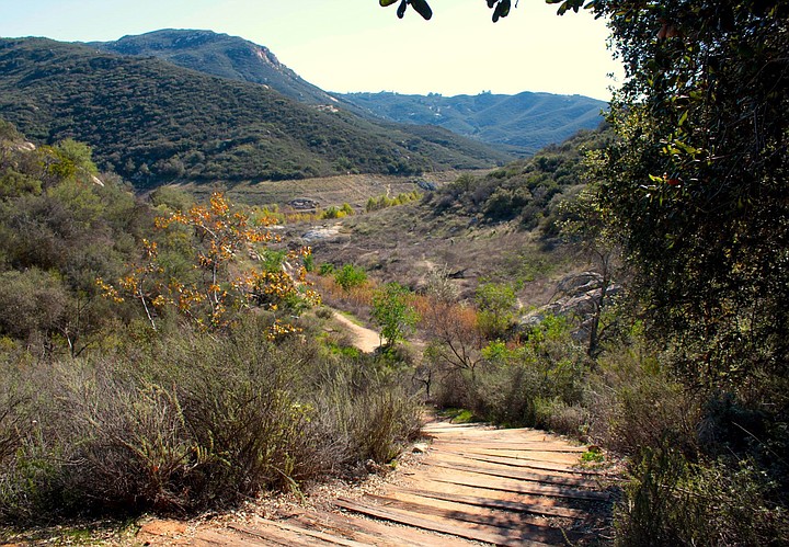
The start of the Loveland Reservoir hike.
The good news about not being a popular spot is that is almost deserted, and you can experience raw wilderness at its finest. The bad news about not being a popular spot is that… it is almost deserted — which means poor cell phone connection, light traffic on the main road and nobody to hear you screaming for help if you need to scream for help. Although the hike is not very strenuous and you can see the lake from the road (ok, two miles down), it’s better to be prepared with proper gear. Bringing enough water is mandatory, especially during the very hot summer we've been experiencing lately. Keep in mind, hiking in 100 degrees temperatures is not recommended. Go very early in the morning or wait for better days. The area is equally beautiful in the fall when the air starts cooling.
What to do: fishing and hiking
The lake is mainly a water reservoir owned by the Sweetwater Authority, who partnered up with the USDA Forest Services 19 years ago to provide public access to the lake. The rangers maintain the area, and only the first part of the trail is marked. There is no fee for fishing, but a California State Fishing License is required.
Due to the infestation with quagga mussels, live bait is not allowed and neither is swimming or boating. Animals are not permitted, not even service dogs. If you’re not discouraged by so many restrictions and still believe that hiking to the dam or trying your luck on the five-mile shoreline to fish at Loveland is a good idea, here’s a list with the fish you could catch: Largemouth Bass, Bullhead Catfish, Red Eared Sunfish, Crappie and Bluegill. Good enough.
The entrance gate leads to a spacious but rocky parking lot that opens at sunrise and closes at 6 p.m. with the specification that any car left behind will be towed. No port-a-potty available at the trailhead, but there are some at the lake.
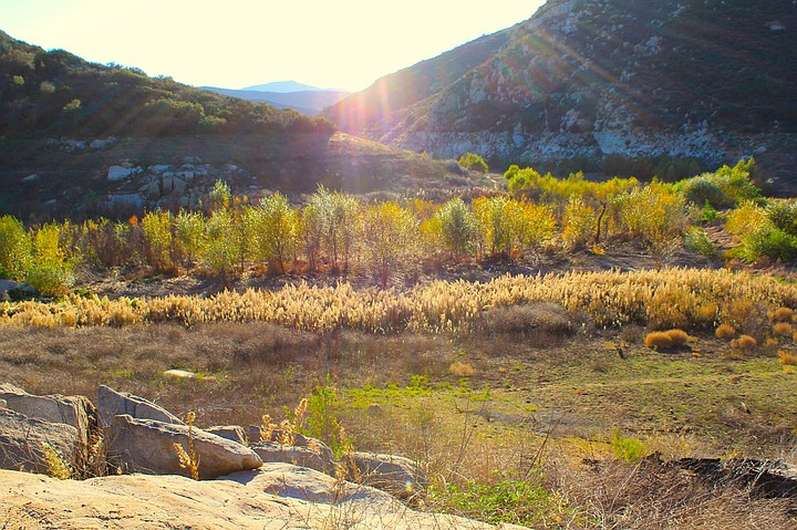
Chaparral view from the trail.
The location of the few port-a-potties provided around the lake is rather strange. They are all installed way up the hill and there’s no direct trail to any of them. You just have to make do through the stingy nettles and shrubbery. The main trail debuts in an encouraging way though, looking well maintained and well marked with added rails for support. It takes you down the hill rather fast, and for that hiking poles may be a good idea to protect your knees. The landscape is inviting enough that you may want to take a break just half a mile down the path to admire the thick forest and the blooming chamise, but mainly to enjoy the only shaded spot for miles around.
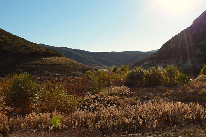
Spotting the lake in the distance.
Now you're ready to descend the 92 stairs to the bottom of the canyon. Although the hike is rated easy and considered mainly a path for fishing, there are hikers who believe the stairs make this trail an intermediate hike for people with mobility problems and a no go for hikers in wheelchair. Keep the stairs in mind then, both ways.
Once at the bottom, say good-bye to natural shade and hello to your hat, sunscreen and lots of water. From now on, there are only chaparral, sumacs, sage, buckwheat and thick grass to shade your feet only. To top it off, this is the end of the well-marked trail and machetes are not allowed. You kind of feel your way around by spotting the lake straight ahead and taking the path of least resistance, and that’s the one without the stinging nettles, if you can find it. Long pants and good, waterproof hiking boots are highly recommended, along with a good balance for the rocky terrain.
During the drought, crossing the lake on the east side is treacherous through thick cattails and marsh. The same vegetation is happening on the west trail, making hiking on the muddy shoreline rather difficult. This may be the main reason why Loveland Lake is not perceived as a hiking spot per se, but more of a fishing destination. After all, you want to experience backcountry: here it is in its entire splendor, with kingfishers on the rocks and redwing blackbirds chirping in the cattail, pelicans and herons winging it on the lake, all offering you an experience to make your courageous trip worthwhile.
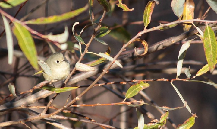
The endangered least Bell's vireo.
I even spotted the precious least Bell’s vireo, an endangered species, and I have a picture to prove it.
There are multiple other options for hiking, but mainly on the trails up the hills and toward the dam. Speaking of the dam, it’s a relatively new construction from 1945 and helps store over 25,300 acre-feet of water serving 175,000 residents of Bonita, Chula Vista and National City.
I hiked this trail twice. Once a couple of weeks ago very early in the morning, before that in November, and I prefer the wintertime better.
I will leave you with my personal entry in my hiking journal and then it’s up to you to decide if you're going to give Loveland a chance: “Loveland, Alpine, one of the nicest hikes ever, perfect in every way. Lots of very old oak trees and small, magic meadows, enchanting views over the lake and the surrounding areas, with Corte Madera in plain sight if you keep straight when you get to the lake. Yes, fishing, yes, birds, yes, rocks and yes, challenging trails. I even found metate. I loved the light filtered through the cattails and the colors of the grass and the clouds, but mostly the eerie peace. I will come back.”
Map
Loveland Reservoir
Loveland Reservoir
Here's something you might be interested in.
Loveland Reservoir: backcountry in San Diego's backyard
Just 45 minutes from downtown, the reservoir offers hiking, fishing and close-to-home wilderness.
Loveland Reservoir: backcountry in San Diego's backyard
Just 45 minutes from downtown, the reservoir offers hiking, fishing and close-to-home wilderness.
Lakefront shot on the Loveland Reservoir Trail, a 1.1 mile out and back hike near Alpine.
Loveland Lake and Dam is a true hidden gem in the backcountry about 40 minutes drive from downtown San Diego off I-8 East. The trailhead can be easily missed if you blink once while driving down on Japatul Road toward the Carveacre Wind Caves and Gaskill Peak, which are the two most popular hiking trails in Alpine.
The start of the Loveland Reservoir hike.
The good news about not being a popular spot is that is almost deserted, and you can experience raw wilderness at its finest. The bad news about not being a popular spot is that… it is almost deserted — which means poor cell phone connection, light traffic on the main road and nobody to hear you screaming for help if you need to scream for help. Although the hike is not very strenuous and you can see the lake from the road (ok, two miles down), it’s better to be prepared with proper gear. Bringing enough water is mandatory, especially during the very hot summer we've been experiencing lately. Keep in mind, hiking in 100 degrees temperatures is not recommended. Go very early in the morning or wait for better days. The area is equally beautiful in the fall when the air starts cooling.
What to do: fishing and hiking
The lake is mainly a water reservoir owned by the Sweetwater Authority, who partnered up with the USDA Forest Services 19 years ago to provide public access to the lake. The rangers maintain the area, and only the first part of the trail is marked. There is no fee for fishing, but a California State Fishing License is required.
Due to the infestation with quagga mussels, live bait is not allowed and neither is swimming or boating. Animals are not permitted, not even service dogs. If you’re not discouraged by so many restrictions and still believe that hiking to the dam or trying your luck on the five-mile shoreline to fish at Loveland is a good idea, here’s a list with the fish you could catch: Largemouth Bass, Bullhead Catfish, Red Eared Sunfish, Crappie and Bluegill. Good enough.
The entrance gate leads to a spacious but rocky parking lot that opens at sunrise and closes at 6 p.m. with the specification that any car left behind will be towed. No port-a-potty available at the trailhead, but there are some at the lake.
Chaparral view from the trail.
The location of the few port-a-potties provided around the lake is rather strange. They are all installed way up the hill and there’s no direct trail to any of them. You just have to make do through the stingy nettles and shrubbery. The main trail debuts in an encouraging way though, looking well maintained and well marked with added rails for support. It takes you down the hill rather fast, and for that hiking poles may be a good idea to protect your knees. The landscape is inviting enough that you may want to take a break just half a mile down the path to admire the thick forest and the blooming chamise, but mainly to enjoy the only shaded spot for miles around.
Spotting the lake in the distance.
Now you're ready to descend the 92 stairs to the bottom of the canyon. Although the hike is rated easy and considered mainly a path for fishing, there are hikers who believe the stairs make this trail an intermediate hike for people with mobility problems and a no go for hikers in wheelchair. Keep the stairs in mind then, both ways.
Once at the bottom, say good-bye to natural shade and hello to your hat, sunscreen and lots of water. From now on, there are only chaparral, sumacs, sage, buckwheat and thick grass to shade your feet only. To top it off, this is the end of the well-marked trail and machetes are not allowed. You kind of feel your way around by spotting the lake straight ahead and taking the path of least resistance, and that’s the one without the stinging nettles, if you can find it. Long pants and good, waterproof hiking boots are highly recommended, along with a good balance for the rocky terrain.
During the drought, crossing the lake on the east side is treacherous through thick cattails and marsh. The same vegetation is happening on the west trail, making hiking on the muddy shoreline rather difficult. This may be the main reason why Loveland Lake is not perceived as a hiking spot per se, but more of a fishing destination. After all, you want to experience backcountry: here it is in its entire splendor, with kingfishers on the rocks and redwing blackbirds chirping in the cattail, pelicans and herons winging it on the lake, all offering you an experience to make your courageous trip worthwhile.
The endangered least Bell's vireo.
I even spotted the precious least Bell’s vireo, an endangered species, and I have a picture to prove it.
There are multiple other options for hiking, but mainly on the trails up the hills and toward the dam. Speaking of the dam, it’s a relatively new construction from 1945 and helps store over 25,300 acre-feet of water serving 175,000 residents of Bonita, Chula Vista and National City.
I hiked this trail twice. Once a couple of weeks ago very early in the morning, before that in November, and I prefer the wintertime better.
I will leave you with my personal entry in my hiking journal and then it’s up to you to decide if you're going to give Loveland a chance: “Loveland, Alpine, one of the nicest hikes ever, perfect in every way. Lots of very old oak trees and small, magic meadows, enchanting views over the lake and the surrounding areas, with Corte Madera in plain sight if you keep straight when you get to the lake. Yes, fishing, yes, birds, yes, rocks and yes, challenging trails. I even found metate. I loved the light filtered through the cattails and the colors of the grass and the clouds, but mostly the eerie peace. I will come back.”
Map
Loveland Reservoir
Loveland Reservoir