Here's something you might be interested in.
Ask a Hipster — Advice you didn't know you needed
Big Screen — Movie commentary
Blurt — Music's inside track
Booze News — San Diego spirits
Classical Music — Immortal beauty
Classifieds — Free and easy
Cover Stories — Front-page features
Drinks All Around — Bartenders' drink recipes
Excerpts — Literary and spiritual excerpts
Feast! — Food & drink reviews
Feature Stories — Local news & stories
Fishing Report — What’s getting hooked from ship and shore
From the Archives — Spotlight on the past
Golden Dreams — Talk of the town
The Gonzo Report — Making the musical scene, or at least reporting from it
Letters — Our inbox
Movies@Home — Local movie buffs share favorites
Movie Reviews — Our critics' picks and pans
Musician Interviews — Up close with local artists
Neighborhood News from Stringers — Hyperlocal news
News Ticker — News & politics
Obermeyer — San Diego politics illustrated
Outdoors — Weekly changes in flora and fauna
Overheard in San Diego — Eavesdropping illustrated
Poetry — The old and the new
Reader Travel — Travel section built by travelers
Reading — The hunt for intellectuals
Roam-O-Rama — SoCal's best hiking/biking trails
San Diego Beer — Inside San Diego suds
SD on the QT — Almost factual news
Sheep and Goats — Places of worship
Special Issues — The best of
Street Style — San Diego streets have style
Surf Diego — Real stories from those braving the waves
Theater — On stage in San Diego this week
Tin Fork — Silver spoon alternative
Under the Radar — Matt Potter's undercover work
Unforgettable — Long-ago San Diego
Unreal Estate — San Diego's priciest pads
Your Week — Daily event picks
Zion & Bryce: a Utah national parks tour
Tips for hiking the Narrows, the Subway and more in this Reader travel guide.
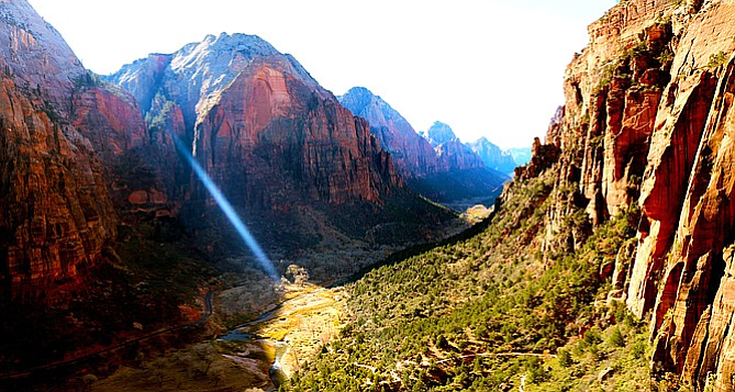
Angel's Landing might be "one of the most dangerous hikes in the United States" — still, you've got to see the view for yourself.
I had never been to Utah before this trip, so I wasn’t sure what to expect.
Ranches, cowboys, Mormons?
Southern Utah is canyons and valleys, red sandstone rocks and landscapes that Dr. Seuss would find unique.
Camping
We stayed at the Watchman Campground, which is located right inside the gates of the south entrance to Zion National Park. The campgrounds fill up quickly in the warmer months and should be reserved months in advance.
The Watchman is nestled right against a shopping center with coffeeshop, grocery store, the Zion Outfitters store and the Visitors Center where you can catch the shuttle. It is adjacent to the town of Springdale, which has plenty of shops and restaurants to explore between your adventuring.
Getting around
Zion National Park offers a free shuttle, running about every fifteen minutes, which take visitors to all of the hiking stops along Zion Canyon Scenic Drive. Driving is discouraged; cars are only allowed with an additional permit.
As we learned, the shuttle does not run all year long. Winter hours for the shuttle begin the Sunday after Thanksgiving and run through February. During warmer months, the shuttle operates through Springdale as well.
The views from the shuttle bus along Zion Mount Carmel Highway are pretty impressive. Bold and dramatic sweeping views of the canyon loom above, and every stop is a memorable hike just waiting for you. There are striking vantage points for all levels: Court of the Patriarchs, The Grotto, Weeping Rock, and the Temple of the Sinawava. The canyon runs for fifteen miles and reaches an elevation close to 9,000 feet. The area cover 146,597 acres; that’s 229 square miles.
The Narrows
The Narrows, which was featured on National Geographic’s America’s Best 100 Adventure, is through the Virgin River. It's the narrowest canyon in Zion Canyon at only 20 feet wide and canyon walls over 1,000 feet high. It can be done as a day hike or overnight backpacking trek.
For the camping option, the “top down” route, you need need to obtain a permit months in advance.
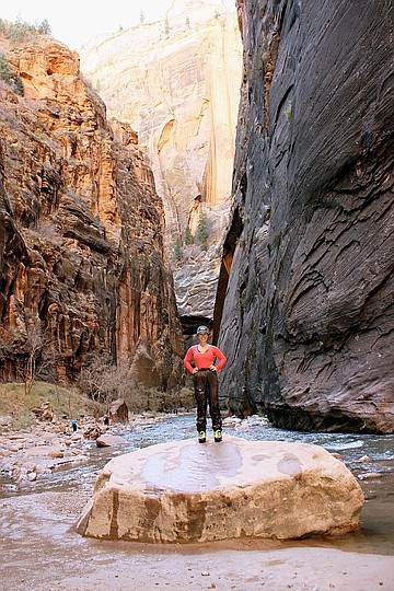
Zion's The Narrows hike.
We pursued The Narrows as a day hike, opting for the “bottom up”’ route. You should be mindful of the time of year you attempt this hike. The Narrows is typically closed between mid-March to late May from spring runoff. You should also definitely check the weather conditions prior to going. This is a serious flash flood zone; they can occur quickly and are very dangerous.
The Narrows can be found at the final stop on the park shuttle, Temple of Sinawava, and at the end of the Riverside Walk paved path which ends at the banks of the Virgin River. This is one of the most popular hikes in Zion and one of the best slot canyon hikes in the world. You will hear the crowds as you approach.
The water of the Virgin River was chilly. Neoprene socks, shoe rental and water pants is highly advised. We got ours at Zion Outfitters.
We passed a handful of people who were ill equipped with jeans and sneakers. There is no way you’re doing this hike, in November, without the proper gear. The water is cold and pretty deep in some places, and the rocks are slippery. Do yourself a favor and rent the canyoneering shoes, neoprene socks and wet pants. The gear kept us warm and dry, and helped to make this adventure a lot of fun.
The canyons are really gorgeous, but you can’t walk and look up for too long. This hike requires your full attention on where you're walking. The river is crowded in the beginning, but the farther upstream you venture the less people there will be. With each bend in the river, the narrower the canyon becomes and the faster the current. The water varies in places from ankle to waist deep. You will travel over rocks and small waterfalls. The sunlight illuminating the sides of the orange canyon walls, while in other places allowing only a sliver of light.
While you are in the water a lot of the time, there are respites along the banks of the river allowing you to walk on solid ground. The hike was an out and back, so the distance you went is up to you. We hiked three miles in, reaching Wall Street, sat atop rocks and ate lunch. Just beyond where we decided to call it quits, the water was reaching people’s chest. On the trek back you are moving with the current of the river, which I actually found more difficult.
The Narrows is the quintessential Zion hike. It’s simply stunning — and pretty amazing to be miles up a river between towering canyon walls walking along a flowing river, the canyon unveiling itself around each bend. A very cool experience. The trek was about six miles, but with the complexity of hiking in a river bed, we wrapped this hike at about four hours.
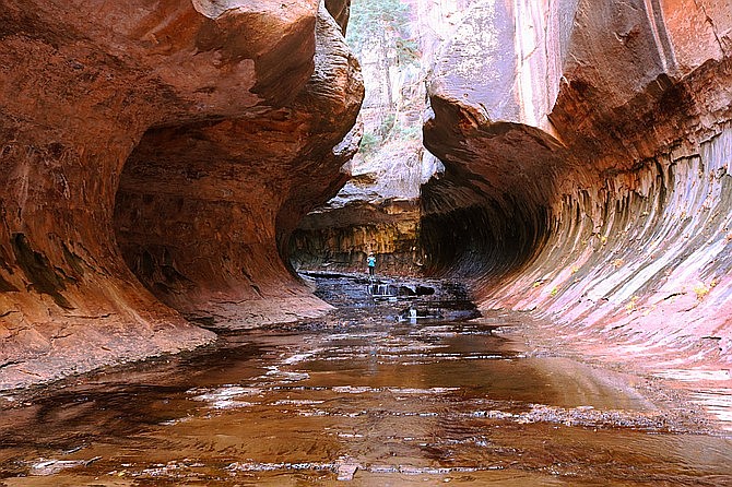
Entering The Subway.
The Subway
The Subway is outside of Zion National Park on Kolob Terrace Road in the town of Virgin. You need to obtain a permit to hike The Subway. In the busier months the parks are busier and permits much more competitive, necessitating a lottery. During the winter months, it’s easier to obtain.
Also note you'll need to pick up the permit in the park at the visitors center prior to the hike, so plan ahead.
The Subway is similar to The Narrows in that you can hike it in two ways, you need to be prepared for flash floods, and renting the water gear is advised. The Subway can be done from the top down or bottom up.
The top-down route is a 10-mile rappelling trek which can take an entire day or more depending on experience level.
We experienced The Subway from the bottom up, which is a 6½ out and back hike. After a mild half mile hike from the parking lot at the North Fork Trailhead, you’ll reach a steep descent into the canyon. After the canyon, around the ½ mark there are dinosaur tracks cemented in gray mudstone. They’re not marked, and we didn’t happen upon them, but the internet tells me they exist.
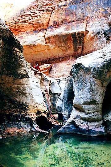
Canyoneers entering The Subway from the top down route.
Don't be afraid to get wet. Early in the trail you will find a distinguishable path carved out, but the further you go the more it just becomes following and walking in the river. You can zig zag along the banks, through the river, up over rocks, choosing your own path. The contrast of red rocks against a bright Utah sky and autumn colored leaves is lovely scenery as you hike on.
About two miles in you'll begin to see why this is such a notable hike. The river opens up to cascades, waterfalls, dramatic rock shelves. Many spots we passed looked ideal for swimming in the warmer months.
As you approach The Subway the canyon will begin to take on a dramatic tubular shape. The cavernous entrance opens to the small pools of emerald swirling water, a magical little portion of canyon. This is the turnaround spot of the hike, but also where the top-down canyoneers propel into. You will exit the same way you entered, that steep canyon. It is not well marked, so keep an eye out. It can easily be missed.
Hikers ascending Angels Landing.
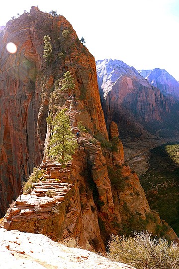
Angels Landing
Called one of the most dangerous hikes in the United States by Mens Journal and Outside Magazine, Angels Landing is the most popular in Zion. People have died on this trail. That fact is mentioned frequently: over the PA system on the shuttle, on signs along the trail, in the recommended search offered up by Google. It is 5½ miles out and back — a strenuous hike with an elevation gain of 1,500 feet.
We got started early, getting in line to the shuttle at about 7 a.m. We were not the only visitors who had gotten the memo to hit it early. Many were in line when we arrived. The trail is notoriously narrow at the top, with many anxiety-inducing portions of one-way-only traffic and a chain to grasp for security.
Angels Landing is at the 6th shuttle stop, The Grotto, and can be found across the street from the drop-off point. The first two miles of the hike is on the West Rim Trail. It is a steady uphill climb on a wide, paved trail. After a steady, uphill slog, the trail enters Refrigerator Canyon, where you will find a respite from the beating sun.
The Wiggles at Angels Landing.
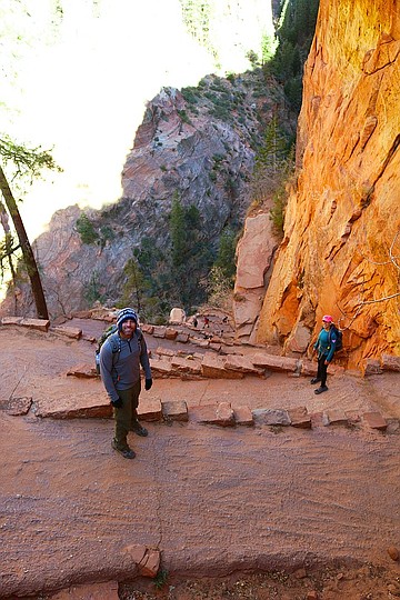
When you hit Walter’s Wiggles you will know you’re getting closer. Named after Walter Ruesch, Zion National Park’s first superintendent who constructed it in 1926, the Wiggles are a 21-switchback climb to the final push of the trail. How they constructed this nearly 100 years ago, i have no idea. At the top of Walter’s Wiggles is Scouts Lookout. From here, we had our first view of the trail along the ridge. People stopped off here, contemplating the continued precarious climb.
I'm still surprised that they let regular people do this hike — it's that intense. Heart thumping, knees wobbling, hands sweating intense. I mean, you are up there, high, high up there. In many sections there are steep drops on either side, a narrow, rocky trail in front, and just a chain to cling to, protecting you from falling to your death.
Zion’s website shows an older woman, a grandma, climbing to the top of the landing, grasping the chain bolted into the rock, mocking me from my internet browser. While preparing for our Zion trip I thought this would be easy peasy. Ethel over here is doing it in her velcro sneakers. But it was scary. The views are worth the effort — and the repeated mental affirmations that I will be ok, I will survive this hike.
On the way back down the trail got increasingly hotter from the rising sun and more crowded.
People become less patient on precarious single entry paths, only to reinforce my initial thought to go early and get there before everyone else. It really makes for a more enjoyable hike, as the canyon wakes up and the views are all your own, no selfies to contend with. In total Angels Landing took us about four hours, from shuttle ride in to shuttle ride out. Leaving us with our afternoon to take on Bryce Canyon!
Bryce Canyon
The hour and half drive along Scenic Byway 12, which has been called the second-most scenic drive in the country by Car and Driver Magazine, takes you from Zion National Park to Bryce Canyon. It’s a beautiful drive past open plains, canyons, small towns and, if you’re lucky, mountain goats.
Once inside Bryce Canyon National Parks, the viewpoints are on the 18-mile road that sits along the rim of the canyon. There are a series of overlooks and trails along the top of the rim. Since we were visiting in the offseason, the crowds were scarce, but I imagine in the summer months that this park could get very busy.
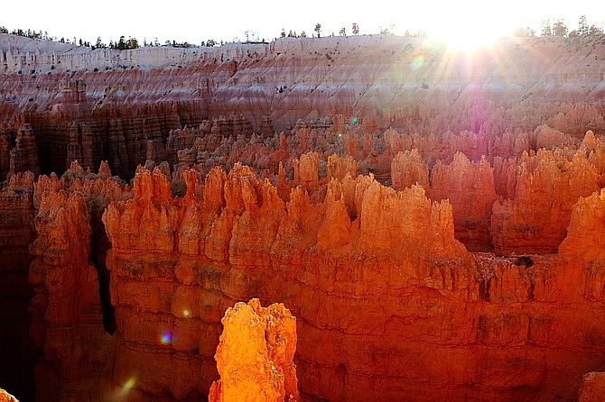
It is a stark contrast in landscape to the sheer cliffs of Zion. Jagged hoodoo rise from Bryce’s canyon floor. Carved by wind and water of millions of years, these hoodoos feel Dr. Suessian in their nature. Whimsical, like they belong in another world, a fairytale, and not here in Utah. I suppose this is the universal feeling, as there is a trail named Fairyland Loop.
Sun setting on Bryce Canyon.
From Sunrise Point, we descended into the canyon to Queens Garden Loop and followed out the Navajo Trail through the winding amphitheater, ending at the famous Sunset Point just in time for sunset. As the sun set, the shadows shifted and painted new color combinations along the ridges of the hoodoos.
Bryce far exceeded my expectations, and I would love to come back someday to spend more time discovering this park.
In total, we only spent about five hours here, making the drive back along the winding road to Zion in the dark. We left for home early the next morning, before the sun rose, in an attempt to beat the Las Vegas traffic.
Utah, like Arizona and Nevada, hold so many hidden gems. So much exploring to dig into. I would recommend checking out Zion and Bryce in the winter months. We beat the crowds and were not subject to the oppressive heat that the summer season comes with. The temperatures were mild and enjoyable, and the trails were uncongested. We did prepare for cold temperatures at night, but lucked out and experienced unseasonably moderate weather.
Here's something you might be interested in.
Zion & Bryce: a Utah national parks tour
Tips for hiking the Narrows, the Subway and more in this Reader travel guide.
Zion & Bryce: a Utah national parks tour
Tips for hiking the Narrows, the Subway and more in this Reader travel guide.
Angel's Landing might be "one of the most dangerous hikes in the United States" — still, you've got to see the view for yourself.
I had never been to Utah before this trip, so I wasn’t sure what to expect.
Ranches, cowboys, Mormons?
Southern Utah is canyons and valleys, red sandstone rocks and landscapes that Dr. Seuss would find unique.
Camping
We stayed at the Watchman Campground, which is located right inside the gates of the south entrance to Zion National Park. The campgrounds fill up quickly in the warmer months and should be reserved months in advance.
The Watchman is nestled right against a shopping center with coffeeshop, grocery store, the Zion Outfitters store and the Visitors Center where you can catch the shuttle. It is adjacent to the town of Springdale, which has plenty of shops and restaurants to explore between your adventuring.
Getting around
Zion National Park offers a free shuttle, running about every fifteen minutes, which take visitors to all of the hiking stops along Zion Canyon Scenic Drive. Driving is discouraged; cars are only allowed with an additional permit.
As we learned, the shuttle does not run all year long. Winter hours for the shuttle begin the Sunday after Thanksgiving and run through February. During warmer months, the shuttle operates through Springdale as well.
The views from the shuttle bus along Zion Mount Carmel Highway are pretty impressive. Bold and dramatic sweeping views of the canyon loom above, and every stop is a memorable hike just waiting for you. There are striking vantage points for all levels: Court of the Patriarchs, The Grotto, Weeping Rock, and the Temple of the Sinawava. The canyon runs for fifteen miles and reaches an elevation close to 9,000 feet. The area cover 146,597 acres; that’s 229 square miles.
The Narrows
The Narrows, which was featured on National Geographic’s America’s Best 100 Adventure, is through the Virgin River. It's the narrowest canyon in Zion Canyon at only 20 feet wide and canyon walls over 1,000 feet high. It can be done as a day hike or overnight backpacking trek.
For the camping option, the “top down” route, you need need to obtain a permit months in advance.
Zion's The Narrows hike.
We pursued The Narrows as a day hike, opting for the “bottom up”’ route. You should be mindful of the time of year you attempt this hike. The Narrows is typically closed between mid-March to late May from spring runoff. You should also definitely check the weather conditions prior to going. This is a serious flash flood zone; they can occur quickly and are very dangerous.
The Narrows can be found at the final stop on the park shuttle, Temple of Sinawava, and at the end of the Riverside Walk paved path which ends at the banks of the Virgin River. This is one of the most popular hikes in Zion and one of the best slot canyon hikes in the world. You will hear the crowds as you approach.
The water of the Virgin River was chilly. Neoprene socks, shoe rental and water pants is highly advised. We got ours at Zion Outfitters.
We passed a handful of people who were ill equipped with jeans and sneakers. There is no way you’re doing this hike, in November, without the proper gear. The water is cold and pretty deep in some places, and the rocks are slippery. Do yourself a favor and rent the canyoneering shoes, neoprene socks and wet pants. The gear kept us warm and dry, and helped to make this adventure a lot of fun.
The canyons are really gorgeous, but you can’t walk and look up for too long. This hike requires your full attention on where you're walking. The river is crowded in the beginning, but the farther upstream you venture the less people there will be. With each bend in the river, the narrower the canyon becomes and the faster the current. The water varies in places from ankle to waist deep. You will travel over rocks and small waterfalls. The sunlight illuminating the sides of the orange canyon walls, while in other places allowing only a sliver of light.
While you are in the water a lot of the time, there are respites along the banks of the river allowing you to walk on solid ground. The hike was an out and back, so the distance you went is up to you. We hiked three miles in, reaching Wall Street, sat atop rocks and ate lunch. Just beyond where we decided to call it quits, the water was reaching people’s chest. On the trek back you are moving with the current of the river, which I actually found more difficult.
The Narrows is the quintessential Zion hike. It’s simply stunning — and pretty amazing to be miles up a river between towering canyon walls walking along a flowing river, the canyon unveiling itself around each bend. A very cool experience. The trek was about six miles, but with the complexity of hiking in a river bed, we wrapped this hike at about four hours.
Entering The Subway.
The Subway
The Subway is outside of Zion National Park on Kolob Terrace Road in the town of Virgin. You need to obtain a permit to hike The Subway. In the busier months the parks are busier and permits much more competitive, necessitating a lottery. During the winter months, it’s easier to obtain.
Also note you'll need to pick up the permit in the park at the visitors center prior to the hike, so plan ahead.
The Subway is similar to The Narrows in that you can hike it in two ways, you need to be prepared for flash floods, and renting the water gear is advised. The Subway can be done from the top down or bottom up.
The top-down route is a 10-mile rappelling trek which can take an entire day or more depending on experience level.
We experienced The Subway from the bottom up, which is a 6½ out and back hike. After a mild half mile hike from the parking lot at the North Fork Trailhead, you’ll reach a steep descent into the canyon. After the canyon, around the ½ mark there are dinosaur tracks cemented in gray mudstone. They’re not marked, and we didn’t happen upon them, but the internet tells me they exist.
Canyoneers entering The Subway from the top down route.
Don't be afraid to get wet. Early in the trail you will find a distinguishable path carved out, but the further you go the more it just becomes following and walking in the river. You can zig zag along the banks, through the river, up over rocks, choosing your own path. The contrast of red rocks against a bright Utah sky and autumn colored leaves is lovely scenery as you hike on.
About two miles in you'll begin to see why this is such a notable hike. The river opens up to cascades, waterfalls, dramatic rock shelves. Many spots we passed looked ideal for swimming in the warmer months.
As you approach The Subway the canyon will begin to take on a dramatic tubular shape. The cavernous entrance opens to the small pools of emerald swirling water, a magical little portion of canyon. This is the turnaround spot of the hike, but also where the top-down canyoneers propel into. You will exit the same way you entered, that steep canyon. It is not well marked, so keep an eye out. It can easily be missed.
Hikers ascending Angels Landing.
Angels Landing
Called one of the most dangerous hikes in the United States by Mens Journal and Outside Magazine, Angels Landing is the most popular in Zion. People have died on this trail. That fact is mentioned frequently: over the PA system on the shuttle, on signs along the trail, in the recommended search offered up by Google. It is 5½ miles out and back — a strenuous hike with an elevation gain of 1,500 feet.
We got started early, getting in line to the shuttle at about 7 a.m. We were not the only visitors who had gotten the memo to hit it early. Many were in line when we arrived. The trail is notoriously narrow at the top, with many anxiety-inducing portions of one-way-only traffic and a chain to grasp for security.
Angels Landing is at the 6th shuttle stop, The Grotto, and can be found across the street from the drop-off point. The first two miles of the hike is on the West Rim Trail. It is a steady uphill climb on a wide, paved trail. After a steady, uphill slog, the trail enters Refrigerator Canyon, where you will find a respite from the beating sun.
The Wiggles at Angels Landing.
When you hit Walter’s Wiggles you will know you’re getting closer. Named after Walter Ruesch, Zion National Park’s first superintendent who constructed it in 1926, the Wiggles are a 21-switchback climb to the final push of the trail. How they constructed this nearly 100 years ago, i have no idea. At the top of Walter’s Wiggles is Scouts Lookout. From here, we had our first view of the trail along the ridge. People stopped off here, contemplating the continued precarious climb.
I'm still surprised that they let regular people do this hike — it's that intense. Heart thumping, knees wobbling, hands sweating intense. I mean, you are up there, high, high up there. In many sections there are steep drops on either side, a narrow, rocky trail in front, and just a chain to cling to, protecting you from falling to your death.
Zion’s website shows an older woman, a grandma, climbing to the top of the landing, grasping the chain bolted into the rock, mocking me from my internet browser. While preparing for our Zion trip I thought this would be easy peasy. Ethel over here is doing it in her velcro sneakers. But it was scary. The views are worth the effort — and the repeated mental affirmations that I will be ok, I will survive this hike.
On the way back down the trail got increasingly hotter from the rising sun and more crowded.
People become less patient on precarious single entry paths, only to reinforce my initial thought to go early and get there before everyone else. It really makes for a more enjoyable hike, as the canyon wakes up and the views are all your own, no selfies to contend with. In total Angels Landing took us about four hours, from shuttle ride in to shuttle ride out. Leaving us with our afternoon to take on Bryce Canyon!
Bryce Canyon
The hour and half drive along Scenic Byway 12, which has been called the second-most scenic drive in the country by Car and Driver Magazine, takes you from Zion National Park to Bryce Canyon. It’s a beautiful drive past open plains, canyons, small towns and, if you’re lucky, mountain goats.
Once inside Bryce Canyon National Parks, the viewpoints are on the 18-mile road that sits along the rim of the canyon. There are a series of overlooks and trails along the top of the rim. Since we were visiting in the offseason, the crowds were scarce, but I imagine in the summer months that this park could get very busy.
It is a stark contrast in landscape to the sheer cliffs of Zion. Jagged hoodoo rise from Bryce’s canyon floor. Carved by wind and water of millions of years, these hoodoos feel Dr. Suessian in their nature. Whimsical, like they belong in another world, a fairytale, and not here in Utah. I suppose this is the universal feeling, as there is a trail named Fairyland Loop.
Sun setting on Bryce Canyon.
From Sunrise Point, we descended into the canyon to Queens Garden Loop and followed out the Navajo Trail through the winding amphitheater, ending at the famous Sunset Point just in time for sunset. As the sun set, the shadows shifted and painted new color combinations along the ridges of the hoodoos.
Bryce far exceeded my expectations, and I would love to come back someday to spend more time discovering this park.
In total, we only spent about five hours here, making the drive back along the winding road to Zion in the dark. We left for home early the next morning, before the sun rose, in an attempt to beat the Las Vegas traffic.
Utah, like Arizona and Nevada, hold so many hidden gems. So much exploring to dig into. I would recommend checking out Zion and Bryce in the winter months. We beat the crowds and were not subject to the oppressive heat that the summer season comes with. The temperatures were mild and enjoyable, and the trails were uncongested. We did prepare for cold temperatures at night, but lucked out and experienced unseasonably moderate weather.
Comments