Here's something you might be interested in.
Ask a Hipster — Advice you didn't know you needed
Big Screen — Movie commentary
Blurt — Music's inside track
Booze News — San Diego spirits
Classical Music — Immortal beauty
Classifieds — Free and easy
Cover Stories — Front-page features
Drinks All Around — Bartenders' drink recipes
Excerpts — Literary and spiritual excerpts
Feast! — Food & drink reviews
Feature Stories — Local news & stories
Fishing Report — What’s getting hooked from ship and shore
From the Archives — Spotlight on the past
Golden Dreams — Talk of the town
The Gonzo Report — Making the musical scene, or at least reporting from it
Letters — Our inbox
Movies@Home — Local movie buffs share favorites
Movie Reviews — Our critics' picks and pans
Musician Interviews — Up close with local artists
Neighborhood News from Stringers — Hyperlocal news
News Ticker — News & politics
Obermeyer — San Diego politics illustrated
Outdoors — Weekly changes in flora and fauna
Overheard in San Diego — Eavesdropping illustrated
Poetry — The old and the new
Reader Travel — Travel section built by travelers
Reading — The hunt for intellectuals
Roam-O-Rama — SoCal's best hiking/biking trails
San Diego Beer — Inside San Diego suds
SD on the QT — Almost factual news
Sheep and Goats — Places of worship
Special Issues — The best of
Street Style — San Diego streets have style
Surf Diego — Real stories from those braving the waves
Theater — On stage in San Diego this week
Tin Fork — Silver spoon alternative
Under the Radar — Matt Potter's undercover work
Unforgettable — Long-ago San Diego
Unreal Estate — San Diego's priciest pads
Your Week — Daily event picks
Part of Cuyamaca spared by 2003 Cedar Fire
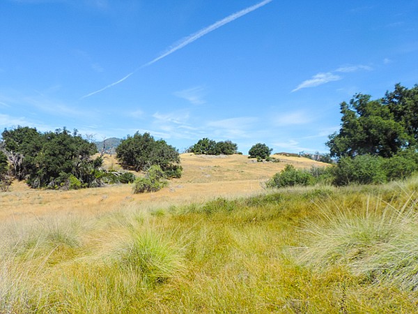
East Mesa's grassland is non-native
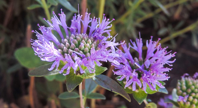
Mustang mint, an annual, grows up to 18˝ tall.
In 1923, wealthy Beverly Hills residents Ralph and Helen Dyar purchased 20,000 acres of the original 35,500-acre Rancho Cuyamaca Spanish land grant and built their summer home near what is now the Park’s Visitor Center and museum. Ten years later, the property was sold to the state, creating Cuyamaca Rancho State Park with the insistence that their ranch foreman, Harvey Moore, was to be the park’s first ranger.
In cold weather, ladybugs can be found in deer-grass clumps.
The Dyar home was the original park visitor center. Remnants of the home are near the new visitor center. The park is now approximately 26,000 acres and consists of protected wildlife habitat, watershed, archaeological sites, botanical reserve, and recreational land with roughly half of the park classified as wilderness area.
Be on the alert for mule deer and wild turkeys and, if lucky, spot a lone bobcat.
The name Cuyamaca is a Spanish corruption of the Kumeyaay phrase ekwiiyemak, which has been translated to mean “behind the clouds” or as “the place where it rains,” alluding to the higher-than-average rainfall experienced here as compared to the dryer coastal regions of the county. Much of the park, along with the Dyar home, was burned in the 2003 Cedar Fire, but sections of East Mesa, including Dyar Spring and Juaquapin Creek, were spared major damage. The hike described here tours many of the unique environments found in the park.
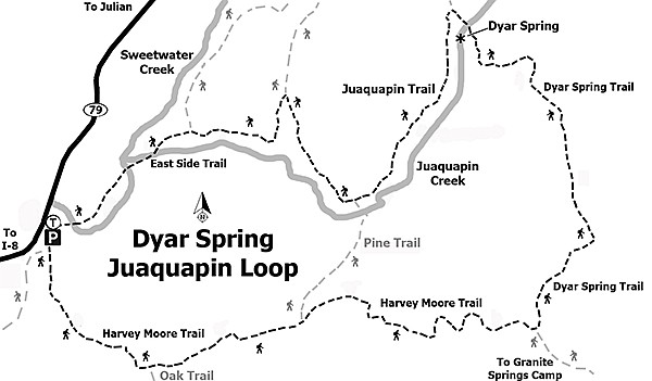
The Harvey Moore/East Side Trail trailhead is at the northeast end of the Sweetwater parking area. To the left is the East Side trail, which is the end of the 6-mile loop. To start the loop, take the path to the right on the Harvey Moore Trail and after about 0.1 mile pass the trail that parallels CA-79 to the next parking lot to the south. Continue on the Harvey Moore Trail and pass two T-intersections; the first after a mile is the Oak Trail to the south, and the second after 1.25 miles is the Pine Trail to the north. The trail starts out under the cover of oaks but will soon begins to ascend into a more open chaparral environment. Continue east and at 2.25 miles take the Dyar Spring Trail to the left (north). At this point, most of elevation gain is accomplished and the trail enters an area known as East Mesa, noted for a large expanse of open grassland dotted with oaks. Much of this grassland community is non-native California and ripgut brome, though there are areas of evergreen native deer grass that grow in scattered clumps. Be on the alert for mule deer and wild turkeys and, if lucky, spot a lone bobcat hunting in the tall grass. Dyar Spring is at 3.2 miles, marked by a small watering trough fed from a plastic pipe. While the water may look refreshing, it is not meant for human consumption. Just past the spring is a cluster of granitic rocks under the shade of some large coast live oaks, which is a pleasant spot to relax and have lunch or a snack.
Continue up and over a small ridge, then begin a slow descent toward Juaquapin Creek. At 3.8 miles, there is a saddle where you leave the Dyar Springs Trail and take the Juaquapin Trail to the left (south). At 4.6 miles, continue past the northern end of the Pine Trail and continue on the Juaquapin Trail. Before leaving the trail intersection, walk past the metal hitching post and look for a small flat rock with several Indian morteros that were used by the indigenous Kumeyaay to grind acorns from both the black and coast live oaks, which were once abundant here. Grinding produced fine acorn flour that was then washed with water to remove the acorn’s tannic acid. Once the tannic acid was removed, more water was added to the acorn meal to make a mush that was then cooked in a weaved basket by stirring hot rocks in the acorn mush until it was ready to eat. Shawee, as it is called, was a staple of the Kumeyaay diet in early years and is still enjoyed today.
Return to the trail and at 5 miles turn left to take the East Side Connector Trail down a shady ravine where you may hear the sounds of Juaquapin Creek as it flows to the Sweetwater Creek. At 5.5 miles, go left (south) on the East Side Trail. After a little more than 0.5 mile, the loop is completed at the Sweetwater parking area.
An option to reduce the loop by about 3 miles is to turn left (north) onto Pine Trail, then another left (west) just past the Juaquapin Creek and then left (south) onto the East Side Trail to the Sweetwater parking area.
Note: Small pieces of pottery may still be found around the morteros. It is against the law to remove any of these pieces — if you do pick one up, be sure to replace it exactly where you found it. The exact location of pottery shards is important to archaeologists who record Native American sites.
Distance from downtown San Diego: 47 miles (Cuyamaca Mountains). Allow 60 minutes driving time. From I-8, exit north onto CA-79 for 2.6 miles before turning. Turn left to continue on CA-79 for 4.9 miles to the large Sweetwater parking area on the right, just before the Sweetwater Bridge, one-half mile past the Green Valley Falls Campground. No facilities
Hiking length: Approximately a 6-mile loop.
Difficulty: Moderately strenuous with over 800 feet of elevation gain/loss.
Here's something you might be interested in.
Part of Cuyamaca spared by 2003 Cedar Fire
East Mesa's grassland is non-native
Part of Cuyamaca spared by 2003 Cedar Fire
East Mesa's grassland is non-native
Mustang mint, an annual, grows up to 18˝ tall.
In 1923, wealthy Beverly Hills residents Ralph and Helen Dyar purchased 20,000 acres of the original 35,500-acre Rancho Cuyamaca Spanish land grant and built their summer home near what is now the Park’s Visitor Center and museum. Ten years later, the property was sold to the state, creating Cuyamaca Rancho State Park with the insistence that their ranch foreman, Harvey Moore, was to be the park’s first ranger.
In cold weather, ladybugs can be found in deer-grass clumps.
The Dyar home was the original park visitor center. Remnants of the home are near the new visitor center. The park is now approximately 26,000 acres and consists of protected wildlife habitat, watershed, archaeological sites, botanical reserve, and recreational land with roughly half of the park classified as wilderness area.
Be on the alert for mule deer and wild turkeys and, if lucky, spot a lone bobcat.
The name Cuyamaca is a Spanish corruption of the Kumeyaay phrase ekwiiyemak, which has been translated to mean “behind the clouds” or as “the place where it rains,” alluding to the higher-than-average rainfall experienced here as compared to the dryer coastal regions of the county. Much of the park, along with the Dyar home, was burned in the 2003 Cedar Fire, but sections of East Mesa, including Dyar Spring and Juaquapin Creek, were spared major damage. The hike described here tours many of the unique environments found in the park.
The Harvey Moore/East Side Trail trailhead is at the northeast end of the Sweetwater parking area. To the left is the East Side trail, which is the end of the 6-mile loop. To start the loop, take the path to the right on the Harvey Moore Trail and after about 0.1 mile pass the trail that parallels CA-79 to the next parking lot to the south. Continue on the Harvey Moore Trail and pass two T-intersections; the first after a mile is the Oak Trail to the south, and the second after 1.25 miles is the Pine Trail to the north. The trail starts out under the cover of oaks but will soon begins to ascend into a more open chaparral environment. Continue east and at 2.25 miles take the Dyar Spring Trail to the left (north). At this point, most of elevation gain is accomplished and the trail enters an area known as East Mesa, noted for a large expanse of open grassland dotted with oaks. Much of this grassland community is non-native California and ripgut brome, though there are areas of evergreen native deer grass that grow in scattered clumps. Be on the alert for mule deer and wild turkeys and, if lucky, spot a lone bobcat hunting in the tall grass. Dyar Spring is at 3.2 miles, marked by a small watering trough fed from a plastic pipe. While the water may look refreshing, it is not meant for human consumption. Just past the spring is a cluster of granitic rocks under the shade of some large coast live oaks, which is a pleasant spot to relax and have lunch or a snack.
Continue up and over a small ridge, then begin a slow descent toward Juaquapin Creek. At 3.8 miles, there is a saddle where you leave the Dyar Springs Trail and take the Juaquapin Trail to the left (south). At 4.6 miles, continue past the northern end of the Pine Trail and continue on the Juaquapin Trail. Before leaving the trail intersection, walk past the metal hitching post and look for a small flat rock with several Indian morteros that were used by the indigenous Kumeyaay to grind acorns from both the black and coast live oaks, which were once abundant here. Grinding produced fine acorn flour that was then washed with water to remove the acorn’s tannic acid. Once the tannic acid was removed, more water was added to the acorn meal to make a mush that was then cooked in a weaved basket by stirring hot rocks in the acorn mush until it was ready to eat. Shawee, as it is called, was a staple of the Kumeyaay diet in early years and is still enjoyed today.
Return to the trail and at 5 miles turn left to take the East Side Connector Trail down a shady ravine where you may hear the sounds of Juaquapin Creek as it flows to the Sweetwater Creek. At 5.5 miles, go left (south) on the East Side Trail. After a little more than 0.5 mile, the loop is completed at the Sweetwater parking area.
An option to reduce the loop by about 3 miles is to turn left (north) onto Pine Trail, then another left (west) just past the Juaquapin Creek and then left (south) onto the East Side Trail to the Sweetwater parking area.
Note: Small pieces of pottery may still be found around the morteros. It is against the law to remove any of these pieces — if you do pick one up, be sure to replace it exactly where you found it. The exact location of pottery shards is important to archaeologists who record Native American sites.
Distance from downtown San Diego: 47 miles (Cuyamaca Mountains). Allow 60 minutes driving time. From I-8, exit north onto CA-79 for 2.6 miles before turning. Turn left to continue on CA-79 for 4.9 miles to the large Sweetwater parking area on the right, just before the Sweetwater Bridge, one-half mile past the Green Valley Falls Campground. No facilities
Hiking length: Approximately a 6-mile loop.
Difficulty: Moderately strenuous with over 800 feet of elevation gain/loss.
Comments