Here's something you might be interested in.
Ask a Hipster — Advice you didn't know you needed
Big Screen — Movie commentary
Blurt — Music's inside track
Booze News — San Diego spirits
Classical Music — Immortal beauty
Classifieds — Free and easy
Cover Stories — Front-page features
Drinks All Around — Bartenders' drink recipes
Excerpts — Literary and spiritual excerpts
Feast! — Food & drink reviews
Feature Stories — Local news & stories
Fishing Report — What’s getting hooked from ship and shore
From the Archives — Spotlight on the past
Golden Dreams — Talk of the town
The Gonzo Report — Making the musical scene, or at least reporting from it
Letters — Our inbox
Movies@Home — Local movie buffs share favorites
Movie Reviews — Our critics' picks and pans
Musician Interviews — Up close with local artists
Neighborhood News from Stringers — Hyperlocal news
News Ticker — News & politics
Obermeyer — San Diego politics illustrated
Outdoors — Weekly changes in flora and fauna
Overheard in San Diego — Eavesdropping illustrated
Poetry — The old and the new
Reader Travel — Travel section built by travelers
Reading — The hunt for intellectuals
Roam-O-Rama — SoCal's best hiking/biking trails
San Diego Beer — Inside San Diego suds
SD on the QT — Almost factual news
Sheep and Goats — Places of worship
Special Issues — The best of
Street Style — San Diego streets have style
Surf Diego — Real stories from those braving the waves
Theater — On stage in San Diego this week
Tin Fork — Silver spoon alternative
Under the Radar — Matt Potter's undercover work
Unforgettable — Long-ago San Diego
Unreal Estate — San Diego's priciest pads
Your Week — Daily event picks
No bay at Border Field State Park for about 7000 years
Explore a beach and estuary at the extreme southwest corner of the continental USA
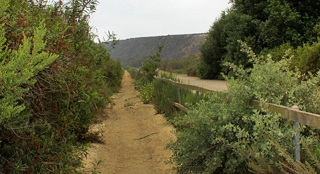
The trail leading to the beach
Border Field State Park is where delegations from both the U.S. and Mexico began the survey of the border in 1850 after the Treaty of Guadalupe Hidalgo was concluded on February 2, 1848, officially ending the U.S./Mexican War. From 1929 until the early 1960s, the park was home to a military base that included a radar installation, shore battery, auxiliary landing field, and fire-control station. The flat area to the south was the site of an aerial gunnery target range, and a metal track was constructed to provide aircraft pilots with moving targets.
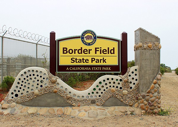
Border Field State Park monument
Border Field State Park and Tijuana River National Estuarine Research Preserve has the designation as a “wetland of International importance” by the International Ramsar Committee and is one of the 35 “Ramsar sites” in the U.S.A. The Tijuana River watershed starts in the Laguna Mountains where it originates at the confluence of Cottonwood Creek and Tecate Creek then flows into Mexico where the third major tributary of Rio Las Palmas system joins before the Tijuana River turns north and reenters the U.S. near San Ysidro.
Over time, the river created a 3-mile wide valley. A bay existed in the valley over 7000 years ago. The sea level was much lower and the shoreline was located 0.75 mile offshore. Sea levels slowly rose, and sediments were carried downstream by the river and deposited near its mouth. These sediments gradually blocked the river mouth and restricted tidal flushing, and over time created the estuary that is present today.
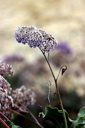
Sea lavender grows at the base of Monument Mesa
The hike along the beach and nearby dunes will surprise visitors with its beautiful views and diversity of animal and plant life. Once in the southwest corner of the continental United States, the trail system consists of the South Beach, North Beach, and Beach trails. The South Beach and North Beach trails follow the tide line along the coast and lead to the mouth of the Tijuana River, while the Beach Trail connects the beach to the park entrance road near the kiosk.
The South Beach trailhead is located on the beach at the west end of the road and turnaround below the north face of Monument Mesa, 200 yards north of the international border, and leads northward along the shoreline. The surface consists of soft beach sands. During spring and summer, hikers and others are restricted to walking along the wet portion of the sands to prevent disturbance to a least tern and snowy plover nesting area that has been set aside in the dune area east of the trail. These small shorebirds hunt small fish near the shore and nest in open areas on the beach. Many other shore birds are visible as the trail passes along the beach, including pelicans, willets, gulls, and plovers. Seals, sea lions, dolphins, and whales can occasionally be spotted offshore.
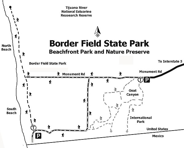
Border Field State Park trail map
At the intersection of South Beach and North Beach trails, approximately 0.6 mile north of the border, is the Beach Trail that serves as an access road for research sites in the area and leads to the gate entrance. It is near an abandoned concrete outfall remnant on the beach with the intersection marked with a wood and metal signpost. The Beach Trail is on a packed earth surface that leads east through the dune area and crosses a series of salt flats. Here the vegetation includes elderberry, bladderpod, crystalline ice plant, pickleweed, grasses, Shaw’s agave, and other coast sage scrub and other wetland plants.
The North Beach Trail continues along the shoreline for another 0.6 mile until it reaches the mouth of the Tijuana River. Bring binoculars to better witness the abundance of bird life, which includes migratory species on this Pacific flyway that extends from Alaska to the southern end of South America.
Border Field State Park
Distance from downtown San Diego: 18 miles. Allow 35 minutes driving time (Imperial Beach). From I-5 S, exit at Coronado Ave. and continue south through the intersection on Hollister Street for 2.2 miles until it ends at Monument Rd. Turn right (west) and proceed 1.3 miles on Monument Road to the Border Field State Park entrance gate. After entering the park, drive past the entrance kiosk and follow the paved road as it turns south for 0.5 mile and then west 0.4 mile. The road leads to the top of Monument Mesa, where parking is available at Friendship Park. Note that the entrance gate is frequently closed due to flooding, but the park remains open. There is an alternative lot near the south side of the entrance gate. Proceed to the trailhead on foot or take the Beach Trail that intersects with the entrance road. There is a vehicle fee charged past the gate.
Hiking Length: 1.5 miles, out-and-back.
Difficulty: Easy with elevation gain/loss less than 200 ft. Trails open to hikers, bicyclists, and equestrians, dogs (on leashes) restricted to picnic area. Hours open: 9:30 a.m.–6:30 or 7:00 p.m. Usage restricted to wet sand near shore from March 1 through September 30. Swimming not recommended due to possible water-quality issues, rip tides, strong currents, and no lifeguards. Facilities, barbeques, and horse corrals available.
Here's something you might be interested in.
No bay at Border Field State Park for about 7000 years
Explore a beach and estuary at the extreme southwest corner of the continental USA
No bay at Border Field State Park for about 7000 years
Explore a beach and estuary at the extreme southwest corner of the continental USA
The trail leading to the beach
Border Field State Park is where delegations from both the U.S. and Mexico began the survey of the border in 1850 after the Treaty of Guadalupe Hidalgo was concluded on February 2, 1848, officially ending the U.S./Mexican War. From 1929 until the early 1960s, the park was home to a military base that included a radar installation, shore battery, auxiliary landing field, and fire-control station. The flat area to the south was the site of an aerial gunnery target range, and a metal track was constructed to provide aircraft pilots with moving targets.
Border Field State Park monument
Border Field State Park and Tijuana River National Estuarine Research Preserve has the designation as a “wetland of International importance” by the International Ramsar Committee and is one of the 35 “Ramsar sites” in the U.S.A. The Tijuana River watershed starts in the Laguna Mountains where it originates at the confluence of Cottonwood Creek and Tecate Creek then flows into Mexico where the third major tributary of Rio Las Palmas system joins before the Tijuana River turns north and reenters the U.S. near San Ysidro.
Over time, the river created a 3-mile wide valley. A bay existed in the valley over 7000 years ago. The sea level was much lower and the shoreline was located 0.75 mile offshore. Sea levels slowly rose, and sediments were carried downstream by the river and deposited near its mouth. These sediments gradually blocked the river mouth and restricted tidal flushing, and over time created the estuary that is present today.
Sea lavender grows at the base of Monument Mesa
The hike along the beach and nearby dunes will surprise visitors with its beautiful views and diversity of animal and plant life. Once in the southwest corner of the continental United States, the trail system consists of the South Beach, North Beach, and Beach trails. The South Beach and North Beach trails follow the tide line along the coast and lead to the mouth of the Tijuana River, while the Beach Trail connects the beach to the park entrance road near the kiosk.
The South Beach trailhead is located on the beach at the west end of the road and turnaround below the north face of Monument Mesa, 200 yards north of the international border, and leads northward along the shoreline. The surface consists of soft beach sands. During spring and summer, hikers and others are restricted to walking along the wet portion of the sands to prevent disturbance to a least tern and snowy plover nesting area that has been set aside in the dune area east of the trail. These small shorebirds hunt small fish near the shore and nest in open areas on the beach. Many other shore birds are visible as the trail passes along the beach, including pelicans, willets, gulls, and plovers. Seals, sea lions, dolphins, and whales can occasionally be spotted offshore.
Border Field State Park trail map
At the intersection of South Beach and North Beach trails, approximately 0.6 mile north of the border, is the Beach Trail that serves as an access road for research sites in the area and leads to the gate entrance. It is near an abandoned concrete outfall remnant on the beach with the intersection marked with a wood and metal signpost. The Beach Trail is on a packed earth surface that leads east through the dune area and crosses a series of salt flats. Here the vegetation includes elderberry, bladderpod, crystalline ice plant, pickleweed, grasses, Shaw’s agave, and other coast sage scrub and other wetland plants.
The North Beach Trail continues along the shoreline for another 0.6 mile until it reaches the mouth of the Tijuana River. Bring binoculars to better witness the abundance of bird life, which includes migratory species on this Pacific flyway that extends from Alaska to the southern end of South America.
Border Field State Park
Distance from downtown San Diego: 18 miles. Allow 35 minutes driving time (Imperial Beach). From I-5 S, exit at Coronado Ave. and continue south through the intersection on Hollister Street for 2.2 miles until it ends at Monument Rd. Turn right (west) and proceed 1.3 miles on Monument Road to the Border Field State Park entrance gate. After entering the park, drive past the entrance kiosk and follow the paved road as it turns south for 0.5 mile and then west 0.4 mile. The road leads to the top of Monument Mesa, where parking is available at Friendship Park. Note that the entrance gate is frequently closed due to flooding, but the park remains open. There is an alternative lot near the south side of the entrance gate. Proceed to the trailhead on foot or take the Beach Trail that intersects with the entrance road. There is a vehicle fee charged past the gate.
Hiking Length: 1.5 miles, out-and-back.
Difficulty: Easy with elevation gain/loss less than 200 ft. Trails open to hikers, bicyclists, and equestrians, dogs (on leashes) restricted to picnic area. Hours open: 9:30 a.m.–6:30 or 7:00 p.m. Usage restricted to wet sand near shore from March 1 through September 30. Swimming not recommended due to possible water-quality issues, rip tides, strong currents, and no lifeguards. Facilities, barbeques, and horse corrals available.
Comments