Here's something you might be interested in.
Ask a Hipster — Advice you didn't know you needed
Big Screen — Movie commentary
Blurt — Music's inside track
Booze News — San Diego spirits
Classical Music — Immortal beauty
Classifieds — Free and easy
Cover Stories — Front-page features
Drinks All Around — Bartenders' drink recipes
Excerpts — Literary and spiritual excerpts
Feast! — Food & drink reviews
Feature Stories — Local news & stories
Fishing Report — What’s getting hooked from ship and shore
From the Archives — Spotlight on the past
Golden Dreams — Talk of the town
The Gonzo Report — Making the musical scene, or at least reporting from it
Letters — Our inbox
Movies@Home — Local movie buffs share favorites
Movie Reviews — Our critics' picks and pans
Musician Interviews — Up close with local artists
Neighborhood News from Stringers — Hyperlocal news
News Ticker — News & politics
Obermeyer — San Diego politics illustrated
Outdoors — Weekly changes in flora and fauna
Overheard in San Diego — Eavesdropping illustrated
Poetry — The old and the new
Reader Travel — Travel section built by travelers
Reading — The hunt for intellectuals
Roam-O-Rama — SoCal's best hiking/biking trails
San Diego Beer — Inside San Diego suds
SD on the QT — Almost factual news
Sheep and Goats — Places of worship
Special Issues — The best of
Street Style — San Diego streets have style
Surf Diego — Real stories from those braving the waves
Theater — On stage in San Diego this week
Tin Fork — Silver spoon alternative
Under the Radar — Matt Potter's undercover work
Unforgettable — Long-ago San Diego
Unreal Estate — San Diego's priciest pads
Your Week — Daily event picks
Not the highest peak but maybe the best view
A walk among the survivors of the Cedar Fire to Eagle Peak
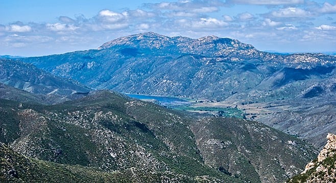
San Diego River Valley viewed from the top of the peak.
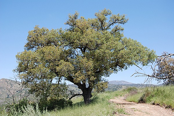
Engelmann oak on the Eagle Peak trail
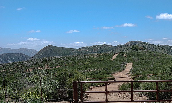
Eagle Peak trailhead
Eagle Peak is not the highest peak in the area but it has a commanding 360-degree view of the San Diego River canyon, the river’s main tributaries, and all of the surrounding peaks. It is a popular destination for local area rock climbers, but the trip described here does not require any special climbing skills. Much of the hike goes through grassy fields with scattered Engelmann oaks or relatively open chaparral. When the ceanothus is in bloom, the shrubs will be covered with a mist of blue blossoms and a wonderful fragrance can be experienced. Wildflowers are abundant here in the spring and include wine cup clarkia, the shy mariposa lily, caterpillar phacelia, wooly paintbrush, and many others.
The trail leads straight ahead from the trailhead, passing through chaparral dominated by chamise. Closer inspection will allow discovery of a scattering of manzanita, wild cucumber, virgin’s bower, and mountain blue curls among the gray-green chamise, some or all of which may be blooming depending on the season. The trail begins to rise and goes to the top of a hill and under a few Engelmann oaks set in non-native grassland. Engelmann oaks are not as fire resilient as coast live oaks, but these managed to survive the 2003 Cedar Fire that scorched this whole area.
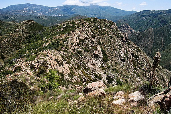
Looking east from Eagle Peak
From the top of the hill, the trail declines to a saddle, 0.66 mile from the trailhead where the trail to Boulder Creek’s Three Sisters Waterfall splits off and down to the south. The trail to Eagle Peak goes straight ahead (west) from this point and continues up the side of a south-facing slope vegetated with a mixture of foothill chaparral shrubs, including scrub oaks, ceanothus, and California sagebrush as well as chamise.
Beyond the Three Sisters Falls split the trail is less traveled and can be narrow in places so there is a chance of ticks hitching a ride. Light colored long pants and sleeves help! At 1.35 miles from the parking area, the trail crosses a saddle and begins a slow descent into a shallow valley, while staying on its north-facing slope. The aspect of this slope protects it somewhat from the sun’s direct rays, permitting the growth of a more lush coast live oak woodland with an understory of scrub oak, white-thorn and cup-leaf ceanothus, winter current, and manzanita. If hiking in late winter or spring, there will be an abundance of blooming wildflowers including the scarlet bugler, baby blue eyes, owl’s clover, and the fringed Indian pink.
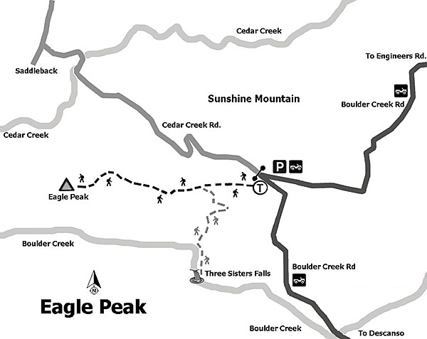
Map to Eagle Peak
There is a second fork in the trail 1.7 miles from the start. The trail to the left goes about 0.2 mile to a lookout with spectacular views of the rugged Boulder Creek and Eagle Peak cliffs. The trail straight ahead continues 0.4 mile with about 300 feet of elevation gain to the peak. The trail becomes increasingly difficult to follow from here, with several false peaks to surmount before actually reaching Eagle Peak itself and care needed due to the sharp drop off. However, the climb is worth it for the perspective it gives you on this whole area that includes views of San Diego to the west and Cuyamaca Peak to the east. Sign the hiker’s register before returning to your vehicle the way you came.
The shear portion of Eagle Peak is closed to rock climbers during raptor nesting season. A map is available.
Distance from downtown San Diego: 65 miles. Allow about 1.45 hours driving time (Cleveland National Forest). From I-8, exit north on SR-79 and then west on Riverside Dr. Turn west on Viejas Grade then make an immediate right past the store onto Oak Grove Dr. Turn right on Boulder Creek Rd. and drive 13 miles (7 miles is on a well-kept dirt road) to a hairpin turn that intersects Cedar Creek Rd. and the trailhead. The trailhead is for both Three Sisters Falls and Eagle Peak with Cedar Creek Fire road slightly to the north. Park near the hairpin turn with an USFS Adventure Pass in view. The Boulder Creek Rd. trailhead also can be accessed via Engineers Road from Lake Cuyamaca. It is a shorter route but has many hairpin turns.
Hiking length: 4.2 miles out-and-back.
Difficulty: Moderately strenuous. Elevation gain/loss 1,000 feet. Most of the hike is on an easily followed trail. However, the last 0.4 mile up to the peak is over more difficult terrain and requires some bushwhacking where navigation skills will come in handy. No facilities or water.
Here's something you might be interested in.
Not the highest peak but maybe the best view
A walk among the survivors of the Cedar Fire to Eagle Peak
Not the highest peak but maybe the best view
A walk among the survivors of the Cedar Fire to Eagle Peak
San Diego River Valley viewed from the top of the peak.
Engelmann oak on the Eagle Peak trail
Eagle Peak trailhead
Eagle Peak is not the highest peak in the area but it has a commanding 360-degree view of the San Diego River canyon, the river’s main tributaries, and all of the surrounding peaks. It is a popular destination for local area rock climbers, but the trip described here does not require any special climbing skills. Much of the hike goes through grassy fields with scattered Engelmann oaks or relatively open chaparral. When the ceanothus is in bloom, the shrubs will be covered with a mist of blue blossoms and a wonderful fragrance can be experienced. Wildflowers are abundant here in the spring and include wine cup clarkia, the shy mariposa lily, caterpillar phacelia, wooly paintbrush, and many others.
The trail leads straight ahead from the trailhead, passing through chaparral dominated by chamise. Closer inspection will allow discovery of a scattering of manzanita, wild cucumber, virgin’s bower, and mountain blue curls among the gray-green chamise, some or all of which may be blooming depending on the season. The trail begins to rise and goes to the top of a hill and under a few Engelmann oaks set in non-native grassland. Engelmann oaks are not as fire resilient as coast live oaks, but these managed to survive the 2003 Cedar Fire that scorched this whole area.
Looking east from Eagle Peak
From the top of the hill, the trail declines to a saddle, 0.66 mile from the trailhead where the trail to Boulder Creek’s Three Sisters Waterfall splits off and down to the south. The trail to Eagle Peak goes straight ahead (west) from this point and continues up the side of a south-facing slope vegetated with a mixture of foothill chaparral shrubs, including scrub oaks, ceanothus, and California sagebrush as well as chamise.
Beyond the Three Sisters Falls split the trail is less traveled and can be narrow in places so there is a chance of ticks hitching a ride. Light colored long pants and sleeves help! At 1.35 miles from the parking area, the trail crosses a saddle and begins a slow descent into a shallow valley, while staying on its north-facing slope. The aspect of this slope protects it somewhat from the sun’s direct rays, permitting the growth of a more lush coast live oak woodland with an understory of scrub oak, white-thorn and cup-leaf ceanothus, winter current, and manzanita. If hiking in late winter or spring, there will be an abundance of blooming wildflowers including the scarlet bugler, baby blue eyes, owl’s clover, and the fringed Indian pink.
Map to Eagle Peak
There is a second fork in the trail 1.7 miles from the start. The trail to the left goes about 0.2 mile to a lookout with spectacular views of the rugged Boulder Creek and Eagle Peak cliffs. The trail straight ahead continues 0.4 mile with about 300 feet of elevation gain to the peak. The trail becomes increasingly difficult to follow from here, with several false peaks to surmount before actually reaching Eagle Peak itself and care needed due to the sharp drop off. However, the climb is worth it for the perspective it gives you on this whole area that includes views of San Diego to the west and Cuyamaca Peak to the east. Sign the hiker’s register before returning to your vehicle the way you came.
The shear portion of Eagle Peak is closed to rock climbers during raptor nesting season. A map is available.
Distance from downtown San Diego: 65 miles. Allow about 1.45 hours driving time (Cleveland National Forest). From I-8, exit north on SR-79 and then west on Riverside Dr. Turn west on Viejas Grade then make an immediate right past the store onto Oak Grove Dr. Turn right on Boulder Creek Rd. and drive 13 miles (7 miles is on a well-kept dirt road) to a hairpin turn that intersects Cedar Creek Rd. and the trailhead. The trailhead is for both Three Sisters Falls and Eagle Peak with Cedar Creek Fire road slightly to the north. Park near the hairpin turn with an USFS Adventure Pass in view. The Boulder Creek Rd. trailhead also can be accessed via Engineers Road from Lake Cuyamaca. It is a shorter route but has many hairpin turns.
Hiking length: 4.2 miles out-and-back.
Difficulty: Moderately strenuous. Elevation gain/loss 1,000 feet. Most of the hike is on an easily followed trail. However, the last 0.4 mile up to the peak is over more difficult terrain and requires some bushwhacking where navigation skills will come in handy. No facilities or water.