Here's something you might be interested in.
Ask a Hipster — Advice you didn't know you needed
Big Screen — Movie commentary
Blurt — Music's inside track
Booze News — San Diego spirits
Classical Music — Immortal beauty
Classifieds — Free and easy
Cover Stories — Front-page features
Drinks All Around — Bartenders' drink recipes
Excerpts — Literary and spiritual excerpts
Feast! — Food & drink reviews
Feature Stories — Local news & stories
Fishing Report — What’s getting hooked from ship and shore
From the Archives — Spotlight on the past
Golden Dreams — Talk of the town
The Gonzo Report — Making the musical scene, or at least reporting from it
Letters — Our inbox
Movies@Home — Local movie buffs share favorites
Movie Reviews — Our critics' picks and pans
Musician Interviews — Up close with local artists
Neighborhood News from Stringers — Hyperlocal news
News Ticker — News & politics
Obermeyer — San Diego politics illustrated
Outdoors — Weekly changes in flora and fauna
Overheard in San Diego — Eavesdropping illustrated
Poetry — The old and the new
Reader Travel — Travel section built by travelers
Reading — The hunt for intellectuals
Roam-O-Rama — SoCal's best hiking/biking trails
San Diego Beer — Inside San Diego suds
SD on the QT — Almost factual news
Sheep and Goats — Places of worship
Special Issues — The best of
Street Style — San Diego streets have style
Surf Diego — Real stories from those braving the waves
Theater — On stage in San Diego this week
Tin Fork — Silver spoon alternative
Under the Radar — Matt Potter's undercover work
Unforgettable — Long-ago San Diego
Unreal Estate — San Diego's priciest pads
Your Week — Daily event picks
A lush riparian area despite a year of drought
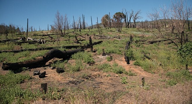
The controlled burn killed all or most of the lilacs and young black oaks, leaving a weedy wasteland.
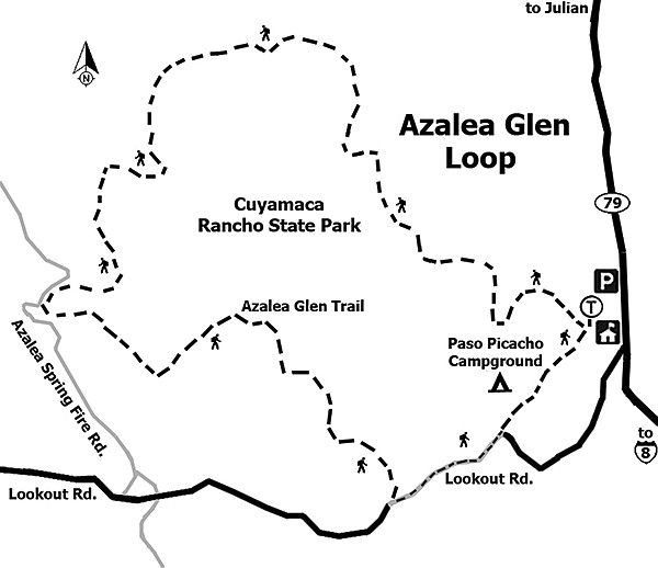
The Azalea Glen Loop Trail is on the slopes of Cuyamaca Mountain, the second-highest peak in San Diego County. Despite the fact that the area is still recovering from the 2003 Cedar Fire that devastated most of Cuyamaca Rancho State Park, there is a wealth of fascinating things here to see and experience.
From the trailhead, begin hiking through a mixed forest of Coulter pines, western red cedar, black oaks, white fir, Jeffrey pines, and interior live oaks, with a shrub understory including wild California rose, Palmer lilac, Eastwood manzanita, snowberry, white lilacs, and southern honeysuckle. Shortly after starting the hike, however, you will enter an area that was subject to an ill-conceived controlled burn in 2011 meant to create a more favorable habitat for conifers. With the exceptions of scattered forested patches, including the campground and Azalea Creek, the 2003 Cedar Fire left few trees unburnt. While the black oaks, lilacs, and other plants had made an amazing recovery, the controlled burn killed all or most of the lilacs and young black oaks, leaving a weedy wasteland in an attempt to tip the balance in favor of pines.
Fortunately, you soon leave the controlled burn area and find an abundance of newly remerging life. There are several trails branching off in other directions, but always with an instructive sign; just note the directions on the sign and continue on the Azalea Glen Loop Trail. At about 0.7 mile from the trailhead, the Azalea Glen Loop Trail merges with a California Riding and Hiking Trail as it approaches Azalea Creek. This is perhaps the most delightful part of the trail, as it enters the lush riparian vegetation bordering a flowing stream, even in this drought year, with dogwoods, western azaleas, willows, rushes, and horsetails lining the banks of the stream and shaded beneath towering western red cedars, white firs, Fremont cottonwoods, and black oaks.
Further ahead, the trail leaves the creek and rises more rapidly as it passes through tall, dense growths of white-flowered (in season) Palmer lilacs. The Azalea Spring Fire Road is 1.7 miles from the trailhead, with the Azalea Spring just beyond. At this point are interesting views off to the east of mountains in the desert as well as of the nearer Lake Cuyamaca and Stonewall Peak. Go left, down the fire road, perhaps 0.2 mile, and watch for the continuation of the Azalea Glen Trail branching off to the left. Take it back to your vehicle at the campground.
Distance from downtown San Diego: 51 miles. Allow 1 hour (Cuyamaca Rancho State Park). From CA-163N merge onto I-8E and drive 38 miles to its junction with SR-79 near Descanso. Exit I-8E and go north on SR-79 for 11.8 miles to left turn into the Paso Picacho Campground. The current day-use fee is $8, payable at the entrance, or put the fee in an envelope and slip it into the box provided if the entry kiosk is not staffed. Park in the day-use area and find the Azalea Glen trailhead, visible just southwest of the parking lot. Hiking length: A 3-mile loop trail. Difficulty: Easy, with about 500 feet of elevation gain. The trail is well-maintained, signed, and easy to follow. This is a good hike for children, as there are few hazards and much to keep them interested. There was a concern about mountain lions back in the 1990s, but there have been no recent reports. Dogs are not permitted on Cuyamaca trails. Facilities are in the campground near the day-use parking lot.
Distance from downtown San Diego: 51 miles. Allow 1 hour (Cuyamaca Rancho State Park). From CA-163N merge onto I-8E and drive 38 miles to its junction with SR-79 near Descanso. Exit I-8E and go north on SR-79 for 11.8 miles to left turn into the Paso Picacho Campground.
The current day-use fee is $8, payable at the entrance, or put the fee in an envelope and slip it into the box provided if the entry kiosk is not staffed. Park in the day-use area and find the Azalea Glen trailhead, visible just southwest of the parking lot.
Hiking length: A 3-mile loop trail.
Difficulty: Easy, with about 500 feet of elevation gain. The trail is well-maintained, signed, and easy to follow. This is a good hike for children, as there are few hazards and much to keep them interested. There was a concern about mountain lions back in the 1990s, but there have been no recent reports.
Dogs are not permitted on Cuyamaca trails. Facilities are in the campground near the day-use parking lot.
Here's something you might be interested in.
A lush riparian area despite a year of drought
A lush riparian area despite a year of drought
The controlled burn killed all or most of the lilacs and young black oaks, leaving a weedy wasteland.
The Azalea Glen Loop Trail is on the slopes of Cuyamaca Mountain, the second-highest peak in San Diego County. Despite the fact that the area is still recovering from the 2003 Cedar Fire that devastated most of Cuyamaca Rancho State Park, there is a wealth of fascinating things here to see and experience.
From the trailhead, begin hiking through a mixed forest of Coulter pines, western red cedar, black oaks, white fir, Jeffrey pines, and interior live oaks, with a shrub understory including wild California rose, Palmer lilac, Eastwood manzanita, snowberry, white lilacs, and southern honeysuckle. Shortly after starting the hike, however, you will enter an area that was subject to an ill-conceived controlled burn in 2011 meant to create a more favorable habitat for conifers. With the exceptions of scattered forested patches, including the campground and Azalea Creek, the 2003 Cedar Fire left few trees unburnt. While the black oaks, lilacs, and other plants had made an amazing recovery, the controlled burn killed all or most of the lilacs and young black oaks, leaving a weedy wasteland in an attempt to tip the balance in favor of pines.
Fortunately, you soon leave the controlled burn area and find an abundance of newly remerging life. There are several trails branching off in other directions, but always with an instructive sign; just note the directions on the sign and continue on the Azalea Glen Loop Trail. At about 0.7 mile from the trailhead, the Azalea Glen Loop Trail merges with a California Riding and Hiking Trail as it approaches Azalea Creek. This is perhaps the most delightful part of the trail, as it enters the lush riparian vegetation bordering a flowing stream, even in this drought year, with dogwoods, western azaleas, willows, rushes, and horsetails lining the banks of the stream and shaded beneath towering western red cedars, white firs, Fremont cottonwoods, and black oaks.
Further ahead, the trail leaves the creek and rises more rapidly as it passes through tall, dense growths of white-flowered (in season) Palmer lilacs. The Azalea Spring Fire Road is 1.7 miles from the trailhead, with the Azalea Spring just beyond. At this point are interesting views off to the east of mountains in the desert as well as of the nearer Lake Cuyamaca and Stonewall Peak. Go left, down the fire road, perhaps 0.2 mile, and watch for the continuation of the Azalea Glen Trail branching off to the left. Take it back to your vehicle at the campground.
Distance from downtown San Diego: 51 miles. Allow 1 hour (Cuyamaca Rancho State Park). From CA-163N merge onto I-8E and drive 38 miles to its junction with SR-79 near Descanso. Exit I-8E and go north on SR-79 for 11.8 miles to left turn into the Paso Picacho Campground. The current day-use fee is $8, payable at the entrance, or put the fee in an envelope and slip it into the box provided if the entry kiosk is not staffed. Park in the day-use area and find the Azalea Glen trailhead, visible just southwest of the parking lot. Hiking length: A 3-mile loop trail. Difficulty: Easy, with about 500 feet of elevation gain. The trail is well-maintained, signed, and easy to follow. This is a good hike for children, as there are few hazards and much to keep them interested. There was a concern about mountain lions back in the 1990s, but there have been no recent reports. Dogs are not permitted on Cuyamaca trails. Facilities are in the campground near the day-use parking lot.
Distance from downtown San Diego: 51 miles. Allow 1 hour (Cuyamaca Rancho State Park). From CA-163N merge onto I-8E and drive 38 miles to its junction with SR-79 near Descanso. Exit I-8E and go north on SR-79 for 11.8 miles to left turn into the Paso Picacho Campground.
The current day-use fee is $8, payable at the entrance, or put the fee in an envelope and slip it into the box provided if the entry kiosk is not staffed. Park in the day-use area and find the Azalea Glen trailhead, visible just southwest of the parking lot.
Hiking length: A 3-mile loop trail.
Difficulty: Easy, with about 500 feet of elevation gain. The trail is well-maintained, signed, and easy to follow. This is a good hike for children, as there are few hazards and much to keep them interested. There was a concern about mountain lions back in the 1990s, but there have been no recent reports.
Dogs are not permitted on Cuyamaca trails. Facilities are in the campground near the day-use parking lot.
Comments