Sponsored
Sponsored
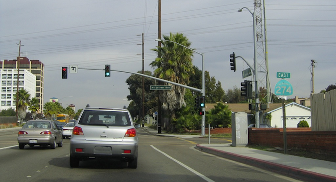
Motorists traveling northbound on 805 out of Mission Valley into Kearny Mesa may have recently noticed something covered up on the green freeway signs indicating the Balboa Avenue exit. Covered over in mismatched green is the highway symbol for State Route 274.
SR-274 was deactivated in 1999, says Caltrans spokesperson Hayden Manning. The road was given to San Diego in May of 2001, but the signs weren’t changed due to the expense, until now.
Originally commissioned in 1971, SR-274 was deactivated because it is within the city limits of San Diego: it runs the entire route of Balboa Avenue, from its western terminus of Mission Bay Drive, east to I-15. The city is now responsible for the road’s maintenance, not Caltrans.
Since 1933, Rosecrans Street and Cañon Street, up to Ft. Rosecrans National Cemetery and Cabrillo National Monument, used to be State Route 209. Its state route number was dropped a few years ago. The I-5 exit signs indicating SR-209 were replaced within the past few years.
Manning points out that several regional roads still maintain their state route number, even though parts of them are in cities. An example is State Route 75 — the Coronado Bridge, across to Orange Avenue in Coronado and down the Silver Strand into Imperial Beach and back to I-5. The section within the City of Coronado is that city’s responsibility, as it is on Hwy. 75 in the cities of Imperial Beach and San Diego.
However, many computer and smartphone mapping programs still list the deleted numbered state routes and use the signage of the once state highway — the green, California “miner’s spade” sign design.
Recently, a friend’s smartphone app. advised him the best way to Kearny Mesa from coastal North County was to take I-5 south to SR-274 (now Balboa Avenue) east, rather than the 805 south — which would have saved him about a half an hour in travel time.