Here's something you might be interested in.
Ask a Hipster — Advice you didn't know you needed
Big Screen — Movie commentary
Blurt — Music's inside track
Booze News — San Diego spirits
Classical Music — Immortal beauty
Classifieds — Free and easy
Cover Stories — Front-page features
Drinks All Around — Bartenders' drink recipes
Excerpts — Literary and spiritual excerpts
Feast! — Food & drink reviews
Feature Stories — Local news & stories
Fishing Report — What’s getting hooked from ship and shore
From the Archives — Spotlight on the past
Golden Dreams — Talk of the town
The Gonzo Report — Making the musical scene, or at least reporting from it
Letters — Our inbox
Movies@Home — Local movie buffs share favorites
Movie Reviews — Our critics' picks and pans
Musician Interviews — Up close with local artists
Neighborhood News from Stringers — Hyperlocal news
News Ticker — News & politics
Obermeyer — San Diego politics illustrated
Outdoors — Weekly changes in flora and fauna
Overheard in San Diego — Eavesdropping illustrated
Poetry — The old and the new
Reader Travel — Travel section built by travelers
Reading — The hunt for intellectuals
Roam-O-Rama — SoCal's best hiking/biking trails
San Diego Beer — Inside San Diego suds
SD on the QT — Almost factual news
Sheep and Goats — Places of worship
Special Issues — The best of
Street Style — San Diego streets have style
Surf Diego — Real stories from those braving the waves
Theater — On stage in San Diego this week
Tin Fork — Silver spoon alternative
Under the Radar — Matt Potter's undercover work
Unforgettable — Long-ago San Diego
Unreal Estate — San Diego's priciest pads
Your Week — Daily event picks
Scenic road through recovery
The oaks still stand, but Margaret’s cabin burned down.
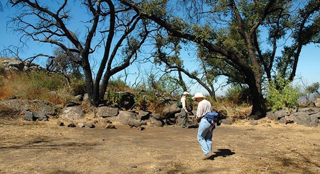
Hikers at the former site of Margaret Minshall’s cabin, which burned down in the 2003 Cedar Fire.
The 397 acres of chaparral and oak woodlands that are included in this open-space preserve were gifted to the county by the Margaret Minshall family in the 1980s. Minshall was a Hoover High School physical education teacher who built a cabin on her property in 1936 and later, during the 1940s, operated a summer camp there for girls. Almost 95 percent of the preserve was consumed in the 2003 Cedar Fire, including the original Minshall cabin. Today, the preserve is recovering with young chaparral vegetation. Oakoasis has boulder-studded hillsides, acres of woods, multi-use trails, and sweeping views of the surrounding area and San Vicente Reservoir.
Part of the preserve’s trail system is included in the 110-mile Trans-County Trail (TCT) that is being developed between Torrey Pines State Preserve and Anza-Borrego Desert State Park. Over 70 percent of the TCT will utilize existing trails found within parks and preserves in the county. The Oakoasis parking area will be one of the staging areas for this trail when it officially opens some years from now.
The double trail starts from the parking lot and is a large clockwise loop followed by a smaller counter-clockwise loop. Begin the hike by descending on the TCT trail toward the west. Take signs marked “trail” and not TCT, as the loop will depart from the TCT, which will continue to the west. The trail marked TCT will be the return trail.
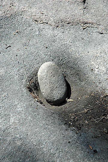
Take all rights at trail junctions until arriving at a “T” in the trail at a dirt road near the bottom of an oak-lined ravine, taking note of this rich riparian area that is recovering nicely since the fire. Turn left, and go through the shady oak grove, passing what is left of the Minshall cabin at 0.7 mile from the trailhead. After passing the cabin ruins, there will be a sign for the Upper Meadow Trail to the right. Go to the right/north following the Upper Meadow Trail signs where the first site of San Vicente Reservoir will be visible to the west. Take a short side trail to the west to the scenic overlook where there are good views of San Vicente Reservoir some 800 feet below. Return to the main trail and turn left for the steepest part of this hike up and over a 1480-foot saddle. Note how different the habitat is here from the riparian woodland below. Look for chamise, ceanothus or wild lilac, broom baccharis, white sage, scrub oak, flat-top buckwheat, laurel sumac, and red-barked manzanita in this chaparral habitat.
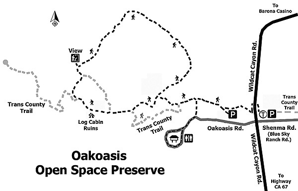
Pass an upper grassy meadow where there is a sign stating “half way” and continue circling right until descending again to the oak oasis ravine. There is the option of retracing steps from here to the trailhead, saving about a half-mile on the hike, but if doing this, some of the more scenic areas of the preserve will be missed. To continue, go through the oak oasis again about 300 yards until seeing a trail to the left marked TCT and follow it as it loops counter-clockwise around the wooded area. Note the riparian vegetation that includes coast live oak, toyon, basket bush, monkey flower, horehound, and watch out for the poison oak. At the junction with the main trail, turn right and retrace your steps back to the trailhead.
- Distance from downtown San Diego: About 27 miles. Allow 36 minutes (Lakeside). Get on CA-163N and merge onto I-8E. Take SR-67N and drive 5.8 miles to Mapleview St., where the freeway ends, and turn right/east. After 0.3 mile, turn left/north onto Ashwood St., which becomes Wildcat Canyon Rd. after 1 mile. The entrance to Oakoasis Preserve is 4.3 miles from the Ashwood/Mapleview intersection. Turn left/west into the entrance, immediately opposite Blue Sky Ranch Road. Go 0.1 mile on the paved road to the parking area.
- Hiking length: 3.4 miles round-trip. Allow 2.5 hours.
- Difficulty: Moderate with an elevation gain/loss of 700 feet. Steep in some areas for short distances. Trails are well-marked. Horses and dogs on leashes allowed. Hours are 7 a.m. to sunset daily. Facilities and a ranger station. Phone: 619-561-0580.
Here's something you might be interested in.
Scenic road through recovery
The oaks still stand, but Margaret’s cabin burned down.
Scenic road through recovery
The oaks still stand, but Margaret’s cabin burned down.
Hikers at the former site of Margaret Minshall’s cabin, which burned down in the 2003 Cedar Fire.
The 397 acres of chaparral and oak woodlands that are included in this open-space preserve were gifted to the county by the Margaret Minshall family in the 1980s. Minshall was a Hoover High School physical education teacher who built a cabin on her property in 1936 and later, during the 1940s, operated a summer camp there for girls. Almost 95 percent of the preserve was consumed in the 2003 Cedar Fire, including the original Minshall cabin. Today, the preserve is recovering with young chaparral vegetation. Oakoasis has boulder-studded hillsides, acres of woods, multi-use trails, and sweeping views of the surrounding area and San Vicente Reservoir.
Part of the preserve’s trail system is included in the 110-mile Trans-County Trail (TCT) that is being developed between Torrey Pines State Preserve and Anza-Borrego Desert State Park. Over 70 percent of the TCT will utilize existing trails found within parks and preserves in the county. The Oakoasis parking area will be one of the staging areas for this trail when it officially opens some years from now.
The double trail starts from the parking lot and is a large clockwise loop followed by a smaller counter-clockwise loop. Begin the hike by descending on the TCT trail toward the west. Take signs marked “trail” and not TCT, as the loop will depart from the TCT, which will continue to the west. The trail marked TCT will be the return trail.
Take all rights at trail junctions until arriving at a “T” in the trail at a dirt road near the bottom of an oak-lined ravine, taking note of this rich riparian area that is recovering nicely since the fire. Turn left, and go through the shady oak grove, passing what is left of the Minshall cabin at 0.7 mile from the trailhead. After passing the cabin ruins, there will be a sign for the Upper Meadow Trail to the right. Go to the right/north following the Upper Meadow Trail signs where the first site of San Vicente Reservoir will be visible to the west. Take a short side trail to the west to the scenic overlook where there are good views of San Vicente Reservoir some 800 feet below. Return to the main trail and turn left for the steepest part of this hike up and over a 1480-foot saddle. Note how different the habitat is here from the riparian woodland below. Look for chamise, ceanothus or wild lilac, broom baccharis, white sage, scrub oak, flat-top buckwheat, laurel sumac, and red-barked manzanita in this chaparral habitat.
Pass an upper grassy meadow where there is a sign stating “half way” and continue circling right until descending again to the oak oasis ravine. There is the option of retracing steps from here to the trailhead, saving about a half-mile on the hike, but if doing this, some of the more scenic areas of the preserve will be missed. To continue, go through the oak oasis again about 300 yards until seeing a trail to the left marked TCT and follow it as it loops counter-clockwise around the wooded area. Note the riparian vegetation that includes coast live oak, toyon, basket bush, monkey flower, horehound, and watch out for the poison oak. At the junction with the main trail, turn right and retrace your steps back to the trailhead.
- Distance from downtown San Diego: About 27 miles. Allow 36 minutes (Lakeside). Get on CA-163N and merge onto I-8E. Take SR-67N and drive 5.8 miles to Mapleview St., where the freeway ends, and turn right/east. After 0.3 mile, turn left/north onto Ashwood St., which becomes Wildcat Canyon Rd. after 1 mile. The entrance to Oakoasis Preserve is 4.3 miles from the Ashwood/Mapleview intersection. Turn left/west into the entrance, immediately opposite Blue Sky Ranch Road. Go 0.1 mile on the paved road to the parking area.
- Hiking length: 3.4 miles round-trip. Allow 2.5 hours.
- Difficulty: Moderate with an elevation gain/loss of 700 feet. Steep in some areas for short distances. Trails are well-marked. Horses and dogs on leashes allowed. Hours are 7 a.m. to sunset daily. Facilities and a ranger station. Phone: 619-561-0580.