Here's something you might be interested in.
Ask a Hipster — Advice you didn't know you needed
Big Screen — Movie commentary
Blurt — Music's inside track
Booze News — San Diego spirits
Classical Music — Immortal beauty
Classifieds — Free and easy
Cover Stories — Front-page features
Drinks All Around — Bartenders' drink recipes
Excerpts — Literary and spiritual excerpts
Feast! — Food & drink reviews
Feature Stories — Local news & stories
Fishing Report — What’s getting hooked from ship and shore
From the Archives — Spotlight on the past
Golden Dreams — Talk of the town
The Gonzo Report — Making the musical scene, or at least reporting from it
Letters — Our inbox
Movies@Home — Local movie buffs share favorites
Movie Reviews — Our critics' picks and pans
Musician Interviews — Up close with local artists
Neighborhood News from Stringers — Hyperlocal news
News Ticker — News & politics
Obermeyer — San Diego politics illustrated
Outdoors — Weekly changes in flora and fauna
Overheard in San Diego — Eavesdropping illustrated
Poetry — The old and the new
Reader Travel — Travel section built by travelers
Reading — The hunt for intellectuals
Roam-O-Rama — SoCal's best hiking/biking trails
San Diego Beer — Inside San Diego suds
SD on the QT — Almost factual news
Sheep and Goats — Places of worship
Special Issues — The best of
Street Style — San Diego streets have style
Surf Diego — Real stories from those braving the waves
Theater — On stage in San Diego this week
Tin Fork — Silver spoon alternative
Under the Radar — Matt Potter's undercover work
Unforgettable — Long-ago San Diego
Unreal Estate — San Diego's priciest pads
Your Week — Daily event picks
Hiking the Lower 48's Highest: Mt. Whitney, California
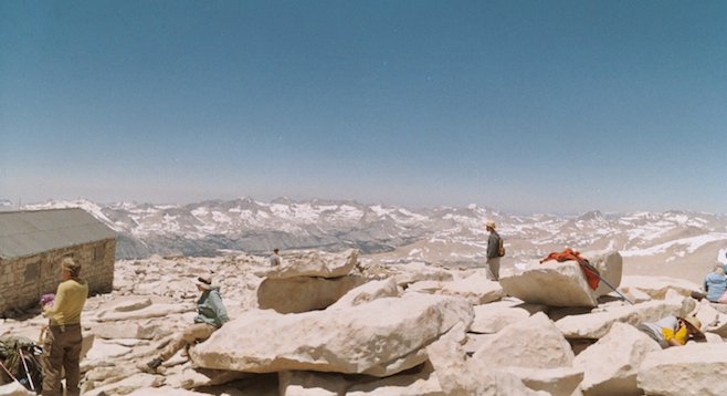
The summit of Mt. Whitney - finally
On a lonely stretch of Highway 395 in Central Cali, the Sierras rise from the earth and reach for the heavens.
It is here, and more specifically Mt. Whitney, where the modern-day hiker goes for a rite of passage. The test is a round-trip trek that traverses over 22 miles with an elevation gain of over 6,100 feet. The reward is the 14,496-foot summit, where you step foot on the highest point of the contiguous lower 48.
Towering like an impenetrable fortress above the small town of Lone Pine, the jagged gray edges of the mountain’s east face look daunting to those below. The town straddles Route 395 and pays homage to the region. Streets and businesses abound with the words “Sierra” or “Whitney” worked somehow into their name.
Due to the number of climbers attempting the climb each year, the National Park Service has developed a quota system. Today, no more than 160 climbers can be on the route on any given day. An April lottery is held each year with the number of spots and days drawn for by the local rangers.
Unfortunately, like all lotteries, there are few winners. However, the park service does post a calendar and updates it regularly as permits are returned or cancelled. So it’s possible to obtain a permit even if you aren’t originally awarded one.
Most parties break the climb up into two or three days. Our group chose to do it in one. We arrived at the Whitney Portal trailhead around 4:00 a.m., our headlights illuminating a black bear emerging from the brush. He retreated when he saw our car, but did not seem scared nor in any hurry to scamper away. It was the second bear we'd seen in two days. The first went lumbering through our campground.
Warning signs and bear-proof storage bins are everywhere. Remember, if there is food nearby, there are bears nearby!
Vehicle parking is literally feet from the start of the trail. Although there are no tent sites, many sleep in their car, or next to it. A restroom is also located at the trailhead – the last one you will see until you return. As all trash, including human waste, is required to be packed out, I would highly recommend you use it.
With our headlamps ablaze, we took off into the early morning darkness, putting in over an hour before dawn broke. As night turned to day, the dull colorless granite was transformed into deep hues of red and bronze. Our backs warmed by the sun, jackets and hats were quickly shed.
The trail begins at an elevation of over 8,000 feet and is constantly moving higher, though the incline is not too severe. A steady pace is easy enough to maintain, and before you know it you’ve arrived at the first set of lakes and the Outpost Campground sitting at 10,300 feet. With filtration equipment the water here is safe to drink.
Hike a couple more miles and you arrive at the last water and campsite. At the 12,000-foot Trail Camp, the water is cleaner, the temperature cooler and the air thinner.
We rested, and looked above. The next 2500 feet is the crux of the climb. The trail serpentines upwards, switching back and forth 99 times before the saddle is reached at the junction of the John Muir Trail.
Here, in a cruel twist, you lose altitude as the trail drops lower. Although the downward stretch is welcome from the previous steady uphill march, you know that the elevation must be regained and a physical price will have to be paid later.
After the rather exposed trail meanders around the back side of the mountain, it begins to move back upward. It is apparent the summit is close, but it’s not yet visible until you are within about 300 yards.
When the summit hut comes into view, it’s like a shot of adrenaline. You realize you have conquered your goal – and within minutes of the sighting you’re on top of the mountain at last!
Here's something you might be interested in.
Hiking the Lower 48's Highest: Mt. Whitney, California
Hiking the Lower 48's Highest: Mt. Whitney, California
The summit of Mt. Whitney - finally
On a lonely stretch of Highway 395 in Central Cali, the Sierras rise from the earth and reach for the heavens.
It is here, and more specifically Mt. Whitney, where the modern-day hiker goes for a rite of passage. The test is a round-trip trek that traverses over 22 miles with an elevation gain of over 6,100 feet. The reward is the 14,496-foot summit, where you step foot on the highest point of the contiguous lower 48.
Towering like an impenetrable fortress above the small town of Lone Pine, the jagged gray edges of the mountain’s east face look daunting to those below. The town straddles Route 395 and pays homage to the region. Streets and businesses abound with the words “Sierra” or “Whitney” worked somehow into their name.
Due to the number of climbers attempting the climb each year, the National Park Service has developed a quota system. Today, no more than 160 climbers can be on the route on any given day. An April lottery is held each year with the number of spots and days drawn for by the local rangers.
Unfortunately, like all lotteries, there are few winners. However, the park service does post a calendar and updates it regularly as permits are returned or cancelled. So it’s possible to obtain a permit even if you aren’t originally awarded one.
Most parties break the climb up into two or three days. Our group chose to do it in one. We arrived at the Whitney Portal trailhead around 4:00 a.m., our headlights illuminating a black bear emerging from the brush. He retreated when he saw our car, but did not seem scared nor in any hurry to scamper away. It was the second bear we'd seen in two days. The first went lumbering through our campground.
Warning signs and bear-proof storage bins are everywhere. Remember, if there is food nearby, there are bears nearby!
Vehicle parking is literally feet from the start of the trail. Although there are no tent sites, many sleep in their car, or next to it. A restroom is also located at the trailhead – the last one you will see until you return. As all trash, including human waste, is required to be packed out, I would highly recommend you use it.
With our headlamps ablaze, we took off into the early morning darkness, putting in over an hour before dawn broke. As night turned to day, the dull colorless granite was transformed into deep hues of red and bronze. Our backs warmed by the sun, jackets and hats were quickly shed.
The trail begins at an elevation of over 8,000 feet and is constantly moving higher, though the incline is not too severe. A steady pace is easy enough to maintain, and before you know it you’ve arrived at the first set of lakes and the Outpost Campground sitting at 10,300 feet. With filtration equipment the water here is safe to drink.
Hike a couple more miles and you arrive at the last water and campsite. At the 12,000-foot Trail Camp, the water is cleaner, the temperature cooler and the air thinner.
We rested, and looked above. The next 2500 feet is the crux of the climb. The trail serpentines upwards, switching back and forth 99 times before the saddle is reached at the junction of the John Muir Trail.
Here, in a cruel twist, you lose altitude as the trail drops lower. Although the downward stretch is welcome from the previous steady uphill march, you know that the elevation must be regained and a physical price will have to be paid later.
After the rather exposed trail meanders around the back side of the mountain, it begins to move back upward. It is apparent the summit is close, but it’s not yet visible until you are within about 300 yards.
When the summit hut comes into view, it’s like a shot of adrenaline. You realize you have conquered your goal – and within minutes of the sighting you’re on top of the mountain at last!
Comments