Sponsored
Sponsored
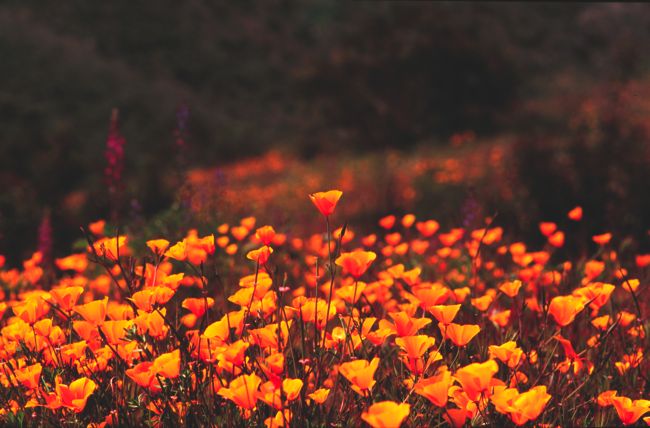
Your impression of Lake Jennings may be strongly colored by the season in which you choose to visit it — a not-unusual circumstance in many of San Diego County’s inland, low-elevation locales. Summer’s heat and drought bleaches all vibrant color out of the vegetation, so that by July through the first rainstorms late in the year the only color you see besides beige and brown is the blue of the sky and of the lake itself. In most years, though, February through April brings an almost unbelievable wave of green to the hillsides overlooking the lake. Not only that; in wetter years the profusion of wildflowers can be astounding.
Lake Jennings stores mostly imported water that when filtered becomes drinking water for more than a quarter million people in the East County region. It also serves as a recreational magnet for local residents — fishing, boating, and camping are popular; hiking and bicycling less so.
To get there, exit Interstate 8 at Lake Jennings Park Road, just east of El Cajon. Go north for about 0.3 mile and turn right on Harritt Road, following the signs to Lake Jennings. Once past the entrance, stay right, pay the small day-use fee at the bait shop, and continue driving on the winding, paved Bass Drive along the lake’s south and east shorelines. After nearly two miles you reach a parking lot where the paved road ends and a hikers’ unpaved trail continues.
From the starting point, the nearly level trail continues wrapping around the shoreline of the lake. The vegetation on the slopes is primarily of the coastal sage-scrub variety, which goes almost completely dormant in drought. The plants pack their growth and reproductive phases into the space of a few weeks or months, depending on how much rain falls. By March, wildflowers such as paintbrush, wild hyacinth, monkeyflower, lupine, and owl’s clover splash the hillsides with color highlights of every hue.
Continue for just 0.8 mile to a point on the trail overlooking the lake’s “Half Moon Cove.” Notice the broad saddle in the ridge to your right. Leave the trail at that point and climb up about 50 yards to that saddle, where a gorgeous vista opens to the northeast. You look down upon the table-flat floodplain of the San Diego River, and in the distance spot rock-ribbed El Cajon Mountain, whose sheer south face is known as “El Capitan” in these parts due to its resemblance to El Capitan in Yosemite National Park.
You can either retrace your steps, making this hike a mere 1.6-mile, round-trip stroll, or you can continue on toward Lake Jennings’ rustic campground on the north shore, where paved Bass Drive resumes. Another option would be to circle the lake using Bass Road, 4.6 miles for the entire loop. That option, of course, involves sharing the road with typically slow-moving automobiles.
Lake Jennings
As green as it gets at East County’s Lake Jennings
Distance from downtown San Diego: 20 miles
Hiking length: 1.6 miles (or more)
Difficulty: Easy