Here's something you might be interested in.
Ask a Hipster — Advice you didn't know you needed
Big Screen — Movie commentary
Blurt — Music's inside track
Booze News — San Diego spirits
Classical Music — Immortal beauty
Classifieds — Free and easy
Cover Stories — Front-page features
Drinks All Around — Bartenders' drink recipes
Excerpts — Literary and spiritual excerpts
Feast! — Food & drink reviews
Feature Stories — Local news & stories
Fishing Report — What’s getting hooked from ship and shore
From the Archives — Spotlight on the past
Golden Dreams — Talk of the town
The Gonzo Report — Making the musical scene, or at least reporting from it
Letters — Our inbox
Movies@Home — Local movie buffs share favorites
Movie Reviews — Our critics' picks and pans
Musician Interviews — Up close with local artists
Neighborhood News from Stringers — Hyperlocal news
News Ticker — News & politics
Obermeyer — San Diego politics illustrated
Outdoors — Weekly changes in flora and fauna
Overheard in San Diego — Eavesdropping illustrated
Poetry — The old and the new
Reader Travel — Travel section built by travelers
Reading — The hunt for intellectuals
Roam-O-Rama — SoCal's best hiking/biking trails
San Diego Beer — Inside San Diego suds
SD on the QT — Almost factual news
Sheep and Goats — Places of worship
Special Issues — The best of
Street Style — San Diego streets have style
Surf Diego — Real stories from those braving the waves
Theater — On stage in San Diego this week
Tin Fork — Silver spoon alternative
Under the Radar — Matt Potter's undercover work
Unforgettable — Long-ago San Diego
Unreal Estate — San Diego's priciest pads
Your Week — Daily event picks
Upper Aliso Canyon in Chino Hills State Park
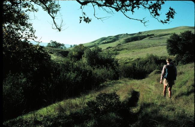
Upper Aliso Canyon vista
The sprawling Chino Hills State Park east of Los Angeles offers 14,000 acres of open space for hikers, equestrians, and mountain bikers to roam (note: dogs are not welcome). Unfortunately, the November 2008 “Freeway Complex Fire” swept some 95 percent of the state park’s lands. The landscape, however, is accustomed to periodic wildfires, and with this season’s past rainfall, it now looks as spring-green as ever. If you go, don’t wait past April, when green fades quickly to golden brown, and hiking shoes and socks tend to collect an awful lot of very sharp “stickers” (grass seeds).
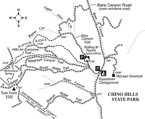
To get to the trailhead for the pleasant Upper Aliso Canyon Trail you’ll want to head to the east (San Bernardino County as opposed to Orange County) side of the park. From Corona (on Interstate 15), exit on the westbound 91 Freeway. Drive five miles, and then swing right on Highway 71. Continue another seven miles and exit at Soquel Canyon Parkway in Chino. Drive west on Soquel Canyon Parkway 1.0 mile to Elinvar Drive. Turn left, left again after 0.2 mile, and then immediately right on the gravel road entering Chino Hills State Park. Continue nearly three miles to the Rolling M Ranch (park office) at the end of the road, where parking is available.
On the loop through the upper reaches of Aliso and Raptor canyons, you’ll appreciate the fine vistas (on clear days, at least) of miles of empty hill country presided over by the snow-dusted summits of the San Gabriel Mountains. Depending on the mix of recent rainfall and warm sunshine, you may encounter a jungle-like growth of nonnative mustard plants growing alongside (or even on) the upper parts of the trail. If that’s the case and you don’t feel like fighting it, just make this hike an out-and-back one.
Starting from Rolling M Ranch, head north past outlying staff residences and continue on an old dirt road up the west bank of sycamore-lined Aliso Canyon. At 0.7 mile, the old road passes under some high-voltage wires and soon bends decidedly west up along the bottom of a shallow tributary called Raptor Canyon.
At 1.1 miles, the road veers right and zigzags up the slope to the north. Stay left on the path that strikes west up a grassy ridge just south of Raptor Canyon. After crossing under another powerline, you begin a stiff climb of about 500 vertical feet, up through tall-growing grasses, topping out on Raptor Ridge. On the way up, you can look out over the upper reaches of Raptor Canyon, which features some rather scraggly looking live oak and walnut trees, victims and survivors of the fire. True to the namesake of this canyon, you’ll probably notice a hawk or two cruising on updrafts.
At 2.0 miles, atop Raptor Ridge, the trail descends a little and you meet a powerline access road. Turn left (east), walk 0.3 mile toward a complex of electric towers, and then go right on a road that drops into the wooded drainage to the south. At the bottom (2.8 miles), turn east and return toward your starting point by way of the gently descending Telegraph Canyon Trail (a graded dirt road). When you reach the paved entrance road, turn left and complete the remaining 200 yards back to Rolling M Ranch.
This article contains information about a publicly owned recreation or wilderness area. Trails and pathways are not necessarily marked. Conditions can change rapidly. Hikers should be properly equipped and have safety and navigational skills. The Reader and Jerry Schad assume no responsibility for any adverse experience.
Upper Aliso Canyon
Ramble over the spring-green hills of Chino Hills State Park
Distance from downtown San Diego: 118 miles
Hiking length: 3.8 miles
Difficulty: Moderate
Here's something you might be interested in.
Upper Aliso Canyon in Chino Hills State Park
Upper Aliso Canyon in Chino Hills State Park
Upper Aliso Canyon vista
The sprawling Chino Hills State Park east of Los Angeles offers 14,000 acres of open space for hikers, equestrians, and mountain bikers to roam (note: dogs are not welcome). Unfortunately, the November 2008 “Freeway Complex Fire” swept some 95 percent of the state park’s lands. The landscape, however, is accustomed to periodic wildfires, and with this season’s past rainfall, it now looks as spring-green as ever. If you go, don’t wait past April, when green fades quickly to golden brown, and hiking shoes and socks tend to collect an awful lot of very sharp “stickers” (grass seeds).
To get to the trailhead for the pleasant Upper Aliso Canyon Trail you’ll want to head to the east (San Bernardino County as opposed to Orange County) side of the park. From Corona (on Interstate 15), exit on the westbound 91 Freeway. Drive five miles, and then swing right on Highway 71. Continue another seven miles and exit at Soquel Canyon Parkway in Chino. Drive west on Soquel Canyon Parkway 1.0 mile to Elinvar Drive. Turn left, left again after 0.2 mile, and then immediately right on the gravel road entering Chino Hills State Park. Continue nearly three miles to the Rolling M Ranch (park office) at the end of the road, where parking is available.
On the loop through the upper reaches of Aliso and Raptor canyons, you’ll appreciate the fine vistas (on clear days, at least) of miles of empty hill country presided over by the snow-dusted summits of the San Gabriel Mountains. Depending on the mix of recent rainfall and warm sunshine, you may encounter a jungle-like growth of nonnative mustard plants growing alongside (or even on) the upper parts of the trail. If that’s the case and you don’t feel like fighting it, just make this hike an out-and-back one.
Starting from Rolling M Ranch, head north past outlying staff residences and continue on an old dirt road up the west bank of sycamore-lined Aliso Canyon. At 0.7 mile, the old road passes under some high-voltage wires and soon bends decidedly west up along the bottom of a shallow tributary called Raptor Canyon.
At 1.1 miles, the road veers right and zigzags up the slope to the north. Stay left on the path that strikes west up a grassy ridge just south of Raptor Canyon. After crossing under another powerline, you begin a stiff climb of about 500 vertical feet, up through tall-growing grasses, topping out on Raptor Ridge. On the way up, you can look out over the upper reaches of Raptor Canyon, which features some rather scraggly looking live oak and walnut trees, victims and survivors of the fire. True to the namesake of this canyon, you’ll probably notice a hawk or two cruising on updrafts.
At 2.0 miles, atop Raptor Ridge, the trail descends a little and you meet a powerline access road. Turn left (east), walk 0.3 mile toward a complex of electric towers, and then go right on a road that drops into the wooded drainage to the south. At the bottom (2.8 miles), turn east and return toward your starting point by way of the gently descending Telegraph Canyon Trail (a graded dirt road). When you reach the paved entrance road, turn left and complete the remaining 200 yards back to Rolling M Ranch.
This article contains information about a publicly owned recreation or wilderness area. Trails and pathways are not necessarily marked. Conditions can change rapidly. Hikers should be properly equipped and have safety and navigational skills. The Reader and Jerry Schad assume no responsibility for any adverse experience.
Upper Aliso Canyon
Ramble over the spring-green hills of Chino Hills State Park
Distance from downtown San Diego: 118 miles
Hiking length: 3.8 miles
Difficulty: Moderate