Sponsored
Sponsored
On the Upper Las Virgenes View Trail, you look down upon the emerald-green (currently, at least) upper drainage of Las Virgenes Creek, a tributary of Malibu Creek whose tentacles reach north into the Simi Hills. The trail climbs through varied landscapes consisting of grassland, chaparral, oak woodland, and a touch of riparian woodland. The overlook at the end of the trail is a worthwhile destination, especially when the air is clean and dry enough to allow distant vistas. Although the Las Virgenes View Trail is open to mountain-bikers (and equestrians as well), there are a couple of sections cut sharply into a sheer hillside that may prove hazardous to anyone in the saddle.
From central Los Angeles, take Highway 101 north and west into the San Fernando Valley. Exit at Las Virgenes Road, between Calabasas and Agoura Hills. Turn left and drive three miles south to Mulholland Highway (traffic light here). Park in the small trailhead parking area on the left, at the northeast corner of the Las Virgenes/Mulholland intersection.
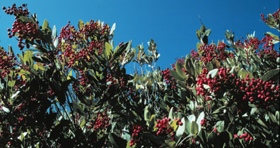
From that starting point, you head crookedly north through weedy grasses, more or less parallel to Las Virgenes Road. After a not-too-promising half mile, the scenery improves greatly as the trail cuts east across a lushly vegetated, north-facing slope, gains elevation, and pulls away from the somewhat noisy sounds of traffic. Here, you can enjoy the cool shade, surrounded at close range by dense chaparral vegetation. Look for the red berries of the toyon plant, which here in the Santa Monica Mountains sometimes attains the stature of a small tree. Toyon’s aliases include “Christmas berry” and “California holly.”
Before long, you’re curling uphill on an oak-dotted ridge and enjoying ever-widening views. At the top of that ridge, the trail turns south and meanders over to an 1100-foot-elevation knoll that serves as an informal viewpoint. There, you can look out over the Las Virgenes Creek floodplain, flanked by sensuously rolling hills, and spot various high points in the Santa Monica Mountains: Saddle Peak, Goat Buttes, Castro Crest, and San Vicente Mountain (with its signature abandoned Nike missile base). Much of the territory to the west and south lies in Malibu Creek State Park, used for decades as an outdoor set for dozens of movie and television productions.
When it’s time to go, retrace your steps, and enjoy the benefit of mostly downhill travel.
This article contains information about a publicly owned recreation or wilderness area. Trails and pathways are not necessarily marked. Conditions can change rapidly. Hikers should be properly equipped and have safety and navigational skills. The Reader and Jerry Schad assume no responsibility for any adverse experience.
Upper Las Virgenes View Trail
View the upper reaches of Malibu Canyon from a newer trail in the Santa Monica Mountains.
Distance from downtown San Diego: 154 miles
Hiking length: 4.0 miles round trip
Difficulty: Moderate