Here's something you might be interested in.
Ask a Hipster — Advice you didn't know you needed
Big Screen — Movie commentary
Blurt — Music's inside track
Booze News — San Diego spirits
Classical Music — Immortal beauty
Classifieds — Free and easy
Cover Stories — Front-page features
Drinks All Around — Bartenders' drink recipes
Excerpts — Literary and spiritual excerpts
Feast! — Food & drink reviews
Feature Stories — Local news & stories
Fishing Report — What’s getting hooked from ship and shore
From the Archives — Spotlight on the past
Golden Dreams — Talk of the town
The Gonzo Report — Making the musical scene, or at least reporting from it
Letters — Our inbox
Movies@Home — Local movie buffs share favorites
Movie Reviews — Our critics' picks and pans
Musician Interviews — Up close with local artists
Neighborhood News from Stringers — Hyperlocal news
News Ticker — News & politics
Obermeyer — San Diego politics illustrated
Outdoors — Weekly changes in flora and fauna
Overheard in San Diego — Eavesdropping illustrated
Poetry — The old and the new
Reader Travel — Travel section built by travelers
Reading — The hunt for intellectuals
Roam-O-Rama — SoCal's best hiking/biking trails
San Diego Beer — Inside San Diego suds
SD on the QT — Almost factual news
Sheep and Goats — Places of worship
Special Issues — The best of
Street Style — San Diego streets have style
Surf Diego — Real stories from those braving the waves
Theater — On stage in San Diego this week
Tin Fork — Silver spoon alternative
Under the Radar — Matt Potter's undercover work
Unforgettable — Long-ago San Diego
Unreal Estate — San Diego's priciest pads
Your Week — Daily event picks
Flat Cat Canyon
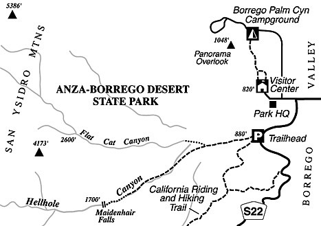
Flat Cat Canyon is the curious name given to a rugged gorge southwest of the Anza-Borrego Desert State Park visitor center and not far outside the community of Borrego Springs. Park rangers once found a dead bobcat (presumably very dead) in this canyon and followed the honorable Western tradition of assigning colorful names to colorful places. From down below, Flat Cat Canyon appears as a steep, boulder-choked ravine — of keen interest perhaps to coyotes and bobcats, but seemingly of little interest to humans. The canyon’s upper reaches, though, hold a surprise or two.
Should you decide to nose your weary way up this canyon, wear long pants and sturdy shoes to help protect you from the needling of cactus spines and the invasive thrusts of catclaw and desert apricot thorns. Serious bushwhacking and rock-scrambling challenges await you, so forget it if you’re not ready for a sweaty affair that may involve some frustration with the sometimes-glacial rate of progress. Need we say you are going to need sturdy footwear, as well as drinking water?
To get to the starting point from Borrego Springs, follow Palm Canyon Drive (Highway S-22) west to Montezuma Highway and turn left, remaining on S-22. Continue 0.7 mile to the large trailhead parking area on the west side of Montezuma Highway. If you’re arriving from the west, this trailhead is located near the bottom of the twisting Montezuma Grade, at mile marker 16.5.
From the trailhead, follow the trail leading west, straight toward the wide mouth of Hellhole Canyon — but leave this trail and bend right toward Flat Cat Canyon (which is the narrower and steeper canyon to the north of Hellhole Canyon) after about a mile. Once you get into Flat Cat Canyon, your first mile of travel, partly on a sandy wash and partly over the rocks of the canyon walls, nets you about 1000 feet of elevation. Take note of the contrast between the dark, desert-varnished rock high on the canyonsides, and the whitish, flood-scoured boulders on the lower slopes. Past the first scattered California fan palm trees (our local desert’s native palms), notice on the north side of the canyon a nice example of exfoliation in granitic rock. Physical and chemical weathering has broken up the rock into concentric layers, resembling those of an onion.
If your stamina and patience allow, continue scrambling uphill, past more palms and trickles or riffles of water (depending on the amount of recent rainfall), to a place where Flat Cat Canyon evenly divides at 2600 feet elevation. The canyon’s largest grove of about two dozen palms resides here. At that point you’ve come 2.5 miles in all and gained 1800 feet of elevation. Return the same way you came. Enjoy the spacious view of the desert floor, spreading east and framed by the canyon’s V-shaped profile, on your descent back to the starting point.
This article contains information about a publicly owned recreation or wilderness area. Trails and pathways are not necessarily marked. Conditions can change rapidly. Hikers should be properly equipped and have safety and navigational skills. The Reader and Jerry Schad assume no responsibility for any adverse experience.
Flat Cat Canyon
Do battle with steep terrain and spiny vegetation in Anza-Borrego’s Flat Cat Canyon.
Distance from downtown San Diego: 90 miles
Hiking length: 5 miles (round trip)
Difficulty: Strenuous
Here's something you might be interested in.
Flat Cat Canyon
Flat Cat Canyon
Flat Cat Canyon is the curious name given to a rugged gorge southwest of the Anza-Borrego Desert State Park visitor center and not far outside the community of Borrego Springs. Park rangers once found a dead bobcat (presumably very dead) in this canyon and followed the honorable Western tradition of assigning colorful names to colorful places. From down below, Flat Cat Canyon appears as a steep, boulder-choked ravine — of keen interest perhaps to coyotes and bobcats, but seemingly of little interest to humans. The canyon’s upper reaches, though, hold a surprise or two.
Should you decide to nose your weary way up this canyon, wear long pants and sturdy shoes to help protect you from the needling of cactus spines and the invasive thrusts of catclaw and desert apricot thorns. Serious bushwhacking and rock-scrambling challenges await you, so forget it if you’re not ready for a sweaty affair that may involve some frustration with the sometimes-glacial rate of progress. Need we say you are going to need sturdy footwear, as well as drinking water?
To get to the starting point from Borrego Springs, follow Palm Canyon Drive (Highway S-22) west to Montezuma Highway and turn left, remaining on S-22. Continue 0.7 mile to the large trailhead parking area on the west side of Montezuma Highway. If you’re arriving from the west, this trailhead is located near the bottom of the twisting Montezuma Grade, at mile marker 16.5.
From the trailhead, follow the trail leading west, straight toward the wide mouth of Hellhole Canyon — but leave this trail and bend right toward Flat Cat Canyon (which is the narrower and steeper canyon to the north of Hellhole Canyon) after about a mile. Once you get into Flat Cat Canyon, your first mile of travel, partly on a sandy wash and partly over the rocks of the canyon walls, nets you about 1000 feet of elevation. Take note of the contrast between the dark, desert-varnished rock high on the canyonsides, and the whitish, flood-scoured boulders on the lower slopes. Past the first scattered California fan palm trees (our local desert’s native palms), notice on the north side of the canyon a nice example of exfoliation in granitic rock. Physical and chemical weathering has broken up the rock into concentric layers, resembling those of an onion.
If your stamina and patience allow, continue scrambling uphill, past more palms and trickles or riffles of water (depending on the amount of recent rainfall), to a place where Flat Cat Canyon evenly divides at 2600 feet elevation. The canyon’s largest grove of about two dozen palms resides here. At that point you’ve come 2.5 miles in all and gained 1800 feet of elevation. Return the same way you came. Enjoy the spacious view of the desert floor, spreading east and framed by the canyon’s V-shaped profile, on your descent back to the starting point.
This article contains information about a publicly owned recreation or wilderness area. Trails and pathways are not necessarily marked. Conditions can change rapidly. Hikers should be properly equipped and have safety and navigational skills. The Reader and Jerry Schad assume no responsibility for any adverse experience.
Flat Cat Canyon
Do battle with steep terrain and spiny vegetation in Anza-Borrego’s Flat Cat Canyon.
Distance from downtown San Diego: 90 miles
Hiking length: 5 miles (round trip)
Difficulty: Strenuous