Here's something you might be interested in.
Ask a Hipster — Advice you didn't know you needed
Big Screen — Movie commentary
Blurt — Music's inside track
Booze News — San Diego spirits
Classical Music — Immortal beauty
Classifieds — Free and easy
Cover Stories — Front-page features
Drinks All Around — Bartenders' drink recipes
Excerpts — Literary and spiritual excerpts
Feast! — Food & drink reviews
Feature Stories — Local news & stories
Fishing Report — What’s getting hooked from ship and shore
From the Archives — Spotlight on the past
Golden Dreams — Talk of the town
The Gonzo Report — Making the musical scene, or at least reporting from it
Letters — Our inbox
Movies@Home — Local movie buffs share favorites
Movie Reviews — Our critics' picks and pans
Musician Interviews — Up close with local artists
Neighborhood News from Stringers — Hyperlocal news
News Ticker — News & politics
Obermeyer — San Diego politics illustrated
Outdoors — Weekly changes in flora and fauna
Overheard in San Diego — Eavesdropping illustrated
Poetry — The old and the new
Reader Travel — Travel section built by travelers
Reading — The hunt for intellectuals
Roam-O-Rama — SoCal's best hiking/biking trails
San Diego Beer — Inside San Diego suds
SD on the QT — Almost factual news
Sheep and Goats — Places of worship
Special Issues — The best of
Street Style — San Diego streets have style
Surf Diego — Real stories from those braving the waves
Theater — On stage in San Diego this week
Tin Fork — Silver spoon alternative
Under the Radar — Matt Potter's undercover work
Unforgettable — Long-ago San Diego
Unreal Estate — San Diego's priciest pads
Your Week — Daily event picks
Punta Mesa Loop
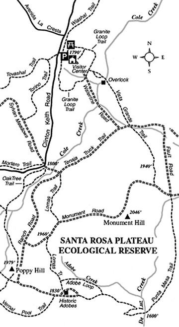
Clear, late-autumn skies and cool temperatures inland beckon you to visit southwest Riverside County’s premier ecological showplace: Santa Rosa Plateau Ecological Reserve. The leisurely half-day Punta Mesa loop hike will introduce you to virtually every attractive natural feature characteristic of Southern California’s foothills. Note that the level of protection is higher here than in many other open-space venues; neither dogs or mountain bikes are allowed on this particular route.
To get there from San Diego, head north on Interstate 15 into Riverside County. Beyond Temecula, stay left on I-15 as you approach the I-15/I-215 split. Proceed about five miles farther to the Clinton Keith Road exit in Murrieta. Then go south on Clinton Keith Road five miles to the Santa Rosa Plateau visitor center, on the left. There’s a small charge for parking here.
From the visitor center parking lot, follow the dirt road going southeast — Waterline Road. At 0.8 mile, turn right on Tenaja Truck Trail and traverse its flat, straight course across a treeless plain. At 1.7 mile, near the junction of Ranch House Road, make a left on the narrow Lomas Trail. Ascend a slope dotted with Engelmann oaks, jog right for about 0.2 mile on Monument Road, and then find the continuation of Lomas Trail on the left. You now make a descent into a valley, where the Adobe Loop trail branches left, and two adobe buildings set amid towering oaks lie just ahead. Those are the adobes of the former Santa Rosa Ranch, and you won’t want to miss visiting them. Constructed around 1845, they are Riverside County’s oldest standing structures. Your hike has taken you three miles so far.
After a look at the adobes and a refreshing pause in the shade (if it happens to be a warm Santa Ana day), backtrack 0.1 mile north on Lomas Trail and take the Adobe Loop trail east, down along an oak-filled canyon. Enjoy the last deeply shaded stretch of trail you’re going to get on this hike. Soon enough, it’s back into the sunshine again as you climb up to a junction with the Punta Mesa Trail. Turn left and follow this deteriorating former fire road a total of two miles — down across De Luz Creek and back uphill, heading north. Flat-topped Mesa de la Punta rises to the south, and Mesa de Burro rises in the east. Both are capped with erosion-resistant basalt, representing some the rarer volcanic features around Southern California.
At the next intersection (a total of 5.8 miles into the hike), turn left on Monument Road, travel 0.2 mile west, and veer right on the aptly named Vista Grande Trail. Follow Vista Grande Trail north to a crest (elevation 1940 feet), where your gaze takes in hundreds of acres of wind-rippled grass and the distant, winter-snow-capped San Bernardino and San Jacinto mountains. Curving northwest, the Vista Grande Trail crosses Tenaja Truck Trail and then more or less makes a beeline for the visitor center, traversing near-flat terrain punctuated with scattered oaks and lichen-encrusted piles of granitic rock.
This article contains information about a publicly owned recreation or wilderness area. Trails and pathways are not necessarily marked. Conditions can change rapidly. Hikers should be properly equipped and have safety and navigational skills. The Reader and Jerry Schad assume no responsibility for any adverse experience.
Punta Mesa Loop
Take a comprehensive hiking tour of Temecula’s Santa Rosa Plateau Ecological Reserve.
Distance from downtown San Diego: 72 miles
Hiking length: 8 miles
Difficulty: Moderately strenuous
Here's something you might be interested in.
Punta Mesa Loop
Punta Mesa Loop
Clear, late-autumn skies and cool temperatures inland beckon you to visit southwest Riverside County’s premier ecological showplace: Santa Rosa Plateau Ecological Reserve. The leisurely half-day Punta Mesa loop hike will introduce you to virtually every attractive natural feature characteristic of Southern California’s foothills. Note that the level of protection is higher here than in many other open-space venues; neither dogs or mountain bikes are allowed on this particular route.
To get there from San Diego, head north on Interstate 15 into Riverside County. Beyond Temecula, stay left on I-15 as you approach the I-15/I-215 split. Proceed about five miles farther to the Clinton Keith Road exit in Murrieta. Then go south on Clinton Keith Road five miles to the Santa Rosa Plateau visitor center, on the left. There’s a small charge for parking here.
From the visitor center parking lot, follow the dirt road going southeast — Waterline Road. At 0.8 mile, turn right on Tenaja Truck Trail and traverse its flat, straight course across a treeless plain. At 1.7 mile, near the junction of Ranch House Road, make a left on the narrow Lomas Trail. Ascend a slope dotted with Engelmann oaks, jog right for about 0.2 mile on Monument Road, and then find the continuation of Lomas Trail on the left. You now make a descent into a valley, where the Adobe Loop trail branches left, and two adobe buildings set amid towering oaks lie just ahead. Those are the adobes of the former Santa Rosa Ranch, and you won’t want to miss visiting them. Constructed around 1845, they are Riverside County’s oldest standing structures. Your hike has taken you three miles so far.
After a look at the adobes and a refreshing pause in the shade (if it happens to be a warm Santa Ana day), backtrack 0.1 mile north on Lomas Trail and take the Adobe Loop trail east, down along an oak-filled canyon. Enjoy the last deeply shaded stretch of trail you’re going to get on this hike. Soon enough, it’s back into the sunshine again as you climb up to a junction with the Punta Mesa Trail. Turn left and follow this deteriorating former fire road a total of two miles — down across De Luz Creek and back uphill, heading north. Flat-topped Mesa de la Punta rises to the south, and Mesa de Burro rises in the east. Both are capped with erosion-resistant basalt, representing some the rarer volcanic features around Southern California.
At the next intersection (a total of 5.8 miles into the hike), turn left on Monument Road, travel 0.2 mile west, and veer right on the aptly named Vista Grande Trail. Follow Vista Grande Trail north to a crest (elevation 1940 feet), where your gaze takes in hundreds of acres of wind-rippled grass and the distant, winter-snow-capped San Bernardino and San Jacinto mountains. Curving northwest, the Vista Grande Trail crosses Tenaja Truck Trail and then more or less makes a beeline for the visitor center, traversing near-flat terrain punctuated with scattered oaks and lichen-encrusted piles of granitic rock.
This article contains information about a publicly owned recreation or wilderness area. Trails and pathways are not necessarily marked. Conditions can change rapidly. Hikers should be properly equipped and have safety and navigational skills. The Reader and Jerry Schad assume no responsibility for any adverse experience.
Punta Mesa Loop
Take a comprehensive hiking tour of Temecula’s Santa Rosa Plateau Ecological Reserve.
Distance from downtown San Diego: 72 miles
Hiking length: 8 miles
Difficulty: Moderately strenuous