Here's something you might be interested in.
Ask a Hipster — Advice you didn't know you needed
Big Screen — Movie commentary
Blurt — Music's inside track
Booze News — San Diego spirits
Classical Music — Immortal beauty
Classifieds — Free and easy
Cover Stories — Front-page features
Drinks All Around — Bartenders' drink recipes
Excerpts — Literary and spiritual excerpts
Feast! — Food & drink reviews
Feature Stories — Local news & stories
Fishing Report — What’s getting hooked from ship and shore
From the Archives — Spotlight on the past
Golden Dreams — Talk of the town
The Gonzo Report — Making the musical scene, or at least reporting from it
Letters — Our inbox
Movies@Home — Local movie buffs share favorites
Movie Reviews — Our critics' picks and pans
Musician Interviews — Up close with local artists
Neighborhood News from Stringers — Hyperlocal news
News Ticker — News & politics
Obermeyer — San Diego politics illustrated
Outdoors — Weekly changes in flora and fauna
Overheard in San Diego — Eavesdropping illustrated
Poetry — The old and the new
Reader Travel — Travel section built by travelers
Reading — The hunt for intellectuals
Roam-O-Rama — SoCal's best hiking/biking trails
San Diego Beer — Inside San Diego suds
SD on the QT — Almost factual news
Sheep and Goats — Places of worship
Special Issues — The best of
Street Style — San Diego streets have style
Surf Diego — Real stories from those braving the waves
Theater — On stage in San Diego this week
Tin Fork — Silver spoon alternative
Under the Radar — Matt Potter's undercover work
Unforgettable — Long-ago San Diego
Unreal Estate — San Diego's priciest pads
Your Week — Daily event picks
Cobal Canyon Loop
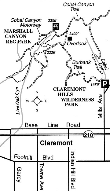
Adjoining the vast spaces of Angeles National Forest, Claremont Hills Wilderness Park spreads over foothills spilling down toward the college town of Claremont. The Cobal Canyon Loop, the one significant hike in the park that it seems nearly everyone in and around Claremont likes to take, is particularly rewarding in the green and flowery month of April. The route is entirely on wide fire roads, so there’s plenty of room for leashed dogs and mountain bikes, as well as walkers and runners.
Exit the 210 Freeway at Baseline Road on the border between the cities of Claremont and Upland. Go west on Baseline for 0.7 mile, then turn right (north) on Mills Avenue. After 1.1 mile the main road (signed Mount Baldy Road) veers sharply right, while the dead-end Mills Avenue continues straight. Follow Mills Avenue to its end, which is where you find the trailhead for Claremont Hills Wilderness Park.
From the trailhead parking area, proceed up the bottom of Cobal Canyon on the Cobal Canyon Trail (a.k.a. Cobal Canyon Motorway). You quickly plunge into the deep shade of coast live oaks, the survivors of repeated wildfires, including the 2003 Grand Prix Fire. Large brown mileage signs tick off the half-miles along the route, but they count backward from 5.0 on the counterclockwise loop you are following. This direction is preferred, since you get to go uphill and slower on the more scenic Cobal Canyon piece of the loop.
By 1.0 mile you’re rounding a horseshoe curve and climbing out of Cobal Canyon. Looking back you can see a handful of bigcone Douglas-firs clinging to the north-facing slope. They are about as low (1800 feet in elevation) as these evergreen trees can grow in their native habitat.
Continue a steady climb on sunny slopes to an unmarked fire road on the right (1.8 miles) which connects with fire roads in Angeles National Forest. Stay left. After another half mile of climbing you reach a crest; right afterward there’s another fire road (the continuation of Cobal Canyon Motorway) branching right (2.5 miles). This leads to the fire roads and trails of adjacent Marshall Canyon Regional Park. Stay left again.
Just ahead, off to the left side, is an elaborate shade ramada perched atop a knoll for maximum panoramic impact. The view from there stretches from the relatively nearby summit of Mount San Antonio to distant features such as San Jacinto Peak, the Santa Ana Mountains, and Santa Catalina Island.
The remainder of the loop hike is somewhat anticlimactic. Continue south along the fire road, ignoring yet another wide fire road on the right that leads toward Marshall Canyon Regional Park. Stay with the main, undulating ridge on the wide, south-going fire road called Burbank Trail (aka Burbank Motorway), and stick with that route as it curls down dry, brushy slopes overlooking Burbank Canyon. At 5.0 miles you arrive back in Cobal Canyon very close to the trailhead parking lot.
This article contains information about a publicly owned recreation or wilderness area. Trails and pathways are not necessarily marked. Conditions can change rapidly. Hikers should be properly equipped and have safety and navigational skills. The Reader and Jerry Schad assume no responsibility for any adverse experience.
Cobal Canyon Loop
Hike or bike Claremont Hills Wilderness Park in the foothills of the San Gabriel Mountains.
Distance from downtown San Diego: 126 miles
Hiking length: 5.0 miles
Difficulty: Moderate
Here's something you might be interested in.
Cobal Canyon Loop
Cobal Canyon Loop
Adjoining the vast spaces of Angeles National Forest, Claremont Hills Wilderness Park spreads over foothills spilling down toward the college town of Claremont. The Cobal Canyon Loop, the one significant hike in the park that it seems nearly everyone in and around Claremont likes to take, is particularly rewarding in the green and flowery month of April. The route is entirely on wide fire roads, so there’s plenty of room for leashed dogs and mountain bikes, as well as walkers and runners.
Exit the 210 Freeway at Baseline Road on the border between the cities of Claremont and Upland. Go west on Baseline for 0.7 mile, then turn right (north) on Mills Avenue. After 1.1 mile the main road (signed Mount Baldy Road) veers sharply right, while the dead-end Mills Avenue continues straight. Follow Mills Avenue to its end, which is where you find the trailhead for Claremont Hills Wilderness Park.
From the trailhead parking area, proceed up the bottom of Cobal Canyon on the Cobal Canyon Trail (a.k.a. Cobal Canyon Motorway). You quickly plunge into the deep shade of coast live oaks, the survivors of repeated wildfires, including the 2003 Grand Prix Fire. Large brown mileage signs tick off the half-miles along the route, but they count backward from 5.0 on the counterclockwise loop you are following. This direction is preferred, since you get to go uphill and slower on the more scenic Cobal Canyon piece of the loop.
By 1.0 mile you’re rounding a horseshoe curve and climbing out of Cobal Canyon. Looking back you can see a handful of bigcone Douglas-firs clinging to the north-facing slope. They are about as low (1800 feet in elevation) as these evergreen trees can grow in their native habitat.
Continue a steady climb on sunny slopes to an unmarked fire road on the right (1.8 miles) which connects with fire roads in Angeles National Forest. Stay left. After another half mile of climbing you reach a crest; right afterward there’s another fire road (the continuation of Cobal Canyon Motorway) branching right (2.5 miles). This leads to the fire roads and trails of adjacent Marshall Canyon Regional Park. Stay left again.
Just ahead, off to the left side, is an elaborate shade ramada perched atop a knoll for maximum panoramic impact. The view from there stretches from the relatively nearby summit of Mount San Antonio to distant features such as San Jacinto Peak, the Santa Ana Mountains, and Santa Catalina Island.
The remainder of the loop hike is somewhat anticlimactic. Continue south along the fire road, ignoring yet another wide fire road on the right that leads toward Marshall Canyon Regional Park. Stay with the main, undulating ridge on the wide, south-going fire road called Burbank Trail (aka Burbank Motorway), and stick with that route as it curls down dry, brushy slopes overlooking Burbank Canyon. At 5.0 miles you arrive back in Cobal Canyon very close to the trailhead parking lot.
This article contains information about a publicly owned recreation or wilderness area. Trails and pathways are not necessarily marked. Conditions can change rapidly. Hikers should be properly equipped and have safety and navigational skills. The Reader and Jerry Schad assume no responsibility for any adverse experience.
Cobal Canyon Loop
Hike or bike Claremont Hills Wilderness Park in the foothills of the San Gabriel Mountains.
Distance from downtown San Diego: 126 miles
Hiking length: 5.0 miles
Difficulty: Moderate