Here's something you might be interested in.
Ask a Hipster — Advice you didn't know you needed
Big Screen — Movie commentary
Blurt — Music's inside track
Booze News — San Diego spirits
Classical Music — Immortal beauty
Classifieds — Free and easy
Cover Stories — Front-page features
Drinks All Around — Bartenders' drink recipes
Excerpts — Literary and spiritual excerpts
Feast! — Food & drink reviews
Feature Stories — Local news & stories
Fishing Report — What’s getting hooked from ship and shore
From the Archives — Spotlight on the past
Golden Dreams — Talk of the town
The Gonzo Report — Making the musical scene, or at least reporting from it
Letters — Our inbox
Movies@Home — Local movie buffs share favorites
Movie Reviews — Our critics' picks and pans
Musician Interviews — Up close with local artists
Neighborhood News from Stringers — Hyperlocal news
News Ticker — News & politics
Obermeyer — San Diego politics illustrated
Outdoors — Weekly changes in flora and fauna
Overheard in San Diego — Eavesdropping illustrated
Poetry — The old and the new
Reader Travel — Travel section built by travelers
Reading — The hunt for intellectuals
Roam-O-Rama — SoCal's best hiking/biking trails
San Diego Beer — Inside San Diego suds
SD on the QT — Almost factual news
Sheep and Goats — Places of worship
Special Issues — The best of
Street Style — San Diego streets have style
Surf Diego — Real stories from those braving the waves
Theater — On stage in San Diego this week
Tin Fork — Silver spoon alternative
Under the Radar — Matt Potter's undercover work
Unforgettable — Long-ago San Diego
Unreal Estate — San Diego's priciest pads
Your Week — Daily event picks
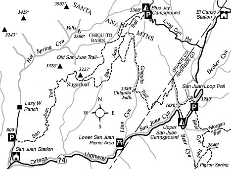
San Juan Trail
With gentle grades most of the way, the San Juan Trail is tailor-made for a leisurely saunter from the Main Divide of the Santa Ana Mountains to the lower foothills. Due to an elevation change of about 2500 feet, most of the spring wildflowers common to the chaparral and sage-scrub plant communities can be seen somewhere along this trail during the month of April. If the day is very clear, the distant views you enjoy will include much of the southern Orange County coastline, plus Santa Catalina and San Clemente islands.
If you choose to travel the 11-mile-long trail in a one-way direction, you’ll need some kind of arrangement for transportation. The lower trailhead lies in Hot Spring Canyon, 0.8 mile north of the San Juan Fire Station on Highway 74 (east of San Juan Capistrano). The upper trailhead (the preferred starting point if you like downhill travel) lies just south of the entrance to Blue Jay Campground, a major camping area. Any car parked at either trailhead must have a National Forest Adventure Pass displayed.
From the upper trailhead, the San Juan Trail winds west and south along a hillside, just below the level of the campground. After a mile, the trail starts descending along a sunny, sage-carpeted slope. At 1.3 miles the trail crosses an older version of the San Juan Trail (a steep, rocky roadbed) and plunges into the deep shade of a ravine. For a time, live oaks keep the sun’s rays at bay.
After rounding a single switchback and descending further, you reach, in a sunny, sage-dotted clearing at 1.7 miles, a second crossing of the old trail. Keep straight and you come to a junction at 1.8 miles with the Chiquito Trail. Stay right here.
Continue south along the base of a hillside, through chaparral growth. Climbing slightly into a more sparsely vegetated zone, you arrive (2.4 miles) at another junction, where the San Juan Trail bends right to cross the top of a gentle divide, and the Viejo Tie Trail, on the left, goes along the hillside.
Stay on the San Juan Trail, which now bears south-southwest through more chaparral. Reaching some oaks in a ravine bottom (3.7 miles), the trail zigzags a couple of times through grass and poison oak and crosses an intermittent stream. Enjoy the shade, because this is the last grove of trees until you reach the end of the trail.
On the far side of the ravine, the trail swings south of a small peak and then climbs moderately toward a flat area (5.0 miles) just south of Sugarloaf peak, where the old trail, a rutted firebreak at this point, comes in from the right. After dropping down along the west slope of Sugarloaf, you come to a saddle overlooking steep Hot Spring Canyon to the north.
The gradual descent continues, largely on or near the spine of a ridge offering nice views of other ridges and canyons in every direction. Far below to the south, the gray blacktop of Ortega Highway resembles a giant snake propelling itself through the sycamores in San Juan Canyon.
At around 8.5 miles, several switchbacks take you safely down a crumbling slope. At 10.0 miles, with only a mile to go, you begin descending quickly. A final set of zigzags takes you down into Hot Spring Canyon, where the trail intersects the road coming up from San Juan Fire Station.
This article contains information about a publicly owned recreation or wilderness area. Trails and pathways are not necessarily marked. Conditions can change rapidly. Hikers should be properly equipped and have safety and navigational skills. The Reader and Jerry Schad assume no responsibility for any adverse experience.
San Juan Trail
Hike or bike the San Juan Trail in Orange County’s Santa Ana Mountains.
Distance from downtown San Diego: 86 miles
Hiking/biking length: 11 miles
Difficulty: Moderately strenuous
Here's something you might be interested in.
San Juan Trail
San Juan Trail
With gentle grades most of the way, the San Juan Trail is tailor-made for a leisurely saunter from the Main Divide of the Santa Ana Mountains to the lower foothills. Due to an elevation change of about 2500 feet, most of the spring wildflowers common to the chaparral and sage-scrub plant communities can be seen somewhere along this trail during the month of April. If the day is very clear, the distant views you enjoy will include much of the southern Orange County coastline, plus Santa Catalina and San Clemente islands.
If you choose to travel the 11-mile-long trail in a one-way direction, you’ll need some kind of arrangement for transportation. The lower trailhead lies in Hot Spring Canyon, 0.8 mile north of the San Juan Fire Station on Highway 74 (east of San Juan Capistrano). The upper trailhead (the preferred starting point if you like downhill travel) lies just south of the entrance to Blue Jay Campground, a major camping area. Any car parked at either trailhead must have a National Forest Adventure Pass displayed.
From the upper trailhead, the San Juan Trail winds west and south along a hillside, just below the level of the campground. After a mile, the trail starts descending along a sunny, sage-carpeted slope. At 1.3 miles the trail crosses an older version of the San Juan Trail (a steep, rocky roadbed) and plunges into the deep shade of a ravine. For a time, live oaks keep the sun’s rays at bay.
After rounding a single switchback and descending further, you reach, in a sunny, sage-dotted clearing at 1.7 miles, a second crossing of the old trail. Keep straight and you come to a junction at 1.8 miles with the Chiquito Trail. Stay right here.
Continue south along the base of a hillside, through chaparral growth. Climbing slightly into a more sparsely vegetated zone, you arrive (2.4 miles) at another junction, where the San Juan Trail bends right to cross the top of a gentle divide, and the Viejo Tie Trail, on the left, goes along the hillside.
Stay on the San Juan Trail, which now bears south-southwest through more chaparral. Reaching some oaks in a ravine bottom (3.7 miles), the trail zigzags a couple of times through grass and poison oak and crosses an intermittent stream. Enjoy the shade, because this is the last grove of trees until you reach the end of the trail.
On the far side of the ravine, the trail swings south of a small peak and then climbs moderately toward a flat area (5.0 miles) just south of Sugarloaf peak, where the old trail, a rutted firebreak at this point, comes in from the right. After dropping down along the west slope of Sugarloaf, you come to a saddle overlooking steep Hot Spring Canyon to the north.
The gradual descent continues, largely on or near the spine of a ridge offering nice views of other ridges and canyons in every direction. Far below to the south, the gray blacktop of Ortega Highway resembles a giant snake propelling itself through the sycamores in San Juan Canyon.
At around 8.5 miles, several switchbacks take you safely down a crumbling slope. At 10.0 miles, with only a mile to go, you begin descending quickly. A final set of zigzags takes you down into Hot Spring Canyon, where the trail intersects the road coming up from San Juan Fire Station.
This article contains information about a publicly owned recreation or wilderness area. Trails and pathways are not necessarily marked. Conditions can change rapidly. Hikers should be properly equipped and have safety and navigational skills. The Reader and Jerry Schad assume no responsibility for any adverse experience.
San Juan Trail
Hike or bike the San Juan Trail in Orange County’s Santa Ana Mountains.
Distance from downtown San Diego: 86 miles
Hiking/biking length: 11 miles
Difficulty: Moderately strenuous