Here's something you might be interested in.
Ask a Hipster — Advice you didn't know you needed
Big Screen — Movie commentary
Blurt — Music's inside track
Booze News — San Diego spirits
Classical Music — Immortal beauty
Classifieds — Free and easy
Cover Stories — Front-page features
Drinks All Around — Bartenders' drink recipes
Excerpts — Literary and spiritual excerpts
Feast! — Food & drink reviews
Feature Stories — Local news & stories
Fishing Report — What’s getting hooked from ship and shore
From the Archives — Spotlight on the past
Golden Dreams — Talk of the town
The Gonzo Report — Making the musical scene, or at least reporting from it
Letters — Our inbox
Movies@Home — Local movie buffs share favorites
Movie Reviews — Our critics' picks and pans
Musician Interviews — Up close with local artists
Neighborhood News from Stringers — Hyperlocal news
News Ticker — News & politics
Obermeyer — San Diego politics illustrated
Outdoors — Weekly changes in flora and fauna
Overheard in San Diego — Eavesdropping illustrated
Poetry — The old and the new
Reader Travel — Travel section built by travelers
Reading — The hunt for intellectuals
Roam-O-Rama — SoCal's best hiking/biking trails
San Diego Beer — Inside San Diego suds
SD on the QT — Almost factual news
Sheep and Goats — Places of worship
Special Issues — The best of
Street Style — San Diego streets have style
Surf Diego — Real stories from those braving the waves
Theater — On stage in San Diego this week
Tin Fork — Silver spoon alternative
Under the Radar — Matt Potter's undercover work
Unforgettable — Long-ago San Diego
Unreal Estate — San Diego's priciest pads
Your Week — Daily event picks
Oat Mountain
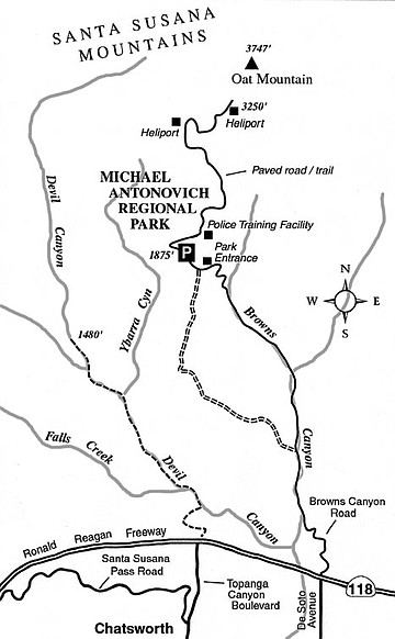
A rambling patch of newly acquired open space that goes by the long-winded name of Michael D. Antonovich Regional Park at Joughin Ranch spreads over a south-facing slope that culminates in a 3747-foot summit called Oat Mountain. On this trip, you drive about halfway up the mountain (as measured from the San Fernando Valley floor) and travel on foot or by low-gear bike most of the remaining distance to Oat Mountain, which technically lies on private property. Hopefully you’ll take the trip on a clear day, when the ever-widening view gets ever more stupendous as you climb.
To get to the trailhead, exit the 118 Freeway at De Soto Avenue in Chatsworth. The northern extension of De Soto is called Browns Canyon Road. Follow this narrow, twisty road around some outlying houses, up along the Browns Canyon stream, and finally up a steep hill to the main Antonovich Park entrance. There’s a lower parking lot on the left, but continue about 0.4 mile farther to an large upper lot just shy of where the road is blocked to public traffic.
Now you’re ready to trudge on, uphill and sometimes very steeply so, on the same road. By 0.5 mile, you’re passing the various buildings of a Los Angeles Police Department training facility, and the sharp increase in elevation gain so far has yielded a significantly wider panorama of the vast, flat, and densely populated San Fernando Valley below. Above the training facility, the close-at-hand landscape assumes a more impressive character, with wild grasses — mostly wild oats, after which the peak above was named — chafing in the breezes of this current dry season, or bending in a supple fashion in the zephyrs of springtime.
At 1.0 mile you traverse a cattle grate and temporarily enter a parcel where cattle graze contentedly. Soon, after crossing a second grate, you’re back in Antonovich parkland, where the ascent quickens. The valley view to the south now assumes a pseudo-aerial character, and the green or golden (depending on the season) slopes seem to roll sensuously upward, downward, and sideways.
At 2.0 miles, alongside a heliport (a large flat spot for fire-fighting helicopters to land), you start to get a view to the north, which consists of miles of ridges sparsely dotted with valley oaks, and an occasional rocker pump struggling to extract the very last drop of crude oil remaining in the permeable strata far below.
Keep going a bit farther to a second heliport, this one on the right, which offers perhaps the most comprehensive vista so far. After contemplating the scene and taking a deep pull from your water bottle, it’s time to return, using the same route.
This article contains information about a publicly owned recreation or wilderness area. Trails and pathways are not necessarily marked. Conditions can change rapidly. Hikers should be properly equipped and have safety and navigational skills. The Reader and Jerry Schad assume no responsibility for any adverse experience.
Oat Mountain
Climb Oat Mountain in the Santa Susana Mountains for a spacious view of the San Fernando Valley.
Distance from downtown San Diego: 152 miles
Hiking/biking length: 4.6 miles round trip
Difficulty: Moderately strenuous
Here's something you might be interested in.
Oat Mountain
Oat Mountain
A rambling patch of newly acquired open space that goes by the long-winded name of Michael D. Antonovich Regional Park at Joughin Ranch spreads over a south-facing slope that culminates in a 3747-foot summit called Oat Mountain. On this trip, you drive about halfway up the mountain (as measured from the San Fernando Valley floor) and travel on foot or by low-gear bike most of the remaining distance to Oat Mountain, which technically lies on private property. Hopefully you’ll take the trip on a clear day, when the ever-widening view gets ever more stupendous as you climb.
To get to the trailhead, exit the 118 Freeway at De Soto Avenue in Chatsworth. The northern extension of De Soto is called Browns Canyon Road. Follow this narrow, twisty road around some outlying houses, up along the Browns Canyon stream, and finally up a steep hill to the main Antonovich Park entrance. There’s a lower parking lot on the left, but continue about 0.4 mile farther to an large upper lot just shy of where the road is blocked to public traffic.
Now you’re ready to trudge on, uphill and sometimes very steeply so, on the same road. By 0.5 mile, you’re passing the various buildings of a Los Angeles Police Department training facility, and the sharp increase in elevation gain so far has yielded a significantly wider panorama of the vast, flat, and densely populated San Fernando Valley below. Above the training facility, the close-at-hand landscape assumes a more impressive character, with wild grasses — mostly wild oats, after which the peak above was named — chafing in the breezes of this current dry season, or bending in a supple fashion in the zephyrs of springtime.
At 1.0 mile you traverse a cattle grate and temporarily enter a parcel where cattle graze contentedly. Soon, after crossing a second grate, you’re back in Antonovich parkland, where the ascent quickens. The valley view to the south now assumes a pseudo-aerial character, and the green or golden (depending on the season) slopes seem to roll sensuously upward, downward, and sideways.
At 2.0 miles, alongside a heliport (a large flat spot for fire-fighting helicopters to land), you start to get a view to the north, which consists of miles of ridges sparsely dotted with valley oaks, and an occasional rocker pump struggling to extract the very last drop of crude oil remaining in the permeable strata far below.
Keep going a bit farther to a second heliport, this one on the right, which offers perhaps the most comprehensive vista so far. After contemplating the scene and taking a deep pull from your water bottle, it’s time to return, using the same route.
This article contains information about a publicly owned recreation or wilderness area. Trails and pathways are not necessarily marked. Conditions can change rapidly. Hikers should be properly equipped and have safety and navigational skills. The Reader and Jerry Schad assume no responsibility for any adverse experience.
Oat Mountain
Climb Oat Mountain in the Santa Susana Mountains for a spacious view of the San Fernando Valley.
Distance from downtown San Diego: 152 miles
Hiking/biking length: 4.6 miles round trip
Difficulty: Moderately strenuous