Here's something you might be interested in.
Ask a Hipster — Advice you didn't know you needed
Big Screen — Movie commentary
Blurt — Music's inside track
Booze News — San Diego spirits
Classical Music — Immortal beauty
Classifieds — Free and easy
Cover Stories — Front-page features
Drinks All Around — Bartenders' drink recipes
Excerpts — Literary and spiritual excerpts
Feast! — Food & drink reviews
Feature Stories — Local news & stories
Fishing Report — What’s getting hooked from ship and shore
From the Archives — Spotlight on the past
Golden Dreams — Talk of the town
The Gonzo Report — Making the musical scene, or at least reporting from it
Letters — Our inbox
Movies@Home — Local movie buffs share favorites
Movie Reviews — Our critics' picks and pans
Musician Interviews — Up close with local artists
Neighborhood News from Stringers — Hyperlocal news
News Ticker — News & politics
Obermeyer — San Diego politics illustrated
Outdoors — Weekly changes in flora and fauna
Overheard in San Diego — Eavesdropping illustrated
Poetry — The old and the new
Reader Travel — Travel section built by travelers
Reading — The hunt for intellectuals
Roam-O-Rama — SoCal's best hiking/biking trails
San Diego Beer — Inside San Diego suds
SD on the QT — Almost factual news
Sheep and Goats — Places of worship
Special Issues — The best of
Street Style — San Diego streets have style
Surf Diego — Real stories from those braving the waves
Theater — On stage in San Diego this week
Tin Fork — Silver spoon alternative
Under the Radar — Matt Potter's undercover work
Unforgettable — Long-ago San Diego
Unreal Estate — San Diego's priciest pads
Your Week — Daily event picks
Big Laguna Trail
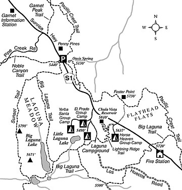
The six-mile-long Big Laguna Trail, high in the Laguna Mountains, wends its scenic way over gently rolling hills and grassy dales, never dipping below 5400 feet of elevation nor rising to more than 5900 feet. By combining the Big Laguna Trail (BLT) with a four-mile segment of the Pacific Crest Trail (PCT) as mapped here, you’ll complete a loop hike of ten miles with lots of varied scenery.
Mountain bikers can use the Big Laguna Trail portion of the route described here, but bikes are prohibited on all parts of the PCT (the PCT is reserved for hikers, horses, and dogs). On a bike, however, you could close and shorten the loop by riding on Sunrise Highway.
You can start at the Penny Pines parking area, mile 27.3 on Sunrise Highway, about four miles north of the village of Mount Laguna. Whether you park here or at any other spot along Sunrise Highway, you’ll need to post a National Forest Adventure Pass on your parked car. And don’t forget to take plenty of drinking water.
Start by heading west on the Noble Canyon Trail. After 0.1 mile, veer left on the BLT. After another 0.8 mile through open pine and oak woods, the BLT turns south to skirt the margin of Laguna Meadow. By 2.5 miles into the hike, you’ll be opposite Big Laguna Lake, which brims with water only during and for a few weeks after the rainy season of a typical year.
Next, the trail turns east toward an arm of Laguna Meadow that contains Little Laguna Lake (which is another ephemeral lake). When you reach a wire fence at 2.8 miles, don’t go through the gap in the fence. Instead, turn abruptly right and follow the fenceline over to the wooded area on the meadow’s east side. A spur trail branches left toward Laguna Campground, where water is available if you need it.
The main trail continues south along the meadow edge and then east to follow a shallow ravine. After a turn to the north and a short bit of steep climbing, you cross the graded Los Huecos Road (4.5 miles) and hook up with an old roadbed going east and later north. You ascend easily through chaparral highlighted by ceanothus, a.k.a. wild lilac.
When the old roadbed makes a hairpin turn to the right (at 5.0 miles), stay left on the footpath that continues through a gap in a wire fence. The path curls down through more pine and oak woods, crosses Sunrise Highway, and continues east, uphill, to join the PCT at 6.0 miles. Turn left there and return to your starting point by way of a rambling but scenic stretch of the PCT that follows the eastern escarpment of the Lagunas overlooking the Anza-Borrego desert.
This article contains information about a publicly owned recreation or wilderness area. Trails and pathways are not necessarily marked. Conditions can change rapidly. Hikers should be properly equipped and have safety and navigational skills. The Reader and Jerry Schad assume no responsibility for any adverse experience.
Big Laguna Trail
Hike through meadows and pine forests atop the mile-plus-high Laguna Mountain plateau.
Distance from downtown San Diego: 57 miles
Hiking length: 10 miles
Difficulty: Moderately strenuous
Here's something you might be interested in.
Big Laguna Trail
Big Laguna Trail
The six-mile-long Big Laguna Trail, high in the Laguna Mountains, wends its scenic way over gently rolling hills and grassy dales, never dipping below 5400 feet of elevation nor rising to more than 5900 feet. By combining the Big Laguna Trail (BLT) with a four-mile segment of the Pacific Crest Trail (PCT) as mapped here, you’ll complete a loop hike of ten miles with lots of varied scenery.
Mountain bikers can use the Big Laguna Trail portion of the route described here, but bikes are prohibited on all parts of the PCT (the PCT is reserved for hikers, horses, and dogs). On a bike, however, you could close and shorten the loop by riding on Sunrise Highway.
You can start at the Penny Pines parking area, mile 27.3 on Sunrise Highway, about four miles north of the village of Mount Laguna. Whether you park here or at any other spot along Sunrise Highway, you’ll need to post a National Forest Adventure Pass on your parked car. And don’t forget to take plenty of drinking water.
Start by heading west on the Noble Canyon Trail. After 0.1 mile, veer left on the BLT. After another 0.8 mile through open pine and oak woods, the BLT turns south to skirt the margin of Laguna Meadow. By 2.5 miles into the hike, you’ll be opposite Big Laguna Lake, which brims with water only during and for a few weeks after the rainy season of a typical year.
Next, the trail turns east toward an arm of Laguna Meadow that contains Little Laguna Lake (which is another ephemeral lake). When you reach a wire fence at 2.8 miles, don’t go through the gap in the fence. Instead, turn abruptly right and follow the fenceline over to the wooded area on the meadow’s east side. A spur trail branches left toward Laguna Campground, where water is available if you need it.
The main trail continues south along the meadow edge and then east to follow a shallow ravine. After a turn to the north and a short bit of steep climbing, you cross the graded Los Huecos Road (4.5 miles) and hook up with an old roadbed going east and later north. You ascend easily through chaparral highlighted by ceanothus, a.k.a. wild lilac.
When the old roadbed makes a hairpin turn to the right (at 5.0 miles), stay left on the footpath that continues through a gap in a wire fence. The path curls down through more pine and oak woods, crosses Sunrise Highway, and continues east, uphill, to join the PCT at 6.0 miles. Turn left there and return to your starting point by way of a rambling but scenic stretch of the PCT that follows the eastern escarpment of the Lagunas overlooking the Anza-Borrego desert.
This article contains information about a publicly owned recreation or wilderness area. Trails and pathways are not necessarily marked. Conditions can change rapidly. Hikers should be properly equipped and have safety and navigational skills. The Reader and Jerry Schad assume no responsibility for any adverse experience.
Big Laguna Trail
Hike through meadows and pine forests atop the mile-plus-high Laguna Mountain plateau.
Distance from downtown San Diego: 57 miles
Hiking length: 10 miles
Difficulty: Moderately strenuous