Here's something you might be interested in.
Ask a Hipster — Advice you didn't know you needed
Big Screen — Movie commentary
Blurt — Music's inside track
Booze News — San Diego spirits
Classical Music — Immortal beauty
Classifieds — Free and easy
Cover Stories — Front-page features
Drinks All Around — Bartenders' drink recipes
Excerpts — Literary and spiritual excerpts
Feast! — Food & drink reviews
Feature Stories — Local news & stories
Fishing Report — What’s getting hooked from ship and shore
From the Archives — Spotlight on the past
Golden Dreams — Talk of the town
The Gonzo Report — Making the musical scene, or at least reporting from it
Letters — Our inbox
Movies@Home — Local movie buffs share favorites
Movie Reviews — Our critics' picks and pans
Musician Interviews — Up close with local artists
Neighborhood News from Stringers — Hyperlocal news
News Ticker — News & politics
Obermeyer — San Diego politics illustrated
Outdoors — Weekly changes in flora and fauna
Overheard in San Diego — Eavesdropping illustrated
Poetry — The old and the new
Reader Travel — Travel section built by travelers
Reading — The hunt for intellectuals
Roam-O-Rama — SoCal's best hiking/biking trails
San Diego Beer — Inside San Diego suds
SD on the QT — Almost factual news
Sheep and Goats — Places of worship
Special Issues — The best of
Street Style — San Diego streets have style
Surf Diego — Real stories from those braving the waves
Theater — On stage in San Diego this week
Tin Fork — Silver spoon alternative
Under the Radar — Matt Potter's undercover work
Unforgettable — Long-ago San Diego
Unreal Estate — San Diego's priciest pads
Your Week — Daily event picks
Rim Trail
Worthwhile primarily for the view, which can be wide-ranging and spectacular on the clearest late fall or winter days, the Rim Trail in Mission Trails Regional Park rambles along a sparsely vegetated ridgeline overlooking much of metropolitan San Diego to the south and west. To the east, Fortuna Mountain rises like a scruffy hog’s back, and below, at its foot, lies the pristine, oak-lined valley of Suycott Wash.
To get to the trailhead, exit Interstate 15 at Tierrasanta Boulevard. Drive two miles east (nearly to Tierrasanta Boulevard’s dead-end), and turn left on Colina Dorada. Drive 1.0 mile north to the intersection of Colina Dorada and Calle de Vida, where parking is available.
From the trailhead, start hiking (or biking) northeast along the wide, nearly flat trail. At 0.5 mile you pass a deep road cut (accompanied by a trail) on the right where a proposed Clairemont Mesa Boulevard extension would have connected with a proposed extension of Jackson Drive. This road connection is not likely to happen at any time soon, if ever.
Continue straight (northeast) along the west side of a hill to a wide intersection of trails on a 730-foot-elevation saddle at 0.8 mile. The “Twin Towers” cylindrical structures on the hill are part of the second San Diego Aqueduct, which supplies water to our region from sources far to the north.
At the 730-foot saddle, veer left on the signed Rim Trail. Some 2.4 miles later you will return to this saddle after looping counterclockwise on a route that is popular with mountain bikers as well as hikers. There are many intersections along the way with directional signs that are easier to spot if you follow the route counterclockwise. Keep in mind that the Rim Trail is just that — it stays high on the ridges and does not descend very far into ravines. When you get back to the 730-foot saddle, return to the trailhead the way you came.
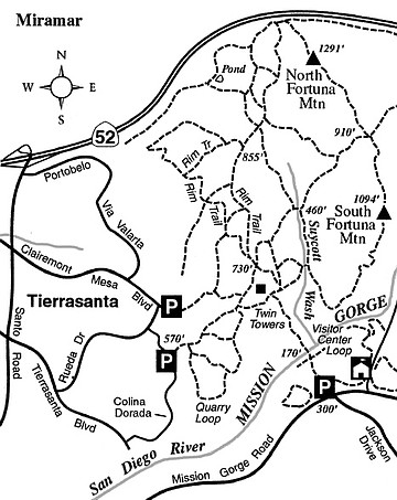
Rim Trail
On foot or by mountain bike, travel panoramic trails on the west rim of Mission Trails Regional Park.
Distance from downtown San Diego: 12 miles
Biking length: 4 miles
Difficulty: Moderate
Here's something you might be interested in.
Rim Trail
Rim Trail
Worthwhile primarily for the view, which can be wide-ranging and spectacular on the clearest late fall or winter days, the Rim Trail in Mission Trails Regional Park rambles along a sparsely vegetated ridgeline overlooking much of metropolitan San Diego to the south and west. To the east, Fortuna Mountain rises like a scruffy hog’s back, and below, at its foot, lies the pristine, oak-lined valley of Suycott Wash.
To get to the trailhead, exit Interstate 15 at Tierrasanta Boulevard. Drive two miles east (nearly to Tierrasanta Boulevard’s dead-end), and turn left on Colina Dorada. Drive 1.0 mile north to the intersection of Colina Dorada and Calle de Vida, where parking is available.
From the trailhead, start hiking (or biking) northeast along the wide, nearly flat trail. At 0.5 mile you pass a deep road cut (accompanied by a trail) on the right where a proposed Clairemont Mesa Boulevard extension would have connected with a proposed extension of Jackson Drive. This road connection is not likely to happen at any time soon, if ever.
Continue straight (northeast) along the west side of a hill to a wide intersection of trails on a 730-foot-elevation saddle at 0.8 mile. The “Twin Towers” cylindrical structures on the hill are part of the second San Diego Aqueduct, which supplies water to our region from sources far to the north.
At the 730-foot saddle, veer left on the signed Rim Trail. Some 2.4 miles later you will return to this saddle after looping counterclockwise on a route that is popular with mountain bikers as well as hikers. There are many intersections along the way with directional signs that are easier to spot if you follow the route counterclockwise. Keep in mind that the Rim Trail is just that — it stays high on the ridges and does not descend very far into ravines. When you get back to the 730-foot saddle, return to the trailhead the way you came.
Rim Trail
On foot or by mountain bike, travel panoramic trails on the west rim of Mission Trails Regional Park.
Distance from downtown San Diego: 12 miles
Biking length: 4 miles
Difficulty: Moderate