Here's something you might be interested in.
Ask a Hipster — Advice you didn't know you needed
Big Screen — Movie commentary
Blurt — Music's inside track
Booze News — San Diego spirits
Classical Music — Immortal beauty
Classifieds — Free and easy
Cover Stories — Front-page features
Drinks All Around — Bartenders' drink recipes
Excerpts — Literary and spiritual excerpts
Feast! — Food & drink reviews
Feature Stories — Local news & stories
Fishing Report — What’s getting hooked from ship and shore
From the Archives — Spotlight on the past
Golden Dreams — Talk of the town
The Gonzo Report — Making the musical scene, or at least reporting from it
Letters — Our inbox
Movies@Home — Local movie buffs share favorites
Movie Reviews — Our critics' picks and pans
Musician Interviews — Up close with local artists
Neighborhood News from Stringers — Hyperlocal news
News Ticker — News & politics
Obermeyer — San Diego politics illustrated
Outdoors — Weekly changes in flora and fauna
Overheard in San Diego — Eavesdropping illustrated
Poetry — The old and the new
Reader Travel — Travel section built by travelers
Reading — The hunt for intellectuals
Roam-O-Rama — SoCal's best hiking/biking trails
San Diego Beer — Inside San Diego suds
SD on the QT — Almost factual news
Sheep and Goats — Places of worship
Special Issues — The best of
Street Style — San Diego streets have style
Surf Diego — Real stories from those braving the waves
Theater — On stage in San Diego this week
Tin Fork — Silver spoon alternative
Under the Radar — Matt Potter's undercover work
Unforgettable — Long-ago San Diego
Unreal Estate — San Diego's priciest pads
Your Week — Daily event picks
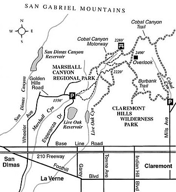
Marshall Canyon
The multiuse trails of Marshall Canyon Regional Park (for hikers, mountain bikers, and equestrians) thread through Marshall and Live Oak canyons in the foothills of the San Gabriel Mountains. The inner recesses of both canyons are smothered by a leafy canopy of live oak, sycamore, and alder trees. In some areas luminescent curtains of poison oak and wild grape cling to the trees, while carpets of blackberry vines and vinca (an ornamental ground cover gone wild) coat the stream banks. Steep, chaparral-covered slopes, dotted here and there with planted pines and eucalyptus, round out the scene.
On the intricate, figure-eight route described here you’ll explore parts of both canyons and pay a visit to a shady picnic spot. Many shorter routes are possible, as well as a longer extension, which could take you farther east into the recently opened, adjoining Claremont Hills Regional Park.
Begin at the equestrian parking area on Golden Hills Road, one mile east of Wheeler Avenue in La Verne. (You can also get there by driving north on Esperanza Drive from Base Line Road.) After only a few steps, you’re enveloped in a shade-dappled milieu — Marshall Canyon. Bear left at the first split at 0.1 mile. You’ll return to this point later on the fork to the right.
In a little while, you leave Marshall Canyon’s shady creek bed and climb to the perimeter of a fenced nursery (0.7 mile) atop the low ridge that divides Marshall and Live Oak canyons. You contour into the latter, where you hook up with a trail coming up along its bottom. Continue upstream to another trail junction (1.2 miles). Stay right and go another 0.1 mile to yet another junction. Take the equestrian trail on the left, ignoring the dirt road that curves right up the hillside. After gaining a sweaty 400 vertical feet on switchbacks you reach a dirt road atop a ridge-running firebreak (1.7 miles, 2220 feet elevation) offering rare, clear-day vistas extending all the way to downtown L.A.’s skyscrapers.
Turn left, continue on the firebreak 0.2 mile, and then veer sharply left on a trail that takes you back down into the shady depths of Live Oak Canyon (2.2 miles). Swing right at the bottom (remaining on the trail) and continue uphill 0.4 mile to a dirt road. Turn left and follow the road 200 yards down to the picnic area (2.8 miles), which sits in a shady draw at the head of Live Oak Canyon.
From the picnic area, keep descending along the dirt road, which at this point follows Live Oak Canyon’s mostly sun-exposed northside slope. About .25 mile below, don’t miss the pleasant trail that conveniently shortcuts a couple of curves in the road. On the road again you pass above the point where you turned uphill a mile earlier. Farther ahead, at 3.7 miles, you leave the road and veer left on a path going down a shallow draw. This soon hooks up with the trail through Live Oak Canyon. Retrace your earlier steps for 0.2 mile, then fork left, remaining in Live Oak Canyon. A murmuring stream swishes through here most of the year. At 4.5 miles, the trail abruptly switches back and climbs to an open flat with two large water tanks. Pass to the left of the first, to the right of the second, and pick up the path that descends into Marshall Canyon. You arrive back at the first split you encountered, and just beyond, your starting point.
This article contains information about a publicly owned recreation or wilderness area. Trails and pathways are not necessarily marked. Conditions can change rapidly. Hikers should be properly equipped and have safety and navigational skills. The Reader and Jerry Schad assume no responsibility for any adverse experience.
Marshall Canyon Regional Park
Explore two deeply shaded canyons in the foothills above Claremont and Pomona.
Distance from downtown San Diego: 120 miles
Hiking or biking length: Up to 5 miles
Difficulty: Moderate to moderately strenuous
Here's something you might be interested in.
Marshall Canyon
Marshall Canyon
The multiuse trails of Marshall Canyon Regional Park (for hikers, mountain bikers, and equestrians) thread through Marshall and Live Oak canyons in the foothills of the San Gabriel Mountains. The inner recesses of both canyons are smothered by a leafy canopy of live oak, sycamore, and alder trees. In some areas luminescent curtains of poison oak and wild grape cling to the trees, while carpets of blackberry vines and vinca (an ornamental ground cover gone wild) coat the stream banks. Steep, chaparral-covered slopes, dotted here and there with planted pines and eucalyptus, round out the scene.
On the intricate, figure-eight route described here you’ll explore parts of both canyons and pay a visit to a shady picnic spot. Many shorter routes are possible, as well as a longer extension, which could take you farther east into the recently opened, adjoining Claremont Hills Regional Park.
Begin at the equestrian parking area on Golden Hills Road, one mile east of Wheeler Avenue in La Verne. (You can also get there by driving north on Esperanza Drive from Base Line Road.) After only a few steps, you’re enveloped in a shade-dappled milieu — Marshall Canyon. Bear left at the first split at 0.1 mile. You’ll return to this point later on the fork to the right.
In a little while, you leave Marshall Canyon’s shady creek bed and climb to the perimeter of a fenced nursery (0.7 mile) atop the low ridge that divides Marshall and Live Oak canyons. You contour into the latter, where you hook up with a trail coming up along its bottom. Continue upstream to another trail junction (1.2 miles). Stay right and go another 0.1 mile to yet another junction. Take the equestrian trail on the left, ignoring the dirt road that curves right up the hillside. After gaining a sweaty 400 vertical feet on switchbacks you reach a dirt road atop a ridge-running firebreak (1.7 miles, 2220 feet elevation) offering rare, clear-day vistas extending all the way to downtown L.A.’s skyscrapers.
Turn left, continue on the firebreak 0.2 mile, and then veer sharply left on a trail that takes you back down into the shady depths of Live Oak Canyon (2.2 miles). Swing right at the bottom (remaining on the trail) and continue uphill 0.4 mile to a dirt road. Turn left and follow the road 200 yards down to the picnic area (2.8 miles), which sits in a shady draw at the head of Live Oak Canyon.
From the picnic area, keep descending along the dirt road, which at this point follows Live Oak Canyon’s mostly sun-exposed northside slope. About .25 mile below, don’t miss the pleasant trail that conveniently shortcuts a couple of curves in the road. On the road again you pass above the point where you turned uphill a mile earlier. Farther ahead, at 3.7 miles, you leave the road and veer left on a path going down a shallow draw. This soon hooks up with the trail through Live Oak Canyon. Retrace your earlier steps for 0.2 mile, then fork left, remaining in Live Oak Canyon. A murmuring stream swishes through here most of the year. At 4.5 miles, the trail abruptly switches back and climbs to an open flat with two large water tanks. Pass to the left of the first, to the right of the second, and pick up the path that descends into Marshall Canyon. You arrive back at the first split you encountered, and just beyond, your starting point.
This article contains information about a publicly owned recreation or wilderness area. Trails and pathways are not necessarily marked. Conditions can change rapidly. Hikers should be properly equipped and have safety and navigational skills. The Reader and Jerry Schad assume no responsibility for any adverse experience.
Marshall Canyon Regional Park
Explore two deeply shaded canyons in the foothills above Claremont and Pomona.
Distance from downtown San Diego: 120 miles
Hiking or biking length: Up to 5 miles
Difficulty: Moderate to moderately strenuous