Here's something you might be interested in.
Ask a Hipster — Advice you didn't know you needed
Big Screen — Movie commentary
Blurt — Music's inside track
Booze News — San Diego spirits
Classical Music — Immortal beauty
Classifieds — Free and easy
Cover Stories — Front-page features
Drinks All Around — Bartenders' drink recipes
Excerpts — Literary and spiritual excerpts
Feast! — Food & drink reviews
Feature Stories — Local news & stories
Fishing Report — What’s getting hooked from ship and shore
From the Archives — Spotlight on the past
Golden Dreams — Talk of the town
The Gonzo Report — Making the musical scene, or at least reporting from it
Letters — Our inbox
Movies@Home — Local movie buffs share favorites
Movie Reviews — Our critics' picks and pans
Musician Interviews — Up close with local artists
Neighborhood News from Stringers — Hyperlocal news
News Ticker — News & politics
Obermeyer — San Diego politics illustrated
Outdoors — Weekly changes in flora and fauna
Overheard in San Diego — Eavesdropping illustrated
Poetry — The old and the new
Reader Travel — Travel section built by travelers
Reading — The hunt for intellectuals
Roam-O-Rama — SoCal's best hiking/biking trails
San Diego Beer — Inside San Diego suds
SD on the QT — Almost factual news
Sheep and Goats — Places of worship
Special Issues — The best of
Street Style — San Diego streets have style
Surf Diego — Real stories from those braving the waves
Theater — On stage in San Diego this week
Tin Fork — Silver spoon alternative
Under the Radar — Matt Potter's undercover work
Unforgettable — Long-ago San Diego
Unreal Estate — San Diego's priciest pads
Your Week — Daily event picks
From the top of the Angeles Crest, view an unmatched panorama of ocean, islands, and mountains.
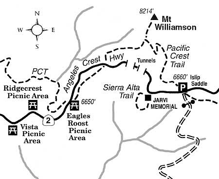
Angeles Crest Highway (Highway 2) snakes along the crest of the San Gabriel Mountains, offering always impressive and sometimes stupendous views of thousands of square miles worth of Southern California real estate, mountain and desert wilderness spaces, and a big slice of the Pacific Ocean. For months now, an upper section of the highway west of Wrightwood and Big Pines has been closed due to storm damage. Currently, however, motorists approaching from the west (La Canada/Pasadena) end of the highway can navigate as far as Islip Saddle, a drive of some 40 miles east from Interstate 210 at La Canada.
Only one mile short of the road closure at Islip Saddle, and just beyond the second of two highway tunnels, you'll come upon the Jarvi Memorial Vista, which honors Sim Jarvi, a former Angeles National Forest supervisor. This vista point also serves as the trailhead for the Sierra Alta Nature Trail. Due to its short length, the trail isn't much good for significant exercise, but it does feature interpretive plaques highlighting the local flora (ponderosa pines, Jeffrey pines, canyon live oaks, etc.), as well as calling attention to viewful features in various directions.
The trail perches over the upper tributaries of Bear Creek, where (yes) black bears do roam. The exceedingly rugged terrain just below and to the south (classified as the San Gabriel Wilderness) and additional equally rugged spaces to the east (the Sheep Mountain Wilderness) also harbor significant herds of Nelson bighorn sheep.
Clear-day views from the memorial vista and the trail can include the ocean, as well as Santa Catalina and San Clemente islands. The clearest weather of all is likely to take place from November through February. Winter snowfall, however, could result in a seasonal closure of upper Angeles Crest Highway starting in December or January. For the latest on road conditions, it is helpful to call the Caltrans information hotline (800-427-7623), and press "2" for information on Highway 2. Also be aware that during any exploration away from your car, you'll need to display on your vehicle a National Forest Adventure Pass permit, which is widely available for purchase and valid in all four national forests of Southern California.
This article contains information about a publicly owned recreation or wilderness area. Trails and pathways are not necessarily marked. Conditions can change rapidly. Hikers should be properly equipped and have safety and navigational skills. The Reader and Jerry Schad assume no responsibility for any adverse experience.
Here's something you might be interested in.
From the top of the Angeles Crest, view an unmatched panorama of ocean, islands, and mountains.
From the top of the Angeles Crest, view an unmatched panorama of ocean, islands, and mountains.
Angeles Crest Highway (Highway 2) snakes along the crest of the San Gabriel Mountains, offering always impressive and sometimes stupendous views of thousands of square miles worth of Southern California real estate, mountain and desert wilderness spaces, and a big slice of the Pacific Ocean. For months now, an upper section of the highway west of Wrightwood and Big Pines has been closed due to storm damage. Currently, however, motorists approaching from the west (La Canada/Pasadena) end of the highway can navigate as far as Islip Saddle, a drive of some 40 miles east from Interstate 210 at La Canada.
Only one mile short of the road closure at Islip Saddle, and just beyond the second of two highway tunnels, you'll come upon the Jarvi Memorial Vista, which honors Sim Jarvi, a former Angeles National Forest supervisor. This vista point also serves as the trailhead for the Sierra Alta Nature Trail. Due to its short length, the trail isn't much good for significant exercise, but it does feature interpretive plaques highlighting the local flora (ponderosa pines, Jeffrey pines, canyon live oaks, etc.), as well as calling attention to viewful features in various directions.
The trail perches over the upper tributaries of Bear Creek, where (yes) black bears do roam. The exceedingly rugged terrain just below and to the south (classified as the San Gabriel Wilderness) and additional equally rugged spaces to the east (the Sheep Mountain Wilderness) also harbor significant herds of Nelson bighorn sheep.
Clear-day views from the memorial vista and the trail can include the ocean, as well as Santa Catalina and San Clemente islands. The clearest weather of all is likely to take place from November through February. Winter snowfall, however, could result in a seasonal closure of upper Angeles Crest Highway starting in December or January. For the latest on road conditions, it is helpful to call the Caltrans information hotline (800-427-7623), and press "2" for information on Highway 2. Also be aware that during any exploration away from your car, you'll need to display on your vehicle a National Forest Adventure Pass permit, which is widely available for purchase and valid in all four national forests of Southern California.
This article contains information about a publicly owned recreation or wilderness area. Trails and pathways are not necessarily marked. Conditions can change rapidly. Hikers should be properly equipped and have safety and navigational skills. The Reader and Jerry Schad assume no responsibility for any adverse experience.