Here's something you might be interested in.
Ask a Hipster — Advice you didn't know you needed
Big Screen — Movie commentary
Blurt — Music's inside track
Booze News — San Diego spirits
Classical Music — Immortal beauty
Classifieds — Free and easy
Cover Stories — Front-page features
Drinks All Around — Bartenders' drink recipes
Excerpts — Literary and spiritual excerpts
Feast! — Food & drink reviews
Feature Stories — Local news & stories
Fishing Report — What’s getting hooked from ship and shore
From the Archives — Spotlight on the past
Golden Dreams — Talk of the town
The Gonzo Report — Making the musical scene, or at least reporting from it
Letters — Our inbox
Movies@Home — Local movie buffs share favorites
Movie Reviews — Our critics' picks and pans
Musician Interviews — Up close with local artists
Neighborhood News from Stringers — Hyperlocal news
News Ticker — News & politics
Obermeyer — San Diego politics illustrated
Outdoors — Weekly changes in flora and fauna
Overheard in San Diego — Eavesdropping illustrated
Poetry — The old and the new
Reader Travel — Travel section built by travelers
Reading — The hunt for intellectuals
Roam-O-Rama — SoCal's best hiking/biking trails
San Diego Beer — Inside San Diego suds
SD on the QT — Almost factual news
Sheep and Goats — Places of worship
Special Issues — The best of
Street Style — San Diego streets have style
Surf Diego — Real stories from those braving the waves
Theater — On stage in San Diego this week
Tin Fork — Silver spoon alternative
Under the Radar — Matt Potter's undercover work
Unforgettable — Long-ago San Diego
Unreal Estate — San Diego's priciest pads
Your Week — Daily event picks
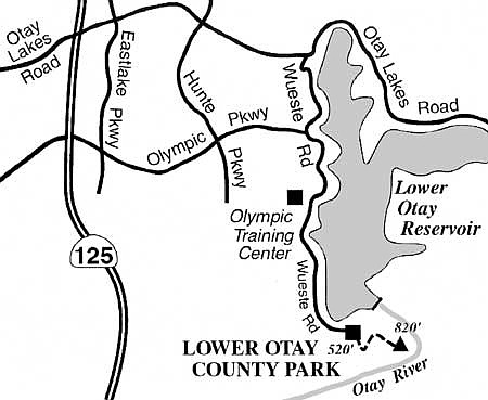
Enjoy a unique South Bay vista in Lower Otay County Park.
Formerly remote Lower Otay County Park, perched on a hillside above the dam of Lower Otay Reservoir, is now only a few minutes' drive from tens of thousands of new South Bay residents in communities such as Eastlake and Otay Ranch. With the imminent opening of the Route 125 toll road through eastern Chula Vista, the park will soon be more quickly accessible to visitors from other parts of San Diego County.
To get to the park from either Interstate 805 or the new Route 125 toll road, exit at Olympic Parkway and drive east until Olympic Parkway ends at Wueste Road. Turn right and continue south to the end of Wueste Road, where you'll find the entrance to Lower Otay County Park. There's a small day-use fee charged for entry. The October 2007 Harris Fire did not affect Lower Otay County Park; however, you may want to check with the county parks department (858-694-3049) to learn of any possible changes in the park's operating schedule.
A recent renovation of the county park grounds has turned it into quite a scenic spot for picnicking, with a view south into Mexico. That view can be greatly improved if you care to climb eastward and 300 vertical feet higher to a more panoramic vantage point.
From the topmost parking lot inside the park, walk past a gate and go uphill on a service road, or else use a zigzagging foot trail that gets you to the same destination: a bench on a knoll overlooking the reservoir. Don't stop there; simply continue on the eroded road or firebreak that keeps going straight up the slope.
You'll end up on a rounded summit high enough for you to see the Pacific Ocean, the terrestrial ocean of rooftops covering eastern Chula Vista, and -- when clear enough -- the upper floors of downtown San Diego's skyscrapers. The most impressive vista, however, is north toward Lower Otay Reservoir, which spreads its waters far and wide, seemingly at your feet. To the east, the long ridge of Otay Mountain climbs steadily toward the mountain range's 3572-foot high point. This upward pitch, however, is interrupted by the Otay River gorge immediately below you, so the rounded summit you are standing on is as far as you can get on an easy hike. The Harris-Fire-blackened swath of landscape you will see in the distance, beyond the lake, promises to turn emerald green if and when soaking rains arrive this winter.
This article contains information about a publicly owned recreation or wilderness area. Trails and pathways are not necessarily marked. Conditions can change rapidly. Hikers should be properly equipped and have safety and navigational skills. The Reader and Jerry Schad assume no responsibility for any adverse experience.
Here's something you might be interested in.
Enjoy a unique South Bay vista in Lower Otay County Park.
Enjoy a unique South Bay vista in Lower Otay County Park.
Formerly remote Lower Otay County Park, perched on a hillside above the dam of Lower Otay Reservoir, is now only a few minutes' drive from tens of thousands of new South Bay residents in communities such as Eastlake and Otay Ranch. With the imminent opening of the Route 125 toll road through eastern Chula Vista, the park will soon be more quickly accessible to visitors from other parts of San Diego County.
To get to the park from either Interstate 805 or the new Route 125 toll road, exit at Olympic Parkway and drive east until Olympic Parkway ends at Wueste Road. Turn right and continue south to the end of Wueste Road, where you'll find the entrance to Lower Otay County Park. There's a small day-use fee charged for entry. The October 2007 Harris Fire did not affect Lower Otay County Park; however, you may want to check with the county parks department (858-694-3049) to learn of any possible changes in the park's operating schedule.
A recent renovation of the county park grounds has turned it into quite a scenic spot for picnicking, with a view south into Mexico. That view can be greatly improved if you care to climb eastward and 300 vertical feet higher to a more panoramic vantage point.
From the topmost parking lot inside the park, walk past a gate and go uphill on a service road, or else use a zigzagging foot trail that gets you to the same destination: a bench on a knoll overlooking the reservoir. Don't stop there; simply continue on the eroded road or firebreak that keeps going straight up the slope.
You'll end up on a rounded summit high enough for you to see the Pacific Ocean, the terrestrial ocean of rooftops covering eastern Chula Vista, and -- when clear enough -- the upper floors of downtown San Diego's skyscrapers. The most impressive vista, however, is north toward Lower Otay Reservoir, which spreads its waters far and wide, seemingly at your feet. To the east, the long ridge of Otay Mountain climbs steadily toward the mountain range's 3572-foot high point. This upward pitch, however, is interrupted by the Otay River gorge immediately below you, so the rounded summit you are standing on is as far as you can get on an easy hike. The Harris-Fire-blackened swath of landscape you will see in the distance, beyond the lake, promises to turn emerald green if and when soaking rains arrive this winter.
This article contains information about a publicly owned recreation or wilderness area. Trails and pathways are not necessarily marked. Conditions can change rapidly. Hikers should be properly equipped and have safety and navigational skills. The Reader and Jerry Schad assume no responsibility for any adverse experience.