Here's something you might be interested in.
Ask a Hipster — Advice you didn't know you needed
Big Screen — Movie commentary
Blurt — Music's inside track
Booze News — San Diego spirits
Classical Music — Immortal beauty
Classifieds — Free and easy
Cover Stories — Front-page features
Drinks All Around — Bartenders' drink recipes
Excerpts — Literary and spiritual excerpts
Feast! — Food & drink reviews
Feature Stories — Local news & stories
Fishing Report — What’s getting hooked from ship and shore
From the Archives — Spotlight on the past
Golden Dreams — Talk of the town
The Gonzo Report — Making the musical scene, or at least reporting from it
Letters — Our inbox
Movies@Home — Local movie buffs share favorites
Movie Reviews — Our critics' picks and pans
Musician Interviews — Up close with local artists
Neighborhood News from Stringers — Hyperlocal news
News Ticker — News & politics
Obermeyer — San Diego politics illustrated
Outdoors — Weekly changes in flora and fauna
Overheard in San Diego — Eavesdropping illustrated
Poetry — The old and the new
Reader Travel — Travel section built by travelers
Reading — The hunt for intellectuals
Roam-O-Rama — SoCal's best hiking/biking trails
San Diego Beer — Inside San Diego suds
SD on the QT — Almost factual news
Sheep and Goats — Places of worship
Special Issues — The best of
Street Style — San Diego streets have style
Surf Diego — Real stories from those braving the waves
Theater — On stage in San Diego this week
Tin Fork — Silver spoon alternative
Under the Radar — Matt Potter's undercover work
Unforgettable — Long-ago San Diego
Unreal Estate — San Diego's priciest pads
Your Week — Daily event picks
Practice navigational skills on a one-way, mostly downhill trek using the Tenaja Falls Trail near Temecula
The Tenaja Falls hiking or backpacking traverse takes you one way through Cleveland National Forest's San Mateo Canyon Wilderness -- Southern California's only large coastal wilderness area. You can see plenty of winter and early spring scenery (it may be too hot and dry there May through November) without repeating any footsteps.
You could have someone drop you off at the start and later pick you up (four or more hours later) at the finish. Or, with just one car, you might think of a way to use a bicycle (to be left at the start or end point) to turn this trek into a hybrid hike/bike loop. Bikes are not allowed on the hiking route itself, but they are well suited to traveling the 14 miles of mostly narrow, thinly paved Wildomar Road connecting the start and finish points of the hike. A wilderness permit is not required for day use of the Tenaja Fall Trail, but it is required for overnight backpacking. Cleveland National Forest's Corona ranger's office, 951-736-1811, has details.
You'll want to start hiking at the Morgan Trailhead on Killen Trail (a.k.a. South Main Divide Road, later becoming Wildomar Road), 2.7 miles south of Ortega Highway (Highway 74). You'll end the hike at the Tenaja Falls Trailhead, 14 miles south from the Morgan Trailhead via Wildomar Road. The Tenaja Falls Trailhead can also be reached by way of Clinton Keith and Tenaja roads, west of Temecula. Logistical planning is definitely helped by obtaining an Auto Club map of the area (Riverside County or Los Angeles/Orange Counties and Vicinity), and by obtaining a San Mateo Canyon Wilderness topographic map published by Cleveland National Forest. Also, be aware that cars parked at either trailhead must have a National Forest Adventure Pass posted.
From the Morgan Trailhead you begin with a descent through chaparral on the Morgan Trail. Soon, you enter the boundary of San Mateo Canyon Wilderness and plunge into the dark, upper reaches of Morrell Canyon. The canyon is loaded with magnificent live oaks, the hardy survivors of periodic wildfires. The trail crosses Morrell Canyon's small creek at 1.0 mile, then rises back into the sunny chaparral.
At 2.2 miles, Tenaja Falls Trail branches left. Heading east, you cross a wooded ravine and steadily and crookedly rise on rocky, chaparral-clad slopes. Later you turn south on those slopes, still climbing, and skirt the boundary of a parcel of private land lying within both the national forest and the wilderness area. Most of this private "inholding" covers the flat, grassy valley named Potero de la Cienega.
Climbing ends at a high point just above the 2800-foot elevation contour, some 400 feet above the flat floor of the valley. You then descend south into the southeastern corner of the valley. At 4.3 miles you join a disused dirt road, which continues going south around the valley's east edge.
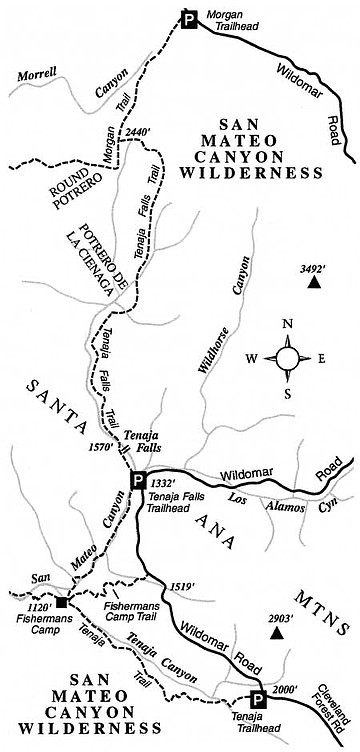
The old road finally curls west around the inholding and then, starting at 5.5 miles, assumes a descending course south down the left side of V-shaped upper San Mateo Canyon. You can often hear water cascading down the canyon bottom, which is virtually impossible to reach due to dense chaparral growth.
By 7.0 miles you're right alongside the canyon bottom, and you benefit from the soothing sound of rushing water and the sheltering shade of streamside oaks. At 7.5 miles you cross San Mateo Canyon's creek on an old concrete ford just above Tenaja Falls, switching over to the canyon's west side. After rapidly descending, there's only one more creek crossing to contend with at the very end, then you arrive at the Tenaja Falls Trailhead.
This article contains information about a publicly owned recreation or wilderness area. Trails and pathways are not necessarily marked. Conditions can change rapidly. Hikers should be properly equipped and have safety and navigational skills. The Reader and Jerry Schad assume no responsibility for any adverse experience.
Here's something you might be interested in.
Practice navigational skills on a one-way, mostly downhill trek using the Tenaja Falls Trail near Temecula
Practice navigational skills on a one-way, mostly downhill trek using the Tenaja Falls Trail near Temecula
The Tenaja Falls hiking or backpacking traverse takes you one way through Cleveland National Forest's San Mateo Canyon Wilderness -- Southern California's only large coastal wilderness area. You can see plenty of winter and early spring scenery (it may be too hot and dry there May through November) without repeating any footsteps.
You could have someone drop you off at the start and later pick you up (four or more hours later) at the finish. Or, with just one car, you might think of a way to use a bicycle (to be left at the start or end point) to turn this trek into a hybrid hike/bike loop. Bikes are not allowed on the hiking route itself, but they are well suited to traveling the 14 miles of mostly narrow, thinly paved Wildomar Road connecting the start and finish points of the hike. A wilderness permit is not required for day use of the Tenaja Fall Trail, but it is required for overnight backpacking. Cleveland National Forest's Corona ranger's office, 951-736-1811, has details.
You'll want to start hiking at the Morgan Trailhead on Killen Trail (a.k.a. South Main Divide Road, later becoming Wildomar Road), 2.7 miles south of Ortega Highway (Highway 74). You'll end the hike at the Tenaja Falls Trailhead, 14 miles south from the Morgan Trailhead via Wildomar Road. The Tenaja Falls Trailhead can also be reached by way of Clinton Keith and Tenaja roads, west of Temecula. Logistical planning is definitely helped by obtaining an Auto Club map of the area (Riverside County or Los Angeles/Orange Counties and Vicinity), and by obtaining a San Mateo Canyon Wilderness topographic map published by Cleveland National Forest. Also, be aware that cars parked at either trailhead must have a National Forest Adventure Pass posted.
From the Morgan Trailhead you begin with a descent through chaparral on the Morgan Trail. Soon, you enter the boundary of San Mateo Canyon Wilderness and plunge into the dark, upper reaches of Morrell Canyon. The canyon is loaded with magnificent live oaks, the hardy survivors of periodic wildfires. The trail crosses Morrell Canyon's small creek at 1.0 mile, then rises back into the sunny chaparral.
At 2.2 miles, Tenaja Falls Trail branches left. Heading east, you cross a wooded ravine and steadily and crookedly rise on rocky, chaparral-clad slopes. Later you turn south on those slopes, still climbing, and skirt the boundary of a parcel of private land lying within both the national forest and the wilderness area. Most of this private "inholding" covers the flat, grassy valley named Potero de la Cienega.
Climbing ends at a high point just above the 2800-foot elevation contour, some 400 feet above the flat floor of the valley. You then descend south into the southeastern corner of the valley. At 4.3 miles you join a disused dirt road, which continues going south around the valley's east edge.
The old road finally curls west around the inholding and then, starting at 5.5 miles, assumes a descending course south down the left side of V-shaped upper San Mateo Canyon. You can often hear water cascading down the canyon bottom, which is virtually impossible to reach due to dense chaparral growth.
By 7.0 miles you're right alongside the canyon bottom, and you benefit from the soothing sound of rushing water and the sheltering shade of streamside oaks. At 7.5 miles you cross San Mateo Canyon's creek on an old concrete ford just above Tenaja Falls, switching over to the canyon's west side. After rapidly descending, there's only one more creek crossing to contend with at the very end, then you arrive at the Tenaja Falls Trailhead.
This article contains information about a publicly owned recreation or wilderness area. Trails and pathways are not necessarily marked. Conditions can change rapidly. Hikers should be properly equipped and have safety and navigational skills. The Reader and Jerry Schad assume no responsibility for any adverse experience.
Comments