Sponsored
Sponsored
Tens of millions of years in the making, Devil's Punchbowl is without a doubt Los Angeles County's most spectacular geological showplace. Looking into this chasm, you immediately sense the enormity of the forces that produced the tilted and tangled collection of beige sandstone slabs.
The Punchbowl is caught between two active faults -- the main San Andreas Fault and an offshoot, the Punchbowl Fault -- along which old sedimentary formations have been pushed upward and crumpled downward as well as transported horizontally. Erosion has put the final touches on the scene, roughing out the bowl-shaped gorge of Punchbowl Canyon and carving, in a host of unique ways, the rocks exposed at the surface.
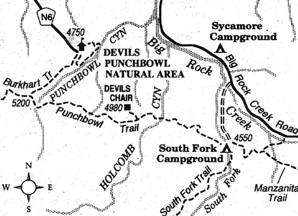
The 1300-acre Devil's Punchbowl Natural Area, operated by Los Angeles County, lies within Angeles National Forest and borders the "high" or western section of the Mojave Desert. Here you'll find a superb nature center, a couple of short nature walks (including the loop trail described here), and the Punchbowl Trail -- a part of the High Desert National Recreation Trail that goes across the north slope of the San Gabriel Mountains.
Devil's Punchbowl is open seven days a week from sunrise to sunset, with no admission charge. To get there via L.A. and the San Fernando Valley, take Interstate 5 north and Antelope Valley Freeway (Highway 14) east. Exit Highway 14 at Pearblossom Highway (Highway 138), and follow it east through the town of Littlerock to Pearblossom. At Pearblossom, turn right on Longview Road (County N6) and follow signs for the park, seven miles ahead. (As an alternate route of equal distance and probably equal time, San Diegans can follow Interstate 15 north past San Bernardino, and then use Highway 138 to travel west to Pearblossom.)
The one-mile long Devil's Punchbowl loop trail is a perfect introduction to the Punchbowl area. It begins just behind the nature center, zigzags down off the rim to touch the seasonal creek in Punchbowl Canyon, and then climbs back out of the canyon opposite some of the tallest upright formations in the park. Near the start of the trail is a side path -- the 0.3-mile Pinon Pathway -- a self-guiding nature trail that loops through the pinyon-juniper forest along the Punchbowl rim.
During late fall and winter, snow may dust the 4000-foot elevation of the Punchbowl itself and leave a longer-lived mantle of white on the pine-dotted slopes of the San Gabriel Mountains just above. During these episodes the loop trail can become muddy and slippery, and therefore possibly not suitable for small children.