Here's something you might be interested in.
Ask a Hipster — Advice you didn't know you needed
Big Screen — Movie commentary
Blurt — Music's inside track
Booze News — San Diego spirits
Classical Music — Immortal beauty
Classifieds — Free and easy
Cover Stories — Front-page features
Drinks All Around — Bartenders' drink recipes
Excerpts — Literary and spiritual excerpts
Feast! — Food & drink reviews
Feature Stories — Local news & stories
Fishing Report — What’s getting hooked from ship and shore
From the Archives — Spotlight on the past
Golden Dreams — Talk of the town
The Gonzo Report — Making the musical scene, or at least reporting from it
Letters — Our inbox
Movies@Home — Local movie buffs share favorites
Movie Reviews — Our critics' picks and pans
Musician Interviews — Up close with local artists
Neighborhood News from Stringers — Hyperlocal news
News Ticker — News & politics
Obermeyer — San Diego politics illustrated
Outdoors — Weekly changes in flora and fauna
Overheard in San Diego — Eavesdropping illustrated
Poetry — The old and the new
Reader Travel — Travel section built by travelers
Reading — The hunt for intellectuals
Roam-O-Rama — SoCal's best hiking/biking trails
San Diego Beer — Inside San Diego suds
SD on the QT — Almost factual news
Sheep and Goats — Places of worship
Special Issues — The best of
Street Style — San Diego streets have style
Surf Diego — Real stories from those braving the waves
Theater — On stage in San Diego this week
Tin Fork — Silver spoon alternative
Under the Radar — Matt Potter's undercover work
Unforgettable — Long-ago San Diego
Unreal Estate — San Diego's priciest pads
Your Week — Daily event picks
Walk on the wild side of L.A. by climbing to mile-high elevation in the City of Los Angeles.
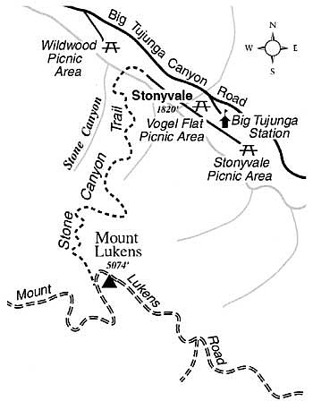
From the top of Mount Lukens, the high point in elevation within the city limit of Los Angeles, you can peer over a vast and spacious urban plain -- coastal haze and smog permitting. During the next five months temperatures should be mercifully cool for the strenuous climb to the top. Late fall and winter brings clearer, cleaner, and drier air -- which will benefit your lungs as well as the long views you'll get on top.
From the foothill community of Sunland, off Interstate 210, take either Oro Vista Avenue or Mt. Gleason Avenue north to Big Tujunga Canyon Road. Turn right and drive east into the canyon. Some seven miles up the canyon, look for the well-marked turnoff for Vogel Flat. Turn right, drive to the bottom of the hill, and park at Vogel Flat Picnic Area, open from 8 a.m. to 6 p.m. A short way east is Stonyvale Picnic Area, open 6 a.m. to 10 p.m. -- useful if you arrive early or will be returning late. A National Forest Adventure Pass is needed for parking.
On foot, head west down a narrow, paved road (private, but with public easement) through the cabin community of Stonyvale. When the pavement ends after 0.7 mile, continue on dirt for another one-quarter mile or so. Choose a place to ford Big Tujunga creek, step or wade across, and find the Stone Canyon Trail on the far bank. From afar you can spot this trail going straight up the sloping terrace just left (east) of Stone Canyon's wide, boulder-filled mouth. Once you're on that terrace, settle into a pace that will allow you to persevere over the next three miles and 3200 feet of vertical ascent.
From the vantage point of the first switchback, you can look down on the thousands of storm-tossed granitic boulders filling Stone Canyon from wall to wall. Although Stone Canyon's boulders are frozen in place, you can almost sense their movement over geologic time. Even today floods continue to reshape this canyon and many other steep canyons in the San Gabriel Mountains.
Ahead, there are many twists and turns along precipitous slopes covered by chaparral. The dizzying view from the midpoint of the trail encompasses a long, obviously linear stretch of Big Tujunga Canyon. This segment of the canyon is traced by the San Gabriel Fault and its offshoot, the Sierra Madre Fault.
You'll eventually come to a steep, bulldozed track leading to the bald summit ridge of Mount Lukens. Go 0.5 mile farther to the highest point on the ridge, the peak itself, which is occupied by several antenna structures. The view, north and east across the various ridges and peaks of the San Gabriels, and south and west across the endlessly spreading city, can be fabulous -- but only on a clear day.
Here's something you might be interested in.
Walk on the wild side of L.A. by climbing to mile-high elevation in the City of Los Angeles.
Walk on the wild side of L.A. by climbing to mile-high elevation in the City of Los Angeles.
From the top of Mount Lukens, the high point in elevation within the city limit of Los Angeles, you can peer over a vast and spacious urban plain -- coastal haze and smog permitting. During the next five months temperatures should be mercifully cool for the strenuous climb to the top. Late fall and winter brings clearer, cleaner, and drier air -- which will benefit your lungs as well as the long views you'll get on top.
From the foothill community of Sunland, off Interstate 210, take either Oro Vista Avenue or Mt. Gleason Avenue north to Big Tujunga Canyon Road. Turn right and drive east into the canyon. Some seven miles up the canyon, look for the well-marked turnoff for Vogel Flat. Turn right, drive to the bottom of the hill, and park at Vogel Flat Picnic Area, open from 8 a.m. to 6 p.m. A short way east is Stonyvale Picnic Area, open 6 a.m. to 10 p.m. -- useful if you arrive early or will be returning late. A National Forest Adventure Pass is needed for parking.
On foot, head west down a narrow, paved road (private, but with public easement) through the cabin community of Stonyvale. When the pavement ends after 0.7 mile, continue on dirt for another one-quarter mile or so. Choose a place to ford Big Tujunga creek, step or wade across, and find the Stone Canyon Trail on the far bank. From afar you can spot this trail going straight up the sloping terrace just left (east) of Stone Canyon's wide, boulder-filled mouth. Once you're on that terrace, settle into a pace that will allow you to persevere over the next three miles and 3200 feet of vertical ascent.
From the vantage point of the first switchback, you can look down on the thousands of storm-tossed granitic boulders filling Stone Canyon from wall to wall. Although Stone Canyon's boulders are frozen in place, you can almost sense their movement over geologic time. Even today floods continue to reshape this canyon and many other steep canyons in the San Gabriel Mountains.
Ahead, there are many twists and turns along precipitous slopes covered by chaparral. The dizzying view from the midpoint of the trail encompasses a long, obviously linear stretch of Big Tujunga Canyon. This segment of the canyon is traced by the San Gabriel Fault and its offshoot, the Sierra Madre Fault.
You'll eventually come to a steep, bulldozed track leading to the bald summit ridge of Mount Lukens. Go 0.5 mile farther to the highest point on the ridge, the peak itself, which is occupied by several antenna structures. The view, north and east across the various ridges and peaks of the San Gabriels, and south and west across the endlessly spreading city, can be fabulous -- but only on a clear day.