Here's something you might be interested in.
Ask a Hipster — Advice you didn't know you needed
Big Screen — Movie commentary
Blurt — Music's inside track
Booze News — San Diego spirits
Classical Music — Immortal beauty
Classifieds — Free and easy
Cover Stories — Front-page features
Drinks All Around — Bartenders' drink recipes
Excerpts — Literary and spiritual excerpts
Feast! — Food & drink reviews
Feature Stories — Local news & stories
Fishing Report — What’s getting hooked from ship and shore
From the Archives — Spotlight on the past
Golden Dreams — Talk of the town
The Gonzo Report — Making the musical scene, or at least reporting from it
Letters — Our inbox
Movies@Home — Local movie buffs share favorites
Movie Reviews — Our critics' picks and pans
Musician Interviews — Up close with local artists
Neighborhood News from Stringers — Hyperlocal news
News Ticker — News & politics
Obermeyer — San Diego politics illustrated
Outdoors — Weekly changes in flora and fauna
Overheard in San Diego — Eavesdropping illustrated
Poetry — The old and the new
Reader Travel — Travel section built by travelers
Reading — The hunt for intellectuals
Roam-O-Rama — SoCal's best hiking/biking trails
San Diego Beer — Inside San Diego suds
SD on the QT — Almost factual news
Sheep and Goats — Places of worship
Special Issues — The best of
Street Style — San Diego streets have style
Surf Diego — Real stories from those braving the waves
Theater — On stage in San Diego this week
Tin Fork — Silver spoon alternative
Under the Radar — Matt Potter's undercover work
Unforgettable — Long-ago San Diego
Unreal Estate — San Diego's priciest pads
Your Week — Daily event picks
Explore Weir Canyon Park, an open space preserve bordering Anaheim Hills.
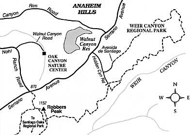
Weir Canyon Regional Park forms a belt of open space along the south edge of Anaheim -- not the familiar Disneyland/convention center/stadium part of that city, but the Anaheim Hills section, where new and newer suburban homes climb the rounded foothills of the Santa Ana Mountains. The park is contiguous with many thousands of acres of Irvine Company land that has recently been acquired for habitat preservation by Orange County. Presently much of that land is under the interim management of the Nature Conservancy. Weir Canyon park itself is open to passive recreation, primarily by hikers and mountain bikers. They can explore rolling hills draped in sage-scrub and chaparral vegetation, badlands-style cliffs, cavernous sandstone outcrops, and oak-lined ravines.
Three principal entry points serve Weir Canyon park: Serrano Avenue at Nohl Ranch Road, the dead-end of Hidden Canyon Road, and the dead-end of Avenida de Santiago. From the first entry point, a gravel service road just east of an elementary school ascends toward a rocky promontory called Robbers Peak. Its name commemorates the notorious outlaws Joaquin Murietta, Three Finger Jack, and others of the late 1800s. Sweeping down out of the hills, these bandits terrorized the farmers below and preyed upon passengers traveling the Butterfield Stage. From Robbers Peak they could easily spot and evade sheriff's posses by slipping into the rugged ravines and canyons (including Weir Canyon) leading back toward the Santa Ana Mountains. From Robbers Peak, you get an impressive view of the lowlands to the south and west -- a composite of pastoral landscape and spreading suburban sprawl. On the clearest days, the panorama includes the blue arc of the Pacific Ocean and Santa Catalina Island.
From Robbers Peak two distinct trails descend southwest toward Santiago Oaks Regional Park. A trail going northeast connects to Hidden Canyon Road. A longer looping route of about 3.5 miles traverses the hillsides and north rim of Weir Canyon and ends at the east end of Avenida de Santiago.
The bottom of Weir Canyon itself, managed by the Nature Conservancy, may soon be open to visitation by guided tour only.
Here's something you might be interested in.
Explore Weir Canyon Park, an open space preserve bordering Anaheim Hills.
Explore Weir Canyon Park, an open space preserve bordering Anaheim Hills.
Weir Canyon Regional Park forms a belt of open space along the south edge of Anaheim -- not the familiar Disneyland/convention center/stadium part of that city, but the Anaheim Hills section, where new and newer suburban homes climb the rounded foothills of the Santa Ana Mountains. The park is contiguous with many thousands of acres of Irvine Company land that has recently been acquired for habitat preservation by Orange County. Presently much of that land is under the interim management of the Nature Conservancy. Weir Canyon park itself is open to passive recreation, primarily by hikers and mountain bikers. They can explore rolling hills draped in sage-scrub and chaparral vegetation, badlands-style cliffs, cavernous sandstone outcrops, and oak-lined ravines.
Three principal entry points serve Weir Canyon park: Serrano Avenue at Nohl Ranch Road, the dead-end of Hidden Canyon Road, and the dead-end of Avenida de Santiago. From the first entry point, a gravel service road just east of an elementary school ascends toward a rocky promontory called Robbers Peak. Its name commemorates the notorious outlaws Joaquin Murietta, Three Finger Jack, and others of the late 1800s. Sweeping down out of the hills, these bandits terrorized the farmers below and preyed upon passengers traveling the Butterfield Stage. From Robbers Peak they could easily spot and evade sheriff's posses by slipping into the rugged ravines and canyons (including Weir Canyon) leading back toward the Santa Ana Mountains. From Robbers Peak, you get an impressive view of the lowlands to the south and west -- a composite of pastoral landscape and spreading suburban sprawl. On the clearest days, the panorama includes the blue arc of the Pacific Ocean and Santa Catalina Island.
From Robbers Peak two distinct trails descend southwest toward Santiago Oaks Regional Park. A trail going northeast connects to Hidden Canyon Road. A longer looping route of about 3.5 miles traverses the hillsides and north rim of Weir Canyon and ends at the east end of Avenida de Santiago.
The bottom of Weir Canyon itself, managed by the Nature Conservancy, may soon be open to visitation by guided tour only.