Here's something you might be interested in.
Ask a Hipster — Advice you didn't know you needed
Big Screen — Movie commentary
Blurt — Music's inside track
Booze News — San Diego spirits
Classical Music — Immortal beauty
Classifieds — Free and easy
Cover Stories — Front-page features
Drinks All Around — Bartenders' drink recipes
Excerpts — Literary and spiritual excerpts
Feast! — Food & drink reviews
Feature Stories — Local news & stories
Fishing Report — What’s getting hooked from ship and shore
From the Archives — Spotlight on the past
Golden Dreams — Talk of the town
The Gonzo Report — Making the musical scene, or at least reporting from it
Letters — Our inbox
Movies@Home — Local movie buffs share favorites
Movie Reviews — Our critics' picks and pans
Musician Interviews — Up close with local artists
Neighborhood News from Stringers — Hyperlocal news
News Ticker — News & politics
Obermeyer — San Diego politics illustrated
Outdoors — Weekly changes in flora and fauna
Overheard in San Diego — Eavesdropping illustrated
Poetry — The old and the new
Reader Travel — Travel section built by travelers
Reading — The hunt for intellectuals
Roam-O-Rama — SoCal's best hiking/biking trails
San Diego Beer — Inside San Diego suds
SD on the QT — Almost factual news
Sheep and Goats — Places of worship
Special Issues — The best of
Street Style — San Diego streets have style
Surf Diego — Real stories from those braving the waves
Theater — On stage in San Diego this week
Tin Fork — Silver spoon alternative
Under the Radar — Matt Potter's undercover work
Unforgettable — Long-ago San Diego
Unreal Estate — San Diego's priciest pads
Your Week — Daily event picks
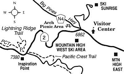
Scan distant horizons from the Lightning Ridge Trail atop the Angeles Crest.
On the eastern Angeles Crest, not far above the L.A. Basin's smoggy blanket of air, lies Big Pines Recreation Area -- a designated year-round recreation zone in Angeles National Forest. Blanketed by a heterogeneous mixture of pines, firs, and oaks, Big Pines boasts the clean, dry, evergreen-scented air and crystalline blue skies characteristic of the melding of mountain and desert environments. Winter and spring skiing (sometimes aided by the labors of snow-making machines) is offered at three sites in the Big Pines area. Several trails lace the area, including one of the finer interpretive trails around: Lightning Ridge Trail.
From San Diego, the direct route to Big Pines takes you north on Interstate 15 past San Bernardino to the Highway 138 exit at Cajon Junction. Drive 8.6 miles west on Highway 138 to the junction of Highway 2 (Angeles Crest Highway). Turn left there, and continue uphill into the pine-clad San Gabriel Mountains and through the sprawling mountain town of Wrightwood. At a point 10 miles from Highway 138 you'll come to Big Pines, where you can drop by the Forest Service's Grassy Hollow visitors' center. The facility, open Wednesday though Sunday, offers leaflets, maps, interpretive brochures for nearby trails, and reference materials such as a wildflower identification guide. At this elevation of about 7000 feet, several kinds of flowers are still in bloom.
Lightning Ridge Trail, two miles farther west from the visitors' center, starts opposite a roadside stop known as Inspiration Point. On the 0.8-mile-long trail, you'll start by contouring through the cool precincts of a wooded northeast-facing slope. You'll see Jeffrey pines, sugar pines, and white firs, and you'll pass right through a beautiful glade of black oaks called Oak Dell. These oaks are in a summer-green stage right now -- and they'll look even nicer in October when their leaves turn crispy gold.
Now you're zigzagging upward. As you approach the exposed ridgeline ahead, note the stunted and distorted trees. They're battered by occasional fierce winds and flattened by snow drifts that can pile up ten feet high.
On the crest itself you'll meet a segment of the 2600-mile-long Pacific Crest Trail. At this locale, some 14 percent of the PCT's winding course leads south to the Mexican border, and about 86 percent leads north to the Canadian border.
On the crest, the view of nearby high points in the San Gabriel Mountains is similar to that from Inspiration Point below, only a bit more panoramic. Mount San Antonio, a.k.a. Old Baldy, is the tallest of those summits, at just over 10,000 feet.
Here's something you might be interested in.
Scan distant horizons from the Lightning Ridge Trail atop the Angeles Crest.
Scan distant horizons from the Lightning Ridge Trail atop the Angeles Crest.
On the eastern Angeles Crest, not far above the L.A. Basin's smoggy blanket of air, lies Big Pines Recreation Area -- a designated year-round recreation zone in Angeles National Forest. Blanketed by a heterogeneous mixture of pines, firs, and oaks, Big Pines boasts the clean, dry, evergreen-scented air and crystalline blue skies characteristic of the melding of mountain and desert environments. Winter and spring skiing (sometimes aided by the labors of snow-making machines) is offered at three sites in the Big Pines area. Several trails lace the area, including one of the finer interpretive trails around: Lightning Ridge Trail.
From San Diego, the direct route to Big Pines takes you north on Interstate 15 past San Bernardino to the Highway 138 exit at Cajon Junction. Drive 8.6 miles west on Highway 138 to the junction of Highway 2 (Angeles Crest Highway). Turn left there, and continue uphill into the pine-clad San Gabriel Mountains and through the sprawling mountain town of Wrightwood. At a point 10 miles from Highway 138 you'll come to Big Pines, where you can drop by the Forest Service's Grassy Hollow visitors' center. The facility, open Wednesday though Sunday, offers leaflets, maps, interpretive brochures for nearby trails, and reference materials such as a wildflower identification guide. At this elevation of about 7000 feet, several kinds of flowers are still in bloom.
Lightning Ridge Trail, two miles farther west from the visitors' center, starts opposite a roadside stop known as Inspiration Point. On the 0.8-mile-long trail, you'll start by contouring through the cool precincts of a wooded northeast-facing slope. You'll see Jeffrey pines, sugar pines, and white firs, and you'll pass right through a beautiful glade of black oaks called Oak Dell. These oaks are in a summer-green stage right now -- and they'll look even nicer in October when their leaves turn crispy gold.
Now you're zigzagging upward. As you approach the exposed ridgeline ahead, note the stunted and distorted trees. They're battered by occasional fierce winds and flattened by snow drifts that can pile up ten feet high.
On the crest itself you'll meet a segment of the 2600-mile-long Pacific Crest Trail. At this locale, some 14 percent of the PCT's winding course leads south to the Mexican border, and about 86 percent leads north to the Canadian border.
On the crest, the view of nearby high points in the San Gabriel Mountains is similar to that from Inspiration Point below, only a bit more panoramic. Mount San Antonio, a.k.a. Old Baldy, is the tallest of those summits, at just over 10,000 feet.