Here's something you might be interested in.
Ask a Hipster — Advice you didn't know you needed
Big Screen — Movie commentary
Blurt — Music's inside track
Booze News — San Diego spirits
Classical Music — Immortal beauty
Classifieds — Free and easy
Cover Stories — Front-page features
Drinks All Around — Bartenders' drink recipes
Excerpts — Literary and spiritual excerpts
Feast! — Food & drink reviews
Feature Stories — Local news & stories
Fishing Report — What’s getting hooked from ship and shore
From the Archives — Spotlight on the past
Golden Dreams — Talk of the town
The Gonzo Report — Making the musical scene, or at least reporting from it
Letters — Our inbox
Movies@Home — Local movie buffs share favorites
Movie Reviews — Our critics' picks and pans
Musician Interviews — Up close with local artists
Neighborhood News from Stringers — Hyperlocal news
News Ticker — News & politics
Obermeyer — San Diego politics illustrated
Outdoors — Weekly changes in flora and fauna
Overheard in San Diego — Eavesdropping illustrated
Poetry — The old and the new
Reader Travel — Travel section built by travelers
Reading — The hunt for intellectuals
Roam-O-Rama — SoCal's best hiking/biking trails
San Diego Beer — Inside San Diego suds
SD on the QT — Almost factual news
Sheep and Goats — Places of worship
Special Issues — The best of
Street Style — San Diego streets have style
Surf Diego — Real stories from those braving the waves
Theater — On stage in San Diego this week
Tin Fork — Silver spoon alternative
Under the Radar — Matt Potter's undercover work
Unforgettable — Long-ago San Diego
Unreal Estate — San Diego's priciest pads
Your Week — Daily event picks
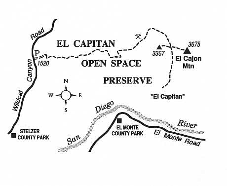
Tackle severe ups and downs on the old mining track through El Capitan Open Space Reserve near Lakeside.
If you have the fortitude to tackle some killer ups and downs, try the surprisingly challenging hiking route to El Cajon Mountain, a picturesque East County landmark. Your primary destination is the 3675-foot-high point along the mountain's summit ridge. A side trip, with considerable extra effort, can take you to the top of the sheer south escarpment of the same mountain, a feature known as El Capitan.
From Mapleview Street in Lakeside, just east of Highway 67, drive 4.2 miles north on Wildcat Canyon Road to the El Capitan Open-Space Preserve trailhead parking lot on the right.
With small exceptions, the route follows an unpaved road bulldozed on public (former BLM) land by miners many years ago. Currently, parts of the mining road are being incorporated into the Trans-County Trail, which will eventually stretch from Los Peñasquitos Lagoon near Del Mar to Borrego Springs.
At present, you're directed east from the parking lot along an access road leading to the private Blue Sky Ranch. After bypassing the ranch property and ascending a short, steep switchbacking trail, you hook up with the old mining road and soon arrive at a rest stop on the left, with a picnic bench and a post declaring "1 mile." When completed, a new segment of trail swinging clear of the Blue Sky Ranch will converge at this same spot.
As you reach a small summit, around 1.2 miles, and start descending, the round top and sheer south brow of El Cajon Mountain (El Capitan) becomes visible in the middle distance. A very steep uphill pitch, commencing at about 3.0 miles, will surely reduce you to painfully slow uphill scrambling, if only for a few minutes. At just under 4 miles, you reach another significant summit. From this spot, a short side path leads north to some abandoned mines -- shallow tunnels cut into a chalky hillside.
Like Sisyphus, your elevation gain is tragically interrupted just ahead. You sink 300 feet in less than a half mile on a slippery, decomposing granite surface, before once again resuming uphill progress. At 4.7 miles there's a rock-lined spring on the left, recently dry due to the prolonged drought. At 5.5 miles, the road arrives on a saddle between El Cajon Mountain's summit on the left (east) and a smaller 3367-foot peak on the right (west). You'll be retracing your steps from this point to get back to your car. Ahead, though, you have three choices for further exploration.
By turning right (west) and walking 0.2 mile, you reach a 3367-foot summit featuring a very nice panoramic view west and south. By turning left (east) you can follow a narrow but well-beaten path threading 0.5 mile through thick chaparral and around jumbo-sized boulders to El Cajon Mountain's rounded summit. The view from there is panoramic in all directions.
The third, most difficult alternative is a 1.4-mile-long trek straight ahead (south) from the saddle, using a severely eroded and partially overgrown roadbed. This route takes you to the sheer brow of El Capitan. Walk out to the edge, beyond the end of the old roadbed, and descend over boulders 50 or 100 yards for a pseudo-aerial view of the San Diego River Valley and El Capitan Reservoir, complete with toylike boats floating on its blue surface.
Even without these options, the round-trip distance to the saddle and back is 11 miles with elevation gains of about 4000 feet. This is a serious effort, requiring five to eight hours of hiking time, and lots and lots of water, even in late autumn.
Here's something you might be interested in.
Tackle severe ups and downs on the old mining track through El Capitan Open Space Reserve near Lakeside.
Tackle severe ups and downs on the old mining track through El Capitan Open Space Reserve near Lakeside.
If you have the fortitude to tackle some killer ups and downs, try the surprisingly challenging hiking route to El Cajon Mountain, a picturesque East County landmark. Your primary destination is the 3675-foot-high point along the mountain's summit ridge. A side trip, with considerable extra effort, can take you to the top of the sheer south escarpment of the same mountain, a feature known as El Capitan.
From Mapleview Street in Lakeside, just east of Highway 67, drive 4.2 miles north on Wildcat Canyon Road to the El Capitan Open-Space Preserve trailhead parking lot on the right.
With small exceptions, the route follows an unpaved road bulldozed on public (former BLM) land by miners many years ago. Currently, parts of the mining road are being incorporated into the Trans-County Trail, which will eventually stretch from Los Peñasquitos Lagoon near Del Mar to Borrego Springs.
At present, you're directed east from the parking lot along an access road leading to the private Blue Sky Ranch. After bypassing the ranch property and ascending a short, steep switchbacking trail, you hook up with the old mining road and soon arrive at a rest stop on the left, with a picnic bench and a post declaring "1 mile." When completed, a new segment of trail swinging clear of the Blue Sky Ranch will converge at this same spot.
As you reach a small summit, around 1.2 miles, and start descending, the round top and sheer south brow of El Cajon Mountain (El Capitan) becomes visible in the middle distance. A very steep uphill pitch, commencing at about 3.0 miles, will surely reduce you to painfully slow uphill scrambling, if only for a few minutes. At just under 4 miles, you reach another significant summit. From this spot, a short side path leads north to some abandoned mines -- shallow tunnels cut into a chalky hillside.
Like Sisyphus, your elevation gain is tragically interrupted just ahead. You sink 300 feet in less than a half mile on a slippery, decomposing granite surface, before once again resuming uphill progress. At 4.7 miles there's a rock-lined spring on the left, recently dry due to the prolonged drought. At 5.5 miles, the road arrives on a saddle between El Cajon Mountain's summit on the left (east) and a smaller 3367-foot peak on the right (west). You'll be retracing your steps from this point to get back to your car. Ahead, though, you have three choices for further exploration.
By turning right (west) and walking 0.2 mile, you reach a 3367-foot summit featuring a very nice panoramic view west and south. By turning left (east) you can follow a narrow but well-beaten path threading 0.5 mile through thick chaparral and around jumbo-sized boulders to El Cajon Mountain's rounded summit. The view from there is panoramic in all directions.
The third, most difficult alternative is a 1.4-mile-long trek straight ahead (south) from the saddle, using a severely eroded and partially overgrown roadbed. This route takes you to the sheer brow of El Capitan. Walk out to the edge, beyond the end of the old roadbed, and descend over boulders 50 or 100 yards for a pseudo-aerial view of the San Diego River Valley and El Capitan Reservoir, complete with toylike boats floating on its blue surface.
Even without these options, the round-trip distance to the saddle and back is 11 miles with elevation gains of about 4000 feet. This is a serious effort, requiring five to eight hours of hiking time, and lots and lots of water, even in late autumn.