Sponsored
Sponsored
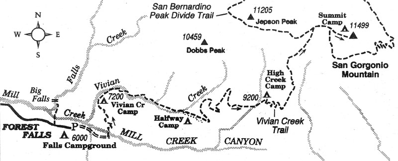
The barren 11.5K-foot summit of San Gorgonio Mountain, the highest elevation in Southern California, is a classic destination for San Diego hikers. The century-old Vivian Creek Trail route to the top from the south is the easiest of about eight distinct routes or variations; even so, you face a round-trip of 15.6 miles with a total elevation gain and loss of 5700 feet. Some people backpack the route over two or three days, while fit dayhikers clock in at ten hours or less. Be aware that until about mid-September dangerous afternoon thunderstorms may visit Gorgonio's higher slopes.
Whether dayhiking or backpacking, you must secure a wilderness permit from the Mill Creek Ranger Station, at Mill Creek Road (Highway 38) and Bryant Street, east of Redlands. You will pass this facility if you are driving up from San Diego by going through San Bernardino and Redlands. The station currently opens at 8 a.m. weekdays and 6:30 a.m. weekends. Some permits may be available by self-registration outside the door before those hours. Others may be available in advance by mail. You will also need a National Forest Adventure Pass ($5) per day, for parking at the trailhead. Call 909-794-1123 for more information.
The trailhead lies at the east end of Valley of the Falls Boulevard (Forest Home Road), just east of the cabin community of Forest Falls. Valley of the Falls Boulevard intersects Highway 38 at a point 6.2 miles east of the Mill Creek Station and 14 miles east of Redlands.
From the paved parking lot at the road end, walk east (uphill) past a vehicle gate and follow a dirt road for 0.6 mile to its end. Go left across the wide boulder wash of Mill Creek and find the Vivian Creek Trail going sharply up the oak-clothed canyon wall on the far side. The next half mile is excruciatingly steep; and this pitch is worse on the return, when your weary quadricep muscles must absorb the punishment of each lurching downhill step.
Mercifully, at the top of the steep section, the trail levels momentarily, then assumes a moderate grade up alongside Vivian Creek. A sylvan Shangri-la unfolds ahead. Pines, firs, and cedars reach for the sky. Bracken fern smothers the banks of the melodious creek, which dances over boulders and fallen trees.
Near Halfway Camp (2.5 miles) the trail begins climbing timber-dotted slopes covered intermittently by thickets of manzanita. After several zigs and zags on north-facing slopes, you swing onto a brightly illuminated south-facing slope. Soon thereafter, the sound of bubbling water heralds your arrival at High Creek (4.8 miles) and the trail camp of the same name. Be ready for a chilly night if you stay here; cold, nocturnal air often flows down along the bottom of this canyon from the 10,000-foot-plus peaks above.
Past High Creek Camp the trail ascends gently on several long switchback segments through lodgepole pines and at length attains a saddle on a rocky ridge. The pines thin out and appear more decrepit as you climb crookedly up along this ridge toward timberline. At 7.2 miles, the San Bernardino Peak Divide Trail intersects from the left. Stay right and keep climbing on a moderate grade across stony slopes dotted with stunted pines.
On the right you pass Sky High Trail, which bends around the mountain and descends toward Dry Lake and South Fork Meadows in the north. Don't give up! Keep straight and keep going. A final burst of effort puts you on a boulder pile marking the top of the San Bernardino mountain range.