Here's something you might be interested in.
Ask a Hipster — Advice you didn't know you needed
Big Screen — Movie commentary
Blurt — Music's inside track
Booze News — San Diego spirits
Classical Music — Immortal beauty
Classifieds — Free and easy
Cover Stories — Front-page features
Drinks All Around — Bartenders' drink recipes
Excerpts — Literary and spiritual excerpts
Feast! — Food & drink reviews
Feature Stories — Local news & stories
Fishing Report — What’s getting hooked from ship and shore
From the Archives — Spotlight on the past
Golden Dreams — Talk of the town
The Gonzo Report — Making the musical scene, or at least reporting from it
Letters — Our inbox
Movies@Home — Local movie buffs share favorites
Movie Reviews — Our critics' picks and pans
Musician Interviews — Up close with local artists
Neighborhood News from Stringers — Hyperlocal news
News Ticker — News & politics
Obermeyer — San Diego politics illustrated
Outdoors — Weekly changes in flora and fauna
Overheard in San Diego — Eavesdropping illustrated
Poetry — The old and the new
Reader Travel — Travel section built by travelers
Reading — The hunt for intellectuals
Roam-O-Rama — SoCal's best hiking/biking trails
San Diego Beer — Inside San Diego suds
SD on the QT — Almost factual news
Sheep and Goats — Places of worship
Special Issues — The best of
Street Style — San Diego streets have style
Surf Diego — Real stories from those braving the waves
Theater — On stage in San Diego this week
Tin Fork — Silver spoon alternative
Under the Radar — Matt Potter's undercover work
Unforgettable — Long-ago San Diego
Unreal Estate — San Diego's priciest pads
Your Week — Daily event picks
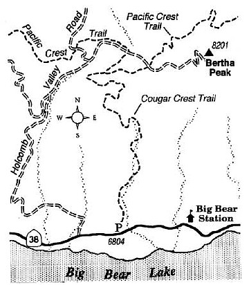
Hike the Cougar Crest Trail, rising on the slope north of Big Bear Lake.
The Big Bear Lake region offers some fine outdoor experiences for those willing to stretch their legs a bit. Some of the better hiking routes can be found on the sloping mountain rim that rises above the serene and mostly undeveloped north shore of the lake. It is here that the recently completed Cougar Crest Trail ascends to a junction with the 2600-mile-long Pacific Crest Trail -- the world's longest maintained footpath.
The starting point, on Highway 38 some two miles east of the village of Fawnskin, and four miles west of Big Bear City, is hard to miss. Park in the spacious paved lot at the trailhead (and be sure to display your National Forest Adventure Pass), and start heading up the Cougar Crest Trail, formerly an obscure dirt road. Traces of mining activity are evident as you climb upward along a shallow draw filled with a delightful mix of outsized pinyon pines and junipers and occasional straight and tall Jeffrey pines. The mingling of the sweet and pungent scents exuded by the wood and needles of these trees is intoxicating on a warm day.
After a long mile, the old road becomes a narrow trail and begins to curl and switchback along higher and sunnier slopes. Big Bear Lake comes into view occasionally, its surface azure in the morning and often dotted with silvery pinpoints of reflected sunlight in the afternoon.
After about 2 miles, the trail reaches a divide, bends right, and for a short distance traverses a cool, north-facing slope. At 2.2 miles, the Cougar Crest Trail joins the Pacific Crest Trail -- the latter a path reserved for hikers and horses only (no mountain bikes allowed). You bear right and start contouring east, high on the sunny, south-facing slope. Spread before you now is the lake (actually a shallow reservoir), which half-fills a 10-mile-long trough in the mountains and the various resort and residential communities spread along the shore and beyond. Behind the lake and about 12 miles distant, rise the rounded 10,000-plus-foot ramparts of the San Bernardino Mountain crest.
The southern view does not significantly improve as you press on, though the high point ahead, Bertha Peak, will furnish a better view in other directions. When the Pacific Crest Trail crosses a rock-strewn service road (2.6 miles from the start), leave the nicely graded trail and start climbing east on the road. A sweaty 0.7-mile ascent takes you to a small microwave relay station atop Bertha Peak. From there, 3.3 miles from the Cougar Crest trailhead, you can look over the treetops into Holcomb Valley and the Mojave Desert to the north. When it's time to go, simply retrace your steps.
Here's something you might be interested in.
Hike the Cougar Crest Trail, rising on the slope north of Big Bear Lake.
Hike the Cougar Crest Trail, rising on the slope north of Big Bear Lake.
The Big Bear Lake region offers some fine outdoor experiences for those willing to stretch their legs a bit. Some of the better hiking routes can be found on the sloping mountain rim that rises above the serene and mostly undeveloped north shore of the lake. It is here that the recently completed Cougar Crest Trail ascends to a junction with the 2600-mile-long Pacific Crest Trail -- the world's longest maintained footpath.
The starting point, on Highway 38 some two miles east of the village of Fawnskin, and four miles west of Big Bear City, is hard to miss. Park in the spacious paved lot at the trailhead (and be sure to display your National Forest Adventure Pass), and start heading up the Cougar Crest Trail, formerly an obscure dirt road. Traces of mining activity are evident as you climb upward along a shallow draw filled with a delightful mix of outsized pinyon pines and junipers and occasional straight and tall Jeffrey pines. The mingling of the sweet and pungent scents exuded by the wood and needles of these trees is intoxicating on a warm day.
After a long mile, the old road becomes a narrow trail and begins to curl and switchback along higher and sunnier slopes. Big Bear Lake comes into view occasionally, its surface azure in the morning and often dotted with silvery pinpoints of reflected sunlight in the afternoon.
After about 2 miles, the trail reaches a divide, bends right, and for a short distance traverses a cool, north-facing slope. At 2.2 miles, the Cougar Crest Trail joins the Pacific Crest Trail -- the latter a path reserved for hikers and horses only (no mountain bikes allowed). You bear right and start contouring east, high on the sunny, south-facing slope. Spread before you now is the lake (actually a shallow reservoir), which half-fills a 10-mile-long trough in the mountains and the various resort and residential communities spread along the shore and beyond. Behind the lake and about 12 miles distant, rise the rounded 10,000-plus-foot ramparts of the San Bernardino Mountain crest.
The southern view does not significantly improve as you press on, though the high point ahead, Bertha Peak, will furnish a better view in other directions. When the Pacific Crest Trail crosses a rock-strewn service road (2.6 miles from the start), leave the nicely graded trail and start climbing east on the road. A sweaty 0.7-mile ascent takes you to a small microwave relay station atop Bertha Peak. From there, 3.3 miles from the Cougar Crest trailhead, you can look over the treetops into Holcomb Valley and the Mojave Desert to the north. When it's time to go, simply retrace your steps.