Here's something you might be interested in.
Ask a Hipster — Advice you didn't know you needed
Big Screen — Movie commentary
Blurt — Music's inside track
Booze News — San Diego spirits
Classical Music — Immortal beauty
Classifieds — Free and easy
Cover Stories — Front-page features
Drinks All Around — Bartenders' drink recipes
Excerpts — Literary and spiritual excerpts
Feast! — Food & drink reviews
Feature Stories — Local news & stories
Fishing Report — What’s getting hooked from ship and shore
From the Archives — Spotlight on the past
Golden Dreams — Talk of the town
The Gonzo Report — Making the musical scene, or at least reporting from it
Letters — Our inbox
Movies@Home — Local movie buffs share favorites
Movie Reviews — Our critics' picks and pans
Musician Interviews — Up close with local artists
Neighborhood News from Stringers — Hyperlocal news
News Ticker — News & politics
Obermeyer — San Diego politics illustrated
Outdoors — Weekly changes in flora and fauna
Overheard in San Diego — Eavesdropping illustrated
Poetry — The old and the new
Reader Travel — Travel section built by travelers
Reading — The hunt for intellectuals
Roam-O-Rama — SoCal's best hiking/biking trails
San Diego Beer — Inside San Diego suds
SD on the QT — Almost factual news
Sheep and Goats — Places of worship
Special Issues — The best of
Street Style — San Diego streets have style
Surf Diego — Real stories from those braving the waves
Theater — On stage in San Diego this week
Tin Fork — Silver spoon alternative
Under the Radar — Matt Potter's undercover work
Unforgettable — Long-ago San Diego
Unreal Estate — San Diego's priciest pads
Your Week — Daily event picks
Climb Sitton Peak in the Santa Ana Mountains for views of the ocean and of toylike cars
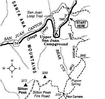
From below, 3273-foot Sitton Peak looks unimposing -- a bump atop the rambling Santa Ana Mountains, just north of the San Diego County line. On the summit, though, the feeling is decidedly "top of the world." When an east or north wind blows, cleansing the sky of water vapor and air pollution, 50-mile vistas in every direction are not uncommon.
The pleasantly challenging, 9.5-mile-round-trip hike to the summit begins along Ortega Highway (Highway 74), 19.5 miles east of Interstate 5 at San Juan Capistrano. On the right at that point is the homey Ortega Oaks Store, and on the left is a large trailhead parking area. Starting off from the store, walk south on the well-worn, moderately ascending Bear Canyon Trail for 1.0 mile to a trail junction in a patch of oak woodland. Go right (the Morgan Trail forks left) and begin climbing more steeply along a chaparral-clothed slope. At about 2.0 miles, you reach an old truck trail, now reserved for hikers only. You can either cross this old road and go straight on a newer footpath, or go right on the road that is designated as the Bear Canyon Trail. Either way you eventually arrive at a saddle called Four Corners (3.2 miles), where four old roads and the newer footpath join together. Swing right on the road that climbs northwest -- a disused section of Sitton Peak Fire Road. After a steady ascent of about 300 vertical feet, you reach a flat area (4.0 miles) just below a boulder-studded ridge (3250-foot elevation) to the north. You could straightforwardly climb to the top of this ridge, but the view from Sitton Peak ahead is somewhat better.
Beyond the flat area the road descends another 0.5 mile to a saddle just below Sitton Peak. From this saddle, you leave the road and follow a steep, informal trail up through scattered manzanita and chamise on the east slope of the peak.
The view from the top is especially impressive to the west. Here the foothills and western canyons of the Santa Ana Mountains merge with the creeping suburbs of southern Orange County. Beyond lies the flat, blue ocean punctuated by the profile of Santa Catalina Island. Some 2000 vertical feet below, toylike cars on Highway 74 make their way down the sinuous course of San Juan Canyon.
Here's something you might be interested in.
Climb Sitton Peak in the Santa Ana Mountains for views of the ocean and of toylike cars
Climb Sitton Peak in the Santa Ana Mountains for views of the ocean and of toylike cars
From below, 3273-foot Sitton Peak looks unimposing -- a bump atop the rambling Santa Ana Mountains, just north of the San Diego County line. On the summit, though, the feeling is decidedly "top of the world." When an east or north wind blows, cleansing the sky of water vapor and air pollution, 50-mile vistas in every direction are not uncommon.
The pleasantly challenging, 9.5-mile-round-trip hike to the summit begins along Ortega Highway (Highway 74), 19.5 miles east of Interstate 5 at San Juan Capistrano. On the right at that point is the homey Ortega Oaks Store, and on the left is a large trailhead parking area. Starting off from the store, walk south on the well-worn, moderately ascending Bear Canyon Trail for 1.0 mile to a trail junction in a patch of oak woodland. Go right (the Morgan Trail forks left) and begin climbing more steeply along a chaparral-clothed slope. At about 2.0 miles, you reach an old truck trail, now reserved for hikers only. You can either cross this old road and go straight on a newer footpath, or go right on the road that is designated as the Bear Canyon Trail. Either way you eventually arrive at a saddle called Four Corners (3.2 miles), where four old roads and the newer footpath join together. Swing right on the road that climbs northwest -- a disused section of Sitton Peak Fire Road. After a steady ascent of about 300 vertical feet, you reach a flat area (4.0 miles) just below a boulder-studded ridge (3250-foot elevation) to the north. You could straightforwardly climb to the top of this ridge, but the view from Sitton Peak ahead is somewhat better.
Beyond the flat area the road descends another 0.5 mile to a saddle just below Sitton Peak. From this saddle, you leave the road and follow a steep, informal trail up through scattered manzanita and chamise on the east slope of the peak.
The view from the top is especially impressive to the west. Here the foothills and western canyons of the Santa Ana Mountains merge with the creeping suburbs of southern Orange County. Beyond lies the flat, blue ocean punctuated by the profile of Santa Catalina Island. Some 2000 vertical feet below, toylike cars on Highway 74 make their way down the sinuous course of San Juan Canyon.