Here's something you might be interested in.
Ask a Hipster — Advice you didn't know you needed
Big Screen — Movie commentary
Blurt — Music's inside track
Booze News — San Diego spirits
Classical Music — Immortal beauty
Classifieds — Free and easy
Cover Stories — Front-page features
Drinks All Around — Bartenders' drink recipes
Excerpts — Literary and spiritual excerpts
Feast! — Food & drink reviews
Feature Stories — Local news & stories
Fishing Report — What’s getting hooked from ship and shore
From the Archives — Spotlight on the past
Golden Dreams — Talk of the town
The Gonzo Report — Making the musical scene, or at least reporting from it
Letters — Our inbox
Movies@Home — Local movie buffs share favorites
Movie Reviews — Our critics' picks and pans
Musician Interviews — Up close with local artists
Neighborhood News from Stringers — Hyperlocal news
News Ticker — News & politics
Obermeyer — San Diego politics illustrated
Outdoors — Weekly changes in flora and fauna
Overheard in San Diego — Eavesdropping illustrated
Poetry — The old and the new
Reader Travel — Travel section built by travelers
Reading — The hunt for intellectuals
Roam-O-Rama — SoCal's best hiking/biking trails
San Diego Beer — Inside San Diego suds
SD on the QT — Almost factual news
Sheep and Goats — Places of worship
Special Issues — The best of
Street Style — San Diego streets have style
Surf Diego — Real stories from those braving the waves
Theater — On stage in San Diego this week
Tin Fork — Silver spoon alternative
Under the Radar — Matt Potter's undercover work
Unforgettable — Long-ago San Diego
Unreal Estate — San Diego's priciest pads
Your Week — Daily event picks
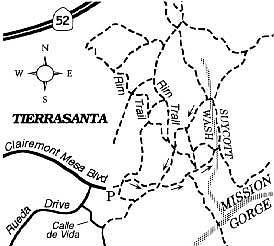
Mission Trails Regional Park and the Suycott Wash
Last May, Mission Trails Regional Park opened a new trailhead parking lot and gateway that provides easy access to the park's western area from the community of Tierrasanta. To check out and make use of this new entry, simply follow Clairemont Mesa Boulevard to its east dead-end in Tierrasanta. On foot or bike you can proceed farther east using a dense network of dirt roads and trails covering the hills and valleys like a tattered net.
A sign at the start advises that the parkland ahead encompasses part of the former Camp Elliott, a World War II gunnery range. Thorough sweeps for unexploded ordnance have largely (though presumably not totally) eliminated the chance of coming across decades-old duds.
A nice, easy two-mile-loop hike to Suycott Wash, perfect for the cool of a summer morning or early evening, can be fashioned out of the trails radiating from the new trailhead. First you cross over a deep ravine on a sturdy, wood-planked bridge, built several years ago to support truck traffic during an upgrade project along the Second San Diego Aqueduct. On the far side of the bridge, turn left and hike for a minute on an old roadbed toward a narrow path intersecting on the right. Follow this contouring path a few minutes to a wide dirt road on a saddle, cross that road, and head east on another road descending into a valley. Follow the signs to "South Suycott," taking care that you do not swing too far right and descend the steep road leading to the bottom of Mission Gorge.
Suycott Wash, better described as a ravine than a wash, harbors shade-giving live oaks and (just recently) puddles of water left over from the meager rains of last winter. When you reach the bottom of the ravine, look for a shady picnic site on your left. Just two weeks ago, I startled a deer near here, who departed from my sight in a blur.
From the picnic tables, follow the shady Suycott ravine northward (upstream), then go left at the next dirt road you encounter. Use this to climb back up to the saddle, and then retrace your steps on the narrow, contouring trail you followed earlier.
Here's something you might be interested in.
Mission Trails Regional Park and the Suycott Wash
Mission Trails Regional Park and the Suycott Wash
Last May, Mission Trails Regional Park opened a new trailhead parking lot and gateway that provides easy access to the park's western area from the community of Tierrasanta. To check out and make use of this new entry, simply follow Clairemont Mesa Boulevard to its east dead-end in Tierrasanta. On foot or bike you can proceed farther east using a dense network of dirt roads and trails covering the hills and valleys like a tattered net.
A sign at the start advises that the parkland ahead encompasses part of the former Camp Elliott, a World War II gunnery range. Thorough sweeps for unexploded ordnance have largely (though presumably not totally) eliminated the chance of coming across decades-old duds.
A nice, easy two-mile-loop hike to Suycott Wash, perfect for the cool of a summer morning or early evening, can be fashioned out of the trails radiating from the new trailhead. First you cross over a deep ravine on a sturdy, wood-planked bridge, built several years ago to support truck traffic during an upgrade project along the Second San Diego Aqueduct. On the far side of the bridge, turn left and hike for a minute on an old roadbed toward a narrow path intersecting on the right. Follow this contouring path a few minutes to a wide dirt road on a saddle, cross that road, and head east on another road descending into a valley. Follow the signs to "South Suycott," taking care that you do not swing too far right and descend the steep road leading to the bottom of Mission Gorge.
Suycott Wash, better described as a ravine than a wash, harbors shade-giving live oaks and (just recently) puddles of water left over from the meager rains of last winter. When you reach the bottom of the ravine, look for a shady picnic site on your left. Just two weeks ago, I startled a deer near here, who departed from my sight in a blur.
From the picnic tables, follow the shady Suycott ravine northward (upstream), then go left at the next dirt road you encounter. Use this to climb back up to the saddle, and then retrace your steps on the narrow, contouring trail you followed earlier.