Sponsored
Sponsored
"Peak-baggers” by the thousands earn personal satisfaction by climbing notable high points throughout California. No such interest is directed toward the state’s low points — except maybe the attention given to the lowest spot in the Western Hemisphere. This obscure but remarkable place in Death Valley is six hours away from San Diego — about five hours of driving, plus an hour of walking.
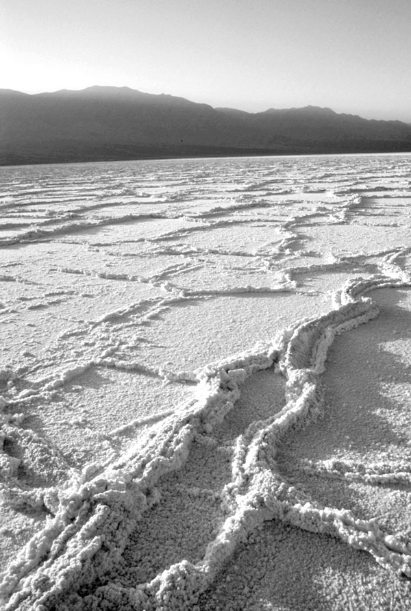
For hundreds of millennia, runoff rich in dissolved minerals from a vast area of eastern California has been steered by gravity into the vast landlocked basin of Death Valley. During the last ice age the runoff rushed in fast enough and often enough to form a deep, permanent lake on the valley floor. But now that we’re in a much drier time, any lake that manages to appear here dries up very quickly. As the water evaporates, salt is left behind in a crystallized form. This salt is primarily sodium chloride, or common table salt, because this mineral is the most abundant of those dissolved in the water.
One place to start a hike to the low point is Badwater, 18 miles south of Death Valley National Park’s visitors’ center at Furnace Creek. An interpretive panel and direction finder at Badwater arrows two separate points in the valley that have supposedly been surveyed as lowest points. Commonly available maps, however, show only one point, which is 3.3 miles away. There’s a whopping three feet of elevation loss from Badwater on down to this low point, so don’t forget the uphill climb you must make on the way back.
The Badwater approach is a good one if you want to hike only a short distance, because less than one-half mile of walking takes you to the edge of the salt pan, where the crystallized salt has formed fascinating polygonal patterns on the ground. The long trek to the low point from this edge features much more of the same scenery.
For those who simply must get to the very lowest point in the Western Hemisphere, I’d suggest a shorter approach from across the valley. Use the unpaved West Side Road to reach Tule Spring, which is 1.2 miles north of the junction of the dirt road ascending into Hanaupah Canyon. From Tule Spring, the hike is only 2.3 miles almost due east. This is a more interesting approach, as you first traverse some higher ground rich in calcium salts and then hit the hard crust of sodium chloride about halfway to your destination.
Only a fool would venture on the glaring salt pan during Death Valley’s hellish summers, but winter is surprisingly cool here — a bit cooler than Anza-Borrego. The other general caveat — not likely to be an issue at all during this dry winter season — is to beware of muddy ground.