Here's something you might be interested in.
Ask a Hipster — Advice you didn't know you needed
Big Screen — Movie commentary
Blurt — Music's inside track
Booze News — San Diego spirits
Classical Music — Immortal beauty
Classifieds — Free and easy
Cover Stories — Front-page features
Drinks All Around — Bartenders' drink recipes
Excerpts — Literary and spiritual excerpts
Feast! — Food & drink reviews
Feature Stories — Local news & stories
Fishing Report — What’s getting hooked from ship and shore
From the Archives — Spotlight on the past
Golden Dreams — Talk of the town
The Gonzo Report — Making the musical scene, or at least reporting from it
Letters — Our inbox
Movies@Home — Local movie buffs share favorites
Movie Reviews — Our critics' picks and pans
Musician Interviews — Up close with local artists
Neighborhood News from Stringers — Hyperlocal news
News Ticker — News & politics
Obermeyer — San Diego politics illustrated
Outdoors — Weekly changes in flora and fauna
Overheard in San Diego — Eavesdropping illustrated
Poetry — The old and the new
Reader Travel — Travel section built by travelers
Reading — The hunt for intellectuals
Roam-O-Rama — SoCal's best hiking/biking trails
San Diego Beer — Inside San Diego suds
SD on the QT — Almost factual news
Sheep and Goats — Places of worship
Special Issues — The best of
Street Style — San Diego streets have style
Surf Diego — Real stories from those braving the waves
Theater — On stage in San Diego this week
Tin Fork — Silver spoon alternative
Under the Radar — Matt Potter's undercover work
Unforgettable — Long-ago San Diego
Unreal Estate — San Diego's priciest pads
Your Week — Daily event picks
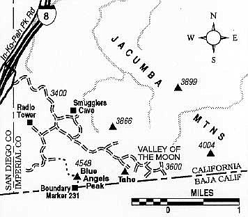
Trek to the rocky summit of Blue Angels Peak near Jacumba.
East of Jacumba, pressed against the California-Baja California border, is a series of scenic peaks and valleys in the Jacumba Mountains affording vistas of two counties (San Diego and Imperial) and two nations. Although American map makers consider this rugged area to be a part of the Jacumba Mountains, it is more closely associated with the 100-mile-long Sierra Juárez, Baja's northernmost link in the chain of Peninsular Ranges. Here you'll see great stacks of weathered boulders, with pinyon pines and other high-desert vegetation growing wherever sand or soil can collect.
Outcrop, Blue Angels Peak
On the five-mile round-trip hike to Blue Angels Peak described here, you'll reach the highest point in "Alta" California that is within six miles of the international border. The peak is surely one of the windiest spots in Southern California -- especially in May, when hot air rising up from the low desert to the east draws in a strong flow of cooler air from the coastal regions.
To reach the starting point, exit Interstate 8 at In-Ko-Pah Park Road (east of Jacumba). Drive southwest 0.2 mile along the frontage road, Old Highway 80, then turn left on an ascending dirt road. If driven slowly, ordinary cars may make it as far as a turnout 0.8 mile up this road. This is the assumed starting point for the hike. Four-wheel-drive vehicles with high clearance should have little trouble going farther, if desired.
From the turnout, walk up the road to a saddle at 3830 feet elevation. An old road branches left toward Smuggler's Cave, an old hideout of bandits and smugglers, now a fire-blackened, graffiti-emblazoned wreck. Proceed another 0.1 mile south and bear right (west). Continue south and finally east to the road end, staying left at two road junctions at 1.1 and 1.4 miles. An old mining prospect lies at the end of the road.
Blue Angels Peak, elevation 4548 feet, is to the southeast, hidden behind a false peak capped by a massive block of granite seemingly poised to roll. Scramble up over lichen-encrusted boulders and past scraggly pinyons to find the bench mark on the summit.
On the return trip, you can make a short detour to discover International Boundary Marker 231, a handsome ten-foot steel obelisk, just south and a little west of the peak. These markers are numbered consecutively along the border from #1 at the Gulf of Mexico shoreline east of Brownsville-Matamoros to #258 at the Pacific shoreline.
Here's something you might be interested in.
Trek to the rocky summit of Blue Angels Peak near Jacumba.
Trek to the rocky summit of Blue Angels Peak near Jacumba.
East of Jacumba, pressed against the California-Baja California border, is a series of scenic peaks and valleys in the Jacumba Mountains affording vistas of two counties (San Diego and Imperial) and two nations. Although American map makers consider this rugged area to be a part of the Jacumba Mountains, it is more closely associated with the 100-mile-long Sierra Juárez, Baja's northernmost link in the chain of Peninsular Ranges. Here you'll see great stacks of weathered boulders, with pinyon pines and other high-desert vegetation growing wherever sand or soil can collect.
Outcrop, Blue Angels Peak
On the five-mile round-trip hike to Blue Angels Peak described here, you'll reach the highest point in "Alta" California that is within six miles of the international border. The peak is surely one of the windiest spots in Southern California -- especially in May, when hot air rising up from the low desert to the east draws in a strong flow of cooler air from the coastal regions.
To reach the starting point, exit Interstate 8 at In-Ko-Pah Park Road (east of Jacumba). Drive southwest 0.2 mile along the frontage road, Old Highway 80, then turn left on an ascending dirt road. If driven slowly, ordinary cars may make it as far as a turnout 0.8 mile up this road. This is the assumed starting point for the hike. Four-wheel-drive vehicles with high clearance should have little trouble going farther, if desired.
From the turnout, walk up the road to a saddle at 3830 feet elevation. An old road branches left toward Smuggler's Cave, an old hideout of bandits and smugglers, now a fire-blackened, graffiti-emblazoned wreck. Proceed another 0.1 mile south and bear right (west). Continue south and finally east to the road end, staying left at two road junctions at 1.1 and 1.4 miles. An old mining prospect lies at the end of the road.
Blue Angels Peak, elevation 4548 feet, is to the southeast, hidden behind a false peak capped by a massive block of granite seemingly poised to roll. Scramble up over lichen-encrusted boulders and past scraggly pinyons to find the bench mark on the summit.
On the return trip, you can make a short detour to discover International Boundary Marker 231, a handsome ten-foot steel obelisk, just south and a little west of the peak. These markers are numbered consecutively along the border from #1 at the Gulf of Mexico shoreline east of Brownsville-Matamoros to #258 at the Pacific shoreline.