Sponsored
Sponsored
North County’s Iron Mountain thrusts its conical summit nearly 2700 feet above sea level, well above any low-lying wintertime haze over the coast and suburbs. On many a crystalline December day, the summit offers a sweeping, 180-degree panorama around either side of the compass, from glistening ocean to blue mountains. Access to the summit — by foot, horse, or mountain bike — is now afforded by the City of Poway’s ever-expanding multi-use trails system.
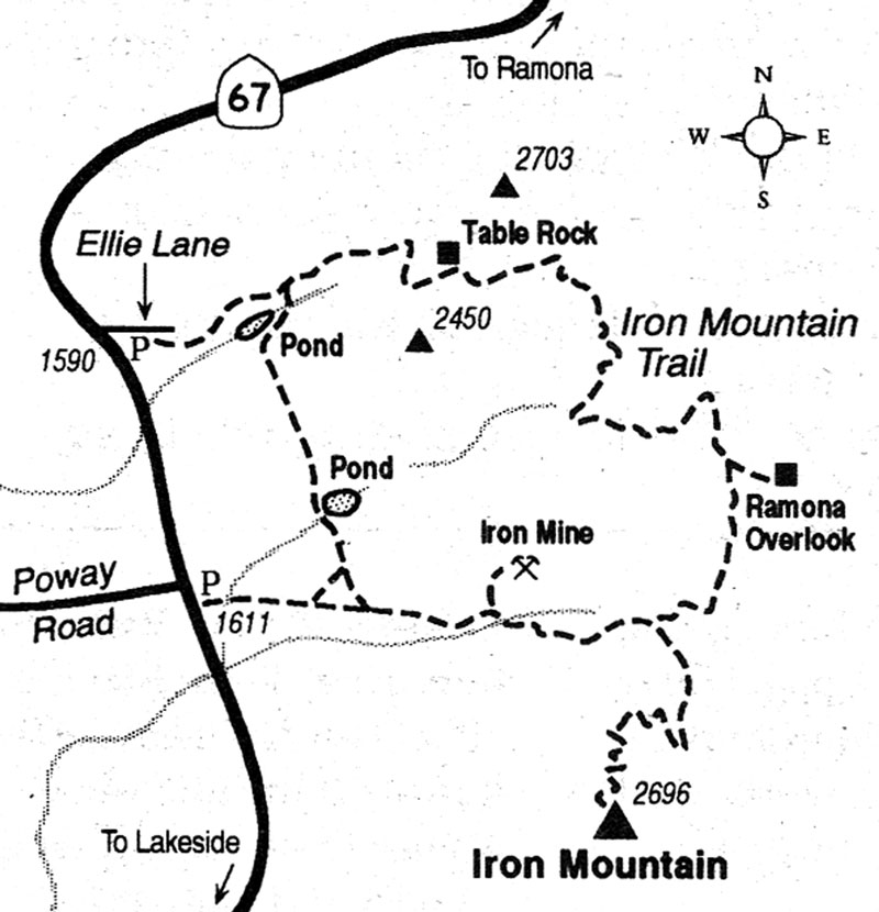
The shorter way up the mountain (3.2 miles one way) takes you along signed pathways from the intersection of Poway Road and State Highway 67 to the summit. I prefer the longer, more wild, and rugged looping route, 9.5 miles for the round trip.
for the longer route, begin at Ellie Lane (0.7 mile north of Poway Road), where the trail starts from a spacious parking lot. In the first couple of miles, you climb through tall growths of chaparral and practically rub shoulders with granodiorite boulders the size of small trucks. A large live oak spreads a pool of shade across the trail at 0.9 mile. At 1.4 miles, you bend around another large oak and soon pass Table Rock, a curious mushroom-like balanced slab of rock. You also get a first glimpse of Iron Mountain, poking up in the south.
Ahead, the trail meanders downward, crosses a small ravine, and zigzags sharply up along a ridge. More switchbacks follow, sharply downhill into another ravine. After that, you’re forced to toil upward yet again on more switchbacks.
Salvation lies on the ridgeline ahead (2.4 miles into the hike), with a glorious view of mile upon mile of olive-green mountains, culminating at the dark-blue wall of the Cuyamacas. After descending from there, you reach (at 2.8 miles) a side trail branching east to a high spot with a good view of Ramona.
At 3.5 miles you arrive at a signed trail junction, where you hook up with the shorter, more heavily traveled route to and from Iron Mountain’s summit. The summit lies only 1.7 miles away, despite the “2 miles” posted.
After visiting the summit, return to the junction, turn left (west), and start descending alongside a broad ravine toward Poway Road and the Ellie Lane trailhead. At a point 50 yards past where you cross the ravine bottom, a side trail goes north almost straight up a hill to a small pit where iron ore was once mined. Dark, dense chunks of the ore lie strewn about — bring along a magnet to confirm their identity.