Sponsored
Sponsored
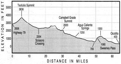
Several factors conspire this time of year to make the bicycle ride down the whole length of Highway S-2 one of the easiest, most carefree and exhilarating experiences you can have in San Diego County. The route, when followed from Highway 79 near Warner Springs to Ocotillo at Interstate 8, drops 2400 feet over 64 miles. There are a couple of non-trivial climbs, to be sure — but mostly you’ll descend in a leisurely stair-step fashion, as the elevation profile printed here suggests. Highway S-2 is seldom busy and has smooth, wide shoulders over most of its length. April’s strong, prevailing winds trend southeast — exactly the direction you’ll go.
All these good things are balanced, as they are for any long, one-way bike trip, by the necessity of some kind of transportation assistance. Ideally, you can recruit a driver with a “sag wagon” who can rendezvous with you at various spots along the way.
Highway S-2’s alignment, which bridges a gap between the hot desert floor and the cooler mountains, was once an important link in the Southern Emigrant Trail, an all-season route into California. In just four or five hours of pedaling and coasting, you’ll travel (on silky pavement and in the opposite direction, of course) the final dreaded passage faced by ragtag settlers on their way to the coast well over a century ago.
Only a few outposts of civilization punctuate the lonely S-2 route: the tiny store at San Felipe, just past Teofulio Summit; Shelter Valley and its store, past Scissors Crossing (Highway 78 crossing); the Butterfield Ranch resort, just before the frightening drop of Campbell Grade; the Vallecito Stage Station; and Agua Caliente Springs, where you can stop for an agreeable soak. Beyond Agua Caliente, you face 26 waterless miles of open road. Take lots of water — early spring time temperatures can climb into the 90s.