Here's something you might be interested in.
Ask a Hipster — Advice you didn't know you needed
Big Screen — Movie commentary
Blurt — Music's inside track
Booze News — San Diego spirits
Classical Music — Immortal beauty
Classifieds — Free and easy
Cover Stories — Front-page features
Drinks All Around — Bartenders' drink recipes
Excerpts — Literary and spiritual excerpts
Feast! — Food & drink reviews
Feature Stories — Local news & stories
Fishing Report — What’s getting hooked from ship and shore
From the Archives — Spotlight on the past
Golden Dreams — Talk of the town
The Gonzo Report — Making the musical scene, or at least reporting from it
Letters — Our inbox
Movies@Home — Local movie buffs share favorites
Movie Reviews — Our critics' picks and pans
Musician Interviews — Up close with local artists
Neighborhood News from Stringers — Hyperlocal news
News Ticker — News & politics
Obermeyer — San Diego politics illustrated
Outdoors — Weekly changes in flora and fauna
Overheard in San Diego — Eavesdropping illustrated
Poetry — The old and the new
Reader Travel — Travel section built by travelers
Reading — The hunt for intellectuals
Roam-O-Rama — SoCal's best hiking/biking trails
San Diego Beer — Inside San Diego suds
SD on the QT — Almost factual news
Sheep and Goats — Places of worship
Special Issues — The best of
Street Style — San Diego streets have style
Surf Diego — Real stories from those braving the waves
Theater — On stage in San Diego this week
Tin Fork — Silver spoon alternative
Under the Radar — Matt Potter's undercover work
Unforgettable — Long-ago San Diego
Unreal Estate — San Diego's priciest pads
Your Week — Daily event picks
Indians, dust, and death along the old Butterfield Overland Stage route
Notes from a wagon seat
The stage route was brought to an end by the Civil War, which made travel through the Confederate states of Texas and Arkansas to Union-supporting California impossible.
Waterman Lily Ormsby pulled into Carrizo station in the early morning hours of October 6. He was not impressed with what he found. There was almost nothing to eat at the crude adobe hut that served as a station house, and the little water that was available tasted of sulfur and salt. Looking around at the low sand hills that surrounded the station, barren except for creosote bushes and twisted, thorny mesquite, Ormsby must have sighed.
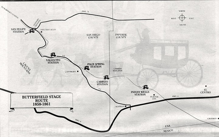
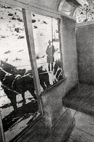
Butterfield route near Vallecito station. From S-2 to Vallecito station the Butterfield trail twists in and out of Vallecito Wash, and many parts of it have been obliterated by flooding.
He had just come more than 2000 miles in a stagecoach that had rolled out of Tipton, Missouri some nineteen days and fourteen hours earlier. The coach had jounced roughly over every stone and furrow along the road, and rattled Ormsby’s head against its wooden sides whenever he tried to sleep. For the last two days, since leaving Yuma, the horses had dragged the coach through the heavy sand of the Colorado Desert — sand so deep that Ormsby often had to get out and walk until the road became harder and more passable.
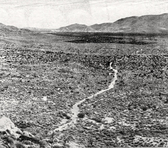
Butterfield stage route. More often the stage trail can be found winding through the desert on either side of S-2, and in several places it swings well away from the paved road.
Then, as the stage neared Carrizo station, it passed a large group of cattle that had been abandoned by a recent wagon train because the animals were too weak to travel. “There they stood," Ormsby wrote later, “almost living skeletons, gradually dying of thirst with water within a few miles of them. I could almost imagine they looked supplicatingly at us, and begged for just one single drop. Some were standing, other lying, and others just gasping in the agonies of death — a sight almost enough to sicken the stoutest heart.”
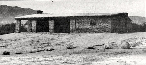
Butterfield stage station at Warner's Ranch, c. 1938. The ranch is the northernmost point in the county to which Remeika has been able to trace the original track of the Butterfield stage.
After all this, Carrizo station, with its bleak setting and god-awful water, must have been a mite disappointing. And Ormsby still had more than 700 miles to go. He was traveling on the Butterfield Overland Stage, which carried mail and passengers from Missouri to San Francisco 125 years ago. Ormsby, a special correspondent for the New York Herald, rode on the first stage to cover the route, and periodically sent accounts of his journey back to New York for all the world to read. The new mail route established a regular land connection between California and the eastern United States for the first time, and Ormsby and his editors at the Herald had the foresight to realize it would be a major factor in the development of the West.
Remeika returned to the spot later that same afternoon and sat in his jeep, staring at the trail. Slowly it sank in: In the dry desert air the 125-year-old road had been preserved in virtually pristine condition. “I couldn't believe it."
Carrizo station (located a few miles east of county road S-2, in Anza-Borrego Desert State Park) has long since turned to dust; all that exists of it today is a layer of stone and charcoal, the remnants of the old station floor. Even the countryside around it has changed. As Paul Remeika and I stand on a hill overlooking the station site we can see thick stands of tamarisk that have invaded Carrizo Creek since Ormsby's time, their wispy tops a beautiful orange-gold now, in early December.
Restored stagecoach. The classic Concord stagecoaches made famous by TV westerns were not used along this stretch of the Butterfield route. Instead, a smaller, lighter coach called a ‘‘mud wagon” was put into use.
Abundant water shines in the creek bed after a summer of heavy rains. But the surrounding terrain is still covered with creosote and mesquite and little else; and the track of the stage itself is still visible, a tan line leading straight as a light beam out of the arid wilderness to the east. “When you see the route sitting there like that, plain as day, it’s enough to send shivers up your spine,” Remeika says.
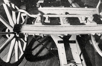
Restored stagecoach, Old Town State Park. The coach had jounced roughly over every stone and furrow along the road, and rattled Ormsby’s head against its wooden sides whenever he tried to sleep.
Remeika is a state park ranger in Anza-Borrego Desert State Park. Three years ago he was assigned to patrol the vast, remote southern third of the park, an area of 163,000 acres located between State Highway 78 in the north and Interstate 8 in the south. It is a sparsely populated area — the largest communities in it, Ocotillo,
Vallecito station was restored in 1934 by the county; it is now surrounded by picnic tables, fire rings, and camper spaces that are in high demand on holiday weekends.
Shelter Valley, and Canebrake, are no more than small clusters of houses and trailers — and it contains but a single paved road, county road S-2. It didn't take Remeika long to learn that the stage route had once passed through this area; commercial establishments along S-2 trade heavily on the Butterfield era. Twelve miles south of Highway 78 is a trailer park and campground called the Butterfield Ranch, and a few miles south of that lies the restored Vallecito stage station, now a county park. Route S-2 itself is marked impressively with signs that read “Great Southern Overland Mail Route of 1849." But Remeika assumed the stage trail itself had long since disappeared beneath blacktop, blowing sand, and the innumerable tracks of cattle and off-road vehicles. Most of the old-timers who live in the area told him exactly that — that the stage road had been obliterated years ago.
But in June of this year Remeika was out in a nameless desert wash with George Miller, a long-time resident of Canebrake who teaches paleontology at Imperial Valley College in nearby Brawley. After half a day spent searching for fossils. Miller and Remeika were driving back to S-2 when Miller pointed to a faint path through the desert scrub and casually remarked that it was the track of the Butterfield stage. Remeika returned to the spot later that same afternoon and sat in his jeep, staring at the trail. Slowly it sank in: In the dry desert air the 125-year-old road had been preserved in virtually pristine condition. “I couldn't believe it," he recalls. “I kept thinking, ‘Damn! It's still here!' “
Since that day Remeika has been obsessed with tracing the remnants of the stage road through San Diego County. He contacted long-time residents along S-2, some of them people whose forefathers homesteaded the area; a few of them knew where sections of the original Butterfield road lay. He ferreted out old accounts and photographs of the route from obscure libraries and collections all over the county, and used them to find remote sections of the trail that many people considered lost. Remeika hiked those sections, and then flew over them from the air with a fellow ranger, Tom McBride, to see where they might connect to other sections that couldn’t be detected from the ground.
After six months of research, Remeika knows more about the location of the original Butterfield stage route than anyone else in the county. And he has learned to regard the signs marked “Great Southern Overland Stage Route of 1849“ with amusement. There are two things wrong with those signs: they do not mark the precise route of the Butterfield Overland Stage, and the company itself did not exist in 1849. Butterfield’s stages rattled across San Diego County from 1858 to 1861, and S-2 follows their original route only sporadically and for short distances. More often the stage trail can be found winding through the desert on either side of S-2, and in several places it swings well away from the paved road. In some locations the trail has been washed out by seasonal flooding; in other places it serves as a jeep road for park visitors who probably are unaware of the history beneath their wheels. A few sections have been obliterated completely and others have been preserved remarkably well. Like a child solving a connect-the-dots puzzle, Remeika discovered section after section of the old stage road, linked them together, and plotted them on topographic maps. The trail on which thousands of people first entered California and drifted into San Diego runs through modem housing developments as well as some of the most barren wilderness the county can offer. And one day last December Remeika and I met to follow it from start to finish.
Plaster City, a few miles west of El Centro, is a staggering misnomer: the “city” consists of a few parking lots that surround a gypsum-refining plant. The sun hangs in a cloudless blue sky as Remeika and I, riding in a four-wheel-drive station wagon, bounce up to a wide, shallow pit about one mile northeast of the plant. Remeika has traced the Butterfield trail eastward to this point, but no farther; beyond the pit the old stage road was washed away in the early part of this century by the flooding of the Colorado River. But here amid countless scars left by off-road vehicles a dirt road leads westward toward the Carrizo Badlands. Covered with the tracks of motorcycles and jeeps, it is the route of the Butterfield Stage.
We leave the shallow pit, pass under a railroad bridge, and drive into the deep sand of Coyote Wash. The sky overhead is split by screaming Navy jets on their way to a bombing run in a nearby target area. “We’re going to be out in the middle of nowhere for most of the day,” Remeika says with a little grin. In the distance, shimmering in the late morning heat waves, we can see a strange, flat-topped mountain with deeply eroded sides. For the next few hours it will be a landmark for navigating our proper course, as it was for the drivers of the Butterfield stage.
John Butterfield, a wealthy New Yorker and the founder of the American Express Company, was awarded the lucrative contract for the overland mail by the United States Postal Service in 1857. For the sum of $600,000 a year he agreed to put together a stage line that would carry mail from Missouri to San Francisco in twenty-five days or less. The gold rush of 1849 had caused California's population to swell dramatically, and reliable mail delivery was one of many badly needed government services in the new state. But Butterfield was rumored to have obtained the contract on the strength of his friendship with President James Buchanan, and the Chicago Tribune denounced the mail agreement as “one of the greatest swindles ever perpetrated.” It was later demonstrated that it cost the government between thirty-five and sixty dollars to transport a single letter via the overland stage. But there were political reasons for setting up the mail route as well, not the least of which was strengthening American presence in the vast Southwest, a region formerly dominated by Indians and natives of unfriendly Mexico.
The postal service at first considered a route that ran from St. Louis to Salt Lake City and on to Sacramento and San Francisco, but rejected it because of the heavy snows that were certain to close the route for months where it crossed the Rocky and Sierra Nevada mountains. And so a route was chosen that led from Tipton, Missouri through Arkansas, Texas, New Mexico, Arizona, and then northward through eastern San Diego County, a route that was open year 'round. Explorers, U.S. Army troops, and a trickle of emigrants had been using it for decades. Butterfield invested nearly one million dollars to develop stage facilities along this route; 139 stations were built, 1200 horses and 600 mules were transported to them, one hundred stagecoaches were ordered. The 2800-mile, 540-hour trip between Tipton and San Francisco became the longest stage ride in the world.
When the first coach left Tipton on September 16, 1858, few people realized the significance the stage line would have on the eventual settlement of California and the West. One of the few was waterman Lily Ormsby. A dapper man with a bushy black mustache, the twenty-three-year-old Ormsby, a resident of New York City at the time, thoroughly scooped his fellow journalists by being the only passenger to book passage for the full route on the first stage westward. As a writer Ormsby had a penchant for pedantic details; his account is full of mileages and arrival and departure times at the newly built stage stations. He was also quick to pick up the prejudices of his time, writing of “bloodthirsty Indians" and “greasy-looking Mexicans.” But he had a perceptive eye and the good sense to realize how significant the stage route would be to the future of the United States. “The importance of an enterprise which is the first practical step towards the Pacific railroad can hardly be overrated,’ ’ he noted. “If the overland mail succeeds, the railroad and telegraph will soon follow its course; the settlements along the line will be built up with rapidity, and our vast possessions [in the West] will be opened up to us and the world....”
From Yuma the overland trail led twelve miles westward into California, dipped into Mexico to skirt the great Algodones sand dunes, and recrossed the border near modern-day Calexico. From there it slanted northwest across a barren plain now covered with lush fields of sugar beets, heading for one of the company’s way stations called Indian Wells. “Twenty-four miles of heavy sand riding brought us to the Indian Wells, where we found the station men had [recently had] some difficulty with Indians, who refused to let them have water for their animals,” Ormsby wrote. “Almost a collision ensued, but the Indians finally retired without making an attack, although they were vastly in the majority.”
Indian Wells station, which stood on the north bank of Coyote Wash near Plaster City, has been completely destroyed by flooding. But Paul Remeika learned that the map coordinates for it had been published in a recent federal archeological survey of the area; and after being told by one of the survey’s coordinators that the site was marked by a tamarisk tree, he went out and located the tree. Remeika points to it as we careen by it in the deep sand of the wash: it is the only tree visible for a long way in any direction. A few hundred yards farther on we climb steeply out of the wash and set off toward the flat-topped mountain.
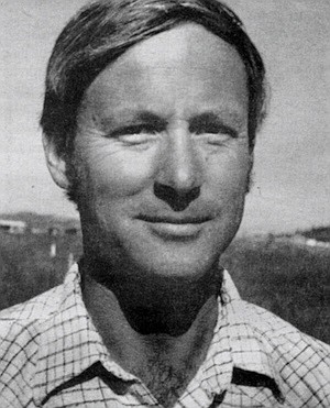
Remeika is a big, sturdy man, thirty-three years old, with light-brown hair that in places has been tinged blond by one of his passions: surfing. He grew up in Pacific Beach; like so many people native to San Diego County, who have long been preoccupied with avoiding the pitfalls of Los Angeles, he strives to be unpretentious. His speech is simple and honest, and he gives the appearance of being shy. But beneath this personality Remeika has the confidence and impeccable logic of a good scientist. An encyclopedic knowledge of local geology — he has a degree in the subject from San Diego State University — is one indication of his ability to tackle complex problems, and he sometimes talks with relish about the “detective work” that was necessary to locate parts of the old Butterfield route.
Our road crosses wash after desert wash, each one lined with a series of small ridges and gullies that send the station wagon bouncing up and down like a rodeo bull. The road during the 1850s was, if anything, probably worse, and we laugh about the arguments that must have taken place between passengers and drivers over the constant lurching of the stagecoaches. “I'm surprised there are no accounts of passengers shooting a driver,” Remeika observes wryly.
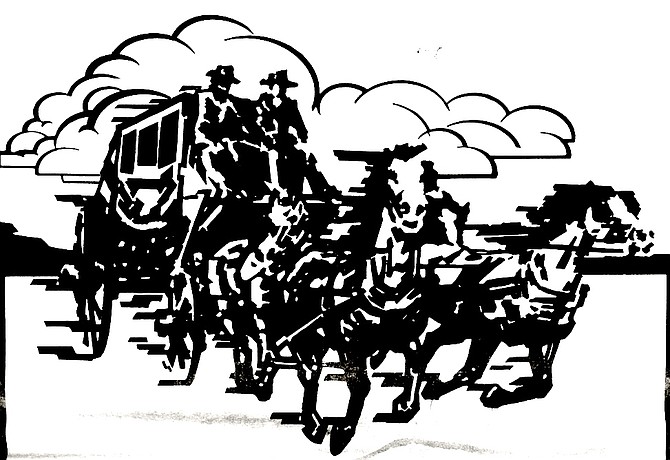
The classic Concord stagecoaches made famous by TV westerns were not used along this stretch of the Butterfield route. Instead, a smaller, lighter coach called a ‘‘mud wagon” was put into use. The mud wagons, about eight feet long and four feet wide, had canvas tops and four-foot-high spoked wooden wheels that facilitated crossing the deep sand and muddy stream bottoms of the western deserts. They held four to six people and had canvas or leather curtains on the outside to help keep out dust and the relentless sun. But these curtains worked only nominally, just as the vehicle’s “shock absorbers” — eight-inch-thick strips of rawhide on which the coach rested — did little to soften the bumps. Of a particularly rough stretch of road through the Ozark Mountains in Arkansas, Ormsby wrote: “Our heavy wagon bounded along the crags as if it would be shaken in pieces every minute, and ourselves disemboweled on the spot.” Two years after Ormsby’s trip, another passenger on the overland stage, the Englishman William Tallack, reported the coaches “often were unpleasantly and abruptly jerked down into streams, with much splashing and narrow escapes from oversets. . . . Hour after hour we were enveloped in clouds of fine clayey dust, as so many times previously and subsequently, when journeying over low-lying plains. What with the hot wind, the dust, and the perspiration, our faces and hands became covered with a thin mud.”
Under such circumstances, sleep would seem impossible, but Ormsby optimistically advised travelers that “as for sleeping . . . the jolting will be found disagreeable at first, but a few nights without sleep will obviate that difficulty. ... A bounce of the wagon, which makes one s head strike the top, bottom, or sides [of the coach], will be equally disregarded.” But not all passengers were as adaptable as Ormsby. Another correspondent wrote in 1860 that “the fatigue of uninterrupted traveling by day and night in a crowded coach, and in the most uncomfortable positions, was beginning to tell on all the passengers, and was producing in me a condition bordering on insanity. . . . Instances have occurred of travelers in this condition jumping from the coach, and wandering off to death from starvation in the desert.”
After miles of pitching and banging along the dirt road, we pull up next to a tall rusty signpost that looms improbably out of the desert scrub. We get out of the car to examine it, and can make out the faint legend “CARISO WATER 19 MILES.” Remeika smiles smugly. “This tells me this road is the old Butterfield road,” he says. James Jasper, former supervisor of San Diego County, traveled the Butterfield route in the 1890s and posted signs along it telling travelers how far it was to the nearest water. Although the Butterfield stagecoaches had long since vanished by then, the route was still a major thoroughfare for people traveling to and from California, and Jasper wanted to make their passage through the desert as safe as possible. Most of Jasper’s markers have disappeared, but Remeika learned about them from old pictures and accounts he found in the archives of the San Diego Historical Society at Balboa Park. One day a few months ago he came down this road out of the Carrizo Badlands and discovered three of Jasper’s markers still standing alongside the road. “I wasn’t even looking for them, but when I saw them I knew I was on the right trail,” he says.
In a few more miles we pass the flat-topped mountain, now looming like an ancient volcano to our left, and not long after that the road enters the Carrizo Impact Area, a former Navy bombing run closed to the public because of the large amounts of unexploded ordnance that litters the landscape. Remeika remarks that he has seen all manner of live bombs and shells in the impact area, and adds that one ranger came across a 500-pounder buried directly in the roadway with its nose sticking up a few inches out of the dirt. The Butterfield road exits the impact area in the middle of the wide, desolate Carrizo Wash, and then cuts straight across several miles of desert to the site of Carrizo station. From there it winds across creek beds and dunes, angling through some of the most rugged and inaccessible land in the county. This was part of Remeika’s patrol area for three years (he has since been assigned to work in the Palm Canyon campground in Borrego Springs), and he knows exactly where the road turns rocky and where to avoid steep gullies by blazing off into the brush. But even Remeika is surprised by one newly washed-out section; we come upon it suddenly, and we skid to a halt with our wheels just inches from a sheer four-foot drop that could have snapped the vehicle’s front axles like twigs.
We camp that night at Palm Spring, a tiny pool ringed by a thicket of mesquite and two scraggly palms. Historians have argued about whether the next Butterfield station after Carrizo was located at Palm Spring or nearby Mesquite Oasis, but Remeika found a photograph of the ruins of the old station that was taken in the 1930s. In the background of the photograph were a few barren hills, and one day Remeika went out to Palm Spring and matched the hills in the photograph with the hills just east of the spring. As the sun is setting, he shows me all that is left of Palm Spring station — a thick layer of powdered adobe, fine and soft as ash — and a nearby grave, a simple rectangle of rocks with a piece of splintered old wood resting inside. “I don’t know how old this grave is,” Remeika says solemnly, “but it’s old.” As darkness comes a half moon rises, glowing like a lamp behind a curtain of clouds; but much later in the night, long after we have gotten into our sleeping bags, the clouds dissipate and thousands of stars appear, bright and sharp as crystal. A meteorite burns a trail straight for the moon before fading out in the darkness.
Shivering in damp thirty-degree air the next morning, we gulp hot coffee and warm ourselves over a small fire. Then we are off on the Butterfield road again, which continues northwest from Palm Spring toward the restored Vallecito station. For a mile or so the route follows one of the park ’s many jeep roads and then gradually descends into a wash. The jeep road turns left and follows the course of the wash back toward S-2, but Remeika pauses on a high point above the wash and points to the far side. There, where no jeep has ever been, a faint path continues on through the cactus and creosote. In the vast desert plain around us the path is barely discernible, no more than a wide spot between bushes. Remeika notices me shaking my head. “From the air it's plain as day,” he says, almost apologetically. We hike across the wash to this section of the Butterfield road — one of the best preserved on the whole route — and stare silently at the tracks in the sand for a few moments. “You can almost hear the stages rattling through here,” Remeika says finally. “In August I walked this stretch in the summer heat, just to get a taste of what it must have been like back then. It was beautiful — dry and still. I only walked two miles back; it’s not a good idea to spend more than two hours away from your vehicle without water when it’s that hot. Well, it wasn’t that hot. About 112.” He chuckles. On that hike Remeika found a spoke from a wooden wagon wheel, a few square nails, and an old glass bottle, dark-colored from years of exposure to the desert sun. It would be hard to date these artifacts precisely, but they are clearly from the Nineteenth Century and indicate how untouched this section of the road is.
Thin gray clouds carpet the sky as we return to the station wagon and follow the jeep road to S-2. From here to Vallecito station the Butterfield trail twists in and out of Vallecito Wash, and many parts of it have been obliterated by flooding. Remeika has found the remaining sections, which lead like a dashed line straight to the station house. “Vallecito, or Little Valley, is a beautiful green spot — a perfect oasis in the desert,” wrote Ormsby. “It is about five miles square, surrounded by rugged timber-less hills, and the green bushes and grass and hard road are a most refreshing relief from the sandy sameness of the desert. There are a number of springs, some of them salty. There is but one ranch, where we changed horses.”
Vallecito station was restored in 1934 by the county; it is now surrounded by picnic tables, fire rings, and camper spaces that are in high demand on holiday weekends. Most of the station was rebuilt according to historical information, but three rooms at one end of the adobe-brick building are original. We enter through a low wooden doorway. The dark, dirt-floored room is filled with a musty scent — the scent of age.
The overland stage traveled night and day, but it did stop briefly at stations like Vallecito to change horses and let passengers eat a hurried meal, not usually of the gourmet variety. Beef, butter, and eggs were luxuries at desert stations, which were provisioned by local station-keepers employed by Butterfield. A more common dinner consisted of a piece of crumbly shortcake and a mug of brackish water. A few stations served coffee made by boiling the grounds directly in the water, cowboy style; one traveler described this brew as “strong enough to float a mule shoe.” A tea-like concoction known as “slumgullion” was also served occasionally. Mark Twain drank slumgullion on one of his many travels in the West, and called it “a pretense of tea, but there is too much sand and old bacon rind in it to deceive the intelligent traveler.”
Remeika and I wander a few hundred yards through the campground to a small cemetery where three graves are marked by rock cairns. Two of the three postdate the Butterfield era, and the third has no headstone; but Remeika says there is a legend in the area that the unmarked grave contains the body of a young woman who was on her way to San Francisco on the Butterfield stage to be married. Somewhere in the desert she came down with a fever, and by the time the stage reached Vallecito station she was deliriously ill. That night the desert wind blew mercilessly, and in a dark room lit by flickering candles, the young woman died. The next morning she was buried near the station in her wedding gown.
It was also near Vallecito that five men on horseback once tried to rob the stage. According to an account that Bill Smith, a former stage driver, told to James Jasper (the former county supervisor) in 1888, there were three passengers on board, all armed with pistols and rifles. When the bandits attacked they were greeted by blazing guns from inside the coach. The driver whipped his mules full-speed along the road toward the station, but all at once the gunfire claimed the life of one of the animals. The mule dropped in its tracks, overturning the stage. The bandits came in, firing at close range, and killed one of the passengers before being driven off by a group of soldiers stationed at nearby Vallecito. The coach was righted and continued on to the safety of the station house while the soldiers rode off after the would-be robbers. In the middle of the night the soldiers returned. Asked what had happened to the bandits, the corporal in charge replied curtly, “Vallecito has no accommodations for prisoners.” No further questions were asked.
One of the stage drivers who worked out of Vallecito station was John McCain. McCain homesteaded land near the station site along with his three brothers, and a member of the McCain family still lives on that land, almost within shouting distance of the restored station house. The family has sold 165 acres of their original 640-acre section, and there are no cattle grazing on the property as there were in 1858, but other than that the parcel has changed little. George McCain lives by himself in an old Airstream trailer beneath a eucalyptus tree, about half a mile from S-2, and after leaving Vallecito station Remeika and I drive up and bang on the trailer s door. McCain, a big, stocky man of sixty-seven, welcomes us inside, motions us into a worn couch, and plunks down in a nearby chair. A Colt .45 hangs in a holster on the wall behind his head, and above it is a yellowed photograph showing a buckboard wagon drawn by two huge oxen. George McCain’s grandfather is seated in the wagon, and there is another man standing nearby in a white shirt and a cowboy hat — his grandfather's brother, John McCain.
McCain tells us that his stage-driving great-uncle owned a hotel in Julian in his later years with a stagecoach parked out in front. Other than that he remembers little of John McCain, who died when George was only eleven. But after rummaging around through some old papers, McCain finds a book with some biographical information about his ancestor. A large, powerful man, John McCain was said to have been able to grab a fifty-pound sack of flour and hoist it up onto his saddle while riding by at full speed on horseback. He was just seventeen years old when he became a driver for the Butterfield stage. “In those days they didn’t go to school, they went out and went right to work,” George McCain declares proudly.
McCain himself went to work right out of high school, and like his great-uncle before him, his first job was on the local transportation network. California was growing more rapidly by then, and the younger McCain worked as a laborer on local roads for the state highway department. After serving in England during World War II he returned to Vallecito and worked for various construction companies, operating heavy machinery. He is now retired.
Remeika asks if he knows the location of the original Butterfield route in this area, and McCain replies evenly, “I can tell you everywhere it goes between here and Scissors Crossing [about fifteen miles to the north]. We used to look for it every time we drove by it — my old man knew where it was.” The nearest section is easy enough to find, he explains; it crosses his property a few feet from S-2, and he has marked the trail with a piece of granite turned on its end.
McCain describes the location of the route in detail while Remeika takes notes; later the notes will confirm Remeika s own observations. As we rise to go, McCain mentions that all of his 475 acres is currently for sale. “It’s costing me more money in taxes than it’s worth,” he complains. “The wind blows just about all the time, and when it isn’t hotter than hell it’s colder than hell.” But a moment later he adds, “Some guy is going to have to come up with a suitcase full of money [to buy it) or the hell with 'em. I'll stay here.” He turns to look at the scrub-covered plain outside, sloping up toward the Laguna Mountains. “I've been thinking about putting up some fence and running some cows in here,” he remarks. “All that feed is going to waste.”
A few miles north of Vallecito station the Butterfield road enters Box Canyon, a narrow gorge that knifes through a steep mountain ridge. With its sheer sides thirty feet high, the gorge in 1858 presented the only possible route through this part of the desert. But as its name implies. Box Canyon dead ends about halfway through the ridge in a smooth wall of solid rock some twenty feet high. To get past this barrier, the Butterfield company built a trail that leads precariously up the canyon’s sides and around the rock wall; it rejoins the upper part of the canyon a few hundred yards farther on. The big round stones stacked by laborers to buttress the trail are still in place, and the route itself is commemorated here by a state historical marker.
Ormsby, writing in 1858, described Box Canyon as “a very narrow pass — the most wonderful on the route. It appears to have been the bed of a fierce torrent, but it was now dry. The channel appears to have been cut through the solid rocks with the regularity of a deep cut for a railroad, and perpendicularly up the steep sides of the narrow pass the jagged rocks tower, apparently ready to fall and crush all beneath them. . . . Our progress through this portion of the road was quite slow, necessarily, and it required all Mr. Hall's skill to guide our team and wagon safely through the pass; for in some places there was hardly an inch to spare. It is the most wonderful natural road I ever saw or heard of.”
During the time when the stages were still running, the mouth of Box Canyon was the junction for the Lassator hay road, a narrow, steep, thoroughly dangerous and half-crazy trail that led almost directly up the green wall of the Laguna Mountains. In 1857 James R. Lassator, a rancher with property at Vallecito and at Green Valley (in the Cuyamaca Mountains), contracted Indian and Mexican laborers to clear the brush and rocks along this trail by hand. San Diego-bound mail and passengers on the Butterfield stage sometimes transferred to mule-back at the hay road and rode eighteen miles up into the mountains to Lassator s place in Green Valley. There the passengers were fed and lodged, and the next day they boarded stagecoaches that carried them down the current route of Interstate 8, through El Cajon to San Diego. Lassator also used the road to supply stage stations in the area with provisions and hay grown at his mountain ranch. Remeika tells me the hay was carried to the brink of the steep trail in wagons; there the wheels were removed and the wagons were slid some 3000 feet down the hay ‘Toad" to the Butterfield trail, no doubt accompanied by much cursing and shouting. "How Lassator got the wagons back up, I don’t know,” Remeika says. "Maybe he sold them for firewood.”
Remeika knows just how steep the hay road is because he hiked it last June with fellow ranger Tom McBride. Sensibly, the two of them began at the top (the road begins on the Sunrise Highway near Lake Cuyamaca) and climbed downward. McBride said recently that the two-and-a-half-mile-long route was steep enough to make him wonder how any vehicles ever traversed it. The road was also overgrown with brush, McBride noted. “You couldn't see it until you were right on it. I had driven right by it for five years without ever seeing it, and I had looked for it. But Paul kept bugging me to find the exact route, and we finally did. Paul has a lot of enthusiasm about what he does.”
“I don’t know what it is that has kept me so interested in this project,” Remeika mused not long ago. “Back in 1967 my parents took me to Yellowstone, the Grand Tetons, and the Black Hills of South Dakota; that’s when I first got interested in the [pioneer era]. Here in San Diego there’s so little information on that era. . . . Maybe I wanted to learn all I could. Maybe being into geology helped, too, because out here [in the desert] you run across ancient landscapes that are still intact. And those are millions of years old. The Butterfield road is only 120 years old. Hell, that’s recent. He shrugged. “The day George showed me what was left of the stage trail in that one place, something in my mind just clicked.”
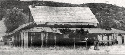
From Box Canyon the Butterfield road crosses a dry lake bed, climbs over a low pass, and then curves across Earthquake Valley to Highway 78 and Scissors Crossing. San Felipe stage station — the next station after Vallecito — once stood a few hundred yards north of Highway 78, and its foundation can still be found in the privately owned cattle pasture that now sprawls across the site. The stage road itself continues northward up the western side of the San Felipe Valley (well away from S-2, which hugs the eastern side), climbing steadily to the site of Warner’s Ranch. The ranch house there once served as yet another stage station, and its sagging ruins still stand on county road S-22 a few miles south of the town of Warner Springs. “Warner's Ranch is a comfortable house,” wrote Ormsby, “situated in the valley, in the midst of a beautiful meadow, and with its shingled roof looked more like civilization than anything I had seen for many days.”
Warner’s ranch is the northernmost point in the county to which Remeika has been able to trace the original track of the Butterfield stage. But now that he works at a campground in nearby Borrego Springs he is hoping to search for remnants of the road that might still exist between Warner Springs and Temecula. One frosty morning in late December we meet at the site of Warner's ranch house and drive up Highway 79 toward Aguanga, just across the Riverside County line. When Ormsby's stage first passed through this area, there was a young man riding shotgun on it named Jacob Bergman, who eventually settled in I Aguanga and raised cattle and sheep there. Many of Bergman’s descendants have remained in the area, and we have made arrangements to talk with one of them, Esther Bergman Trunnell, who knows something about the family history.
The road passes through a series of small communities: Warner Springs, Sunshine Summit, Oak Grove. In each one there is some commercial establishment boasting of the Butter-Field name, including the Stage Trail Inn and the Butterfield Cafe. One gas station even features a battered old stagecoach in front that has been painted a garish yellow. Butterfield's stages stopped running through here in 1861, but 122 years later they are still the biggest thing that ever happened in this part of the county. The stage route was brought to an end by the Civil War, which made travel through the Confederate states of Texas and Arkansas to Union-supporting California impossible. Within a few months Butterfield’s employees had transferred horses, mules, coaches, and other equipment northward to a new route that ran from St. Louis to Salt Lake City and San Francisco without passing through Confederate territory. Ironically, this route was the one the postal service had originally rejected because it would tie closed by snow during the winter. But the stage drivers found it workable enough, and so did the railroads when they finally linked the coasts by rail in 1869. The trains rendered the overland stage obsolete virtually overnight, and soon replaced stagecoaches all over the West as the symbol of power and expansion. The original Butterfield route through eastern San Diego County was still being used by emigrants in wagons and on horseback until the early 1900s, but by then it was only one of many paths for the people streaming into California.
Remeika and I pull up in front of the Trunnell house in Aguanga, where Esther Trunnell, a short, matronly woman with an eager smile, greets us at the front door. As we drive to a small family cemetery nearby she informs us that there is no concrete proof that her great-grandfather Jacob Bergman ever rode on the Butterfield stage. No historical account mentions him, and his name does not appear in the lists of Butterfield employees that have been preserved from that era. But Trunnell points out that Jacob Bergman is known to have been in the area prior to 1858 and drove stages for a later mail route, and the legend persists that he was riding on Ormsby's coach, too.
The cemetery sits in a field overgrown with weeds, gray and brittle now at the end of the year. A large headstone marks the grave of Jacob Bergman, 1832-1894, and next to it lies a smaller stone commemorating his wife Philipena. Trunnell points to a small wooden house on the other side of the valley; it is all that is left of her great-grandfathers ranch house, she says, which once served as a stage station. “I’ve been thinking a lot about what the valley must have looked like back then,” she adds. “It must have been beautiful, and green. . . . There weren't many people out here then.”
Whatever it was those hardy travelers on the Butterfield stage were seeking in California — gold, fame, the promise of sunshine over a green valley — they stayed. As Ormsby predicted, the stage line contributed significantly to the development of the West. Towns grew along its route, businesses and governments were established, money changed hands. In a way they are still coming, those settlers; by jet and highway now, still looking to strike it rich in bountiful California. “Living your life the California way,” sums up a current bank jingle with unexpected insight, “opportunity every day.” To the rest of the nation, California was and is a dream zone, a place where American enterprise can be speedily rewarded. There are other such places, of course, but California is the largest and most varied among them, and in a very concrete way the state continues to attract people with the drive and independence and irascibility of the pioneers.
We get back into the car and drive a few miles north, to a place where Trunnell's uncle once showed her a groove in a granite boulder. The groove, he told her, was shown to him by his grandfather, and was made by the countless wheels of wagons and stagecoaches as they rolled into California on the Butterfield route. “If not for my interest, this old track would have disappeared forever, because, as far as I know, not even mother or Aunt Harriet knew of it,” Trunnell says.
When we arrive at the stop, we get out of the car and follow Trunnell into thick dry brush near the side of the road. She goes straight to a broad boulder, but she has not been to the site for years and for a few moments, despite bending branches and digging with her shoe, she cannot find the groove. But suddenly she calls out, “Here! Here it is!” and points to a mossy indentation one inch deep and about eighteen inches long. Remeika leans over, peering intently at the mark. The day Ormsby arrived in San Francisco on the first Butterfield stagecoach a local newspaper noted, “It is difficult at this moment to realize the full importance to the Pacific coast of the establishment of overland mail routes. We will cease to be considered any longer a distant dependency — a colony, as it were. We now enter the family of States, and are socially and politically part and parcel of the Union.”
Here's something you might be interested in.
Indians, dust, and death along the old Butterfield Overland Stage route
Notes from a wagon seat
Indians, dust, and death along the old Butterfield Overland Stage route
Notes from a wagon seat
The stage route was brought to an end by the Civil War, which made travel through the Confederate states of Texas and Arkansas to Union-supporting California impossible.
Waterman Lily Ormsby pulled into Carrizo station in the early morning hours of October 6. He was not impressed with what he found. There was almost nothing to eat at the crude adobe hut that served as a station house, and the little water that was available tasted of sulfur and salt. Looking around at the low sand hills that surrounded the station, barren except for creosote bushes and twisted, thorny mesquite, Ormsby must have sighed.
Butterfield route near Vallecito station. From S-2 to Vallecito station the Butterfield trail twists in and out of Vallecito Wash, and many parts of it have been obliterated by flooding.
He had just come more than 2000 miles in a stagecoach that had rolled out of Tipton, Missouri some nineteen days and fourteen hours earlier. The coach had jounced roughly over every stone and furrow along the road, and rattled Ormsby’s head against its wooden sides whenever he tried to sleep. For the last two days, since leaving Yuma, the horses had dragged the coach through the heavy sand of the Colorado Desert — sand so deep that Ormsby often had to get out and walk until the road became harder and more passable.
Butterfield stage route. More often the stage trail can be found winding through the desert on either side of S-2, and in several places it swings well away from the paved road.
Then, as the stage neared Carrizo station, it passed a large group of cattle that had been abandoned by a recent wagon train because the animals were too weak to travel. “There they stood," Ormsby wrote later, “almost living skeletons, gradually dying of thirst with water within a few miles of them. I could almost imagine they looked supplicatingly at us, and begged for just one single drop. Some were standing, other lying, and others just gasping in the agonies of death — a sight almost enough to sicken the stoutest heart.”
Butterfield stage station at Warner's Ranch, c. 1938. The ranch is the northernmost point in the county to which Remeika has been able to trace the original track of the Butterfield stage.
After all this, Carrizo station, with its bleak setting and god-awful water, must have been a mite disappointing. And Ormsby still had more than 700 miles to go. He was traveling on the Butterfield Overland Stage, which carried mail and passengers from Missouri to San Francisco 125 years ago. Ormsby, a special correspondent for the New York Herald, rode on the first stage to cover the route, and periodically sent accounts of his journey back to New York for all the world to read. The new mail route established a regular land connection between California and the eastern United States for the first time, and Ormsby and his editors at the Herald had the foresight to realize it would be a major factor in the development of the West.
Remeika returned to the spot later that same afternoon and sat in his jeep, staring at the trail. Slowly it sank in: In the dry desert air the 125-year-old road had been preserved in virtually pristine condition. “I couldn't believe it."
Carrizo station (located a few miles east of county road S-2, in Anza-Borrego Desert State Park) has long since turned to dust; all that exists of it today is a layer of stone and charcoal, the remnants of the old station floor. Even the countryside around it has changed. As Paul Remeika and I stand on a hill overlooking the station site we can see thick stands of tamarisk that have invaded Carrizo Creek since Ormsby's time, their wispy tops a beautiful orange-gold now, in early December.
Restored stagecoach. The classic Concord stagecoaches made famous by TV westerns were not used along this stretch of the Butterfield route. Instead, a smaller, lighter coach called a ‘‘mud wagon” was put into use.
Abundant water shines in the creek bed after a summer of heavy rains. But the surrounding terrain is still covered with creosote and mesquite and little else; and the track of the stage itself is still visible, a tan line leading straight as a light beam out of the arid wilderness to the east. “When you see the route sitting there like that, plain as day, it’s enough to send shivers up your spine,” Remeika says.
Restored stagecoach, Old Town State Park. The coach had jounced roughly over every stone and furrow along the road, and rattled Ormsby’s head against its wooden sides whenever he tried to sleep.
Remeika is a state park ranger in Anza-Borrego Desert State Park. Three years ago he was assigned to patrol the vast, remote southern third of the park, an area of 163,000 acres located between State Highway 78 in the north and Interstate 8 in the south. It is a sparsely populated area — the largest communities in it, Ocotillo,
Vallecito station was restored in 1934 by the county; it is now surrounded by picnic tables, fire rings, and camper spaces that are in high demand on holiday weekends.
Shelter Valley, and Canebrake, are no more than small clusters of houses and trailers — and it contains but a single paved road, county road S-2. It didn't take Remeika long to learn that the stage route had once passed through this area; commercial establishments along S-2 trade heavily on the Butterfield era. Twelve miles south of Highway 78 is a trailer park and campground called the Butterfield Ranch, and a few miles south of that lies the restored Vallecito stage station, now a county park. Route S-2 itself is marked impressively with signs that read “Great Southern Overland Mail Route of 1849." But Remeika assumed the stage trail itself had long since disappeared beneath blacktop, blowing sand, and the innumerable tracks of cattle and off-road vehicles. Most of the old-timers who live in the area told him exactly that — that the stage road had been obliterated years ago.
But in June of this year Remeika was out in a nameless desert wash with George Miller, a long-time resident of Canebrake who teaches paleontology at Imperial Valley College in nearby Brawley. After half a day spent searching for fossils. Miller and Remeika were driving back to S-2 when Miller pointed to a faint path through the desert scrub and casually remarked that it was the track of the Butterfield stage. Remeika returned to the spot later that same afternoon and sat in his jeep, staring at the trail. Slowly it sank in: In the dry desert air the 125-year-old road had been preserved in virtually pristine condition. “I couldn't believe it," he recalls. “I kept thinking, ‘Damn! It's still here!' “
Since that day Remeika has been obsessed with tracing the remnants of the stage road through San Diego County. He contacted long-time residents along S-2, some of them people whose forefathers homesteaded the area; a few of them knew where sections of the original Butterfield road lay. He ferreted out old accounts and photographs of the route from obscure libraries and collections all over the county, and used them to find remote sections of the trail that many people considered lost. Remeika hiked those sections, and then flew over them from the air with a fellow ranger, Tom McBride, to see where they might connect to other sections that couldn’t be detected from the ground.
After six months of research, Remeika knows more about the location of the original Butterfield stage route than anyone else in the county. And he has learned to regard the signs marked “Great Southern Overland Stage Route of 1849“ with amusement. There are two things wrong with those signs: they do not mark the precise route of the Butterfield Overland Stage, and the company itself did not exist in 1849. Butterfield’s stages rattled across San Diego County from 1858 to 1861, and S-2 follows their original route only sporadically and for short distances. More often the stage trail can be found winding through the desert on either side of S-2, and in several places it swings well away from the paved road. In some locations the trail has been washed out by seasonal flooding; in other places it serves as a jeep road for park visitors who probably are unaware of the history beneath their wheels. A few sections have been obliterated completely and others have been preserved remarkably well. Like a child solving a connect-the-dots puzzle, Remeika discovered section after section of the old stage road, linked them together, and plotted them on topographic maps. The trail on which thousands of people first entered California and drifted into San Diego runs through modem housing developments as well as some of the most barren wilderness the county can offer. And one day last December Remeika and I met to follow it from start to finish.
Plaster City, a few miles west of El Centro, is a staggering misnomer: the “city” consists of a few parking lots that surround a gypsum-refining plant. The sun hangs in a cloudless blue sky as Remeika and I, riding in a four-wheel-drive station wagon, bounce up to a wide, shallow pit about one mile northeast of the plant. Remeika has traced the Butterfield trail eastward to this point, but no farther; beyond the pit the old stage road was washed away in the early part of this century by the flooding of the Colorado River. But here amid countless scars left by off-road vehicles a dirt road leads westward toward the Carrizo Badlands. Covered with the tracks of motorcycles and jeeps, it is the route of the Butterfield Stage.
We leave the shallow pit, pass under a railroad bridge, and drive into the deep sand of Coyote Wash. The sky overhead is split by screaming Navy jets on their way to a bombing run in a nearby target area. “We’re going to be out in the middle of nowhere for most of the day,” Remeika says with a little grin. In the distance, shimmering in the late morning heat waves, we can see a strange, flat-topped mountain with deeply eroded sides. For the next few hours it will be a landmark for navigating our proper course, as it was for the drivers of the Butterfield stage.
John Butterfield, a wealthy New Yorker and the founder of the American Express Company, was awarded the lucrative contract for the overland mail by the United States Postal Service in 1857. For the sum of $600,000 a year he agreed to put together a stage line that would carry mail from Missouri to San Francisco in twenty-five days or less. The gold rush of 1849 had caused California's population to swell dramatically, and reliable mail delivery was one of many badly needed government services in the new state. But Butterfield was rumored to have obtained the contract on the strength of his friendship with President James Buchanan, and the Chicago Tribune denounced the mail agreement as “one of the greatest swindles ever perpetrated.” It was later demonstrated that it cost the government between thirty-five and sixty dollars to transport a single letter via the overland stage. But there were political reasons for setting up the mail route as well, not the least of which was strengthening American presence in the vast Southwest, a region formerly dominated by Indians and natives of unfriendly Mexico.
The postal service at first considered a route that ran from St. Louis to Salt Lake City and on to Sacramento and San Francisco, but rejected it because of the heavy snows that were certain to close the route for months where it crossed the Rocky and Sierra Nevada mountains. And so a route was chosen that led from Tipton, Missouri through Arkansas, Texas, New Mexico, Arizona, and then northward through eastern San Diego County, a route that was open year 'round. Explorers, U.S. Army troops, and a trickle of emigrants had been using it for decades. Butterfield invested nearly one million dollars to develop stage facilities along this route; 139 stations were built, 1200 horses and 600 mules were transported to them, one hundred stagecoaches were ordered. The 2800-mile, 540-hour trip between Tipton and San Francisco became the longest stage ride in the world.
When the first coach left Tipton on September 16, 1858, few people realized the significance the stage line would have on the eventual settlement of California and the West. One of the few was waterman Lily Ormsby. A dapper man with a bushy black mustache, the twenty-three-year-old Ormsby, a resident of New York City at the time, thoroughly scooped his fellow journalists by being the only passenger to book passage for the full route on the first stage westward. As a writer Ormsby had a penchant for pedantic details; his account is full of mileages and arrival and departure times at the newly built stage stations. He was also quick to pick up the prejudices of his time, writing of “bloodthirsty Indians" and “greasy-looking Mexicans.” But he had a perceptive eye and the good sense to realize how significant the stage route would be to the future of the United States. “The importance of an enterprise which is the first practical step towards the Pacific railroad can hardly be overrated,’ ’ he noted. “If the overland mail succeeds, the railroad and telegraph will soon follow its course; the settlements along the line will be built up with rapidity, and our vast possessions [in the West] will be opened up to us and the world....”
From Yuma the overland trail led twelve miles westward into California, dipped into Mexico to skirt the great Algodones sand dunes, and recrossed the border near modern-day Calexico. From there it slanted northwest across a barren plain now covered with lush fields of sugar beets, heading for one of the company’s way stations called Indian Wells. “Twenty-four miles of heavy sand riding brought us to the Indian Wells, where we found the station men had [recently had] some difficulty with Indians, who refused to let them have water for their animals,” Ormsby wrote. “Almost a collision ensued, but the Indians finally retired without making an attack, although they were vastly in the majority.”
Indian Wells station, which stood on the north bank of Coyote Wash near Plaster City, has been completely destroyed by flooding. But Paul Remeika learned that the map coordinates for it had been published in a recent federal archeological survey of the area; and after being told by one of the survey’s coordinators that the site was marked by a tamarisk tree, he went out and located the tree. Remeika points to it as we careen by it in the deep sand of the wash: it is the only tree visible for a long way in any direction. A few hundred yards farther on we climb steeply out of the wash and set off toward the flat-topped mountain.
Remeika is a big, sturdy man, thirty-three years old, with light-brown hair that in places has been tinged blond by one of his passions: surfing. He grew up in Pacific Beach; like so many people native to San Diego County, who have long been preoccupied with avoiding the pitfalls of Los Angeles, he strives to be unpretentious. His speech is simple and honest, and he gives the appearance of being shy. But beneath this personality Remeika has the confidence and impeccable logic of a good scientist. An encyclopedic knowledge of local geology — he has a degree in the subject from San Diego State University — is one indication of his ability to tackle complex problems, and he sometimes talks with relish about the “detective work” that was necessary to locate parts of the old Butterfield route.
Our road crosses wash after desert wash, each one lined with a series of small ridges and gullies that send the station wagon bouncing up and down like a rodeo bull. The road during the 1850s was, if anything, probably worse, and we laugh about the arguments that must have taken place between passengers and drivers over the constant lurching of the stagecoaches. “I'm surprised there are no accounts of passengers shooting a driver,” Remeika observes wryly.
The classic Concord stagecoaches made famous by TV westerns were not used along this stretch of the Butterfield route. Instead, a smaller, lighter coach called a ‘‘mud wagon” was put into use. The mud wagons, about eight feet long and four feet wide, had canvas tops and four-foot-high spoked wooden wheels that facilitated crossing the deep sand and muddy stream bottoms of the western deserts. They held four to six people and had canvas or leather curtains on the outside to help keep out dust and the relentless sun. But these curtains worked only nominally, just as the vehicle’s “shock absorbers” — eight-inch-thick strips of rawhide on which the coach rested — did little to soften the bumps. Of a particularly rough stretch of road through the Ozark Mountains in Arkansas, Ormsby wrote: “Our heavy wagon bounded along the crags as if it would be shaken in pieces every minute, and ourselves disemboweled on the spot.” Two years after Ormsby’s trip, another passenger on the overland stage, the Englishman William Tallack, reported the coaches “often were unpleasantly and abruptly jerked down into streams, with much splashing and narrow escapes from oversets. . . . Hour after hour we were enveloped in clouds of fine clayey dust, as so many times previously and subsequently, when journeying over low-lying plains. What with the hot wind, the dust, and the perspiration, our faces and hands became covered with a thin mud.”
Under such circumstances, sleep would seem impossible, but Ormsby optimistically advised travelers that “as for sleeping . . . the jolting will be found disagreeable at first, but a few nights without sleep will obviate that difficulty. ... A bounce of the wagon, which makes one s head strike the top, bottom, or sides [of the coach], will be equally disregarded.” But not all passengers were as adaptable as Ormsby. Another correspondent wrote in 1860 that “the fatigue of uninterrupted traveling by day and night in a crowded coach, and in the most uncomfortable positions, was beginning to tell on all the passengers, and was producing in me a condition bordering on insanity. . . . Instances have occurred of travelers in this condition jumping from the coach, and wandering off to death from starvation in the desert.”
After miles of pitching and banging along the dirt road, we pull up next to a tall rusty signpost that looms improbably out of the desert scrub. We get out of the car to examine it, and can make out the faint legend “CARISO WATER 19 MILES.” Remeika smiles smugly. “This tells me this road is the old Butterfield road,” he says. James Jasper, former supervisor of San Diego County, traveled the Butterfield route in the 1890s and posted signs along it telling travelers how far it was to the nearest water. Although the Butterfield stagecoaches had long since vanished by then, the route was still a major thoroughfare for people traveling to and from California, and Jasper wanted to make their passage through the desert as safe as possible. Most of Jasper’s markers have disappeared, but Remeika learned about them from old pictures and accounts he found in the archives of the San Diego Historical Society at Balboa Park. One day a few months ago he came down this road out of the Carrizo Badlands and discovered three of Jasper’s markers still standing alongside the road. “I wasn’t even looking for them, but when I saw them I knew I was on the right trail,” he says.
In a few more miles we pass the flat-topped mountain, now looming like an ancient volcano to our left, and not long after that the road enters the Carrizo Impact Area, a former Navy bombing run closed to the public because of the large amounts of unexploded ordnance that litters the landscape. Remeika remarks that he has seen all manner of live bombs and shells in the impact area, and adds that one ranger came across a 500-pounder buried directly in the roadway with its nose sticking up a few inches out of the dirt. The Butterfield road exits the impact area in the middle of the wide, desolate Carrizo Wash, and then cuts straight across several miles of desert to the site of Carrizo station. From there it winds across creek beds and dunes, angling through some of the most rugged and inaccessible land in the county. This was part of Remeika’s patrol area for three years (he has since been assigned to work in the Palm Canyon campground in Borrego Springs), and he knows exactly where the road turns rocky and where to avoid steep gullies by blazing off into the brush. But even Remeika is surprised by one newly washed-out section; we come upon it suddenly, and we skid to a halt with our wheels just inches from a sheer four-foot drop that could have snapped the vehicle’s front axles like twigs.
We camp that night at Palm Spring, a tiny pool ringed by a thicket of mesquite and two scraggly palms. Historians have argued about whether the next Butterfield station after Carrizo was located at Palm Spring or nearby Mesquite Oasis, but Remeika found a photograph of the ruins of the old station that was taken in the 1930s. In the background of the photograph were a few barren hills, and one day Remeika went out to Palm Spring and matched the hills in the photograph with the hills just east of the spring. As the sun is setting, he shows me all that is left of Palm Spring station — a thick layer of powdered adobe, fine and soft as ash — and a nearby grave, a simple rectangle of rocks with a piece of splintered old wood resting inside. “I don’t know how old this grave is,” Remeika says solemnly, “but it’s old.” As darkness comes a half moon rises, glowing like a lamp behind a curtain of clouds; but much later in the night, long after we have gotten into our sleeping bags, the clouds dissipate and thousands of stars appear, bright and sharp as crystal. A meteorite burns a trail straight for the moon before fading out in the darkness.
Shivering in damp thirty-degree air the next morning, we gulp hot coffee and warm ourselves over a small fire. Then we are off on the Butterfield road again, which continues northwest from Palm Spring toward the restored Vallecito station. For a mile or so the route follows one of the park ’s many jeep roads and then gradually descends into a wash. The jeep road turns left and follows the course of the wash back toward S-2, but Remeika pauses on a high point above the wash and points to the far side. There, where no jeep has ever been, a faint path continues on through the cactus and creosote. In the vast desert plain around us the path is barely discernible, no more than a wide spot between bushes. Remeika notices me shaking my head. “From the air it's plain as day,” he says, almost apologetically. We hike across the wash to this section of the Butterfield road — one of the best preserved on the whole route — and stare silently at the tracks in the sand for a few moments. “You can almost hear the stages rattling through here,” Remeika says finally. “In August I walked this stretch in the summer heat, just to get a taste of what it must have been like back then. It was beautiful — dry and still. I only walked two miles back; it’s not a good idea to spend more than two hours away from your vehicle without water when it’s that hot. Well, it wasn’t that hot. About 112.” He chuckles. On that hike Remeika found a spoke from a wooden wagon wheel, a few square nails, and an old glass bottle, dark-colored from years of exposure to the desert sun. It would be hard to date these artifacts precisely, but they are clearly from the Nineteenth Century and indicate how untouched this section of the road is.
Thin gray clouds carpet the sky as we return to the station wagon and follow the jeep road to S-2. From here to Vallecito station the Butterfield trail twists in and out of Vallecito Wash, and many parts of it have been obliterated by flooding. Remeika has found the remaining sections, which lead like a dashed line straight to the station house. “Vallecito, or Little Valley, is a beautiful green spot — a perfect oasis in the desert,” wrote Ormsby. “It is about five miles square, surrounded by rugged timber-less hills, and the green bushes and grass and hard road are a most refreshing relief from the sandy sameness of the desert. There are a number of springs, some of them salty. There is but one ranch, where we changed horses.”
Vallecito station was restored in 1934 by the county; it is now surrounded by picnic tables, fire rings, and camper spaces that are in high demand on holiday weekends. Most of the station was rebuilt according to historical information, but three rooms at one end of the adobe-brick building are original. We enter through a low wooden doorway. The dark, dirt-floored room is filled with a musty scent — the scent of age.
The overland stage traveled night and day, but it did stop briefly at stations like Vallecito to change horses and let passengers eat a hurried meal, not usually of the gourmet variety. Beef, butter, and eggs were luxuries at desert stations, which were provisioned by local station-keepers employed by Butterfield. A more common dinner consisted of a piece of crumbly shortcake and a mug of brackish water. A few stations served coffee made by boiling the grounds directly in the water, cowboy style; one traveler described this brew as “strong enough to float a mule shoe.” A tea-like concoction known as “slumgullion” was also served occasionally. Mark Twain drank slumgullion on one of his many travels in the West, and called it “a pretense of tea, but there is too much sand and old bacon rind in it to deceive the intelligent traveler.”
Remeika and I wander a few hundred yards through the campground to a small cemetery where three graves are marked by rock cairns. Two of the three postdate the Butterfield era, and the third has no headstone; but Remeika says there is a legend in the area that the unmarked grave contains the body of a young woman who was on her way to San Francisco on the Butterfield stage to be married. Somewhere in the desert she came down with a fever, and by the time the stage reached Vallecito station she was deliriously ill. That night the desert wind blew mercilessly, and in a dark room lit by flickering candles, the young woman died. The next morning she was buried near the station in her wedding gown.
It was also near Vallecito that five men on horseback once tried to rob the stage. According to an account that Bill Smith, a former stage driver, told to James Jasper (the former county supervisor) in 1888, there were three passengers on board, all armed with pistols and rifles. When the bandits attacked they were greeted by blazing guns from inside the coach. The driver whipped his mules full-speed along the road toward the station, but all at once the gunfire claimed the life of one of the animals. The mule dropped in its tracks, overturning the stage. The bandits came in, firing at close range, and killed one of the passengers before being driven off by a group of soldiers stationed at nearby Vallecito. The coach was righted and continued on to the safety of the station house while the soldiers rode off after the would-be robbers. In the middle of the night the soldiers returned. Asked what had happened to the bandits, the corporal in charge replied curtly, “Vallecito has no accommodations for prisoners.” No further questions were asked.
One of the stage drivers who worked out of Vallecito station was John McCain. McCain homesteaded land near the station site along with his three brothers, and a member of the McCain family still lives on that land, almost within shouting distance of the restored station house. The family has sold 165 acres of their original 640-acre section, and there are no cattle grazing on the property as there were in 1858, but other than that the parcel has changed little. George McCain lives by himself in an old Airstream trailer beneath a eucalyptus tree, about half a mile from S-2, and after leaving Vallecito station Remeika and I drive up and bang on the trailer s door. McCain, a big, stocky man of sixty-seven, welcomes us inside, motions us into a worn couch, and plunks down in a nearby chair. A Colt .45 hangs in a holster on the wall behind his head, and above it is a yellowed photograph showing a buckboard wagon drawn by two huge oxen. George McCain’s grandfather is seated in the wagon, and there is another man standing nearby in a white shirt and a cowboy hat — his grandfather's brother, John McCain.
McCain tells us that his stage-driving great-uncle owned a hotel in Julian in his later years with a stagecoach parked out in front. Other than that he remembers little of John McCain, who died when George was only eleven. But after rummaging around through some old papers, McCain finds a book with some biographical information about his ancestor. A large, powerful man, John McCain was said to have been able to grab a fifty-pound sack of flour and hoist it up onto his saddle while riding by at full speed on horseback. He was just seventeen years old when he became a driver for the Butterfield stage. “In those days they didn’t go to school, they went out and went right to work,” George McCain declares proudly.
McCain himself went to work right out of high school, and like his great-uncle before him, his first job was on the local transportation network. California was growing more rapidly by then, and the younger McCain worked as a laborer on local roads for the state highway department. After serving in England during World War II he returned to Vallecito and worked for various construction companies, operating heavy machinery. He is now retired.
Remeika asks if he knows the location of the original Butterfield route in this area, and McCain replies evenly, “I can tell you everywhere it goes between here and Scissors Crossing [about fifteen miles to the north]. We used to look for it every time we drove by it — my old man knew where it was.” The nearest section is easy enough to find, he explains; it crosses his property a few feet from S-2, and he has marked the trail with a piece of granite turned on its end.
McCain describes the location of the route in detail while Remeika takes notes; later the notes will confirm Remeika s own observations. As we rise to go, McCain mentions that all of his 475 acres is currently for sale. “It’s costing me more money in taxes than it’s worth,” he complains. “The wind blows just about all the time, and when it isn’t hotter than hell it’s colder than hell.” But a moment later he adds, “Some guy is going to have to come up with a suitcase full of money [to buy it) or the hell with 'em. I'll stay here.” He turns to look at the scrub-covered plain outside, sloping up toward the Laguna Mountains. “I've been thinking about putting up some fence and running some cows in here,” he remarks. “All that feed is going to waste.”
A few miles north of Vallecito station the Butterfield road enters Box Canyon, a narrow gorge that knifes through a steep mountain ridge. With its sheer sides thirty feet high, the gorge in 1858 presented the only possible route through this part of the desert. But as its name implies. Box Canyon dead ends about halfway through the ridge in a smooth wall of solid rock some twenty feet high. To get past this barrier, the Butterfield company built a trail that leads precariously up the canyon’s sides and around the rock wall; it rejoins the upper part of the canyon a few hundred yards farther on. The big round stones stacked by laborers to buttress the trail are still in place, and the route itself is commemorated here by a state historical marker.
Ormsby, writing in 1858, described Box Canyon as “a very narrow pass — the most wonderful on the route. It appears to have been the bed of a fierce torrent, but it was now dry. The channel appears to have been cut through the solid rocks with the regularity of a deep cut for a railroad, and perpendicularly up the steep sides of the narrow pass the jagged rocks tower, apparently ready to fall and crush all beneath them. . . . Our progress through this portion of the road was quite slow, necessarily, and it required all Mr. Hall's skill to guide our team and wagon safely through the pass; for in some places there was hardly an inch to spare. It is the most wonderful natural road I ever saw or heard of.”
During the time when the stages were still running, the mouth of Box Canyon was the junction for the Lassator hay road, a narrow, steep, thoroughly dangerous and half-crazy trail that led almost directly up the green wall of the Laguna Mountains. In 1857 James R. Lassator, a rancher with property at Vallecito and at Green Valley (in the Cuyamaca Mountains), contracted Indian and Mexican laborers to clear the brush and rocks along this trail by hand. San Diego-bound mail and passengers on the Butterfield stage sometimes transferred to mule-back at the hay road and rode eighteen miles up into the mountains to Lassator s place in Green Valley. There the passengers were fed and lodged, and the next day they boarded stagecoaches that carried them down the current route of Interstate 8, through El Cajon to San Diego. Lassator also used the road to supply stage stations in the area with provisions and hay grown at his mountain ranch. Remeika tells me the hay was carried to the brink of the steep trail in wagons; there the wheels were removed and the wagons were slid some 3000 feet down the hay ‘Toad" to the Butterfield trail, no doubt accompanied by much cursing and shouting. "How Lassator got the wagons back up, I don’t know,” Remeika says. "Maybe he sold them for firewood.”
Remeika knows just how steep the hay road is because he hiked it last June with fellow ranger Tom McBride. Sensibly, the two of them began at the top (the road begins on the Sunrise Highway near Lake Cuyamaca) and climbed downward. McBride said recently that the two-and-a-half-mile-long route was steep enough to make him wonder how any vehicles ever traversed it. The road was also overgrown with brush, McBride noted. “You couldn't see it until you were right on it. I had driven right by it for five years without ever seeing it, and I had looked for it. But Paul kept bugging me to find the exact route, and we finally did. Paul has a lot of enthusiasm about what he does.”
“I don’t know what it is that has kept me so interested in this project,” Remeika mused not long ago. “Back in 1967 my parents took me to Yellowstone, the Grand Tetons, and the Black Hills of South Dakota; that’s when I first got interested in the [pioneer era]. Here in San Diego there’s so little information on that era. . . . Maybe I wanted to learn all I could. Maybe being into geology helped, too, because out here [in the desert] you run across ancient landscapes that are still intact. And those are millions of years old. The Butterfield road is only 120 years old. Hell, that’s recent. He shrugged. “The day George showed me what was left of the stage trail in that one place, something in my mind just clicked.”
From Box Canyon the Butterfield road crosses a dry lake bed, climbs over a low pass, and then curves across Earthquake Valley to Highway 78 and Scissors Crossing. San Felipe stage station — the next station after Vallecito — once stood a few hundred yards north of Highway 78, and its foundation can still be found in the privately owned cattle pasture that now sprawls across the site. The stage road itself continues northward up the western side of the San Felipe Valley (well away from S-2, which hugs the eastern side), climbing steadily to the site of Warner’s Ranch. The ranch house there once served as yet another stage station, and its sagging ruins still stand on county road S-22 a few miles south of the town of Warner Springs. “Warner's Ranch is a comfortable house,” wrote Ormsby, “situated in the valley, in the midst of a beautiful meadow, and with its shingled roof looked more like civilization than anything I had seen for many days.”
Warner’s ranch is the northernmost point in the county to which Remeika has been able to trace the original track of the Butterfield stage. But now that he works at a campground in nearby Borrego Springs he is hoping to search for remnants of the road that might still exist between Warner Springs and Temecula. One frosty morning in late December we meet at the site of Warner's ranch house and drive up Highway 79 toward Aguanga, just across the Riverside County line. When Ormsby's stage first passed through this area, there was a young man riding shotgun on it named Jacob Bergman, who eventually settled in I Aguanga and raised cattle and sheep there. Many of Bergman’s descendants have remained in the area, and we have made arrangements to talk with one of them, Esther Bergman Trunnell, who knows something about the family history.
The road passes through a series of small communities: Warner Springs, Sunshine Summit, Oak Grove. In each one there is some commercial establishment boasting of the Butter-Field name, including the Stage Trail Inn and the Butterfield Cafe. One gas station even features a battered old stagecoach in front that has been painted a garish yellow. Butterfield's stages stopped running through here in 1861, but 122 years later they are still the biggest thing that ever happened in this part of the county. The stage route was brought to an end by the Civil War, which made travel through the Confederate states of Texas and Arkansas to Union-supporting California impossible. Within a few months Butterfield’s employees had transferred horses, mules, coaches, and other equipment northward to a new route that ran from St. Louis to Salt Lake City and San Francisco without passing through Confederate territory. Ironically, this route was the one the postal service had originally rejected because it would tie closed by snow during the winter. But the stage drivers found it workable enough, and so did the railroads when they finally linked the coasts by rail in 1869. The trains rendered the overland stage obsolete virtually overnight, and soon replaced stagecoaches all over the West as the symbol of power and expansion. The original Butterfield route through eastern San Diego County was still being used by emigrants in wagons and on horseback until the early 1900s, but by then it was only one of many paths for the people streaming into California.
Remeika and I pull up in front of the Trunnell house in Aguanga, where Esther Trunnell, a short, matronly woman with an eager smile, greets us at the front door. As we drive to a small family cemetery nearby she informs us that there is no concrete proof that her great-grandfather Jacob Bergman ever rode on the Butterfield stage. No historical account mentions him, and his name does not appear in the lists of Butterfield employees that have been preserved from that era. But Trunnell points out that Jacob Bergman is known to have been in the area prior to 1858 and drove stages for a later mail route, and the legend persists that he was riding on Ormsby's coach, too.
The cemetery sits in a field overgrown with weeds, gray and brittle now at the end of the year. A large headstone marks the grave of Jacob Bergman, 1832-1894, and next to it lies a smaller stone commemorating his wife Philipena. Trunnell points to a small wooden house on the other side of the valley; it is all that is left of her great-grandfathers ranch house, she says, which once served as a stage station. “I’ve been thinking a lot about what the valley must have looked like back then,” she adds. “It must have been beautiful, and green. . . . There weren't many people out here then.”
Whatever it was those hardy travelers on the Butterfield stage were seeking in California — gold, fame, the promise of sunshine over a green valley — they stayed. As Ormsby predicted, the stage line contributed significantly to the development of the West. Towns grew along its route, businesses and governments were established, money changed hands. In a way they are still coming, those settlers; by jet and highway now, still looking to strike it rich in bountiful California. “Living your life the California way,” sums up a current bank jingle with unexpected insight, “opportunity every day.” To the rest of the nation, California was and is a dream zone, a place where American enterprise can be speedily rewarded. There are other such places, of course, but California is the largest and most varied among them, and in a very concrete way the state continues to attract people with the drive and independence and irascibility of the pioneers.
We get back into the car and drive a few miles north, to a place where Trunnell's uncle once showed her a groove in a granite boulder. The groove, he told her, was shown to him by his grandfather, and was made by the countless wheels of wagons and stagecoaches as they rolled into California on the Butterfield route. “If not for my interest, this old track would have disappeared forever, because, as far as I know, not even mother or Aunt Harriet knew of it,” Trunnell says.
When we arrive at the stop, we get out of the car and follow Trunnell into thick dry brush near the side of the road. She goes straight to a broad boulder, but she has not been to the site for years and for a few moments, despite bending branches and digging with her shoe, she cannot find the groove. But suddenly she calls out, “Here! Here it is!” and points to a mossy indentation one inch deep and about eighteen inches long. Remeika leans over, peering intently at the mark. The day Ormsby arrived in San Francisco on the first Butterfield stagecoach a local newspaper noted, “It is difficult at this moment to realize the full importance to the Pacific coast of the establishment of overland mail routes. We will cease to be considered any longer a distant dependency — a colony, as it were. We now enter the family of States, and are socially and politically part and parcel of the Union.”
Comments