Here's something you might be interested in.
Ask a Hipster — Advice you didn't know you needed
Big Screen — Movie commentary
Blurt — Music's inside track
Booze News — San Diego spirits
Classical Music — Immortal beauty
Classifieds — Free and easy
Cover Stories — Front-page features
Drinks All Around — Bartenders' drink recipes
Excerpts — Literary and spiritual excerpts
Feast! — Food & drink reviews
Feature Stories — Local news & stories
Fishing Report — What’s getting hooked from ship and shore
From the Archives — Spotlight on the past
Golden Dreams — Talk of the town
The Gonzo Report — Making the musical scene, or at least reporting from it
Letters — Our inbox
Movies@Home — Local movie buffs share favorites
Movie Reviews — Our critics' picks and pans
Musician Interviews — Up close with local artists
Neighborhood News from Stringers — Hyperlocal news
News Ticker — News & politics
Obermeyer — San Diego politics illustrated
Outdoors — Weekly changes in flora and fauna
Overheard in San Diego — Eavesdropping illustrated
Poetry — The old and the new
Reader Travel — Travel section built by travelers
Reading — The hunt for intellectuals
Roam-O-Rama — SoCal's best hiking/biking trails
San Diego Beer — Inside San Diego suds
SD on the QT — Almost factual news
Sheep and Goats — Places of worship
Special Issues — The best of
Street Style — San Diego streets have style
Surf Diego — Real stories from those braving the waves
Theater — On stage in San Diego this week
Tin Fork — Silver spoon alternative
Under the Radar — Matt Potter's undercover work
Unforgettable — Long-ago San Diego
Unreal Estate — San Diego's priciest pads
Your Week — Daily event picks
Experience dramatic transition in Sloan Canyon
No city hustle here
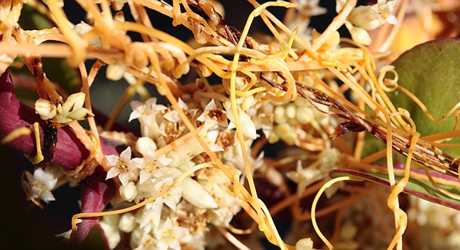
Stringy witch’s hair will kill its host plant.
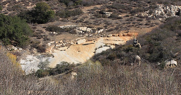
Granite erosion
The hike along Sloan Canyon is on a portion of the California Riding and Hiking Trail that offers views of Loveland Reservoir and surrounding mountains before descending into a rich riparian area along the Sweetwater River. The hike begins in an unshaded chaparral area with exposed large granitic slabs that gradually transforms into a shaded, riparian woodland at the canyon bottom. One can experience the difference that water can make for the surrounding habitat on this hike. The canyon’s sensitive habitat supports several rare or endangered plants and animals. It also has great views and provides a deep peacefulness that is a welcome change from the hustle of the city. The canyon itself was named for Hampton Sloane, a rancher who lived in the Dehesa area in the 1890s. Through time, the “e” was dropped from the name.
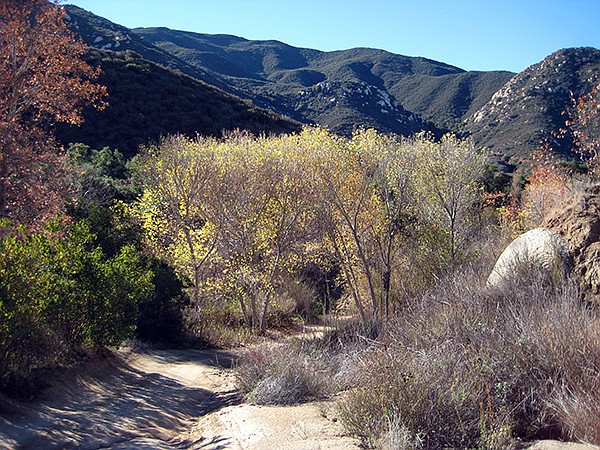
Riparian area, Sloan Canyon
Start out with sturdy shoes, as the trail is steep and eroded in places once passing the houses on the way south for a distance of about a quarter of a mile, then follow the sign to the California Riding and Hiking Trail on the left. Before descending into Sloan Canyon, take a moment to view Sycuan Peak directly to the south with Lyons and Lawson peaks slightly southeast and a bit higher in elevation. Lyons Peak forest-fire lookout towers changed from looking like a telephone booth, then a square structure perched on a tall vertical rock, and now a 41-foot tower that is not currently in use. At just under 1.35 miles, the trail continues down into the canyon, passing a few scattered houses to the west.
On the hillsides you can see fine examples of exfoliated granite slabs. Exfoliation is the process in which rocks weather by peeling off in sheets rather than eroding grain by grain; it can happen in thin layers on individual boulders or it can take place in thick slabs as it does here in Sloan Canyon, as evidenced by the large, smooth granite pieces poking through the chaparral.
Along the way, keep your eyes out for flowers blooming among the laurel sumac, ceanothus, and chamise that line the road, which may include lilies and dodder. Dodder, or witch’s hair, is easy to recognize -— look for orangey-yellow spaghetti-like strands that twine around a host plant. Dodder is a parasitic plant that contains no chlorophyll and absorbs food and water from its host plant through haustoria, root-like organs that penetrate the cells of the host plant and may eventually kill it. The flowers are tiny and yellow-white bell-like lobbed clusters that are easily overlooked when they appear. Also look for small animals, such as the western fence lizard and birds that may be in the area, including the endangered least Bell’s vireo.
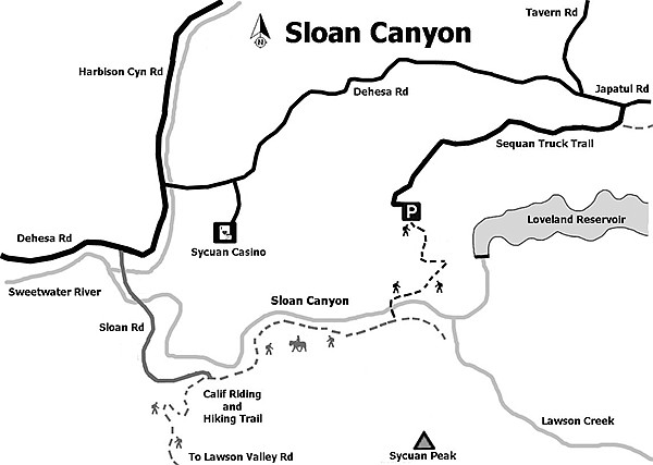
Map of Sloan Canyon
As you descend farther into the canyon, note that the vegetation changes from chaparral to riparian woodland. Riparian means relating to wetlands adjacent to rivers and/or streams. Descending, you will find the Sweetwater River that runs through the bottom of the canyon. The chaparral gives way to sycamore, oak, cottonwoods, and willow trees as you approach an old bridge crossing the river. Even in drought conditions when the river might be dry, the riparian growth will be healthy as it taps into underground sources of water. The trees still provide a nice shaded spot to rest and eat lunch or a snack before heading back up the hill to your vehicle.
The trip can be extended by continuing a ways up toward Dehesa Road before returning to your vehicle.
Distance from downtown San Diego: 35 miles. Allow 45 minutes driving time (Alpine). From I-8, exit south onto Tavern Rd. for 2.8 miles then continue east onto Japatul Rd/Japatul Lane for 0.3 mile past Dehesa Rd. Turn right (south) onto Sequan Truck Trail for 3 miles. The pavement ends after 2.8 miles with the last 0.2 mile dirt to a sharp turn to the right (south) where there is a turnout in the northeast corner used for parking.
Hiking length: 4 miles out-and-back. Allow up to 3 hours.
Difficulty: Moderately strenuous with an elevation gain/loss of up to 1000 feet. The best time to hike is November through May. Shade found only in the riparian woodland areas. No facilities or water. This is a multi-use trail where bicyclists yield to hikers who both yield to equestrians. Dogs allowed.
Here's something you might be interested in.
Experience dramatic transition in Sloan Canyon
No city hustle here
Experience dramatic transition in Sloan Canyon
No city hustle here
Stringy witch’s hair will kill its host plant.
Granite erosion
The hike along Sloan Canyon is on a portion of the California Riding and Hiking Trail that offers views of Loveland Reservoir and surrounding mountains before descending into a rich riparian area along the Sweetwater River. The hike begins in an unshaded chaparral area with exposed large granitic slabs that gradually transforms into a shaded, riparian woodland at the canyon bottom. One can experience the difference that water can make for the surrounding habitat on this hike. The canyon’s sensitive habitat supports several rare or endangered plants and animals. It also has great views and provides a deep peacefulness that is a welcome change from the hustle of the city. The canyon itself was named for Hampton Sloane, a rancher who lived in the Dehesa area in the 1890s. Through time, the “e” was dropped from the name.
Riparian area, Sloan Canyon
Start out with sturdy shoes, as the trail is steep and eroded in places once passing the houses on the way south for a distance of about a quarter of a mile, then follow the sign to the California Riding and Hiking Trail on the left. Before descending into Sloan Canyon, take a moment to view Sycuan Peak directly to the south with Lyons and Lawson peaks slightly southeast and a bit higher in elevation. Lyons Peak forest-fire lookout towers changed from looking like a telephone booth, then a square structure perched on a tall vertical rock, and now a 41-foot tower that is not currently in use. At just under 1.35 miles, the trail continues down into the canyon, passing a few scattered houses to the west.
On the hillsides you can see fine examples of exfoliated granite slabs. Exfoliation is the process in which rocks weather by peeling off in sheets rather than eroding grain by grain; it can happen in thin layers on individual boulders or it can take place in thick slabs as it does here in Sloan Canyon, as evidenced by the large, smooth granite pieces poking through the chaparral.
Along the way, keep your eyes out for flowers blooming among the laurel sumac, ceanothus, and chamise that line the road, which may include lilies and dodder. Dodder, or witch’s hair, is easy to recognize -— look for orangey-yellow spaghetti-like strands that twine around a host plant. Dodder is a parasitic plant that contains no chlorophyll and absorbs food and water from its host plant through haustoria, root-like organs that penetrate the cells of the host plant and may eventually kill it. The flowers are tiny and yellow-white bell-like lobbed clusters that are easily overlooked when they appear. Also look for small animals, such as the western fence lizard and birds that may be in the area, including the endangered least Bell’s vireo.
Map of Sloan Canyon
As you descend farther into the canyon, note that the vegetation changes from chaparral to riparian woodland. Riparian means relating to wetlands adjacent to rivers and/or streams. Descending, you will find the Sweetwater River that runs through the bottom of the canyon. The chaparral gives way to sycamore, oak, cottonwoods, and willow trees as you approach an old bridge crossing the river. Even in drought conditions when the river might be dry, the riparian growth will be healthy as it taps into underground sources of water. The trees still provide a nice shaded spot to rest and eat lunch or a snack before heading back up the hill to your vehicle.
The trip can be extended by continuing a ways up toward Dehesa Road before returning to your vehicle.
Distance from downtown San Diego: 35 miles. Allow 45 minutes driving time (Alpine). From I-8, exit south onto Tavern Rd. for 2.8 miles then continue east onto Japatul Rd/Japatul Lane for 0.3 mile past Dehesa Rd. Turn right (south) onto Sequan Truck Trail for 3 miles. The pavement ends after 2.8 miles with the last 0.2 mile dirt to a sharp turn to the right (south) where there is a turnout in the northeast corner used for parking.
Hiking length: 4 miles out-and-back. Allow up to 3 hours.
Difficulty: Moderately strenuous with an elevation gain/loss of up to 1000 feet. The best time to hike is November through May. Shade found only in the riparian woodland areas. No facilities or water. This is a multi-use trail where bicyclists yield to hikers who both yield to equestrians. Dogs allowed.