Here's something you might be interested in.
Ask a Hipster — Advice you didn't know you needed
Big Screen — Movie commentary
Blurt — Music's inside track
Booze News — San Diego spirits
Classical Music — Immortal beauty
Classifieds — Free and easy
Cover Stories — Front-page features
Drinks All Around — Bartenders' drink recipes
Excerpts — Literary and spiritual excerpts
Feast! — Food & drink reviews
Feature Stories — Local news & stories
Fishing Report — What’s getting hooked from ship and shore
From the Archives — Spotlight on the past
Golden Dreams — Talk of the town
The Gonzo Report — Making the musical scene, or at least reporting from it
Letters — Our inbox
Movies@Home — Local movie buffs share favorites
Movie Reviews — Our critics' picks and pans
Musician Interviews — Up close with local artists
Neighborhood News from Stringers — Hyperlocal news
News Ticker — News & politics
Obermeyer — San Diego politics illustrated
Outdoors — Weekly changes in flora and fauna
Overheard in San Diego — Eavesdropping illustrated
Poetry — The old and the new
Reader Travel — Travel section built by travelers
Reading — The hunt for intellectuals
Roam-O-Rama — SoCal's best hiking/biking trails
San Diego Beer — Inside San Diego suds
SD on the QT — Almost factual news
Sheep and Goats — Places of worship
Special Issues — The best of
Street Style — San Diego streets have style
Surf Diego — Real stories from those braving the waves
Theater — On stage in San Diego this week
Tin Fork — Silver spoon alternative
Under the Radar — Matt Potter's undercover work
Unforgettable — Long-ago San Diego
Unreal Estate — San Diego's priciest pads
Your Week — Daily event picks
Baja zen: Guadalupe Canyon's oasis
Hidden palm oasis and hot-springs camping 4 hours southeast.
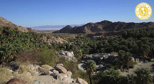
Morning over the Guadalupe Canyon oasis.
It's midafternoon, and the hot sun beats down on a remote desert road laying before me. I'm deep in the Mexican desert, thinking of shinrin-yoku. Shinrin-yoku is the Japanese practice of "forest bathing" to enhance health and wellbeing.
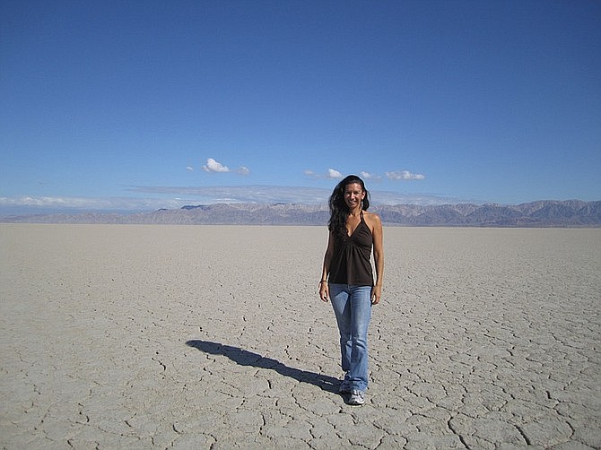
The author on Baja Norte's dry Laguna Salada.
Here in Baja California, I'm practicing a similar form that's a bit hotter.
Desert therapy.
¡Vamos!
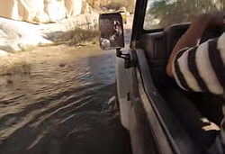
This weekend I'm going camping in Guadalupe Hot Springs, a oasis in the middle of the northern Mexican desert. Most campsites have their own private hot tub that's fed by geothermal spring water between 85-110 degrees and untreated. But in order to get there, I recommend having an all-wheel drive vehicle (or 4X4), since the last leg of the trip is on a rugged dirt road.
In less than two hours the car was packed with the basic necessities; tent, cooler, stove, towel, and most importantly, 10 gallons of water. My plan was to drive during the day in order to arrive in Guadalupe Hot Springs before sunset.
The concrete jungle slowly fades away as I head east out of San Diego, venturing through the towns of Jamul and Dulzura. Finally, I spot Mexico in the horizon. I cross the border in Tecate, stopping for tacos and supplies. Then, heading east on the Federal Highway 2, I pass through La Rumorosa, descending down into what seems like another world. This is the last leg of the trip and my favorite part. The view is striking. I turn off the highway and drive on to the Laguna Salada, a vast dry lake bed some 10 meters below sea level.
Video:
Guadalupe Canyon (& more Baja)
Three and a half hours later, I arrive at my destination, El Canyon de Guadalupe.
My designated campsite is called La Zorra ("The Fox") and features a tub that has a beautiful view of the valley, shaded by fan palms. There's a picnic table and a tiny little sink. The next two days I hike, visit waterfalls, see ancient petroglyphs, learn about the native tribes that used to inhabit the area, and finish the day by soaking in my own private hot tub.
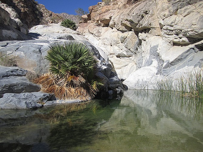
A short hike from the campsite area leads you to this cool spring.
Guadalupe Hot Springs is one of Baja California's gems. Looking up at a star-filled sky, I wonder if we will ever pump millions of dollars into researching the effects of nature on the immune system like the Japanese have. Can heading out into nature really cure our ailments?
Yes, I conclude. Desert therapy, like shinrin-yoku, is beneficial to the body, mind and spirit. I see a falling star and close my eyes.
Getting there: half the fun
If you are coming from the San Diego area, here's the fastest route to arrive at Guadalupe Canyon Oasis. The Tecate border crossing is quiet, and open from 5 A.M. to 11 P.M. (This route includes a toll road.)
- From I-5 southbound, take exit 15B onto I-94 East/ MLK Jr. Freeway.
- After 13 miles on I-94 East, turn right to stay on 94 East/Campo Road. Continue on 94 East to Highway 188.
- Turn right on 188/Tecate Road. This should take you right to the border crossing.
- You'll emerge from the border crossing onto Calle Presidente Lazaro Cardenas, heading south. Two blocks south of the border, turn left onto Calle Benito Juarez past Tecate's charming main plaza.
- Make an immediate right onto Calle Presidente Pascal Ortiz Rubio, and continue south.
- After about 1.5 miles and at the top of the hill, you'll hit the "cuota" or toll road, Highway 2, which runs east (Mexicali)/west (Tijuana). Head east towards Mexicali.
- After approximately 30 miles, you'll pass through a small town called La Rumorosa (last chance for supplies) and begin to descend through a scenic rocky area for several miles. The road is steep and views are beautiful.
- From here you'll emerge onto a very large flat expanse, the beginning of the Laguna Salda. After about six miles you will come to a safety checkpoint; in most instances you'll just be waved on. After about four miles, keep an eye out for the turn-off sign: "CAÑÓN DE GUADALUPE." This is the graded dirt route to the oasis.
Note: the graded dirt route – the more "official" road to Guadalupe Canyon Oasis – is recommended for first-time visitors . It's a little slower than the dry lake route (2.7 miles further), but generally the safer way to go if the eastern route is likely to be muddy. For more info, visit the Guadalupe Canyon Oasis site.
About the author
A producer and aspiring writer, Lorena Santana has spent the last three years working on her documentary and travel show (and labor of love), Barefoot in Baja.
Website: barefootinbaja.com
Facebook: facebook.com/BarefootInBaja
Map
Guadalupe Canyon Hot Springs
Guadalupe Canyon Hot Springs
Here's something you might be interested in.
Baja zen: Guadalupe Canyon's oasis
Hidden palm oasis and hot-springs camping 4 hours southeast.
Baja zen: Guadalupe Canyon's oasis
Hidden palm oasis and hot-springs camping 4 hours southeast.
Morning over the Guadalupe Canyon oasis.
It's midafternoon, and the hot sun beats down on a remote desert road laying before me. I'm deep in the Mexican desert, thinking of shinrin-yoku. Shinrin-yoku is the Japanese practice of "forest bathing" to enhance health and wellbeing.
The author on Baja Norte's dry Laguna Salada.
Here in Baja California, I'm practicing a similar form that's a bit hotter.
Desert therapy.
¡Vamos!
This weekend I'm going camping in Guadalupe Hot Springs, a oasis in the middle of the northern Mexican desert. Most campsites have their own private hot tub that's fed by geothermal spring water between 85-110 degrees and untreated. But in order to get there, I recommend having an all-wheel drive vehicle (or 4X4), since the last leg of the trip is on a rugged dirt road.
In less than two hours the car was packed with the basic necessities; tent, cooler, stove, towel, and most importantly, 10 gallons of water. My plan was to drive during the day in order to arrive in Guadalupe Hot Springs before sunset.
The concrete jungle slowly fades away as I head east out of San Diego, venturing through the towns of Jamul and Dulzura. Finally, I spot Mexico in the horizon. I cross the border in Tecate, stopping for tacos and supplies. Then, heading east on the Federal Highway 2, I pass through La Rumorosa, descending down into what seems like another world. This is the last leg of the trip and my favorite part. The view is striking. I turn off the highway and drive on to the Laguna Salada, a vast dry lake bed some 10 meters below sea level.
Video:
Guadalupe Canyon (& more Baja)
Three and a half hours later, I arrive at my destination, El Canyon de Guadalupe.
My designated campsite is called La Zorra ("The Fox") and features a tub that has a beautiful view of the valley, shaded by fan palms. There's a picnic table and a tiny little sink. The next two days I hike, visit waterfalls, see ancient petroglyphs, learn about the native tribes that used to inhabit the area, and finish the day by soaking in my own private hot tub.
A short hike from the campsite area leads you to this cool spring.
Guadalupe Hot Springs is one of Baja California's gems. Looking up at a star-filled sky, I wonder if we will ever pump millions of dollars into researching the effects of nature on the immune system like the Japanese have. Can heading out into nature really cure our ailments?
Yes, I conclude. Desert therapy, like shinrin-yoku, is beneficial to the body, mind and spirit. I see a falling star and close my eyes.
Getting there: half the fun
If you are coming from the San Diego area, here's the fastest route to arrive at Guadalupe Canyon Oasis. The Tecate border crossing is quiet, and open from 5 A.M. to 11 P.M. (This route includes a toll road.)
- From I-5 southbound, take exit 15B onto I-94 East/ MLK Jr. Freeway.
- After 13 miles on I-94 East, turn right to stay on 94 East/Campo Road. Continue on 94 East to Highway 188.
- Turn right on 188/Tecate Road. This should take you right to the border crossing.
- You'll emerge from the border crossing onto Calle Presidente Lazaro Cardenas, heading south. Two blocks south of the border, turn left onto Calle Benito Juarez past Tecate's charming main plaza.
- Make an immediate right onto Calle Presidente Pascal Ortiz Rubio, and continue south.
- After about 1.5 miles and at the top of the hill, you'll hit the "cuota" or toll road, Highway 2, which runs east (Mexicali)/west (Tijuana). Head east towards Mexicali.
- After approximately 30 miles, you'll pass through a small town called La Rumorosa (last chance for supplies) and begin to descend through a scenic rocky area for several miles. The road is steep and views are beautiful.
- From here you'll emerge onto a very large flat expanse, the beginning of the Laguna Salda. After about six miles you will come to a safety checkpoint; in most instances you'll just be waved on. After about four miles, keep an eye out for the turn-off sign: "CAÑÓN DE GUADALUPE." This is the graded dirt route to the oasis.
Note: the graded dirt route – the more "official" road to Guadalupe Canyon Oasis – is recommended for first-time visitors . It's a little slower than the dry lake route (2.7 miles further), but generally the safer way to go if the eastern route is likely to be muddy. For more info, visit the Guadalupe Canyon Oasis site.
About the author
A producer and aspiring writer, Lorena Santana has spent the last three years working on her documentary and travel show (and labor of love), Barefoot in Baja.
Website: barefootinbaja.com
Facebook: facebook.com/BarefootInBaja
Map
Guadalupe Canyon Hot Springs
Guadalupe Canyon Hot Springs