Here's something you might be interested in.
Ask a Hipster — Advice you didn't know you needed
Big Screen — Movie commentary
Blurt — Music's inside track
Booze News — San Diego spirits
Classical Music — Immortal beauty
Classifieds — Free and easy
Cover Stories — Front-page features
Drinks All Around — Bartenders' drink recipes
Excerpts — Literary and spiritual excerpts
Feast! — Food & drink reviews
Feature Stories — Local news & stories
Fishing Report — What’s getting hooked from ship and shore
From the Archives — Spotlight on the past
Golden Dreams — Talk of the town
The Gonzo Report — Making the musical scene, or at least reporting from it
Letters — Our inbox
Movies@Home — Local movie buffs share favorites
Movie Reviews — Our critics' picks and pans
Musician Interviews — Up close with local artists
Neighborhood News from Stringers — Hyperlocal news
News Ticker — News & politics
Obermeyer — San Diego politics illustrated
Outdoors — Weekly changes in flora and fauna
Overheard in San Diego — Eavesdropping illustrated
Poetry — The old and the new
Reader Travel — Travel section built by travelers
Reading — The hunt for intellectuals
Roam-O-Rama — SoCal's best hiking/biking trails
San Diego Beer — Inside San Diego suds
SD on the QT — Almost factual news
Sheep and Goats — Places of worship
Special Issues — The best of
Street Style — San Diego streets have style
Surf Diego — Real stories from those braving the waves
Theater — On stage in San Diego this week
Tin Fork — Silver spoon alternative
Under the Radar — Matt Potter's undercover work
Unforgettable — Long-ago San Diego
Unreal Estate — San Diego's priciest pads
Your Week — Daily event picks
Del Dios Gorge Trail, a small piece of the Coast to Crest Trail
Hike to the “Rattlesnake” Viewing Platform to view Lake Hodges Dam
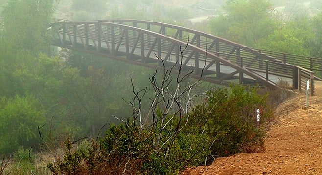
An iron bridge spans Del Dios Gorge.
Del Dios Gorge overlook to Lake Hodges Dam
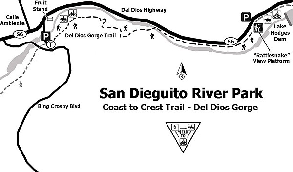
This trail is part of the Coast to Crest Trail of the San Dieguito River Park. The 70-mile planned Coast to Crest Trail will extend one day from Volcan Mountain near Julian to the shore at Del Mar. Del Dios Gorge is within this planned area, but only part of it is accessible. Del Dios Gorge is partly inundated by the Lake Hodges Reservoir created in 1918 on completion of the Lake Hodges Dam.
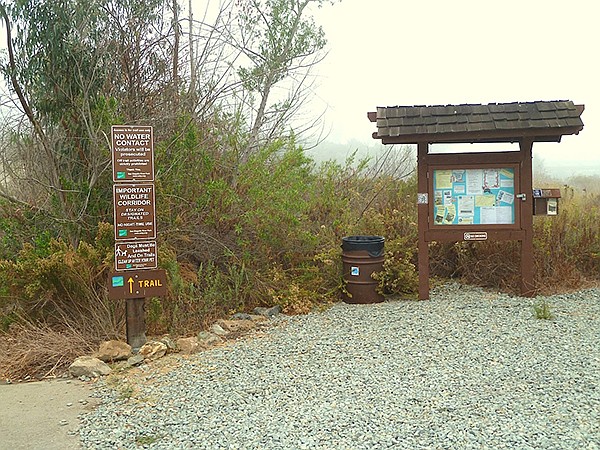
Start of the Del Dios trail
Different plant communities are found along the Del Dios trail. From the parking area, head east toward the dam. The plants found on the early part of the trail are common to the coastal chaparral habitat, including sagebrush, white sage, and some large coast prickly pear cactus. Several interpretive panels along the route describe the history and fauna of the area, including bats. At about the 1.5-mile mark, the trail descends to a steel-railed bridge that crosses the San Dieguito River and enters a riparian area paralleling the riverbed. Although it is a riverbed, you will probably see no more than a couple of stagnant pools among the many large granitic boulders. There is enough water, however, to support groupings of coast live oaks and various species of willow.
One of the historic highlights of the trail is the Hodges Flume along the north side of the gorge (to the left as you proceed to the dam). It is not used today but was once a gravity water transporter to the San Dieguito Reservoir, four miles to the west.
The trail is undoubtedly at its best after some rain, which should provide some water flow in the river and awaken the coast chaparral and riparian plants that might come into flower. The only drawback of this hike is the background vehicle noise from the Del Dios Highway.
Del Dios Gorge
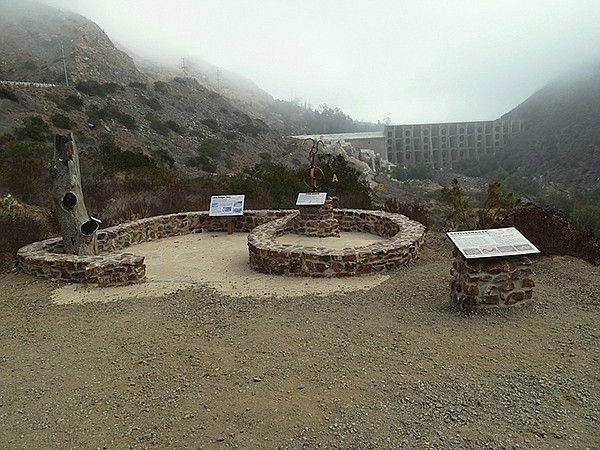
The Rattlesnake Viewing Platform is the turnaround point and a good spot for lunch or a snack. The platform was named not for any rattlesnakes in the area but rather for the native rock that was shaped into the form of a rattlesnake. Here there is an interpretive panel that explains the place of rattlesnakes in the ecosystem, a burned “dead” black oak tree on the platform that addresses the impacts of wildfires, and a sculpture with a pipe ring scope that lines up features at the dam, including the spillway, the bulwarks, and the river below. The view from this point is the concrete-arch Lake Hodges Dam (see 2/14/13 “Roam-O-Rama”), which impounds the San Dieguito River. After taking in the views and resting, return to the parking lot along the same route.
There is also parking along Del Dios Highway just above the dam viewing area. Parking there is limited and entry there would access the trail from this point.
Distance from downtown San Diego: 30 miles. Allow 50 minutes driving time. From CA-163N, take I-805N to I-5N and exit east on Via de la Valle after 20.5 miles. Drive east on Via de la Valle, which is SR-6. SR-6 has several name changes heading east, beginning with Via de la Valle, then Paseo Delicias and finally Del Dios Hwy. It is 13 miles from I-5 on SR-6 to Calle Ambiente. After passing Calle Ambiente, turn in at the “Lemon Twist” fruit stand on the right. There is a road marked with an “SDRP” (San Diego River Park) sign that leads to the parking area.
Hiking length: 4.5 miles out and back.
Difficulty: Easy. Elevation gain/loss 200 feet. The trail runs parallel to Del Dios Highway. The gravel parking lot at the start of the trail provides parking for about a dozen vehicles. Be prepared to share the trail with runners, dogs, mountain bikers, and maybe equestrians. No facilities or water.
Here's something you might be interested in.
Del Dios Gorge Trail, a small piece of the Coast to Crest Trail
Hike to the “Rattlesnake” Viewing Platform to view Lake Hodges Dam
Del Dios Gorge Trail, a small piece of the Coast to Crest Trail
Hike to the “Rattlesnake” Viewing Platform to view Lake Hodges Dam
An iron bridge spans Del Dios Gorge.
Del Dios Gorge overlook to Lake Hodges Dam
This trail is part of the Coast to Crest Trail of the San Dieguito River Park. The 70-mile planned Coast to Crest Trail will extend one day from Volcan Mountain near Julian to the shore at Del Mar. Del Dios Gorge is within this planned area, but only part of it is accessible. Del Dios Gorge is partly inundated by the Lake Hodges Reservoir created in 1918 on completion of the Lake Hodges Dam.
Start of the Del Dios trail
Different plant communities are found along the Del Dios trail. From the parking area, head east toward the dam. The plants found on the early part of the trail are common to the coastal chaparral habitat, including sagebrush, white sage, and some large coast prickly pear cactus. Several interpretive panels along the route describe the history and fauna of the area, including bats. At about the 1.5-mile mark, the trail descends to a steel-railed bridge that crosses the San Dieguito River and enters a riparian area paralleling the riverbed. Although it is a riverbed, you will probably see no more than a couple of stagnant pools among the many large granitic boulders. There is enough water, however, to support groupings of coast live oaks and various species of willow.
One of the historic highlights of the trail is the Hodges Flume along the north side of the gorge (to the left as you proceed to the dam). It is not used today but was once a gravity water transporter to the San Dieguito Reservoir, four miles to the west.
The trail is undoubtedly at its best after some rain, which should provide some water flow in the river and awaken the coast chaparral and riparian plants that might come into flower. The only drawback of this hike is the background vehicle noise from the Del Dios Highway.
Del Dios Gorge
The Rattlesnake Viewing Platform is the turnaround point and a good spot for lunch or a snack. The platform was named not for any rattlesnakes in the area but rather for the native rock that was shaped into the form of a rattlesnake. Here there is an interpretive panel that explains the place of rattlesnakes in the ecosystem, a burned “dead” black oak tree on the platform that addresses the impacts of wildfires, and a sculpture with a pipe ring scope that lines up features at the dam, including the spillway, the bulwarks, and the river below. The view from this point is the concrete-arch Lake Hodges Dam (see 2/14/13 “Roam-O-Rama”), which impounds the San Dieguito River. After taking in the views and resting, return to the parking lot along the same route.
There is also parking along Del Dios Highway just above the dam viewing area. Parking there is limited and entry there would access the trail from this point.
Distance from downtown San Diego: 30 miles. Allow 50 minutes driving time. From CA-163N, take I-805N to I-5N and exit east on Via de la Valle after 20.5 miles. Drive east on Via de la Valle, which is SR-6. SR-6 has several name changes heading east, beginning with Via de la Valle, then Paseo Delicias and finally Del Dios Hwy. It is 13 miles from I-5 on SR-6 to Calle Ambiente. After passing Calle Ambiente, turn in at the “Lemon Twist” fruit stand on the right. There is a road marked with an “SDRP” (San Diego River Park) sign that leads to the parking area.
Hiking length: 4.5 miles out and back.
Difficulty: Easy. Elevation gain/loss 200 feet. The trail runs parallel to Del Dios Highway. The gravel parking lot at the start of the trail provides parking for about a dozen vehicles. Be prepared to share the trail with runners, dogs, mountain bikers, and maybe equestrians. No facilities or water.