Here's something you might be interested in.
Ask a Hipster — Advice you didn't know you needed
Big Screen — Movie commentary
Blurt — Music's inside track
Booze News — San Diego spirits
Classical Music — Immortal beauty
Classifieds — Free and easy
Cover Stories — Front-page features
Drinks All Around — Bartenders' drink recipes
Excerpts — Literary and spiritual excerpts
Feast! — Food & drink reviews
Feature Stories — Local news & stories
Fishing Report — What’s getting hooked from ship and shore
From the Archives — Spotlight on the past
Golden Dreams — Talk of the town
The Gonzo Report — Making the musical scene, or at least reporting from it
Letters — Our inbox
Movies@Home — Local movie buffs share favorites
Movie Reviews — Our critics' picks and pans
Musician Interviews — Up close with local artists
Neighborhood News from Stringers — Hyperlocal news
News Ticker — News & politics
Obermeyer — San Diego politics illustrated
Outdoors — Weekly changes in flora and fauna
Overheard in San Diego — Eavesdropping illustrated
Poetry — The old and the new
Reader Travel — Travel section built by travelers
Reading — The hunt for intellectuals
Roam-O-Rama — SoCal's best hiking/biking trails
San Diego Beer — Inside San Diego suds
SD on the QT — Almost factual news
Sheep and Goats — Places of worship
Special Issues — The best of
Street Style — San Diego streets have style
Surf Diego — Real stories from those braving the waves
Theater — On stage in San Diego this week
Tin Fork — Silver spoon alternative
Under the Radar — Matt Potter's undercover work
Unforgettable — Long-ago San Diego
Unreal Estate — San Diego's priciest pads
Your Week — Daily event picks
How to get into U.S. via the Arroyo Alamar
The curious walking reeds of the Tijuana River
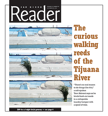
“There’s no real reason to do things like this,” a soft-spoken Yoav Admoni says as he binds fresh-cut reeds to a collapsible laundry hamper with a spool of wire.
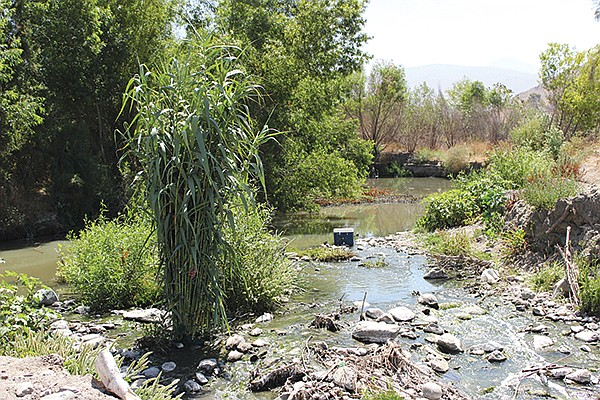
It’s a beautiful day in the riparian woods of Arroyo Alamar. Birds chirp their melodies. Squirrels sneak curious glimpses from willow trees. Sunflowers bow to a mild summer breeze. Surrounded by orange smatterings of nasturtium, castor brush, and cachanillas, it’s easy to forget that we are just a stone’s throw away from one of the sketchiest neighborhoods in Tijuana.
Just 40 years ago, Colonia Granja Familiares was an East TJ bastion of ranchos and farmland. Today, thanks to rapid and poorly regulated urbanization, the place is a patchwork of industrial blocks and makeshift shanties surrounding the few remaining miles of Arroyo Alamar, which serves as a dumping ground for the adjacent impoverished communities.
“All I’m trying to do is investigate how green spaces reflect political conflict,” the Israeli performance artist says, “so I focused on the Tijuana River as a mirror of the political conflict in Tijuana and also between Mexico and the U.S.”
Admoni’s goal? To wade west 13 or so miles from the Arroyo Alamar, into the northwest flowing Tijuana River canal, through the deportee purgatory of El Bordo, and clear across the border to the U.S.
Yoav Admoni begins the walk (that’s him in the plant suit, left).
Making modifications
Oh, and he’ll be dressed like a plant.
“I’m always waiting for people to think that I’m being totally irrational, but people always respond very positively and in some bizarre way understand the logic of doing the thing,” Admoni told me a few nights prior at a bar in Centro. “Or at least they pretend to.”
And while the idea of a foreigner just waltzing into America wearing a cloak of regional flora may sound audacious, Admoni notes: “For me the most interesting part is the meeting of this image with other plants in the river. It’s not about crossing the border. It’s about describing the movement of the water and asking, ‘What is a river in this context?’”
As the third installment in his Threesome with Nature thesis project for the Bauhaus University in Weimar, Germany, “Plant Migration” was initially set to start at the base of the Abelardo L. Rodríguez Dam about 6.5 miles southwest. The reservoir feeds a tributary that merges with Arroyo Alamar to become the Tijuana River canal about 4 miles west of where we stand. But, while the Arroyo las Palmas waterway from the dam is completely canalized, Arroyo Alamar still has about two miles of its natural ecology intact before becoming the Tecate River upstream to the east, which crosses south from Barrett Lake, Lake Morena, and the headwaters of Cottonwood Creek in the Laguna Mountains. The contrast of countryside and concrete drew Admoni to Arroyo Alamar.
But even this rare green space (Tijuana has 0.28 square meter per person; San Diegans boast about 40) is doomed to be reduced to a concrete ditch. On a February 13 Milenio Radio broadcast, Eduardo Ledesma Romo, the regional delegate of Conagua (the national water commission), stated that the canalization of Arroyo Alamar was 75 percent complete and that the final three kilometers would be developed as planned following a contract bid. As reported by the Reader’s Dave Good (“Showdown on the Rio Alamar,” September 5, 2012), the remaining floodplain will then be filled and graded to make way for a new vehicle thoroughfare.
When the $47-million Alamar lining project was launched in May 2011, Conagua said the project would not only bolster the economy by promoting development and increasing property values, but it would also save lives. José Luis Luege, Conagua’s director at the time, claimed that canalizing the Alamar would protect 40,000 residents and prevent squatters from constructing shacks in the floodplain. The Alamar, like all waterways in Mexico, is under federal jurisdiction. As such, a Conagua document states that the region “has historically been one of the areas of the city most susceptible to unregulated settlements, due to the absence of control and supervision inside a federal zone within a municipality.”
In fact, squatters have lived along the river since the 1940s. Until the 1970s, the settlement of up to 25,000 residents was known as Cartolandia, named after the scavenged cardboard cartons used to construct the shanties.
Professor Jorge Mancilla, a graduate of Neurobiology at UCSD and England’s University of Cambridge, reported his first-hand account of the removal of Cartolandia to the Reader in 2002 (“This Isn’t the Same Country, This Isn’t the Same Town,” October 10, 2002).
“For decades there had been this squatters’ neighborhood in the Tijuana riverbed right up near the border,” Mancilla said. “Hundreds, maybe thousands, of shacks of the poorest migrants…. Well, for a ‘new Tijuana,’ [part of a plan drafted in Mexico City in order to ‘Mexicanize’ Tijuana] this was intolerable. The land was very valuable. It was flat and there was little flat land in Tijuana to build on. There was this plan to cement in the riverbed and put in flood control. So, in November 1973, the government went in with bulldozers and soldiers and wiped out Cartolandia. Leveled it to the ground. The refugees from Cartolandia went a little east and took the land that became Tierra y Libertad. That’s the story. Part of what was Cartolandia is where the Tijuana Cultural Center now stands.”
Regardless, an April, 2012 dispatch from El Sol de Tijuana asserted that Cartolandia still existed in Arroyo Alamar, where hundreds of shanties were slapped together with whatever material was available. These settlements have since been eradicated by the eastward canalization of the Alamar, with an estimated 5000 residents displaced in the process.
These memories still fresh in their minds, over 300 demonstrators — local families toting banners and strumming Son Jarocho folk tunes — marched along Arroyo Alamar a few days after Conagua’s radio broadcast in a gesture of solidarity that follows a three-year dialogue with state and federal authorities to stop the canalization of the creek. But it’s not just a handful of concerned citizens who have taken an interest in the area. At least 14 nonprofit organizations have also dedicated themselves to defending the area. One of them is Yo Soy el Alamar.
Project coordinator Jorge Calderón points out the pathways that he and his team sculpted throughout the woods while Admoni harvests more reeds and silently weaves them onto his basket.
“We are using what is here — tires, rocks, garbage — to make the land more beautiful,” Calderón says. “It’s for everybody: the rich, the poor, the homeless, and people with homes. We have only three kilometers of Alamar left, so we want to preserve it for people to take walks, have a carne asada, or dance, if they would like to.”
In addition to an abundance of plant life, Arroyo Alamar is home to several species of wildlife, some of which are classified as threatened or protected. Regardless, the creek and its surrounding ecology are slated to be sold to the highest-bidding contractor as soon as possible.
“Concrete is death,” Calderón says, “and you can see it in the change from nature to a channel to a water-treatment plant to an estuary once the river crosses the border.”
In fact, as Dr. Ian Malcolm once famously stated, “Life, uh… finds a way.” A quick search on Google Earth reveals a canal full of flora, albeit to a much lesser degree than what one finds in Alamar forest. The images, probably taken around 2012, show just how far canalization has come (for reference, the canal now begins about 800 meters west of the words “Zona Ecológica Alamar”) and how much riparian ecology was destroyed in the process. Furthermore, Conagua performs regular sweeps of the canal, removing all plants and garbage with bulldozers.
César García Valderrama, program director at Nativ@s de las Californias (a nonprofit focused on the conservation of natural habitats in Baja), stresses the gravity of the conflict.
“The forest is a truly important place regionally, as there are no riparian corridors left in urban Tijuana. The channelization of the Tijuana River destroyed one of the most important riparian flyways in Pacific North America. It was a true bio-diverse haven.”
Ana Elena Espinoza López , director general of CEUSS (Baja California’s center for sustainability, environment, and development), says the surrounding ecosystem and farmland will be squelched out of existence within five years if the remainder of Arroyo Alamar is canalized.
Rene Peralta, director of Woodbury University Graduate School of Architecture, Landscape + Urbanism, and his class offered an alternative that would preserve and even increase green spaces in Tijuana.
“During our research on the restoration of urban rivers, we visited Los Angeles and met with colleagues and the organizations involved in the efforts to bring back the L.A. River as a community amenity,” Peralta says. “We learned about the different ways to control flooding and still have an open and natural river that can serve as public space. After our visit, we continued to look at other cities in Spain, Korea, and the U.S. and began a six-week design studio with students from Washington University in St. Louis.”
As a result, Peralta and his students developed a two-part proposal for the reinvention of Arroyo Alamar.
“One was to actually propose a new way of channelizing the river through a more natural and expanded cross section (using less concrete, more stepped paths, and leaving as much of the local flora as possible). Since the Alamar is a seasonal river, the design also included, where possible, the designation of areas for recreation and leisure in order to create public spaces for the adjacent communities, as the Alamar River flows through where nearly half of the population of the city resides. The other approach was not as ideal but looked at the canyons that feed into the Alamar and transforming them into clean, linear parks that people use to move up and down the Tijuana topography while at the same time helping to reduce wastewater and trash deposits into the Alamar, which then connects to the Tijuana River and ends up in the Pacific Ocean.”
In a recent interview with Milenio, Peralta acknowledged that work would be necessary but called it “a pity that they are considering the project as if we were doing it 30 or 40 years ago, only thinking the singular logic of putting concrete on the problem and that’s it, like sweeping garbage under the rug.”
A proposal similar to Peralta’s, developed by San Diego State University civil engineering professor Dr. Victor Miguel Ponce and his team, has already been approved by Mexican academia and officials, García of Nativ@s de las Californias notes. The proposal re-envisions the canal as a public space divided into nature parks, recreation areas, green houses, and equestrian zones.
“The project that should have been developed was the ecological project designed by SDSU,” García says. “Yet, for reasons that have never been clear, Mexican authorities decided to cancel that project and implement an archaic and unsustainable method.”
Paul Ganster, director of the Institute for Regional Studies of the Californias at San Diego State University, noted in a 2012 U-T San Diego report that, “Development pressure and the desire for immediate profit is so strong in an urbanized place like Tijuana that it’s quite difficult to resist those forces.”
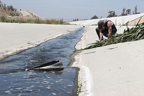
Admoni’s plant suit is finished now. It’s about eight feet tall, weighs maybe 60 pounds, and is so dense you would never guess it hides a stoic young man from Tel-Aviv strapping the thing to his shoulders with improvised suspenders. The comical ensemble is made out of so-called giant reeds, or arundo donax, an invasive species native to Eastern Asia that was first planted in California in the 1820s. The arundo was originally used for erosion control in the L.A. basin and proves useful in the construction of many things, including fishing poles, musical instruments, and, fittingly, walking sticks.
Video:
Reed Walk
Yoav Admoni constructed a suit of invasive reeds over a collapsible laundry hamper and wore it from the riparian creek of Arroyo Alamar (where the reeds were harvested) and into the beginnings of the Tijuana River Canal in east TJ.
“I had a long discussion with myself about whether to use a native or invasive species,” Admoni says. “I felt weird about cutting down a native species, which can be kind of rare. I also liked the idea of an invasive species invading the U.S.”
Inside the suit, the reeds’ coarse leaves act as dull razors on Admoni’s skin, not fully lacerating his exposed neck and shoulders, but creating itchy, irritating welts everywhere. Wearing nothing but fishing waders, a baseball cap, and his shroud of vegetation, he takes his first tentative steps in the river. The wet rocks are slippery, and he fumbles to keep the weighty guise upright. On the riverbank, cattails and datura blossoms grow among old tires, paint buckets, and abandoned coolers. Admoni shuffles slowly down the creek, his pace both cautious and contemplative.
“I mainly want this thing to hold up, and it would be nice to have the ability to take a break at least once,” he said prior to donning his suit and entering the creek. “Sometimes you want nothing to happen, in a way...like authority reaction or whatever. But it also can teach you a lot, how the authorities treat these kinds of actions. For me, the main thing is to create the image and walk with it and see what happens. I don’t know what will happen at the border. I don’t know what will happen when people see this. But that’s part of the interest. It’s trying to understand what will happen because of this image, so I cannot foresee the outcome of it. I don’t want to get arrested. I don’t want to lose my tourist visa to the U.S. or whatever, but it could be.”
It takes nearly an hour to follow the clear, slow-moving creek about 50 yards to the beginning of the canal, a shallow concrete passage that deposits maybe 50 yards later into a vast channel that looks like the Danny/Leo race scene in Grease, which was actually filmed in the Los Angeles River canal.
Just like Los Angeles, Tijuana first canalized its namesake river in response to a flood. Exercising his executive powers, former Baja California governor Milton Castellanos Everardo constructed the first concrete barriers along the river after a 1972 flash flood wiped out riverside housing and left the dense urban floodplain swamped. The river was subsequently relegated to become a wastewater conduit, which went on to include Arroyo Alamar to the southeast with its canalization beginning in 2011. Now, the sewage starts only steps after the natural creek of Alamar ends.
Despite the history, García of Nativ@s de las Californias argues that potential floods are not a legitimate reason to canalize the rest of Arroyo Alamar.
“Flooding is totally infrequent in the Alamar because we have not had enough water for several decades. Yet, if flooding was really one of the reasons for the concrete, the authorities would have never authorized the creation of the Ribera del Bosque neighborhood [a recent sprawl of tract housing], which is right on the floodplain next to the Alamar forest.”
Does the development of Ribera del Bosque indicate that the area is not a hazardous floodplain in the eyes of officials, or could there be other forces at work?
“According to the law, no one can build a house or any building in a river due to security issues,” says Antonio Oceguera Figueroa, who worked on the first phase of the Tijuana River’s canalization from the border to the railway bridge. “Specifically, not in the bed of a river or within its floodable area, because it is public property and cannot be bought and sold.”
Oceguera says that, during his time working on the Tijuana River canal, residents of floodable areas such as parts of Cartolandia were evicted and placed in two housing developments, Fraccionamiento 70/76 and Sánchez Taboada.
“This was a sort of compensation to avoid social conflicts, not an effort to enforce land-use regulations. I suppose that the situation is no different in the Alamar. In accordance with an agreement between Mexico and the United States, Mexico is supposed to maintain the waters of the Tijuana River and the Arroyo Alamar up to the international border at a certain rate so as not to cause any damage in the case of a flood, and that determined the choice to build the wide canal in the first phase. I don’t know if canalizing a wetland forest would have an impact, probably from the ecological point of view, but the politicians yearn for contracts of this type because it gives them the land to sell, and that has certainly been happening since before the project was announced. It’s just one of the swindles typical of corrupt politicians in any country.”
Development or not, flooding remains a problem in Tijuana, which has endured about 15 deluges of varying severity since 1928. However, many floods take place far from the river itself, owing to overpopulated canyons and poor drainage (Tijuana’s sewage system was designed over 40 years ago with a population of 100,000 in mind). One such flood, the worst in Tijuana’s history, happened in January of 1993, when 14 residents were killed and another 4000 made homeless. All of this was caused by two inches of rain in as many days.
Though the flood of ’93 caused extensive property damage, the deadliest occurred in the winter of 1980, when more than 100 illegal residents of the canal drowned after Mexican officials opened the gates of Rodriguez Dam in response to severe rains. Over 25 bodies washed up from Imperial Beach to Coronado, in addition to an unreported number south of the border. The deluge saw the highest flood flows in the Tijuana River in over 60 years.
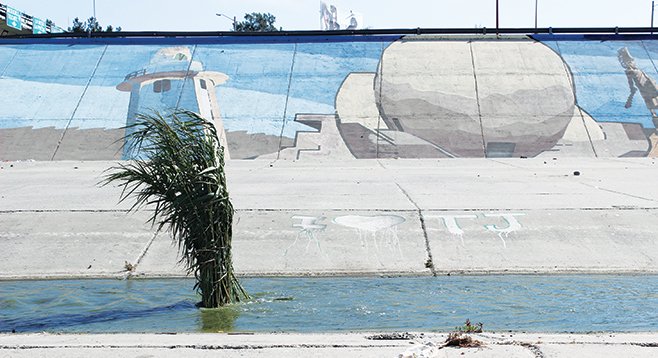
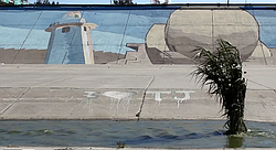
Now, about 100 yards into the canal, it becomes evident that we won’t be making the entire 13-mile trek at this rate. Admoni collapses on a concrete incline and lets out a sigh of relief — his first verbalization since beginning the slog over an hour ago. He wiggles out of his plant suit, shoulders crosshatched with welts. We catch a ride at the nearby Cañon del Padre overpass and, after a quick lunch, Admoni sets out again in front of the recently painted murals of Zona Rio in the Tijuana River canal.
Here, an estimated 1000 homeless, most deported from the U.S., have built makeshift homes along a river that now swirls a sickly green with waste. Some laugh. Others ask what Hollywood is doing in Tijuana (local videographer Bryan Chillian and San Diegan Xavier Vasquez film Admoni’s progress as I scrawl notes and snap photos). Others ask if we are okay, genuinely concerned about our wellbeing, or perhaps our sanity. One threw a rock, which splashed in the cesspool while Admoni kept trudging through eddies of sewage that has undergone preliminary processing by four wastewater treatment plants before being deposited into the canal.
According to Dave Good’s 2012 report, a water-quality study conducted by Volker Luderitz in 2005 found that sources of pollutants in the arroyo include “urban runoff, output from a sewage-treatment plant, slaughterhouse runoff, continual discharge of water laced with organic compounds from the Tecate Brewery, and the release of effluent from maquiladoras (or maquilas), the factories that operate in Mexican free-trade zones.”
“Before [the North American Free Trade Agreement of 1994], people could fish and bathe in the Rio Alamar,” Mendez said. “Before the maquilas came in 1986, you could actually drink the water.”
Residents of the canal can now be seen bathing in the putrid Tijuana River daily, risking exposure to a number of diseases and industrial contaminants. García of Nativ@s de las California sees the pressing humanitarian issues of El Bordo — the threadbare, modern-day Cartolandia of underground hideouts and ersatz structures spanning from the pedestrian bridge to the international border —as yet another reason to avoid canalization.
“There are the social problems of the homeless and the deportees,” he says, “where a fraction of the money that was spent on the channelization could have been more properly spent building shelters and training for these at-risk populations.”
Down in El Bordo, where garbage fires burn in clusters of dilapidated huts, the wastewater gathers in pools to be carried by underground pipes to a treatment plant two miles west on the Mexican border and then under the fence to a facility near Imperial Beach. The South Bay International Wastewater Treatment Plant is equipped to provide secondary treatment for 25 million gallons per day in excess of the treatment that takes place at Tijuana’s wastewater pumping station.
The plant was built as a result of the binational interagency Clean Water Partnership that was formally agreed upon in 1990. The $239-million facility was operational by 1997, but in the meantime, up to 38,000 gallons of sewage poured across the border every day into the Tijuana River Estuary in what wetlands researchers and water district employees call “renegade flows.” Not only did the runoff contain unprocessed human feces, but it also carried household waste and industrial poisons. To this day, excessive rainfall causes minimally processed wastewater to overflow through the flared terminus of the canal into the estuary, which is now the site of the Tijuana River National Estuarine Research Reserve — home to over 370 species of native and migrating birds.
Before the processing plant was built, the 1993 flood caused winter waters to shift the river’s course, destroying a bridge on Hollister Street south of Nestor and effecting an estimated $25 million in damages throughout the valley. In order to avoid future flooding and contamination, the treatment plant completed the South Bay Ocean Outfall in 1999. The 4.5-mile-long, 11-foot-diameter pipe runs underneath the Tijuana River Estuary, depositing treated wastewater 3.5 miles offshore at a depth of 100 feet.
In December 2010, silt-ridden flood waters breached a levee near Hollister Street, causing flooding to a few ranches and necessitating the relocation of 18 horses. No injuries were reported. The estuarine area was not so lucky in 2008, when 4 horses and about a dozen goats drowned. The flood pushed the City of San Diego to petition for an emergency permit from the U.S. Army Corps of Engineers to clear out channels in the valley, including the 1600-foot Smuggler’s Gulch flood-control channel. City crews have been dredging sediment and reinforcing support berms since late 2013. For the past two years, 90 percent of Tijuana’s wastewater has been treated to standards equal to many U.S. cities and higher than those of San Diego.
Remarkably, the moment the sewage disappears underground on the Mexican side of the border, the same sunflowers, fennel bushes, and arundos — the likes of which we haven’t seen since leaving the Alamar forest — sprout from silt deposits on the concrete. It could be wildly symbolic, but it’s more likely that Conagua’s most recent cleaning sweep simply ended at El Bordo, though the sweeps have been used as pretext to displace the river’s residents in the past (with little lasting effect).

Customs and Border Protection officers did not welcome Admoni to the U.S.A. But, “They were very polite. They seemed confused.”
None of us know what to expect when Admoni crosses the line. It feels like a Guantanamo-able offense, but when he finally totters across the vague yellow line demarcating the international border, a Customs and Border Protection Jeep zips over. Its driver asks Admoni what he is doing and directs him back toward Mexico.
“I couldn’t see the line and didn’t know I had even crossed yet,” Admoni later says, “but they were very polite. They seemed confused.”
In a near ceremonious fashion, Admoni teeters back to an outcropping of arundos and slowly removes his cumbersome disguise. A smile comes over his face. And it isn’t the cat-that-ate-the-canary grin that one might expect from somebody who has just party-crashed the entire country dressed in a clump of giant reeds; it’s his usual, calm expression of otherworldly knowing, underscored by what very well may be relief.
“It’s interesting,” Admoni says, overlooking the canal from the pedestrian bridge. “The line is very subtle, but it very much exists. You see that the people in the canal do not cross the line. They have sheds up to the line. In that way it is interesting for me to see how the border is guarded and also how it is manipulating the river. Even though here — especially for the last hundred meters — it is very polluted, but it gets purified. And that is a good symbol for part of the relationship between these two countries, and that is part of what I tried to express with this performance.”
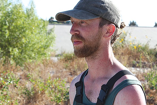
Admoni at the end of the walk. The reeds’ coarse leaves created itchy, irritating welts everywhere.
His face is sunburnt and his torso is ravaged by the blade-like leaves, but Admoni is content. It’s almost strange to see him outside of his plant suit, in which he’s spent much of the day shuffling through shit, silent as a Buddha. But he doesn’t seem to miss it.
“I was kind of leaving it where it belongs,” Admoni says as we walk toward Centro, “but it’s also funny to think that someone might actually use it.”
It’s hard not to laugh at the thought of some poor sap making a run for it in Admoni’s plant suit, waddling with all he’s got due north, cursing those pinche razor-blade leaves and leaving the concrete river far behind as he plows downstream into an estuary overgrown with the invasive reeds he wears.
Here's something you might be interested in.
How to get into U.S. via the Arroyo Alamar
The curious walking reeds of the Tijuana River
How to get into U.S. via the Arroyo Alamar
The curious walking reeds of the Tijuana River
“There’s no real reason to do things like this,” a soft-spoken Yoav Admoni says as he binds fresh-cut reeds to a collapsible laundry hamper with a spool of wire.
It’s a beautiful day in the riparian woods of Arroyo Alamar. Birds chirp their melodies. Squirrels sneak curious glimpses from willow trees. Sunflowers bow to a mild summer breeze. Surrounded by orange smatterings of nasturtium, castor brush, and cachanillas, it’s easy to forget that we are just a stone’s throw away from one of the sketchiest neighborhoods in Tijuana.
Just 40 years ago, Colonia Granja Familiares was an East TJ bastion of ranchos and farmland. Today, thanks to rapid and poorly regulated urbanization, the place is a patchwork of industrial blocks and makeshift shanties surrounding the few remaining miles of Arroyo Alamar, which serves as a dumping ground for the adjacent impoverished communities.
“All I’m trying to do is investigate how green spaces reflect political conflict,” the Israeli performance artist says, “so I focused on the Tijuana River as a mirror of the political conflict in Tijuana and also between Mexico and the U.S.”
Admoni’s goal? To wade west 13 or so miles from the Arroyo Alamar, into the northwest flowing Tijuana River canal, through the deportee purgatory of El Bordo, and clear across the border to the U.S.
Yoav Admoni begins the walk (that’s him in the plant suit, left).
Making modifications
Oh, and he’ll be dressed like a plant.
“I’m always waiting for people to think that I’m being totally irrational, but people always respond very positively and in some bizarre way understand the logic of doing the thing,” Admoni told me a few nights prior at a bar in Centro. “Or at least they pretend to.”
And while the idea of a foreigner just waltzing into America wearing a cloak of regional flora may sound audacious, Admoni notes: “For me the most interesting part is the meeting of this image with other plants in the river. It’s not about crossing the border. It’s about describing the movement of the water and asking, ‘What is a river in this context?’”
As the third installment in his Threesome with Nature thesis project for the Bauhaus University in Weimar, Germany, “Plant Migration” was initially set to start at the base of the Abelardo L. Rodríguez Dam about 6.5 miles southwest. The reservoir feeds a tributary that merges with Arroyo Alamar to become the Tijuana River canal about 4 miles west of where we stand. But, while the Arroyo las Palmas waterway from the dam is completely canalized, Arroyo Alamar still has about two miles of its natural ecology intact before becoming the Tecate River upstream to the east, which crosses south from Barrett Lake, Lake Morena, and the headwaters of Cottonwood Creek in the Laguna Mountains. The contrast of countryside and concrete drew Admoni to Arroyo Alamar.
But even this rare green space (Tijuana has 0.28 square meter per person; San Diegans boast about 40) is doomed to be reduced to a concrete ditch. On a February 13 Milenio Radio broadcast, Eduardo Ledesma Romo, the regional delegate of Conagua (the national water commission), stated that the canalization of Arroyo Alamar was 75 percent complete and that the final three kilometers would be developed as planned following a contract bid. As reported by the Reader’s Dave Good (“Showdown on the Rio Alamar,” September 5, 2012), the remaining floodplain will then be filled and graded to make way for a new vehicle thoroughfare.
When the $47-million Alamar lining project was launched in May 2011, Conagua said the project would not only bolster the economy by promoting development and increasing property values, but it would also save lives. José Luis Luege, Conagua’s director at the time, claimed that canalizing the Alamar would protect 40,000 residents and prevent squatters from constructing shacks in the floodplain. The Alamar, like all waterways in Mexico, is under federal jurisdiction. As such, a Conagua document states that the region “has historically been one of the areas of the city most susceptible to unregulated settlements, due to the absence of control and supervision inside a federal zone within a municipality.”
In fact, squatters have lived along the river since the 1940s. Until the 1970s, the settlement of up to 25,000 residents was known as Cartolandia, named after the scavenged cardboard cartons used to construct the shanties.
Professor Jorge Mancilla, a graduate of Neurobiology at UCSD and England’s University of Cambridge, reported his first-hand account of the removal of Cartolandia to the Reader in 2002 (“This Isn’t the Same Country, This Isn’t the Same Town,” October 10, 2002).
“For decades there had been this squatters’ neighborhood in the Tijuana riverbed right up near the border,” Mancilla said. “Hundreds, maybe thousands, of shacks of the poorest migrants…. Well, for a ‘new Tijuana,’ [part of a plan drafted in Mexico City in order to ‘Mexicanize’ Tijuana] this was intolerable. The land was very valuable. It was flat and there was little flat land in Tijuana to build on. There was this plan to cement in the riverbed and put in flood control. So, in November 1973, the government went in with bulldozers and soldiers and wiped out Cartolandia. Leveled it to the ground. The refugees from Cartolandia went a little east and took the land that became Tierra y Libertad. That’s the story. Part of what was Cartolandia is where the Tijuana Cultural Center now stands.”
Regardless, an April, 2012 dispatch from El Sol de Tijuana asserted that Cartolandia still existed in Arroyo Alamar, where hundreds of shanties were slapped together with whatever material was available. These settlements have since been eradicated by the eastward canalization of the Alamar, with an estimated 5000 residents displaced in the process.
These memories still fresh in their minds, over 300 demonstrators — local families toting banners and strumming Son Jarocho folk tunes — marched along Arroyo Alamar a few days after Conagua’s radio broadcast in a gesture of solidarity that follows a three-year dialogue with state and federal authorities to stop the canalization of the creek. But it’s not just a handful of concerned citizens who have taken an interest in the area. At least 14 nonprofit organizations have also dedicated themselves to defending the area. One of them is Yo Soy el Alamar.
Project coordinator Jorge Calderón points out the pathways that he and his team sculpted throughout the woods while Admoni harvests more reeds and silently weaves them onto his basket.
“We are using what is here — tires, rocks, garbage — to make the land more beautiful,” Calderón says. “It’s for everybody: the rich, the poor, the homeless, and people with homes. We have only three kilometers of Alamar left, so we want to preserve it for people to take walks, have a carne asada, or dance, if they would like to.”
In addition to an abundance of plant life, Arroyo Alamar is home to several species of wildlife, some of which are classified as threatened or protected. Regardless, the creek and its surrounding ecology are slated to be sold to the highest-bidding contractor as soon as possible.
“Concrete is death,” Calderón says, “and you can see it in the change from nature to a channel to a water-treatment plant to an estuary once the river crosses the border.”
In fact, as Dr. Ian Malcolm once famously stated, “Life, uh… finds a way.” A quick search on Google Earth reveals a canal full of flora, albeit to a much lesser degree than what one finds in Alamar forest. The images, probably taken around 2012, show just how far canalization has come (for reference, the canal now begins about 800 meters west of the words “Zona Ecológica Alamar”) and how much riparian ecology was destroyed in the process. Furthermore, Conagua performs regular sweeps of the canal, removing all plants and garbage with bulldozers.
César García Valderrama, program director at Nativ@s de las Californias (a nonprofit focused on the conservation of natural habitats in Baja), stresses the gravity of the conflict.
“The forest is a truly important place regionally, as there are no riparian corridors left in urban Tijuana. The channelization of the Tijuana River destroyed one of the most important riparian flyways in Pacific North America. It was a true bio-diverse haven.”
Ana Elena Espinoza López , director general of CEUSS (Baja California’s center for sustainability, environment, and development), says the surrounding ecosystem and farmland will be squelched out of existence within five years if the remainder of Arroyo Alamar is canalized.
Rene Peralta, director of Woodbury University Graduate School of Architecture, Landscape + Urbanism, and his class offered an alternative that would preserve and even increase green spaces in Tijuana.
“During our research on the restoration of urban rivers, we visited Los Angeles and met with colleagues and the organizations involved in the efforts to bring back the L.A. River as a community amenity,” Peralta says. “We learned about the different ways to control flooding and still have an open and natural river that can serve as public space. After our visit, we continued to look at other cities in Spain, Korea, and the U.S. and began a six-week design studio with students from Washington University in St. Louis.”
As a result, Peralta and his students developed a two-part proposal for the reinvention of Arroyo Alamar.
“One was to actually propose a new way of channelizing the river through a more natural and expanded cross section (using less concrete, more stepped paths, and leaving as much of the local flora as possible). Since the Alamar is a seasonal river, the design also included, where possible, the designation of areas for recreation and leisure in order to create public spaces for the adjacent communities, as the Alamar River flows through where nearly half of the population of the city resides. The other approach was not as ideal but looked at the canyons that feed into the Alamar and transforming them into clean, linear parks that people use to move up and down the Tijuana topography while at the same time helping to reduce wastewater and trash deposits into the Alamar, which then connects to the Tijuana River and ends up in the Pacific Ocean.”
In a recent interview with Milenio, Peralta acknowledged that work would be necessary but called it “a pity that they are considering the project as if we were doing it 30 or 40 years ago, only thinking the singular logic of putting concrete on the problem and that’s it, like sweeping garbage under the rug.”
A proposal similar to Peralta’s, developed by San Diego State University civil engineering professor Dr. Victor Miguel Ponce and his team, has already been approved by Mexican academia and officials, García of Nativ@s de las Californias notes. The proposal re-envisions the canal as a public space divided into nature parks, recreation areas, green houses, and equestrian zones.
“The project that should have been developed was the ecological project designed by SDSU,” García says. “Yet, for reasons that have never been clear, Mexican authorities decided to cancel that project and implement an archaic and unsustainable method.”
Paul Ganster, director of the Institute for Regional Studies of the Californias at San Diego State University, noted in a 2012 U-T San Diego report that, “Development pressure and the desire for immediate profit is so strong in an urbanized place like Tijuana that it’s quite difficult to resist those forces.”
Admoni’s plant suit is finished now. It’s about eight feet tall, weighs maybe 60 pounds, and is so dense you would never guess it hides a stoic young man from Tel-Aviv strapping the thing to his shoulders with improvised suspenders. The comical ensemble is made out of so-called giant reeds, or arundo donax, an invasive species native to Eastern Asia that was first planted in California in the 1820s. The arundo was originally used for erosion control in the L.A. basin and proves useful in the construction of many things, including fishing poles, musical instruments, and, fittingly, walking sticks.
Video:
Reed Walk
Yoav Admoni constructed a suit of invasive reeds over a collapsible laundry hamper and wore it from the riparian creek of Arroyo Alamar (where the reeds were harvested) and into the beginnings of the Tijuana River Canal in east TJ.
“I had a long discussion with myself about whether to use a native or invasive species,” Admoni says. “I felt weird about cutting down a native species, which can be kind of rare. I also liked the idea of an invasive species invading the U.S.”
Inside the suit, the reeds’ coarse leaves act as dull razors on Admoni’s skin, not fully lacerating his exposed neck and shoulders, but creating itchy, irritating welts everywhere. Wearing nothing but fishing waders, a baseball cap, and his shroud of vegetation, he takes his first tentative steps in the river. The wet rocks are slippery, and he fumbles to keep the weighty guise upright. On the riverbank, cattails and datura blossoms grow among old tires, paint buckets, and abandoned coolers. Admoni shuffles slowly down the creek, his pace both cautious and contemplative.
“I mainly want this thing to hold up, and it would be nice to have the ability to take a break at least once,” he said prior to donning his suit and entering the creek. “Sometimes you want nothing to happen, in a way...like authority reaction or whatever. But it also can teach you a lot, how the authorities treat these kinds of actions. For me, the main thing is to create the image and walk with it and see what happens. I don’t know what will happen at the border. I don’t know what will happen when people see this. But that’s part of the interest. It’s trying to understand what will happen because of this image, so I cannot foresee the outcome of it. I don’t want to get arrested. I don’t want to lose my tourist visa to the U.S. or whatever, but it could be.”
It takes nearly an hour to follow the clear, slow-moving creek about 50 yards to the beginning of the canal, a shallow concrete passage that deposits maybe 50 yards later into a vast channel that looks like the Danny/Leo race scene in Grease, which was actually filmed in the Los Angeles River canal.
Just like Los Angeles, Tijuana first canalized its namesake river in response to a flood. Exercising his executive powers, former Baja California governor Milton Castellanos Everardo constructed the first concrete barriers along the river after a 1972 flash flood wiped out riverside housing and left the dense urban floodplain swamped. The river was subsequently relegated to become a wastewater conduit, which went on to include Arroyo Alamar to the southeast with its canalization beginning in 2011. Now, the sewage starts only steps after the natural creek of Alamar ends.
Despite the history, García of Nativ@s de las Californias argues that potential floods are not a legitimate reason to canalize the rest of Arroyo Alamar.
“Flooding is totally infrequent in the Alamar because we have not had enough water for several decades. Yet, if flooding was really one of the reasons for the concrete, the authorities would have never authorized the creation of the Ribera del Bosque neighborhood [a recent sprawl of tract housing], which is right on the floodplain next to the Alamar forest.”
Does the development of Ribera del Bosque indicate that the area is not a hazardous floodplain in the eyes of officials, or could there be other forces at work?
“According to the law, no one can build a house or any building in a river due to security issues,” says Antonio Oceguera Figueroa, who worked on the first phase of the Tijuana River’s canalization from the border to the railway bridge. “Specifically, not in the bed of a river or within its floodable area, because it is public property and cannot be bought and sold.”
Oceguera says that, during his time working on the Tijuana River canal, residents of floodable areas such as parts of Cartolandia were evicted and placed in two housing developments, Fraccionamiento 70/76 and Sánchez Taboada.
“This was a sort of compensation to avoid social conflicts, not an effort to enforce land-use regulations. I suppose that the situation is no different in the Alamar. In accordance with an agreement between Mexico and the United States, Mexico is supposed to maintain the waters of the Tijuana River and the Arroyo Alamar up to the international border at a certain rate so as not to cause any damage in the case of a flood, and that determined the choice to build the wide canal in the first phase. I don’t know if canalizing a wetland forest would have an impact, probably from the ecological point of view, but the politicians yearn for contracts of this type because it gives them the land to sell, and that has certainly been happening since before the project was announced. It’s just one of the swindles typical of corrupt politicians in any country.”
Development or not, flooding remains a problem in Tijuana, which has endured about 15 deluges of varying severity since 1928. However, many floods take place far from the river itself, owing to overpopulated canyons and poor drainage (Tijuana’s sewage system was designed over 40 years ago with a population of 100,000 in mind). One such flood, the worst in Tijuana’s history, happened in January of 1993, when 14 residents were killed and another 4000 made homeless. All of this was caused by two inches of rain in as many days.
Though the flood of ’93 caused extensive property damage, the deadliest occurred in the winter of 1980, when more than 100 illegal residents of the canal drowned after Mexican officials opened the gates of Rodriguez Dam in response to severe rains. Over 25 bodies washed up from Imperial Beach to Coronado, in addition to an unreported number south of the border. The deluge saw the highest flood flows in the Tijuana River in over 60 years.
Now, about 100 yards into the canal, it becomes evident that we won’t be making the entire 13-mile trek at this rate. Admoni collapses on a concrete incline and lets out a sigh of relief — his first verbalization since beginning the slog over an hour ago. He wiggles out of his plant suit, shoulders crosshatched with welts. We catch a ride at the nearby Cañon del Padre overpass and, after a quick lunch, Admoni sets out again in front of the recently painted murals of Zona Rio in the Tijuana River canal.
Here, an estimated 1000 homeless, most deported from the U.S., have built makeshift homes along a river that now swirls a sickly green with waste. Some laugh. Others ask what Hollywood is doing in Tijuana (local videographer Bryan Chillian and San Diegan Xavier Vasquez film Admoni’s progress as I scrawl notes and snap photos). Others ask if we are okay, genuinely concerned about our wellbeing, or perhaps our sanity. One threw a rock, which splashed in the cesspool while Admoni kept trudging through eddies of sewage that has undergone preliminary processing by four wastewater treatment plants before being deposited into the canal.
According to Dave Good’s 2012 report, a water-quality study conducted by Volker Luderitz in 2005 found that sources of pollutants in the arroyo include “urban runoff, output from a sewage-treatment plant, slaughterhouse runoff, continual discharge of water laced with organic compounds from the Tecate Brewery, and the release of effluent from maquiladoras (or maquilas), the factories that operate in Mexican free-trade zones.”
“Before [the North American Free Trade Agreement of 1994], people could fish and bathe in the Rio Alamar,” Mendez said. “Before the maquilas came in 1986, you could actually drink the water.”
Residents of the canal can now be seen bathing in the putrid Tijuana River daily, risking exposure to a number of diseases and industrial contaminants. García of Nativ@s de las California sees the pressing humanitarian issues of El Bordo — the threadbare, modern-day Cartolandia of underground hideouts and ersatz structures spanning from the pedestrian bridge to the international border —as yet another reason to avoid canalization.
“There are the social problems of the homeless and the deportees,” he says, “where a fraction of the money that was spent on the channelization could have been more properly spent building shelters and training for these at-risk populations.”
Down in El Bordo, where garbage fires burn in clusters of dilapidated huts, the wastewater gathers in pools to be carried by underground pipes to a treatment plant two miles west on the Mexican border and then under the fence to a facility near Imperial Beach. The South Bay International Wastewater Treatment Plant is equipped to provide secondary treatment for 25 million gallons per day in excess of the treatment that takes place at Tijuana’s wastewater pumping station.
The plant was built as a result of the binational interagency Clean Water Partnership that was formally agreed upon in 1990. The $239-million facility was operational by 1997, but in the meantime, up to 38,000 gallons of sewage poured across the border every day into the Tijuana River Estuary in what wetlands researchers and water district employees call “renegade flows.” Not only did the runoff contain unprocessed human feces, but it also carried household waste and industrial poisons. To this day, excessive rainfall causes minimally processed wastewater to overflow through the flared terminus of the canal into the estuary, which is now the site of the Tijuana River National Estuarine Research Reserve — home to over 370 species of native and migrating birds.
Before the processing plant was built, the 1993 flood caused winter waters to shift the river’s course, destroying a bridge on Hollister Street south of Nestor and effecting an estimated $25 million in damages throughout the valley. In order to avoid future flooding and contamination, the treatment plant completed the South Bay Ocean Outfall in 1999. The 4.5-mile-long, 11-foot-diameter pipe runs underneath the Tijuana River Estuary, depositing treated wastewater 3.5 miles offshore at a depth of 100 feet.
In December 2010, silt-ridden flood waters breached a levee near Hollister Street, causing flooding to a few ranches and necessitating the relocation of 18 horses. No injuries were reported. The estuarine area was not so lucky in 2008, when 4 horses and about a dozen goats drowned. The flood pushed the City of San Diego to petition for an emergency permit from the U.S. Army Corps of Engineers to clear out channels in the valley, including the 1600-foot Smuggler’s Gulch flood-control channel. City crews have been dredging sediment and reinforcing support berms since late 2013. For the past two years, 90 percent of Tijuana’s wastewater has been treated to standards equal to many U.S. cities and higher than those of San Diego.
Remarkably, the moment the sewage disappears underground on the Mexican side of the border, the same sunflowers, fennel bushes, and arundos — the likes of which we haven’t seen since leaving the Alamar forest — sprout from silt deposits on the concrete. It could be wildly symbolic, but it’s more likely that Conagua’s most recent cleaning sweep simply ended at El Bordo, though the sweeps have been used as pretext to displace the river’s residents in the past (with little lasting effect).
Customs and Border Protection officers did not welcome Admoni to the U.S.A. But, “They were very polite. They seemed confused.”
None of us know what to expect when Admoni crosses the line. It feels like a Guantanamo-able offense, but when he finally totters across the vague yellow line demarcating the international border, a Customs and Border Protection Jeep zips over. Its driver asks Admoni what he is doing and directs him back toward Mexico.
“I couldn’t see the line and didn’t know I had even crossed yet,” Admoni later says, “but they were very polite. They seemed confused.”
In a near ceremonious fashion, Admoni teeters back to an outcropping of arundos and slowly removes his cumbersome disguise. A smile comes over his face. And it isn’t the cat-that-ate-the-canary grin that one might expect from somebody who has just party-crashed the entire country dressed in a clump of giant reeds; it’s his usual, calm expression of otherworldly knowing, underscored by what very well may be relief.
“It’s interesting,” Admoni says, overlooking the canal from the pedestrian bridge. “The line is very subtle, but it very much exists. You see that the people in the canal do not cross the line. They have sheds up to the line. In that way it is interesting for me to see how the border is guarded and also how it is manipulating the river. Even though here — especially for the last hundred meters — it is very polluted, but it gets purified. And that is a good symbol for part of the relationship between these two countries, and that is part of what I tried to express with this performance.”
Admoni at the end of the walk. The reeds’ coarse leaves created itchy, irritating welts everywhere.
His face is sunburnt and his torso is ravaged by the blade-like leaves, but Admoni is content. It’s almost strange to see him outside of his plant suit, in which he’s spent much of the day shuffling through shit, silent as a Buddha. But he doesn’t seem to miss it.
“I was kind of leaving it where it belongs,” Admoni says as we walk toward Centro, “but it’s also funny to think that someone might actually use it.”
It’s hard not to laugh at the thought of some poor sap making a run for it in Admoni’s plant suit, waddling with all he’s got due north, cursing those pinche razor-blade leaves and leaving the concrete river far behind as he plows downstream into an estuary overgrown with the invasive reeds he wears.
Comments