Here's something you might be interested in.
Ask a Hipster — Advice you didn't know you needed
Big Screen — Movie commentary
Blurt — Music's inside track
Booze News — San Diego spirits
Classical Music — Immortal beauty
Classifieds — Free and easy
Cover Stories — Front-page features
Drinks All Around — Bartenders' drink recipes
Excerpts — Literary and spiritual excerpts
Feast! — Food & drink reviews
Feature Stories — Local news & stories
Fishing Report — What’s getting hooked from ship and shore
From the Archives — Spotlight on the past
Golden Dreams — Talk of the town
The Gonzo Report — Making the musical scene, or at least reporting from it
Letters — Our inbox
Movies@Home — Local movie buffs share favorites
Movie Reviews — Our critics' picks and pans
Musician Interviews — Up close with local artists
Neighborhood News from Stringers — Hyperlocal news
News Ticker — News & politics
Obermeyer — San Diego politics illustrated
Outdoors — Weekly changes in flora and fauna
Overheard in San Diego — Eavesdropping illustrated
Poetry — The old and the new
Reader Travel — Travel section built by travelers
Reading — The hunt for intellectuals
Roam-O-Rama — SoCal's best hiking/biking trails
San Diego Beer — Inside San Diego suds
SD on the QT — Almost factual news
Sheep and Goats — Places of worship
Special Issues — The best of
Street Style — San Diego streets have style
Surf Diego — Real stories from those braving the waves
Theater — On stage in San Diego this week
Tin Fork — Silver spoon alternative
Under the Radar — Matt Potter's undercover work
Unforgettable — Long-ago San Diego
Unreal Estate — San Diego's priciest pads
Your Week — Daily event picks
Map-makers did the best they could during WWII
Censorship can be a quirky business.
Detail of military version of Auto Club map
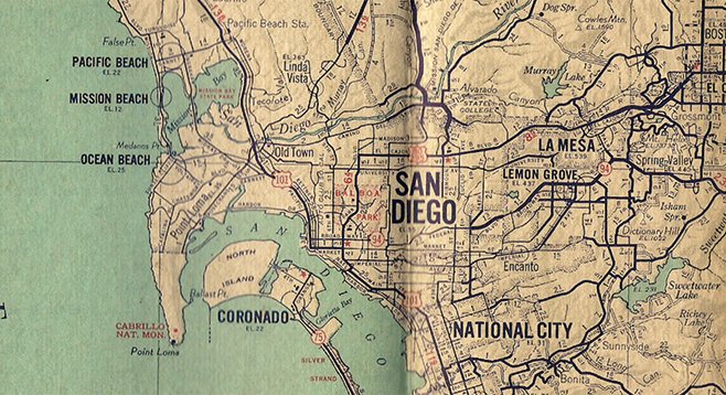
Unfold a 1944 map of San Diego County by the Automobile Club of Southern California and look for Lindbergh Field, the port, Point Loma’s Naval Training Center or Marine Corps Depot. You won’t find them. Nor can you locate Fort Rosecrans, Camp Kearny, Navy Hospital and the Ship Repair Base, Camp Pendleton, or the 29 other military installations in the region nicknamed “Defense City No. 1” during World War II.
Automobile Club of Southern California 1944
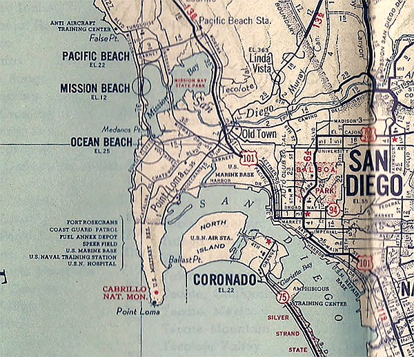
Now, unfold a second 1944 map of San Diego County by the Auto Club. It has the same cover and legend box as the first, but every airfield, military base and pier is clearly marked and indexed.
You’ve stumbled across a little-known relic of World War II on the American home front. In an era when Google Earth and GPS offer instant mapping worldwide, the idea of map censorship in the United States comes off as ludicrous. Yet, 72 years ago, following the December 7, 1941, Japanese attack on Pearl Harbor, map masking — as the practice was called — became official wartime doctrine for road maps and others issued in the U.S. for non-military use.
Under a voluntary code distributed by the Office of Censorship in early 1942, map-makers along with journalists and other purveyors of information were asked to remove details that would disclose “locations of ammunition dumps or other restricted Army or Navy areas” along with “the locations of forts and other fortifications.” The code was self-policing: media were to ask themselves, “Is this information that I would like to have if I were the enemy?” and act accordingly, says historian Michael Sweeney, whose book Secrets of Victory examines the bureau.
For the Auto Club, which worked closely with West Coast defense authorities to craft maps for the military, its cartographers were often able to print two sets of maps: fully detailed renderings of the state, counties, and cities for the armed forces; and censored editions for civilians — thus the contrasting 1944 San Diego County versions.
For other map-makers, especially those producing consumer maps for gasoline brands to distribute, masking proved inconsistent, quirky, and even darkly humorous.
Most U.S. oil company road maps were drawn by H.M. Gousha of Chicago/San Jose, by Rand McNally of Chicago, or by General Drafting of New York. These often colorful maps had exploded in popularity during the 1930s with the growth in motoring. America’s December 1941 entry into the war, however, generated wartime paper shortages, gasoline rationing, and a crimped market for tourism. The companies nevertheless issued 1942 maps for most states and cities, as they had already begun production, but not until 1946 did updated maps again appear broadly. (Maps from 1942 were occasionally reprinted during later war years.)
So, while the Auto Club could derive ongoing civilian issues from its military versions, the major map companies had to choose what to eliminate on each of their prewar issues within a one-time span of a few months. Depending on the cartographer, their wartime maps of the same area differed as to which, if any, airfields, ports, dams, oil fields, military bases, and related facilities disappeared. Even among maps drawn by the same company, the level of masking varied based on the gas-brand label.
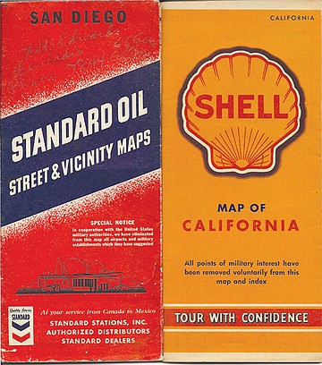
Gousha’s 1942 Standard Oil street map for San Diego came with a “special notice” on the cover: “In cooperation with the United States military authorities, we have eliminated from this map all airports and military establishments which they have suggested.” The map included nighttime driving restrictions from the U.S. Army Western Defense Command: “All of San Diego and coastal area is under dim-out regulations from sunset to sunrise. 20 mile speed limit under dim-out conditions….headlights (not more than 2) limited to 250 beam candle power each.”
Inside, cartographers scrubbed away Lindbergh Field, the Naval Training Center, and the Marine Corps Recruit Depot, leaving a blank swath of land along much of the bayfront from Pacific Highway west to Rosecrans Street. However, they kept prewar map labeling of Fort Rosecrans and the U.S. Military Cemetery, as well as Coronado’s North Island, though it appeared undeveloped, masking the Naval Air Station infrastructure and runways. Miramar remained as a road marker point along Highway 395 in a sea of open space, where in actuality three military camps — Kearny, Miramar, and Elliott — abutted one another.
Map covers noting removal of military locations
Gousha’s San Diego map for Shell Oil noted on its cover that “All points of military interest have been removed voluntarily from this map and index” and in addition to the deletions on its Standard map, it dropped Fort Rosecrans and the cemetery as well. Rand McNally’s Union Oil San Diego map went the furthest and also took out the Naval Hospital, all names of downtown piers, the Santa Fe Depot (Union Station at the time), and the downtown YMCA for military personnel. To look at the Union Oil map, it was as if the U.S. Navy, Army, Coast Guard, and Marine Corps had never existed in San Diego, at the time a quintessential military town. In spring 1944, the Auto Club issued a sanitized version of a large San Diego city map that the military had earlier requested. The civilian map included the train station and Naval Hospital, but otherwise its masking paralleled that of Union Oil.
Inconsistencies of censorship also cropped up among WWII maps for California, Los Angeles, and San Francisco.
Every wartime Shell Oil map by Gousha nationwide included the “voluntary removal” label, and Shell’s California map was thoroughly censored. Airports statewide vanished. San Diego lost its military presence. Absent in the Bay Area was the dozen forts and bases around San Francisco’s Presidio military reservation and Golden Gate, and all ship repair bases. In and around Los Angeles, Fort MacArthur and Terminal Island in the Long Beach–San Pedro area were gone, as well as the locations of Southern California oil fields prominent on prewar road maps. Bases throughout the Central Coast and Valley disappeared.
Yet Gousha’s 1942 Standard Oil California map with its own special cover notice included the Presidio, its neighbor Fort Winfield Scott, and nearby Fort Mason — a huge supply and troop embarkation depot — as well as Fort MacArthur and Terminal Island, Camp Haan in Riverside County, camps Roberts and Hunter-Liggett along the Central Coast, and Fort Rosecrans and Camp Lockett in San Diego. Rand McNally’s Union Oil California map listed camps Roberts and Haan, and — while masking the Presidio — inexplicably kept forts Point and Barry at the mouth of the Golden Gate. State and regional maps by Gousha and the Auto Club dropped the March Field Army air base near Riverside but not the March Field stop of the Santa Fe Railroad. Rand McNally instead labeled only the nearby Allesandro rail siding.
Gousha and Rand McNally state maps maintained Parker and Imperial dams along the Colorado River as well as the aqueduct to the Los Angeles metropolitan area. Auto Club maps masked them and its Nevada coverage dropped Boulder (Hoover) Dam. A Thomas Brothers 1943 California map stripped out everything civilian and military of possible enemy interest except, for reasons unknown, forts Baker and Barry around the Golden Gate and Mare Island Naval Yard inside San Francisco Bay.
Gousha’s 1942 Standard Oil city map for San Francisco included the Presidio and forts Scott and Mason, while on Gousha’s Shell map they disappeared, even though the front covers of both proclaimed their adherence to national defense guidelines. Rand McNally’s Union Oil San Francisco map featured a cover cartoon of an Army officer and a sailor peering at a city map devoid of military bases and airports. Then again, an independent 1943 city guide for visitors, “Flavor of San Francisco,” detailed the forts in and around the Presidio, the vast Kaiser shipyards and other military points of interest absent from most maps. A 1942 Auto Club civilian map of the Monterey Bay region masked Fort Ord and related facilities, but a 1943 map of the same area from the California State Automobile Association displayed Fort Ord, airports, and other sensitive landmarks.
While obviously messy, the varying levels of map censorship for the California region indicate at least a good-faith effort on the part of map-makers to carry out the voluntary guidelines. The 1945 official history of the Western Defense Command makes clear the government’s fears after Pearl Harbor, both of a West Coast invasion and sabotage of military bases and aircraft plants. In February 1942, a Japanese submarine lobbed shells at oil facilities at Santa Barbara and there were numerous false alarms statewide in the months immediately after December 7. (The Auto Club posted coastal highway signs for the military warning residents of the danger of isolated beach landings by enemy saboteurs.) The threat of air attack or invasion did not end completely until after the U.S. retook Japanese-held islands in the Aleutian chain in mid-1943, although it diminished following the June 1942 defeat of a large Japanese invasion force off Midway Island west of Hawaii.
There was close cooperation between the Auto Club of Southern California and the Western Defense Command, documented by the organization in 1945. The liaisons began in June 1941, when coastal defense planning accelerated in the face of increasing concerns about a Pacific conflict, and kicked into high gear after Pearl Harbor. The Auto Club supplied the military with 231,000 total maps, including more than 11,000 “blue line” large-scale original copies of all Southern California counties, the city of San Diego, and the Los Angeles–Long Beach Harbor, among others. The voluntary censorship is hinted at in the club’s description of drafting work that followed field surveys for wartime maps: “culture and name deletions and additions.”
It’s logical to assume that the censored civilian versions of Auto Club wartime maps reflected the best judgments of the Western Defense Command’s mapping engineers who worked hand-in-hand with club cartographers. But even the Auto Club could slip up. Its civilian map for Kern County dropped locations such as the U.S. Army Bombing Range near Mojave, the vast Ten Sections Oil field, and Taft Airport. Yet the three places with their map coordinates remained in the index copied from the military version. Similarly, the censored San Luis Obispo County map dropped the Army’s sprawling Camp Roberts facility, but it was still indexed.
What about the rest of the country? There were no other organizations comparable to the Auto Club of Southern California producing military and civilian versions of maps. Oil-brand maps for other states differed widely in their degree of masking, just as they did for California. Only Gousha’s Shell maps uniformly scrubbed airports and military bases nationwide and noted it for consumers — from Oregon and Idaho through Ohio to New York, Boston, and Maine. Standard Oil and Texaco maps for regions outside of California carried labels only warning of paper shortages and asking consumers to save maps for future use.
In the Northwest, Gousha’s maps for Standard and Associated Oil eliminated most war-related facilities, probably in recognition of the defense vulnerability of Oregon and Washington. In the Midwest, its 1942 Illinois map for Cities Service masked bases and airfields, but its Chicago city map for Phillips Petroleum did not. Gousha’s Shell map for Kentucky/Tennessee was scrubbed but an otherwise identical map for PanAm Petroleum was not.
Rand McNally eliminated important Army and Navy bases in and around Philadelphia on its 1942 Pennsylvania map for Sinclair Oil but left those facilities on its Philadelphia city map for Gulf Oil. Its 1942 Standard Oil maps for Nebraska, Minnesota, and Michigan retained bases and fields, and the Detroit inset map with the Michigan issue detailed key industrial plants such as Ford’s River Rouge, which was churning out engines for tanks and bombers.
Nationally, given the many map masking variations, it’s unclear how or to what extent Gousha, Rand McNally, and other oil-brand publishers communicated with the military or the Censorship Office about the process, especially in the case of General Drafting Co.
General Drafting produced maps for for Esso, Mobil, and others. On all of its 1942-dated maps, military bases, airports, and related facilities were left intact — including those for New England, New Jersey, New York, and New York City, North/South Carolina, Georgia/Alabama, Kentucky/Tennessee, and Florida. Each state hosted critical military facilities. And its 1942 Esso map of Washington DC seemingly contravened all censorship guidelines. The issue identified every military facility, including the Army War College, the War Department building, the site for the New War Department building (the Pentagon), as well as civilian and military airports, the Washington Naval Yard, and fuel-oil refineries and wharves along the Potomac River. But this map also included the German embassy near Thomas Circle and the Japanese embassy along Massachusetts Avenue just south of Rock Creek Park, even though the embassies had been quickly shuttered in early December 1941 following Pearl Harbor. This detail seems to indicate that at least some 1942 General Drafting maps had been completed and printed by the time America entered the war but distributed after hostilities began.
Admittedly, the threat of invasion or bombing along the East Coast or in interior regions of the country was never realistic, though acts of sabotage were attempted and German submarines wreaked havoc on Atlantic Coast shipping for much of 1942. Still, the DC map adds a bit of dark humor to the entire masking enterprise. How seriously could wartime map censorship be taken if the heart of the nation’s government was mapped to the nth detail and kept available for all to see?
Finally, there is the irony of the Military Map of the United States when juxtaposed with the voluntary censorship code. Prepared annually by Rand McNally beginning in 1941 and issued by the Union Pacific Railroad throughout the war, it pinpointed the location of every military post in the country, along with the post office address and the nearest railroad station — whether that of Union Pacific or another carrier — which served the base. This map was distributed widely to service personnel and their dependents, and to freight shippers along with reminders of how to expedite the movement of goods during a time of maximum stress on the nation’s rail system. It could never have been created without the cooperation of military authorities.
Voluntary censorship. Quirky indeed.
Here's something you might be interested in.
Map-makers did the best they could during WWII
Censorship can be a quirky business.
Map-makers did the best they could during WWII
Censorship can be a quirky business.
Detail of military version of Auto Club map
Unfold a 1944 map of San Diego County by the Automobile Club of Southern California and look for Lindbergh Field, the port, Point Loma’s Naval Training Center or Marine Corps Depot. You won’t find them. Nor can you locate Fort Rosecrans, Camp Kearny, Navy Hospital and the Ship Repair Base, Camp Pendleton, or the 29 other military installations in the region nicknamed “Defense City No. 1” during World War II.
Automobile Club of Southern California 1944
Now, unfold a second 1944 map of San Diego County by the Auto Club. It has the same cover and legend box as the first, but every airfield, military base and pier is clearly marked and indexed.
You’ve stumbled across a little-known relic of World War II on the American home front. In an era when Google Earth and GPS offer instant mapping worldwide, the idea of map censorship in the United States comes off as ludicrous. Yet, 72 years ago, following the December 7, 1941, Japanese attack on Pearl Harbor, map masking — as the practice was called — became official wartime doctrine for road maps and others issued in the U.S. for non-military use.
Under a voluntary code distributed by the Office of Censorship in early 1942, map-makers along with journalists and other purveyors of information were asked to remove details that would disclose “locations of ammunition dumps or other restricted Army or Navy areas” along with “the locations of forts and other fortifications.” The code was self-policing: media were to ask themselves, “Is this information that I would like to have if I were the enemy?” and act accordingly, says historian Michael Sweeney, whose book Secrets of Victory examines the bureau.
For the Auto Club, which worked closely with West Coast defense authorities to craft maps for the military, its cartographers were often able to print two sets of maps: fully detailed renderings of the state, counties, and cities for the armed forces; and censored editions for civilians — thus the contrasting 1944 San Diego County versions.
For other map-makers, especially those producing consumer maps for gasoline brands to distribute, masking proved inconsistent, quirky, and even darkly humorous.
Most U.S. oil company road maps were drawn by H.M. Gousha of Chicago/San Jose, by Rand McNally of Chicago, or by General Drafting of New York. These often colorful maps had exploded in popularity during the 1930s with the growth in motoring. America’s December 1941 entry into the war, however, generated wartime paper shortages, gasoline rationing, and a crimped market for tourism. The companies nevertheless issued 1942 maps for most states and cities, as they had already begun production, but not until 1946 did updated maps again appear broadly. (Maps from 1942 were occasionally reprinted during later war years.)
So, while the Auto Club could derive ongoing civilian issues from its military versions, the major map companies had to choose what to eliminate on each of their prewar issues within a one-time span of a few months. Depending on the cartographer, their wartime maps of the same area differed as to which, if any, airfields, ports, dams, oil fields, military bases, and related facilities disappeared. Even among maps drawn by the same company, the level of masking varied based on the gas-brand label.
Gousha’s 1942 Standard Oil street map for San Diego came with a “special notice” on the cover: “In cooperation with the United States military authorities, we have eliminated from this map all airports and military establishments which they have suggested.” The map included nighttime driving restrictions from the U.S. Army Western Defense Command: “All of San Diego and coastal area is under dim-out regulations from sunset to sunrise. 20 mile speed limit under dim-out conditions….headlights (not more than 2) limited to 250 beam candle power each.”
Inside, cartographers scrubbed away Lindbergh Field, the Naval Training Center, and the Marine Corps Recruit Depot, leaving a blank swath of land along much of the bayfront from Pacific Highway west to Rosecrans Street. However, they kept prewar map labeling of Fort Rosecrans and the U.S. Military Cemetery, as well as Coronado’s North Island, though it appeared undeveloped, masking the Naval Air Station infrastructure and runways. Miramar remained as a road marker point along Highway 395 in a sea of open space, where in actuality three military camps — Kearny, Miramar, and Elliott — abutted one another.
Map covers noting removal of military locations
Gousha’s San Diego map for Shell Oil noted on its cover that “All points of military interest have been removed voluntarily from this map and index” and in addition to the deletions on its Standard map, it dropped Fort Rosecrans and the cemetery as well. Rand McNally’s Union Oil San Diego map went the furthest and also took out the Naval Hospital, all names of downtown piers, the Santa Fe Depot (Union Station at the time), and the downtown YMCA for military personnel. To look at the Union Oil map, it was as if the U.S. Navy, Army, Coast Guard, and Marine Corps had never existed in San Diego, at the time a quintessential military town. In spring 1944, the Auto Club issued a sanitized version of a large San Diego city map that the military had earlier requested. The civilian map included the train station and Naval Hospital, but otherwise its masking paralleled that of Union Oil.
Inconsistencies of censorship also cropped up among WWII maps for California, Los Angeles, and San Francisco.
Every wartime Shell Oil map by Gousha nationwide included the “voluntary removal” label, and Shell’s California map was thoroughly censored. Airports statewide vanished. San Diego lost its military presence. Absent in the Bay Area was the dozen forts and bases around San Francisco’s Presidio military reservation and Golden Gate, and all ship repair bases. In and around Los Angeles, Fort MacArthur and Terminal Island in the Long Beach–San Pedro area were gone, as well as the locations of Southern California oil fields prominent on prewar road maps. Bases throughout the Central Coast and Valley disappeared.
Yet Gousha’s 1942 Standard Oil California map with its own special cover notice included the Presidio, its neighbor Fort Winfield Scott, and nearby Fort Mason — a huge supply and troop embarkation depot — as well as Fort MacArthur and Terminal Island, Camp Haan in Riverside County, camps Roberts and Hunter-Liggett along the Central Coast, and Fort Rosecrans and Camp Lockett in San Diego. Rand McNally’s Union Oil California map listed camps Roberts and Haan, and — while masking the Presidio — inexplicably kept forts Point and Barry at the mouth of the Golden Gate. State and regional maps by Gousha and the Auto Club dropped the March Field Army air base near Riverside but not the March Field stop of the Santa Fe Railroad. Rand McNally instead labeled only the nearby Allesandro rail siding.
Gousha and Rand McNally state maps maintained Parker and Imperial dams along the Colorado River as well as the aqueduct to the Los Angeles metropolitan area. Auto Club maps masked them and its Nevada coverage dropped Boulder (Hoover) Dam. A Thomas Brothers 1943 California map stripped out everything civilian and military of possible enemy interest except, for reasons unknown, forts Baker and Barry around the Golden Gate and Mare Island Naval Yard inside San Francisco Bay.
Gousha’s 1942 Standard Oil city map for San Francisco included the Presidio and forts Scott and Mason, while on Gousha’s Shell map they disappeared, even though the front covers of both proclaimed their adherence to national defense guidelines. Rand McNally’s Union Oil San Francisco map featured a cover cartoon of an Army officer and a sailor peering at a city map devoid of military bases and airports. Then again, an independent 1943 city guide for visitors, “Flavor of San Francisco,” detailed the forts in and around the Presidio, the vast Kaiser shipyards and other military points of interest absent from most maps. A 1942 Auto Club civilian map of the Monterey Bay region masked Fort Ord and related facilities, but a 1943 map of the same area from the California State Automobile Association displayed Fort Ord, airports, and other sensitive landmarks.
While obviously messy, the varying levels of map censorship for the California region indicate at least a good-faith effort on the part of map-makers to carry out the voluntary guidelines. The 1945 official history of the Western Defense Command makes clear the government’s fears after Pearl Harbor, both of a West Coast invasion and sabotage of military bases and aircraft plants. In February 1942, a Japanese submarine lobbed shells at oil facilities at Santa Barbara and there were numerous false alarms statewide in the months immediately after December 7. (The Auto Club posted coastal highway signs for the military warning residents of the danger of isolated beach landings by enemy saboteurs.) The threat of air attack or invasion did not end completely until after the U.S. retook Japanese-held islands in the Aleutian chain in mid-1943, although it diminished following the June 1942 defeat of a large Japanese invasion force off Midway Island west of Hawaii.
There was close cooperation between the Auto Club of Southern California and the Western Defense Command, documented by the organization in 1945. The liaisons began in June 1941, when coastal defense planning accelerated in the face of increasing concerns about a Pacific conflict, and kicked into high gear after Pearl Harbor. The Auto Club supplied the military with 231,000 total maps, including more than 11,000 “blue line” large-scale original copies of all Southern California counties, the city of San Diego, and the Los Angeles–Long Beach Harbor, among others. The voluntary censorship is hinted at in the club’s description of drafting work that followed field surveys for wartime maps: “culture and name deletions and additions.”
It’s logical to assume that the censored civilian versions of Auto Club wartime maps reflected the best judgments of the Western Defense Command’s mapping engineers who worked hand-in-hand with club cartographers. But even the Auto Club could slip up. Its civilian map for Kern County dropped locations such as the U.S. Army Bombing Range near Mojave, the vast Ten Sections Oil field, and Taft Airport. Yet the three places with their map coordinates remained in the index copied from the military version. Similarly, the censored San Luis Obispo County map dropped the Army’s sprawling Camp Roberts facility, but it was still indexed.
What about the rest of the country? There were no other organizations comparable to the Auto Club of Southern California producing military and civilian versions of maps. Oil-brand maps for other states differed widely in their degree of masking, just as they did for California. Only Gousha’s Shell maps uniformly scrubbed airports and military bases nationwide and noted it for consumers — from Oregon and Idaho through Ohio to New York, Boston, and Maine. Standard Oil and Texaco maps for regions outside of California carried labels only warning of paper shortages and asking consumers to save maps for future use.
In the Northwest, Gousha’s maps for Standard and Associated Oil eliminated most war-related facilities, probably in recognition of the defense vulnerability of Oregon and Washington. In the Midwest, its 1942 Illinois map for Cities Service masked bases and airfields, but its Chicago city map for Phillips Petroleum did not. Gousha’s Shell map for Kentucky/Tennessee was scrubbed but an otherwise identical map for PanAm Petroleum was not.
Rand McNally eliminated important Army and Navy bases in and around Philadelphia on its 1942 Pennsylvania map for Sinclair Oil but left those facilities on its Philadelphia city map for Gulf Oil. Its 1942 Standard Oil maps for Nebraska, Minnesota, and Michigan retained bases and fields, and the Detroit inset map with the Michigan issue detailed key industrial plants such as Ford’s River Rouge, which was churning out engines for tanks and bombers.
Nationally, given the many map masking variations, it’s unclear how or to what extent Gousha, Rand McNally, and other oil-brand publishers communicated with the military or the Censorship Office about the process, especially in the case of General Drafting Co.
General Drafting produced maps for for Esso, Mobil, and others. On all of its 1942-dated maps, military bases, airports, and related facilities were left intact — including those for New England, New Jersey, New York, and New York City, North/South Carolina, Georgia/Alabama, Kentucky/Tennessee, and Florida. Each state hosted critical military facilities. And its 1942 Esso map of Washington DC seemingly contravened all censorship guidelines. The issue identified every military facility, including the Army War College, the War Department building, the site for the New War Department building (the Pentagon), as well as civilian and military airports, the Washington Naval Yard, and fuel-oil refineries and wharves along the Potomac River. But this map also included the German embassy near Thomas Circle and the Japanese embassy along Massachusetts Avenue just south of Rock Creek Park, even though the embassies had been quickly shuttered in early December 1941 following Pearl Harbor. This detail seems to indicate that at least some 1942 General Drafting maps had been completed and printed by the time America entered the war but distributed after hostilities began.
Admittedly, the threat of invasion or bombing along the East Coast or in interior regions of the country was never realistic, though acts of sabotage were attempted and German submarines wreaked havoc on Atlantic Coast shipping for much of 1942. Still, the DC map adds a bit of dark humor to the entire masking enterprise. How seriously could wartime map censorship be taken if the heart of the nation’s government was mapped to the nth detail and kept available for all to see?
Finally, there is the irony of the Military Map of the United States when juxtaposed with the voluntary censorship code. Prepared annually by Rand McNally beginning in 1941 and issued by the Union Pacific Railroad throughout the war, it pinpointed the location of every military post in the country, along with the post office address and the nearest railroad station — whether that of Union Pacific or another carrier — which served the base. This map was distributed widely to service personnel and their dependents, and to freight shippers along with reminders of how to expedite the movement of goods during a time of maximum stress on the nation’s rail system. It could never have been created without the cooperation of military authorities.
Voluntary censorship. Quirky indeed.
Comments