Here's something you might be interested in.
Ask a Hipster — Advice you didn't know you needed
Big Screen — Movie commentary
Blurt — Music's inside track
Booze News — San Diego spirits
Classical Music — Immortal beauty
Classifieds — Free and easy
Cover Stories — Front-page features
Drinks All Around — Bartenders' drink recipes
Excerpts — Literary and spiritual excerpts
Feast! — Food & drink reviews
Feature Stories — Local news & stories
Fishing Report — What’s getting hooked from ship and shore
From the Archives — Spotlight on the past
Golden Dreams — Talk of the town
The Gonzo Report — Making the musical scene, or at least reporting from it
Letters — Our inbox
Movies@Home — Local movie buffs share favorites
Movie Reviews — Our critics' picks and pans
Musician Interviews — Up close with local artists
Neighborhood News from Stringers — Hyperlocal news
News Ticker — News & politics
Obermeyer — San Diego politics illustrated
Outdoors — Weekly changes in flora and fauna
Overheard in San Diego — Eavesdropping illustrated
Poetry — The old and the new
Reader Travel — Travel section built by travelers
Reading — The hunt for intellectuals
Roam-O-Rama — SoCal's best hiking/biking trails
San Diego Beer — Inside San Diego suds
SD on the QT — Almost factual news
Sheep and Goats — Places of worship
Special Issues — The best of
Street Style — San Diego streets have style
Surf Diego — Real stories from those braving the waves
Theater — On stage in San Diego this week
Tin Fork — Silver spoon alternative
Under the Radar — Matt Potter's undercover work
Unforgettable — Long-ago San Diego
Unreal Estate — San Diego's priciest pads
Your Week — Daily event picks
Biking the Great Western Loop
This East County route should be on every S.D. cycler's list.
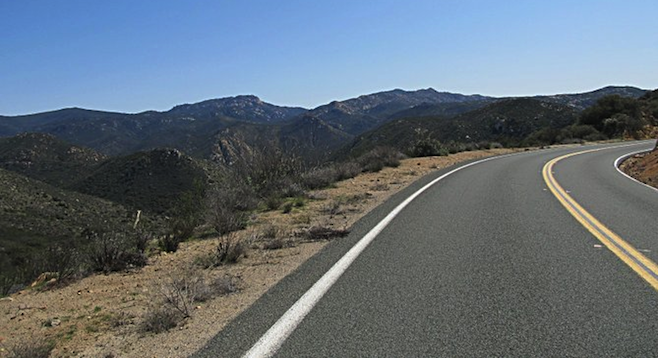
View from Lyons Valley Road, the 42-mile ride's highest point.
A few friends and I went riding East County's Great Western Loop on a clear November morning. The GWL is a popular rural cycling route along Willow Glen, Dehesa, Japatul, Lyons Valley Roads and Jamul Drive that occasions a lot of wild views and elevation gain to keep the masochistic road cyclists painfully happy.
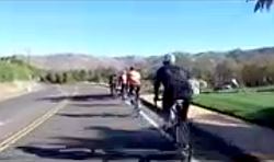
Video:
The Great Western Loop
My friends and I headed off on the relatively flat Willow Glen Road from Rancho San Diego and kept to a tight formation as we made the right turn onto Dehesa Road – right smack into casino traffic. We were grateful for the wide-ish road shoulder, but it was still a relief to finally pass Sycuan Casino and leave most of the speedy cars behind. Of course, the real climbing also starts there, and the stronger guys soon tore up the winding road. Soon I found myself at the tail end of the group, spinning just fast enough to keep the next man in sight as the road climbs four relentless miles up to the intersection with Japatul/Tavern Road.
Turning right on Japatul Road, there was a brief relief with a short downhill run past anorexic-looking Loveland Reservoir before more climbing ensued. The morning grew quite warm as we reached the (in)famous Japatul Wall to the Lyons Valley Road turn off. I'm afraid the Sunrise Powerlink doesn't add much to the view, but it does give a weary cyclist something to shoot for on a long climb. Most of us were nearly out of water by the time we made the right turn onto Lyons Valley Road.
Luckily we were also at the ride's highest point. Much of the rest of the way lies downhill, with quite a spectacular vista of Barrett Lake and Valley along the left side of the road to boot.
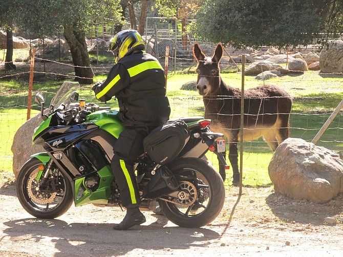
No snack for Black Jack.
A gentle climb took us up to Four Corners (the intersection of Lyons Valley Rd, Honey Springs Rd & Skyline Truck Trail), and, a further mile to the mountain oasis that is the Lyons Valley Trading Post for cold drinks and snacks. Black Jack, the donkey across the road, was trying to eeyore a motorcyclist into feeding him something sweet (left). (He didn't get any treat, by the way. A good thing, considering that the previous donkey there died from diabetes because passerby kept feeding him.)
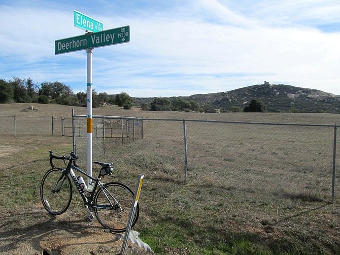
The rest of the guys continued on the GWL while I doubled back to Four Corners and went down Honey Springs Road, past Jacob's prominent red barn to the duck pond, and swung left to explore Deerhorn Valley.
Deerhorn Valley Road is quite a little charmer! From a cyclist's point of view, the mile-long climb is a bit testy at around 8% grade, though there is a bit of view to see along the way. The prominent rocky spire of Eagle's Nest (AKA Bratton's Peak) dominates the right (south) side of the road as Elena Mountain's sugar loaf rocks tantalizes from the upslope on the left.
Deerhorn Valley Road, post-climb. "Secret" castle in the background.
At the crest of the climb (whew! The narrow road seems to so encourage fast driving that I was relieved to be able to pull off for a little breather), the view on the right opens up quite a bit and San Diego's best-kept secret castle is visible in all its glory on the top of the hill.
I had thought about continuing to the end of Deerhorn Valley Road, but the idea of having to climb back up what looked to be an unpleasantly steep grade on what was turning out to be a really warm day proved a deterrent, so I took a left at the second intersection with Elena Lane (it's a half-circle paved lane that cuts Deerhorn Valley Road twice) and did a loop around Mt. Elena's shady pastures instead. Stately old oaks housing bluebirds and white-crowned sparrows, lively horses in fenced-off yards. All within an hour's drive from the city.
Descending back down to the freshly re-paved Honey Springs Road and making the left turn onto the freshly re-paved Highway 94 was a delight – no more potholes to dodge while keeping out of cars' way.
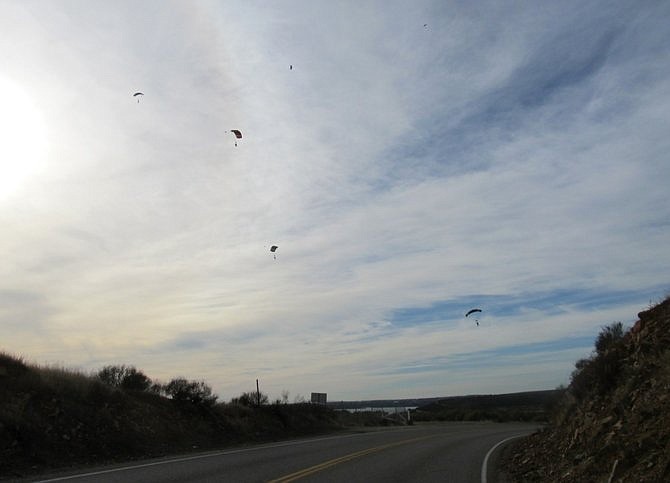
Watching the skydivers from Otay Lakes Road.
I headed west back to town on winding Otay Lakes Road, fighting persistent headwind and hoping that my neon-green jacket and flashing headlight would help drivers spot me from a long way off. As I sprinted up the last hump before Otay Lakes, the sky was suddenly filled with parachutes. It was a stick of skydivers making a landing at Nichol's Field, Skydive San Diego's home port on lower Otay Lake.
I pulled off the pavement and snapped a few photos while feeling grateful that no car came up behind me just then. The last thing I wanted zooming up the road was a driver who was too busy looking at skydivers!
Here's something you might be interested in.
Biking the Great Western Loop
This East County route should be on every S.D. cycler's list.
Biking the Great Western Loop
This East County route should be on every S.D. cycler's list.
View from Lyons Valley Road, the 42-mile ride's highest point.
A few friends and I went riding East County's Great Western Loop on a clear November morning. The GWL is a popular rural cycling route along Willow Glen, Dehesa, Japatul, Lyons Valley Roads and Jamul Drive that occasions a lot of wild views and elevation gain to keep the masochistic road cyclists painfully happy.
Video:
The Great Western Loop
My friends and I headed off on the relatively flat Willow Glen Road from Rancho San Diego and kept to a tight formation as we made the right turn onto Dehesa Road – right smack into casino traffic. We were grateful for the wide-ish road shoulder, but it was still a relief to finally pass Sycuan Casino and leave most of the speedy cars behind. Of course, the real climbing also starts there, and the stronger guys soon tore up the winding road. Soon I found myself at the tail end of the group, spinning just fast enough to keep the next man in sight as the road climbs four relentless miles up to the intersection with Japatul/Tavern Road.
Turning right on Japatul Road, there was a brief relief with a short downhill run past anorexic-looking Loveland Reservoir before more climbing ensued. The morning grew quite warm as we reached the (in)famous Japatul Wall to the Lyons Valley Road turn off. I'm afraid the Sunrise Powerlink doesn't add much to the view, but it does give a weary cyclist something to shoot for on a long climb. Most of us were nearly out of water by the time we made the right turn onto Lyons Valley Road.
Luckily we were also at the ride's highest point. Much of the rest of the way lies downhill, with quite a spectacular vista of Barrett Lake and Valley along the left side of the road to boot.
No snack for Black Jack.
A gentle climb took us up to Four Corners (the intersection of Lyons Valley Rd, Honey Springs Rd & Skyline Truck Trail), and, a further mile to the mountain oasis that is the Lyons Valley Trading Post for cold drinks and snacks. Black Jack, the donkey across the road, was trying to eeyore a motorcyclist into feeding him something sweet (left). (He didn't get any treat, by the way. A good thing, considering that the previous donkey there died from diabetes because passerby kept feeding him.)
The rest of the guys continued on the GWL while I doubled back to Four Corners and went down Honey Springs Road, past Jacob's prominent red barn to the duck pond, and swung left to explore Deerhorn Valley.
Deerhorn Valley Road is quite a little charmer! From a cyclist's point of view, the mile-long climb is a bit testy at around 8% grade, though there is a bit of view to see along the way. The prominent rocky spire of Eagle's Nest (AKA Bratton's Peak) dominates the right (south) side of the road as Elena Mountain's sugar loaf rocks tantalizes from the upslope on the left.
Deerhorn Valley Road, post-climb. "Secret" castle in the background.
At the crest of the climb (whew! The narrow road seems to so encourage fast driving that I was relieved to be able to pull off for a little breather), the view on the right opens up quite a bit and San Diego's best-kept secret castle is visible in all its glory on the top of the hill.
I had thought about continuing to the end of Deerhorn Valley Road, but the idea of having to climb back up what looked to be an unpleasantly steep grade on what was turning out to be a really warm day proved a deterrent, so I took a left at the second intersection with Elena Lane (it's a half-circle paved lane that cuts Deerhorn Valley Road twice) and did a loop around Mt. Elena's shady pastures instead. Stately old oaks housing bluebirds and white-crowned sparrows, lively horses in fenced-off yards. All within an hour's drive from the city.
Descending back down to the freshly re-paved Honey Springs Road and making the left turn onto the freshly re-paved Highway 94 was a delight – no more potholes to dodge while keeping out of cars' way.
Watching the skydivers from Otay Lakes Road.
I headed west back to town on winding Otay Lakes Road, fighting persistent headwind and hoping that my neon-green jacket and flashing headlight would help drivers spot me from a long way off. As I sprinted up the last hump before Otay Lakes, the sky was suddenly filled with parachutes. It was a stick of skydivers making a landing at Nichol's Field, Skydive San Diego's home port on lower Otay Lake.
I pulled off the pavement and snapped a few photos while feeling grateful that no car came up behind me just then. The last thing I wanted zooming up the road was a driver who was too busy looking at skydivers!
Comments