Here's something you might be interested in.
Ask a Hipster — Advice you didn't know you needed
Big Screen — Movie commentary
Blurt — Music's inside track
Booze News — San Diego spirits
Classical Music — Immortal beauty
Classifieds — Free and easy
Cover Stories — Front-page features
Drinks All Around — Bartenders' drink recipes
Excerpts — Literary and spiritual excerpts
Feast! — Food & drink reviews
Feature Stories — Local news & stories
Fishing Report — What’s getting hooked from ship and shore
From the Archives — Spotlight on the past
Golden Dreams — Talk of the town
The Gonzo Report — Making the musical scene, or at least reporting from it
Letters — Our inbox
Movies@Home — Local movie buffs share favorites
Movie Reviews — Our critics' picks and pans
Musician Interviews — Up close with local artists
Neighborhood News from Stringers — Hyperlocal news
News Ticker — News & politics
Obermeyer — San Diego politics illustrated
Outdoors — Weekly changes in flora and fauna
Overheard in San Diego — Eavesdropping illustrated
Poetry — The old and the new
Reader Travel — Travel section built by travelers
Reading — The hunt for intellectuals
Roam-O-Rama — SoCal's best hiking/biking trails
San Diego Beer — Inside San Diego suds
SD on the QT — Almost factual news
Sheep and Goats — Places of worship
Special Issues — The best of
Street Style — San Diego streets have style
Surf Diego — Real stories from those braving the waves
Theater — On stage in San Diego this week
Tin Fork — Silver spoon alternative
Under the Radar — Matt Potter's undercover work
Unforgettable — Long-ago San Diego
Unreal Estate — San Diego's priciest pads
Your Week — Daily event picks
Ghost towns of New Mexico
Way off-the-beaten-path kicks on Route 66.
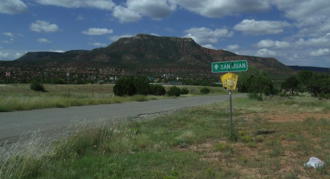
The start of the ghost-town tour on State Highway 3, east of Santa Fe.
After a recent trip to Santa Fe, New Mexico, I was faced with the difficult question of how to keep entertained on the desolate 280-mile trek to my next stop, Amarillo, Texas.
The only thing I could come up with was remembering some research I had done on the Route 66 ghost towns, which lie right off of I-40. The stops would make the trip longer, but would be well worth the anticipation of what I may stumble upon.
After studying the map for possible routes, I opted to head east on I-25 from Santa Fe and exit on the small State Highway 3. I almost ran out of gas, thinking there would be more options than I found. Luckily I found an extremely overpriced gas station, near the town of San Juan, off the highway (top) on a gravel road.
After exiting Highway 3 south, the road starts off nice but has slowly winding curves. You pass through the small villages of Ribera and Sena, which lie right along the highway. Eventually, after the speed limit lowers to 35 mph by necessity, the pleasant mountain village of Villanueva appears.
Villanueva is a small Spanish colonial village on the Pecos River. I have yet to find an accurate count of the population (or when the town was founded), but would estimate it at maybe a couple hundred people. I saw very little activity on the streets, but the historic homes and buildings were well kept. Seeing the village was almost like traveling back in time; it's almost as the village is standing still and has been forgotten by the outside world. A rarely visited state park lies near the town, but I found it best to keep on the road towards I-40 and the remnants of Route 66.
The remainder of Highway 3 until you reach I-40 is straight and smooth, likely without seeing a human, animal or bar of service on your cell phone for over 20 miles. Once you hit I-40 it's 61 miles until the first notable ghost town of Cuervo.
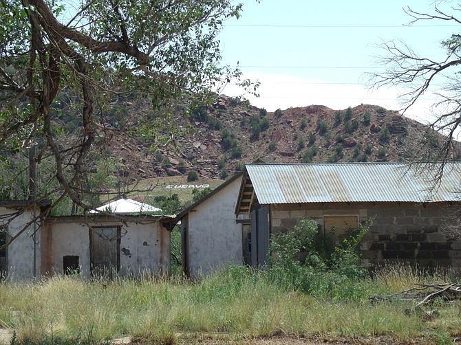
Exiting at Cuervo, you'll see the remains of a village on your right-hand side. There's actually a functional gas station on the north side of I-40, but the ghost town of Cuervo lies on the south. Structures such as a church and school stand proud, while dilapidated houses and barns are scattered at the foot of Cuervo Hill (right).
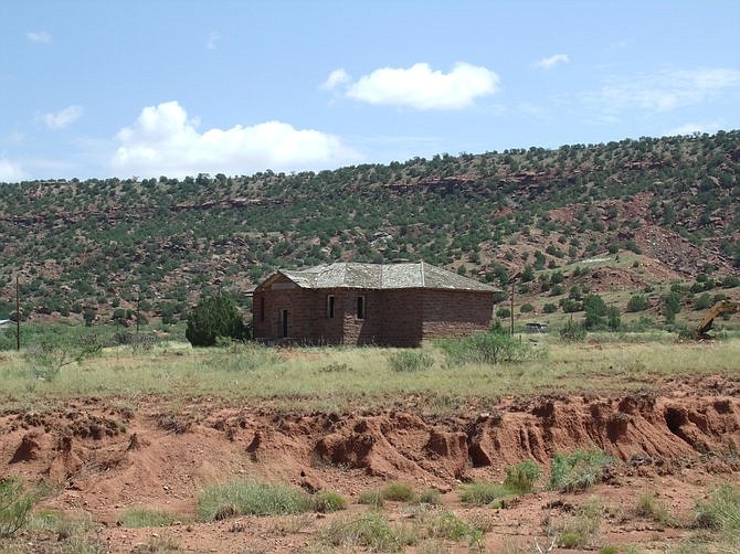
Abandoned school in Cuervo.
Before deciding to explore the inside of any buildings, it's worth noting that one or two of the homes higher up the hill appear to be livable and with vehicles outside. While the ghosts may watch over this town, it appears a few lonely characters do as well.
Strange yet fresh graffiti decorates the inside walls of some of the homes on the main avenue, which fit some of the bizarre stories I have heard from visitors of this ghost town. The feeling you get from this place is far from welcoming, with the sound of rattlesnakes in the bushes not helping the matter either.
Getting back on I-40 headed east, it's a good idea to stop at Tucumcari for fuel and food, as it is one of the last options between this point of eastern New Mexico until you reach Amarillo, Texas. Tucumcari is an odd town, with a long drag consisting mainly of empty yet somehow open motels.
After the stop in Tucumcari, I opted to exit at San Jon, a town that's still home to around 200 people (estimated 306 in 2000; no census has been done on the village since). The area near the exit ramp was full of life, but as you head towards Route 66, which runs east and west just south of town, you can see the deserted town that once thrived.
Route 66 looked to be in great condition, so I opted to head east on it to see how far I could get. I did not find it odd that no other vehicles were around, considering the desolation of the area, but quickly saw the highway turn to gravel. I decided not to push my luck and headed back to I-40.
From San Jon, New Mexico, to the state line of Texas, it's only a little over 18 miles. Two other ghost towns lie between San Jon and the state line, Bard and Endee. Nightfall was approaching, so I opted to hoof it to the state line, but both of the mentioned towns are not far from the highway for those looking to stop.
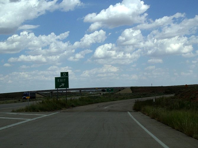
Right over the state line is the infamous I-40 Texas exit 0 (left).
Once you exit 0, head south for a few meters and then back to the west on Route 66. This takes you back to the cross–state line ghost town of Glenrio.
Glenrio was founded in 1903, and the town existed in both Texas and New Mexico (coming with two time zones, separate liquor laws, and varying fuel prices). The town was originally a railroad town and survived off of Route 66 traffic for generations until the construction of I-40 led to its demise in the 1970s.
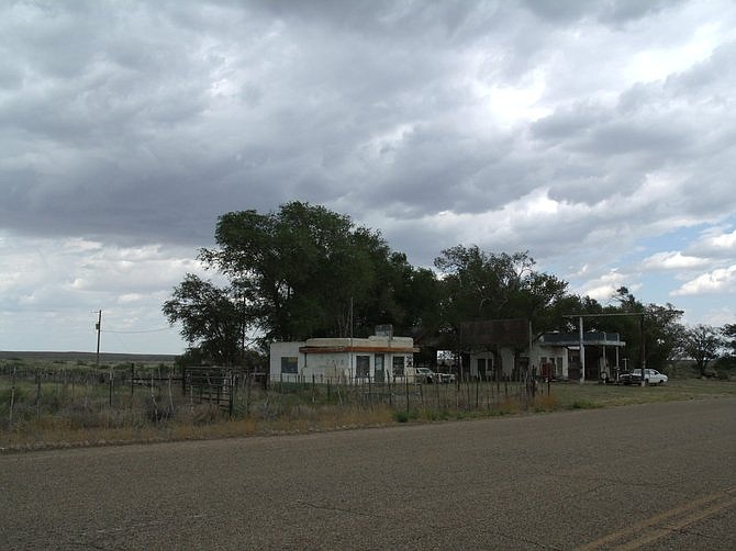
The Little Juarez Café in Glenrio.
Driving through what's left of the town, I saw a number of interesting structures remaining on the north side of the road. A motel, café (The Little Juarez Café), post office and service station still stand strong. A home on the east end of the strip appeared to be occupied, with two working vehicles parked in the driveway.
Headed west on Route 66 will quickly take you from a well-paved road to gravel as you venture back into New Mexico.
Nightfall came quicker than expected, but at this point I was less than an hour from Amarillo. My plan had succeeded on making for an interesting trip. The next time I'm in the area, another journey through more ghost towns may just be my destination.
Here's something you might be interested in.
Ghost towns of New Mexico
Way off-the-beaten-path kicks on Route 66.
Ghost towns of New Mexico
Way off-the-beaten-path kicks on Route 66.
The start of the ghost-town tour on State Highway 3, east of Santa Fe.
After a recent trip to Santa Fe, New Mexico, I was faced with the difficult question of how to keep entertained on the desolate 280-mile trek to my next stop, Amarillo, Texas.
The only thing I could come up with was remembering some research I had done on the Route 66 ghost towns, which lie right off of I-40. The stops would make the trip longer, but would be well worth the anticipation of what I may stumble upon.
After studying the map for possible routes, I opted to head east on I-25 from Santa Fe and exit on the small State Highway 3. I almost ran out of gas, thinking there would be more options than I found. Luckily I found an extremely overpriced gas station, near the town of San Juan, off the highway (top) on a gravel road.
After exiting Highway 3 south, the road starts off nice but has slowly winding curves. You pass through the small villages of Ribera and Sena, which lie right along the highway. Eventually, after the speed limit lowers to 35 mph by necessity, the pleasant mountain village of Villanueva appears.
Villanueva is a small Spanish colonial village on the Pecos River. I have yet to find an accurate count of the population (or when the town was founded), but would estimate it at maybe a couple hundred people. I saw very little activity on the streets, but the historic homes and buildings were well kept. Seeing the village was almost like traveling back in time; it's almost as the village is standing still and has been forgotten by the outside world. A rarely visited state park lies near the town, but I found it best to keep on the road towards I-40 and the remnants of Route 66.
The remainder of Highway 3 until you reach I-40 is straight and smooth, likely without seeing a human, animal or bar of service on your cell phone for over 20 miles. Once you hit I-40 it's 61 miles until the first notable ghost town of Cuervo.
Exiting at Cuervo, you'll see the remains of a village on your right-hand side. There's actually a functional gas station on the north side of I-40, but the ghost town of Cuervo lies on the south. Structures such as a church and school stand proud, while dilapidated houses and barns are scattered at the foot of Cuervo Hill (right).
Abandoned school in Cuervo.
Before deciding to explore the inside of any buildings, it's worth noting that one or two of the homes higher up the hill appear to be livable and with vehicles outside. While the ghosts may watch over this town, it appears a few lonely characters do as well.
Strange yet fresh graffiti decorates the inside walls of some of the homes on the main avenue, which fit some of the bizarre stories I have heard from visitors of this ghost town. The feeling you get from this place is far from welcoming, with the sound of rattlesnakes in the bushes not helping the matter either.
Getting back on I-40 headed east, it's a good idea to stop at Tucumcari for fuel and food, as it is one of the last options between this point of eastern New Mexico until you reach Amarillo, Texas. Tucumcari is an odd town, with a long drag consisting mainly of empty yet somehow open motels.
After the stop in Tucumcari, I opted to exit at San Jon, a town that's still home to around 200 people (estimated 306 in 2000; no census has been done on the village since). The area near the exit ramp was full of life, but as you head towards Route 66, which runs east and west just south of town, you can see the deserted town that once thrived.
Route 66 looked to be in great condition, so I opted to head east on it to see how far I could get. I did not find it odd that no other vehicles were around, considering the desolation of the area, but quickly saw the highway turn to gravel. I decided not to push my luck and headed back to I-40.
From San Jon, New Mexico, to the state line of Texas, it's only a little over 18 miles. Two other ghost towns lie between San Jon and the state line, Bard and Endee. Nightfall was approaching, so I opted to hoof it to the state line, but both of the mentioned towns are not far from the highway for those looking to stop.
Right over the state line is the infamous I-40 Texas exit 0 (left).
Once you exit 0, head south for a few meters and then back to the west on Route 66. This takes you back to the cross–state line ghost town of Glenrio.
Glenrio was founded in 1903, and the town existed in both Texas and New Mexico (coming with two time zones, separate liquor laws, and varying fuel prices). The town was originally a railroad town and survived off of Route 66 traffic for generations until the construction of I-40 led to its demise in the 1970s.
The Little Juarez Café in Glenrio.
Driving through what's left of the town, I saw a number of interesting structures remaining on the north side of the road. A motel, café (The Little Juarez Café), post office and service station still stand strong. A home on the east end of the strip appeared to be occupied, with two working vehicles parked in the driveway.
Headed west on Route 66 will quickly take you from a well-paved road to gravel as you venture back into New Mexico.
Nightfall came quicker than expected, but at this point I was less than an hour from Amarillo. My plan had succeeded on making for an interesting trip. The next time I'm in the area, another journey through more ghost towns may just be my destination.
Comments