Here's something you might be interested in.
Ask a Hipster — Advice you didn't know you needed
Big Screen — Movie commentary
Blurt — Music's inside track
Booze News — San Diego spirits
Classical Music — Immortal beauty
Classifieds — Free and easy
Cover Stories — Front-page features
Drinks All Around — Bartenders' drink recipes
Excerpts — Literary and spiritual excerpts
Feast! — Food & drink reviews
Feature Stories — Local news & stories
Fishing Report — What’s getting hooked from ship and shore
From the Archives — Spotlight on the past
Golden Dreams — Talk of the town
The Gonzo Report — Making the musical scene, or at least reporting from it
Letters — Our inbox
Movies@Home — Local movie buffs share favorites
Movie Reviews — Our critics' picks and pans
Musician Interviews — Up close with local artists
Neighborhood News from Stringers — Hyperlocal news
News Ticker — News & politics
Obermeyer — San Diego politics illustrated
Outdoors — Weekly changes in flora and fauna
Overheard in San Diego — Eavesdropping illustrated
Poetry — The old and the new
Reader Travel — Travel section built by travelers
Reading — The hunt for intellectuals
Roam-O-Rama — SoCal's best hiking/biking trails
San Diego Beer — Inside San Diego suds
SD on the QT — Almost factual news
Sheep and Goats — Places of worship
Special Issues — The best of
Street Style — San Diego streets have style
Surf Diego — Real stories from those braving the waves
Theater — On stage in San Diego this week
Tin Fork — Silver spoon alternative
Under the Radar — Matt Potter's undercover work
Unforgettable — Long-ago San Diego
Unreal Estate — San Diego's priciest pads
Your Week — Daily event picks
Borrego Springs's Mud Caves
Spelunk away: one of the world's most extensive mud cave formations is just two hours east.
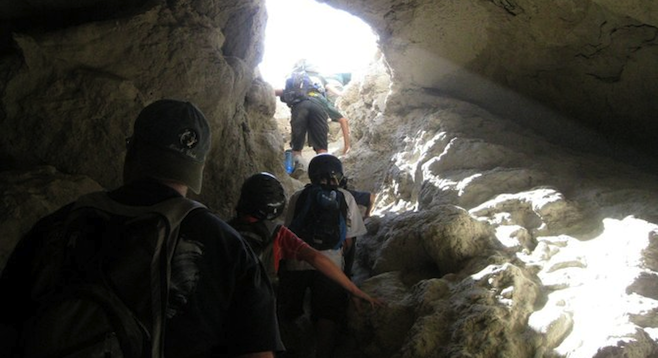
Climbing out of one of the many "mud caves" found in the Anza Borrego Desert. (Photo by Andrew Accardi)
In the geographical wonders of the Anza-Borrego desert, you will find a unique Southern California feature: mud caves, deep caves created by flowing silt from an ancient lake bed, eroded by wind and rain.
They're big enough to walk into and climb through. Some have room-sized caverns. You can also crawl to the top of the prehistoric geological formation and from the elevated summit, scan the desert horizon for miles around.
The actual cave entrances may be hard to spot; they're usually up the hillsides. The state park does not mark their entrances with a sign, but they are readily located on various hiking maps of the area. You’ll need to do your homework. You can usually drive to right below the entrances.
While four-wheel drive vehicles are obviously recommended for going off road, our two-wheel drive vehicles with high clearance made it just fine (a Honda CR-V and an Audi crossover SUV).
In the southern part of the park, about 25 miles north of I-8, the caves draw amateur hikers, including children, and pros alike. In the small community of Cranbrake, you’ll find the dirt road that turns north off Hwy. S2, with the signage “Palm Spring 1.6 Miles.” It is not the Palm Springs. Follow the fairly good dirt road several miles, heading north and east, until you see the sign “Arroyo Tapiado.” Turn left up the Arroyo Tapiado wash about two miles and follow your cave map.
Maps have named some of the caves Carey's Big Mud Cave, Chasm Cave, and E Ticket Cave.
In the caves, wear helmets, headlamps and wet handkerchiefs to cover your mouth from dust. Even though the temperature deep inside the cave is a cool, constant temperature, you will want to drink plenty of water – you're still in the desert. Stay on the paths and watch your step. There are deep holes off to the side of the trails, both inside the caverns and on top of hills. Who knows how far they may drop down into the abyss.
For a real treat, once deep inside a cave, gather up your party and turn off every headlamp. Witness total and complete darkness – something we humans never really experience.
Danger Times
You never want to go to into the mud caves or anywhere back in these desert arroyos anytime it rains or there's been an earthquake.
The dirt roads, arroyos and caves have been channeled out of fine sediment and will become raging, muddy rivers taking everything but firmly rooted plants in their wake. Since one can’t predict an earthquake, that intensifies the visit, but get away from high canyon walls and scrabble out of caves should one occur.
Thirdly, the 110+ degree temperatures of the summer will bake you just getting out of your vehicle at the cave entrance. Things cool off in the fall, winter or spring.
Getting There
The quickest way for most, even from North County, is to go east on I-8. Going this way you’ll save some time missing the Hwy. 78 twisty-turnies, but will sadly miss Julian’s apple pie. On the plus side, no one gets carsick.
Over the summit of the Lagunas and a quick descent down to the desert floor, exit at the Imperial Valley town of Ocotillo. Head north through the tiny community on what is known as the The Great Southern Overland Stage Route of 1849. In Imperial County it’s also known as the Imperial Highway.
Once past the Border Patrol checkpoint (yes, those are real machine guns they are holding), you’re back in San Diego County and on the clearly marked County Road S2.
Travel tip: watch your cell phone usage when driving between the Golden Acorn Casino, through Jacumba, to the top of the grade at Boulevard. You could easily pick up a Mexican cell tower and be charged international rates - $1.00+/minute.
On some parts of I-8, the border is only a mile away. The border fence can be seen from I-8 near the Jacumba exit.
Here's something you might be interested in.
Borrego Springs's Mud Caves
Spelunk away: one of the world's most extensive mud cave formations is just two hours east.
Borrego Springs's Mud Caves
Spelunk away: one of the world's most extensive mud cave formations is just two hours east.
Climbing out of one of the many "mud caves" found in the Anza Borrego Desert. (Photo by Andrew Accardi)
In the geographical wonders of the Anza-Borrego desert, you will find a unique Southern California feature: mud caves, deep caves created by flowing silt from an ancient lake bed, eroded by wind and rain.
They're big enough to walk into and climb through. Some have room-sized caverns. You can also crawl to the top of the prehistoric geological formation and from the elevated summit, scan the desert horizon for miles around.
The actual cave entrances may be hard to spot; they're usually up the hillsides. The state park does not mark their entrances with a sign, but they are readily located on various hiking maps of the area. You’ll need to do your homework. You can usually drive to right below the entrances.
While four-wheel drive vehicles are obviously recommended for going off road, our two-wheel drive vehicles with high clearance made it just fine (a Honda CR-V and an Audi crossover SUV).
In the southern part of the park, about 25 miles north of I-8, the caves draw amateur hikers, including children, and pros alike. In the small community of Cranbrake, you’ll find the dirt road that turns north off Hwy. S2, with the signage “Palm Spring 1.6 Miles.” It is not the Palm Springs. Follow the fairly good dirt road several miles, heading north and east, until you see the sign “Arroyo Tapiado.” Turn left up the Arroyo Tapiado wash about two miles and follow your cave map.
Maps have named some of the caves Carey's Big Mud Cave, Chasm Cave, and E Ticket Cave.
In the caves, wear helmets, headlamps and wet handkerchiefs to cover your mouth from dust. Even though the temperature deep inside the cave is a cool, constant temperature, you will want to drink plenty of water – you're still in the desert. Stay on the paths and watch your step. There are deep holes off to the side of the trails, both inside the caverns and on top of hills. Who knows how far they may drop down into the abyss.
For a real treat, once deep inside a cave, gather up your party and turn off every headlamp. Witness total and complete darkness – something we humans never really experience.
Danger Times
You never want to go to into the mud caves or anywhere back in these desert arroyos anytime it rains or there's been an earthquake.
The dirt roads, arroyos and caves have been channeled out of fine sediment and will become raging, muddy rivers taking everything but firmly rooted plants in their wake. Since one can’t predict an earthquake, that intensifies the visit, but get away from high canyon walls and scrabble out of caves should one occur.
Thirdly, the 110+ degree temperatures of the summer will bake you just getting out of your vehicle at the cave entrance. Things cool off in the fall, winter or spring.
Getting There
The quickest way for most, even from North County, is to go east on I-8. Going this way you’ll save some time missing the Hwy. 78 twisty-turnies, but will sadly miss Julian’s apple pie. On the plus side, no one gets carsick.
Over the summit of the Lagunas and a quick descent down to the desert floor, exit at the Imperial Valley town of Ocotillo. Head north through the tiny community on what is known as the The Great Southern Overland Stage Route of 1849. In Imperial County it’s also known as the Imperial Highway.
Once past the Border Patrol checkpoint (yes, those are real machine guns they are holding), you’re back in San Diego County and on the clearly marked County Road S2.
Travel tip: watch your cell phone usage when driving between the Golden Acorn Casino, through Jacumba, to the top of the grade at Boulevard. You could easily pick up a Mexican cell tower and be charged international rates - $1.00+/minute.
On some parts of I-8, the border is only a mile away. The border fence can be seen from I-8 near the Jacumba exit.
Comments