Here's something you might be interested in.
Ask a Hipster — Advice you didn't know you needed
Big Screen — Movie commentary
Blurt — Music's inside track
Booze News — San Diego spirits
Classical Music — Immortal beauty
Classifieds — Free and easy
Cover Stories — Front-page features
Drinks All Around — Bartenders' drink recipes
Excerpts — Literary and spiritual excerpts
Feast! — Food & drink reviews
Feature Stories — Local news & stories
Fishing Report — What’s getting hooked from ship and shore
From the Archives — Spotlight on the past
Golden Dreams — Talk of the town
The Gonzo Report — Making the musical scene, or at least reporting from it
Letters — Our inbox
Movies@Home — Local movie buffs share favorites
Movie Reviews — Our critics' picks and pans
Musician Interviews — Up close with local artists
Neighborhood News from Stringers — Hyperlocal news
News Ticker — News & politics
Obermeyer — San Diego politics illustrated
Outdoors — Weekly changes in flora and fauna
Overheard in San Diego — Eavesdropping illustrated
Poetry — The old and the new
Reader Travel — Travel section built by travelers
Reading — The hunt for intellectuals
Roam-O-Rama — SoCal's best hiking/biking trails
San Diego Beer — Inside San Diego suds
SD on the QT — Almost factual news
Sheep and Goats — Places of worship
Special Issues — The best of
Street Style — San Diego streets have style
Surf Diego — Real stories from those braving the waves
Theater — On stage in San Diego this week
Tin Fork — Silver spoon alternative
Under the Radar — Matt Potter's undercover work
Unforgettable — Long-ago San Diego
Unreal Estate — San Diego's priciest pads
Your Week — Daily event picks
Charmlee Wilderness Park
Charmlee Wilderness Park (a.k.a. Charmlee Natural Area), 590 acres of meadow, oak woodland, sage scrub, and chaparral, was first opened to the public in 1981 as a unit of the Los Angeles County park system. Today the City of Malibu administers the park, which lies on that coastal community’s western extremity.
Never designed to accommodate a large number of visitors, Charmlee’s parking lot is often full on weekends. A spiderweb of trails totaling eight miles covers the park, making it a great place to ramble with family and friends (and pets) for the purpose of wildflower spotting in spring and ocean watching on any clear day. Those clear days will increase in frequency into late fall and winter, when clear, dry air predominates over the region more often than not.
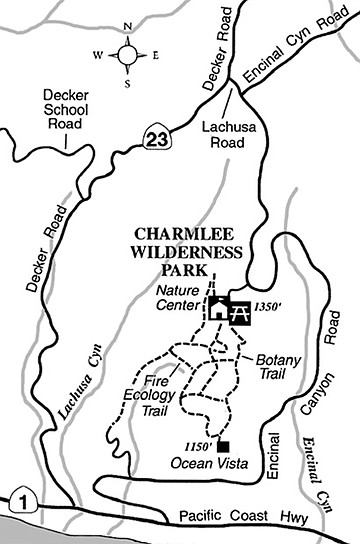
To get to Charmlee Wilderness Park from Santa Monica, drive 25 miles west on Pacific Coast Highway (Highway 1), turn north on Encinal Canyon Road, and proceed north four miles to the park’s well-marked entrance. Gates are open 8 a.m. to sunset daily. The following is one possible route to follow on foot:
From the parking lot, walk on pavement to the nature center (inside, pick up a guide for the Fire Ecology Trail and other interpretive materials). Bear right on a paved road, soon dirt, that bends north up a slope. Make an acute left turn at the top, follow a ridge road past a hilltop water tank (detour and walk around the tank for a good overview of the park and the ocean), and then curve down to a T-intersection. Jog right, then go left on the Fire Ecology Trail. After a few minutes you will be passing under some fire-singed coast live oaks, which are well known for their ability to survive fast-moving wildfires.
Next, go right on the wide trail that winds along the west edge of Charmlee’s large, central meadow. Continue all the way to a dry ridge topped by some old eucalyptus trees and a concrete-lined cistern, both relics of cattle-ranching days. From there descend south (stay right at the next junction) to the “Ocean Vista,” which on clear days fulfills what its name suggests. In addition to miles of surf and sand seemingly at your feet, your eyes drink in perhaps a thousand square miles of wind-ruffled ocean.
Circle north from Ocean Vista around the hill with the cistern and then along the east side of the meadow. When you come to the northeast part of the meadow and the dirt road curves west, pick up the hard-to-spot Botany Trail on the right. It winds through mostly chaparral vegetation and takes you to the picnic area just above your starting point.
This article contains information about a publicly owned recreation or wilderness area. Trails and pathways are not necessarily marked. Conditions can change rapidly. Hikers should be properly equipped and have safety and navigational skills. The Reader and Jerry Schad assume no responsibility for any adverse experience.
Charmlee Wilderness Park
Enjoy fog-free views of the Pacific Ocean from Malibu’s Charmlee Wilderness Park.
Distance from downtown San Diego: 165 miles
Hiking length: 2.8 miles
Difficulty: Moderate
Here's something you might be interested in.
Charmlee Wilderness Park
Charmlee Wilderness Park
Charmlee Wilderness Park (a.k.a. Charmlee Natural Area), 590 acres of meadow, oak woodland, sage scrub, and chaparral, was first opened to the public in 1981 as a unit of the Los Angeles County park system. Today the City of Malibu administers the park, which lies on that coastal community’s western extremity.
Never designed to accommodate a large number of visitors, Charmlee’s parking lot is often full on weekends. A spiderweb of trails totaling eight miles covers the park, making it a great place to ramble with family and friends (and pets) for the purpose of wildflower spotting in spring and ocean watching on any clear day. Those clear days will increase in frequency into late fall and winter, when clear, dry air predominates over the region more often than not.
To get to Charmlee Wilderness Park from Santa Monica, drive 25 miles west on Pacific Coast Highway (Highway 1), turn north on Encinal Canyon Road, and proceed north four miles to the park’s well-marked entrance. Gates are open 8 a.m. to sunset daily. The following is one possible route to follow on foot:
From the parking lot, walk on pavement to the nature center (inside, pick up a guide for the Fire Ecology Trail and other interpretive materials). Bear right on a paved road, soon dirt, that bends north up a slope. Make an acute left turn at the top, follow a ridge road past a hilltop water tank (detour and walk around the tank for a good overview of the park and the ocean), and then curve down to a T-intersection. Jog right, then go left on the Fire Ecology Trail. After a few minutes you will be passing under some fire-singed coast live oaks, which are well known for their ability to survive fast-moving wildfires.
Next, go right on the wide trail that winds along the west edge of Charmlee’s large, central meadow. Continue all the way to a dry ridge topped by some old eucalyptus trees and a concrete-lined cistern, both relics of cattle-ranching days. From there descend south (stay right at the next junction) to the “Ocean Vista,” which on clear days fulfills what its name suggests. In addition to miles of surf and sand seemingly at your feet, your eyes drink in perhaps a thousand square miles of wind-ruffled ocean.
Circle north from Ocean Vista around the hill with the cistern and then along the east side of the meadow. When you come to the northeast part of the meadow and the dirt road curves west, pick up the hard-to-spot Botany Trail on the right. It winds through mostly chaparral vegetation and takes you to the picnic area just above your starting point.
This article contains information about a publicly owned recreation or wilderness area. Trails and pathways are not necessarily marked. Conditions can change rapidly. Hikers should be properly equipped and have safety and navigational skills. The Reader and Jerry Schad assume no responsibility for any adverse experience.
Charmlee Wilderness Park
Enjoy fog-free views of the Pacific Ocean from Malibu’s Charmlee Wilderness Park.
Distance from downtown San Diego: 165 miles
Hiking length: 2.8 miles
Difficulty: Moderate